Bridge Statistics for Varnell, Georgia (GA)
Condition, Traffic, Stress, Structural Evaluation, Project Costs
- National Bridge Inventory (NBI) Statistics
- 12Number of bridges
- 62ft / 18.9mTotal length
- $4,031,000Total costs
- 84,454Total average daily traffic
- 1,088Total average daily truck traffic
- 126,681Total future (year 2031) average daily traffic
- National Bridge Inventory (NBI) Registered Bridges for Varnell
- No street view available for this location
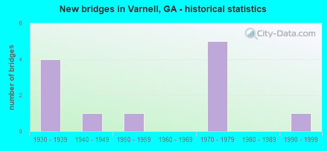
- New bridges - historical statistics
- 41930-1939
- 11940-1949
- 11950-1959
- 51970-1979
- 11990-1999

- Reconstructed bridges - Historical Statistics
- 11950-1959
- 01960-1969
- 21970-1979
- 01980-1989
- 21990-1999


- Bridge Condition - Deck
- 25.0%Very good
- 50.0%Good
- 25.0%Satisfactory

- Bridge Condition - Superstructure
- 50.0%Good
- 50.0%Satisfactory

- Bridge Condition - Substructure
- 50.0%Good
- 50.0%Satisfactory

- Bridge Condition - Channel
- 81.8%Very good
- 9.1%Good
- 9.1%Satisfactory

- Bridge Condition - Culverts
- 62.5%Good
- 37.5%Fair
Find on map >> Show street view
Structure Number: 475027, Location: 5 MI E OF RINGGOLD (Lat: 34.912597, Lng: -85.022989), Route carried "on" structure: County highway 374, Year Built: 1978, Status: Posted for load, Structure Length: 0.76m (2.49ft), Average Daily Traffic: 80 (year 2011), Truck Traffic: 1%, Average Future Daily Traffic: 120 (year 2031), Features Intersected: LITTLE TIGER CREEK, Facility Carried by Structure: COOPER ROAD
Minimum Vertical Clearance: 30+ m (98+ ft), Kilometerpoint: 0.000, Lanes on structure: 2, Owner: County Highway Agency, Approaching Roadway Width: 6.1m (20.0ft), Material/Design: Steel, Design/Construction: Stringer/Multi-beam, Number Of Spans In Main Unit: 1, Length of Maximum Span: 7.6m (24.9ft), Curb-To-Curb Width: 7.4m (24.3ft), Out-to-Out Width: 8.5m (27.9ft)
Condition: Deck: Very good, Superstructure: Satisfactory, Substructure: Good, Channel: Very good, Operating Rating: 10.8 metric tons, Method Used To Determine Operating Rating: Load Factor (LF), Inventory Rating: 6.3 metric tons, Method Used To Determine Inventory Rating: Load Factor (LF), Structural Evaluation: High priority of replacement, Deck Geometry: Equal to present minimum criteria, Waterway Adequacy: Superior to present desirable criteria, Approach Roadway Alignment: Equal to present desirable criteria, Bridge Posting: Required (Relationship of Operating Rating to Maximum Legal Load: > 39.9% below), Length Of Structure Improvement: 7.19m (23.59ft), Designated Inspection Frequency: Every 24 months, Inspection Date: January 2022, Bridge Improvement Cost: $98,000, Roadway Improvement Cost: $10,000, Total Project Cost: $147,000, Deck Structure Type: Concrete Cast-file-Place, Wearing Surface/Protective System: Wearing Surface: Bituminous
Find on map >> Show street view
Structure Number: 475034, Location: 5 MI. E OF RINGGOLD (Lat: 34.921128, Lng: -85.025408), Route carried "on" structure: County highway 213, Year Built: 1996, Status: Open, Structure Length: 0.98m (3.22ft), Average Daily Traffic: 60 (year 2011), Truck Traffic: 1%, Average Future Daily Traffic: 90 (year 2031), Design Load: HS 20+Mod, Features Intersected: LITTLE TIGER CREEK, Facility Carried by Structure: SMITH CHAPEL ROAD
Minimum Vertical Clearance: 30+ m (98+ ft), Kilometerpoint: 1.609, Lanes on structure: 2, Owner: County Highway Agency, Approaching Roadway Width: 6.4m (21.0ft), Material/Design: Concrete, Design/Construction: Culvert, Number Of Spans In Main Unit: 3, Length of Maximum Span: 3.0m (9.8ft)
Condition: Channel: Very good, Culverts: Good, Operating Rating: 55.3 metric tons, Method Used To Determine Operating Rating: Field evaluation and documented engineering judgment, Inventory Rating: 32.6 metric tons, Method Used To Determine Inventory Rating: Field evaluation and documented engineering judgment, Structural Evaluation: Better than present minimum criteria, Waterway Adequacy: Superior to present desirable criteria, Approach Roadway Alignment: Equal to present desirable criteria, Designated Inspection Frequency: Every 24 months, Inspection Date: January 2022, Bridge Improvement Cost: $125,000, Roadway Improvement Cost: $13,000, Total Project Cost: $188,000
Find on map >> Show street view
Structure Number: 3130001, Location: IN SOUTH WEST VARNELL (Lat: 34.898386, Lng: -84.974289), Route carried "on" structure: State highway 2, Year Built: 1970, Status: Open, Structure Length: 4.88m (16.01ft), Average Daily Traffic: 7,220 (year 2011), Truck Traffic: 1%, Average Future Daily Traffic: 10,830 (year 2031), Design Load: HS 20+Mod, Features Intersected: NS RAILROAD (719700X)
Minimum Vertical Clearance: 30+ m (98+ ft), Kilometerpoint: 4.828, Lanes on structure: 2, Base Highway Network: Yes, Owner: State Highway Agency, Approaching Roadway Width: 8.5m (27.9ft), Skew: 1 degrees, Material/Design: Steel, Design/Construction: Stringer/Multi-beam, Number Of Spans In Main Unit: 3, Length of Maximum Span: 16.5m (54.1ft), Curb-To-Curb Width: 12.2m (40.0ft), Out-to-Out Width: 12.9m (42.3ft)
Condition: Deck: Good, Superstructure: Good, Substructure: Satisfactory, Operating Rating: 41.7 metric tons, Method Used To Determine Operating Rating: Load Factor (LF), Inventory Rating: 25.4 metric tons, Method Used To Determine Inventory Rating: Load Factor (LF), Structural Evaluation: Equal to present minimum criteria, Deck Geometry: Somewhat better than minimum adequacy, Underclear: Somewhat better than minimum adequacy, Approach Roadway Alignment: Equal to present desirable criteria, Designated Inspection Frequency: Every 24 months, Inspection Date: April 2020, Bridge Improvement Cost: $625,000, Roadway Improvement Cost: $63,000, Total Project Cost: $938,000, Deck Structure Type: Concrete Cast-file-Place
Find on map >> Show street view
Structure Number: 3130002, Location: IN SOUTH WEST VARNELL (Lat: 34.899028, Lng: -84.967169), Route carried "on" structure: State highway 2, Year Built: 1970, Status: Open, Structure Length: 1.01m (3.31ft), Average Daily Traffic: 7,220 (year 2011), Truck Traffic: 1%, Average Future Daily Traffic: 10,830 (year 2031), Design Load: HS 20+Mod, Features Intersected: KENYON CREEK
Minimum Vertical Clearance: 30+ m (98+ ft), Kilometerpoint: 6.437, Lanes on structure: 2, Base Highway Network: Yes, Owner: State Highway Agency, Approaching Roadway Width: 8.2m (26.9ft), Skew: 2 degrees, Material/Design: Concrete, Design/Construction: Culvert, Number Of Spans In Main Unit: 3, Length of Maximum Span: 3.0m (9.8ft)
Condition: Channel: Very good, Culverts: Fair, Operating Rating: 55.3 metric tons, Method Used To Determine Operating Rating: Field evaluation and documented engineering judgment, Inventory Rating: 32.6 metric tons, Method Used To Determine Inventory Rating: Field evaluation and documented engineering judgment, Structural Evaluation: Somewhat better than minimum adequacy, Waterway Adequacy: Superior to present desirable criteria, Approach Roadway Alignment: Equal to present desirable criteria, Designated Inspection Frequency: Every 24 months, Inspection Date: April 2020, Bridge Improvement Cost: $129,000, Roadway Improvement Cost: $13,000, Total Project Cost: $193,000
Find on map >> Show street view
Structure Number: 3130003, Location: 1.5 MI E OF VARNELL (Lat: 34.895458, Lng: -84.920939), Route carried "on" structure: State highway 2, Year Built: 1970, Status: Open, Structure Length: 5.03m (16.50ft), Average Daily Traffic: 2,090 (year 2011), Truck Traffic: 13%, Average Future Daily Traffic: 3,135 (year 2031), Design Load: HS 20+Mod, Features Intersected: COAHULLA CREEK
Minimum Vertical Clearance: 30+ m (98+ ft), Kilometerpoint: 9.656, Lanes on structure: 2, Base Highway Network: Yes, Owner: State Highway Agency, Approaching Roadway Width: 8.5m (27.9ft), Material/Design: Steel, Design/Construction: Stringer/Multi-beam, Number Of Spans In Main Unit: 3, Length of Maximum Span: 16.8m (55.1ft), Curb-To-Curb Width: 12.2m (40.0ft), Out-to-Out Width: 12.9m (42.3ft)
Condition: Deck: Good, Superstructure: Good, Substructure: Good, Channel: Very good, Operating Rating: 35.3 metric tons, Method Used To Determine Operating Rating: Load Factor (LF), Inventory Rating: 20.8 metric tons, Method Used To Determine Inventory Rating: Load Factor (LF), Structural Evaluation: Somewhat better than minimum adequacy, Deck Geometry: Equal to present minimum criteria, Waterway Adequacy: Superior to present desirable criteria, Approach Roadway Alignment: Equal to present desirable criteria, Designated Inspection Frequency: Every 24 months, Inspection Date: May 2020, Bridge Improvement Cost: $645,000, Roadway Improvement Cost: $64,000, Total Project Cost: $967,000, Deck Structure Type: Concrete Cast-file-Place
Find on map >> Show street view
Structure Number: 3130027, Location: 4.9 MI NE OF DALTON (Lat: 34.839856, Lng: -84.942964), Route carried "on" structure: State highway 71, Year Built: 1933, Year Reconstructed: 1979, Status: Open, Structure Length: 0.98m (3.22ft), Average Daily Traffic: 18,190 (year 2011), Truck Traffic: 1%, Average Future Daily Traffic: 27,285 (year 2031), Design Load: H 15, Features Intersected: COAHULLA CREEK TRIB
Minimum Vertical Clearance: 30+ m (98+ ft), Kilometerpoint: 4.828, Lanes on structure: 5, Base Highway Network: Yes, Owner: State Highway Agency, Approaching Roadway Width: 19.5m (64.0ft), Material/Design: Concrete, Design/Construction: Culvert, Number Of Spans In Main Unit: 3, Length of Maximum Span: 3.0m (9.8ft), Curb or Sidewalk Widths: Left: 1.5m (4.9ft), Right: 1.5m (4.9ft)
Condition: Channel: Satisfactory, Culverts: Good, Operating Rating: 63.5 metric tons, Method Used To Determine Operating Rating: Load Factor (LF), Inventory Rating: 38.1 metric tons, Method Used To Determine Inventory Rating: Load Factor (LF), Structural Evaluation: Better than present minimum criteria, Waterway Adequacy: Superior to present desirable criteria, Approach Roadway Alignment: Equal to present desirable criteria, Designated Inspection Frequency: Every 24 months, Inspection Date: May 2020, Bridge Improvement Cost: $227,000, Roadway Improvement Cost: $23,000, Total Project Cost: $341,000
Find on map >> Show street view
Structure Number: 3130028, Location: 7.8 MI N OF DALTON (Lat: 34.884264, Lng: -84.945806), Route carried "on" structure: State highway 71, Year Built: 1933, Year Reconstructed: 1998, Status: Open, Structure Length: 0.98m (3.22ft), Average Daily Traffic: 13,050 (year 2011), Truck Traffic: 1%, Average Future Daily Traffic: 19,575 (year 2031), Design Load: H 15, Features Intersected: STONE BRANCH
Minimum Vertical Clearance: 30+ m (98+ ft), Kilometerpoint: 9.656, Lanes on structure: 2, Base Highway Network: Yes, Owner: State Highway Agency, Approaching Roadway Width: 20.1m (65.9ft), Material/Design: Concrete, Design/Construction: Culvert, Number Of Spans In Main Unit: 3, Length of Maximum Span: 3.0m (9.8ft)
Condition: Channel: Very good, Culverts: Good, Operating Rating: 41.7 metric tons, Method Used To Determine Operating Rating: Field evaluation and documented engineering judgment, Inventory Rating: 24.4 metric tons, Method Used To Determine Inventory Rating: Field evaluation and documented engineering judgment, Structural Evaluation: Equal to present minimum criteria, Waterway Adequacy: Equal to present desirable criteria, Approach Roadway Alignment: Equal to present desirable criteria, Designated Inspection Frequency: Every 24 months, Underwater Inspection Frequency: Every 60 months, Inspection Date: May 2020, Underwater Inspection Date: July 2019, Bridge Improvement Cost: $125,000, Roadway Improvement Cost: $13,000, Total Project Cost: $188,000
Find on map >> Show street view
Structure Number: 3130029, Location: 8.1 MI N OF DALTON (Lat: 34.889531, Lng: -84.946367), Route carried "on" structure: State highway 71, Year Built: 1933, Year Reconstructed: 1998, Status: Open, Structure Length: 0.98m (3.22ft), Average Daily Traffic: 13,050 (year 2011), Truck Traffic: 1%, Average Future Daily Traffic: 19,575 (year 2031), Design Load: H 15, Features Intersected: KENYON CREEK
Minimum Vertical Clearance: 30+ m (98+ ft), Kilometerpoint: 11.265, Lanes on structure: 5, Base Highway Network: Yes, Owner: State Highway Agency, Approaching Roadway Width: 20.1m (65.9ft), Skew: 1 degrees, Material/Design: Concrete, Design/Construction: Culvert, Number Of Spans In Main Unit: 3, Length of Maximum Span: 3.0m (9.8ft)
Condition: Channel: Very good, Culverts: Good, Operating Rating: 63.5 metric tons, Method Used To Determine Operating Rating: Load Factor (LF), Inventory Rating: 38.1 metric tons, Method Used To Determine Inventory Rating: Load Factor (LF), Structural Evaluation: Better than present minimum criteria, Waterway Adequacy: Equal to present minimum criteria, Approach Roadway Alignment: Equal to present desirable criteria, Designated Inspection Frequency: Every 24 months, Underwater Inspection Frequency: Every 60 months, Inspection Date: May 2020, Underwater Inspection Date: July 2019, Bridge Improvement Cost: $227,000, Roadway Improvement Cost: $23,000, Total Project Cost: $341,000
Find on map >> Show street view
Structure Number: 3130075, Location: 4.9 MI NE OF DALTON (Lat: 34.840292, Lng: -84.942981), Route carried "on" structure: State highway 71, Year Built: 1933, Year Reconstructed: 1979, Status: Open, Structure Length: 0.64m (2.10ft), Average Daily Traffic: 18,190 (year 2011), Truck Traffic: 1%, Average Future Daily Traffic: 27,285 (year 2031), Design Load: H 15, Features Intersected: COAHULLA CREEK TRIB
Minimum Vertical Clearance: 30+ m (98+ ft), Kilometerpoint: 4.828, Lanes on structure: 5, Base Highway Network: Yes, Owner: State Highway Agency, Approaching Roadway Width: 19.5m (64.0ft), Skew: 9 degrees, Material/Design: Concrete, Design/Construction: Culvert, Number Of Spans In Main Unit: 3, Length of Maximum Span: 1.8m (5.9ft), Curb or Sidewalk Widths: Left: 1.5m (4.9ft), Right: 1.5m (4.9ft)
Condition: Channel: Very good, Culverts: Good, Operating Rating: 68.9 metric tons, Method Used To Determine Operating Rating: Load Factor (LF), Inventory Rating: 41.7 metric tons, Method Used To Determine Inventory Rating: Load Factor (LF), Structural Evaluation: Better than present minimum criteria, Waterway Adequacy: Superior to present desirable criteria, Approach Roadway Alignment: Equal to present desirable criteria, Designated Inspection Frequency: Every 24 months, Inspection Date: May 2020, Bridge Improvement Cost: $149,000, Roadway Improvement Cost: $15,000, Total Project Cost: $224,000
Find on map >> Show street view
Structure Number: 313503, Location: 1 MI E OF VARNELL (Lat: 34.895519, Lng: -84.963069), Route carried "on" structure: County highway 215, Year Built: 1978, Status: Open, Structure Length: 1.01m (3.31ft), Average Daily Traffic: 1,768 (year 2011), Truck Traffic: 1%, Average Future Daily Traffic: 2,652 (year 2031), Design Load: H 15, Features Intersected: KENYON CREEK, Facility Carried by Structure: MEERS ROAD
Minimum Vertical Clearance: 30+ m (98+ ft), Kilometerpoint: 0.000, Lanes on structure: 2, Base Highway Network: Yes, Owner: County Highway Agency, Approaching Roadway Width: 6.1m (20.0ft), Skew: 2 degrees, Material/Design: Steel, Design/Construction: Culvert, Number Of Spans In Main Unit: 4, Length of Maximum Span: 2.1m (6.9ft)
Condition: Channel: Very good, Culverts: Fair, Operating Rating: 41.7 metric tons, Method Used To Determine Operating Rating: Field evaluation and documented engineering judgment, Inventory Rating: 24.4 metric tons, Method Used To Determine Inventory Rating: Field evaluation and documented engineering judgment, Structural Evaluation: Somewhat better than minimum adequacy, Waterway Adequacy: Superior to present desirable criteria, Approach Roadway Alignment: Equal to present desirable criteria, Designated Inspection Frequency: Every 24 months, Inspection Date: April 2020, Bridge Improvement Cost: $129,000, Roadway Improvement Cost: $13,000, Total Project Cost: $193,000
Find on map >> Show street view
Structure Number: 3135031, Location: 3.9 MI SW OF VARNELL (Lat: 34.843069, Lng: -84.978547), Route carried "on" structure: County highway 237, Year Built: 1941, Year Reconstructed: 1956, Status: Posted for load, Structure Length: 0.91m (2.99ft), Average Daily Traffic: 1,768 (year 2011), Truck Traffic: 1%, Average Future Daily Traffic: 2,652 (year 2031), Features Intersected: POPLAR SPRING CREEK, Facility Carried by Structure: REED POND ROAD
Minimum Vertical Clearance: 30+ m (98+ ft), Kilometerpoint: 4.828, Lanes on structure: 2, Base Highway Network: Yes, Owner: County Highway Agency, Approaching Roadway Width: 6.4m (21.0ft), Skew: 4 degrees, Material/Design: Steel, Design/Construction: Stringer/Multi-beam, Number Of Spans In Main Unit: 1, Length of Maximum Span: 9.1m (29.9ft), Curb-To-Curb Width: 7.8m (25.6ft), Out-to-Out Width: 8.1m (26.6ft)
Condition: Deck: Satisfactory, Superstructure: Satisfactory, Substructure: Satisfactory, Channel: Good, Operating Rating: 19.0 metric tons, Method Used To Determine Operating Rating: Load Factor (LF), Inventory Rating: 10.8 metric tons, Method Used To Determine Inventory Rating: Load Factor (LF), Structural Evaluation: High priority of replacement, Deck Geometry: Meets minimum limits, Waterway Adequacy: High priority of corrective action, Approach Roadway Alignment: Meets minimum limits, Bridge Posting: Required (Relationship of Operating Rating to Maximum Legal Load: > 39.9% below), Length Of Structure Improvement: 41.42m (135.89ft), Designated Inspection Frequency: Every 24 months, Inspection Date: May 2020, Bridge Improvement Cost: $117,000, Roadway Improvement Cost: $12,000, Total Project Cost: $176,000, Deck Structure Type: Concrete Cast-file-Place, Wearing Surface/Protective System: Wearing Surface: Bituminous
Find on map >> Show street view
Structure Number: 3135037, Location: IN SOUTH EAST VARNELL (Lat: 34.900139, Lng: -84.967908), Route carried "on" structure: City street 313, Year Built: 1950, Status: Open, Structure Length: 0.70m (2.30ft), Average Daily Traffic: 1,768 (year 2011), Truck Traffic: 1%, Average Future Daily Traffic: 2,652 (year 2031), Design Load: H 15, Features Intersected: KENYON CREEK, Facility Carried by Structure: MAIN STREET
Minimum Vertical Clearance: 30+ m (98+ ft), Kilometerpoint: 0.000, Lanes on structure: 2, Base Highway Network: Yes, Owner: City or Municipal Highway Agency, Approaching Roadway Width: 5.8m (19.0ft), Material/Design: Steel, Design/Construction: Culvert, Number Of Spans In Main Unit: 4, Length of Maximum Span: 1.5m (4.9ft)
Condition: Channel: Very good, Culverts: Fair, Operating Rating: 41.7 metric tons, Method Used To Determine Operating Rating: Field evaluation and documented engineering judgment, Inventory Rating: 24.4 metric tons, Method Used To Determine Inventory Rating: Field evaluation and documented engineering judgment, Structural Evaluation: Somewhat better than minimum adequacy, Waterway Adequacy: Equal to present minimum criteria, Approach Roadway Alignment: Equal to present desirable criteria, Designated Inspection Frequency: Every 24 months, Inspection Date: April 2020, Bridge Improvement Cost: $90,000, Roadway Improvement Cost: $9,000, Total Project Cost: $135,000