Bridge Statistics for Versailles, Illinois (IL)
Condition, Traffic, Stress, Structural Evaluation, Project Costs
- National Bridge Inventory (NBI) Statistics
- 16Number of bridges
- 194ft / 59.2mTotal length
- $13,810,000Total costs
- 10,700Total average daily traffic
- 692Total average daily truck traffic
- 11,741Total future (year 2032) average daily traffic
- National Bridge Inventory (NBI) Registered Bridges for Versailles
- No street view available for this location
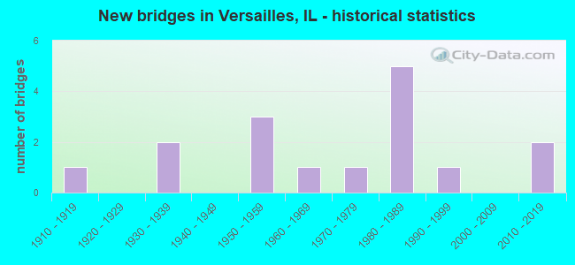
- New bridges - historical statistics
- 11910-1919
- 21930-1939
- 31950-1959
- 11960-1969
- 11970-1979
- 51980-1989
- 11990-1999
- 22010-2019

- Reconstructed bridges - Historical Statistics
- 11970-1979
- 11980-1989
- 01990-1999
- 12000-2009


- Bridge Condition - Deck
- 7.7%Very good
- 69.2%Good
- 7.7%Satisfactory
- 15.4%Poor

- Bridge Condition - Superstructure
- 15.4%Very good
- 46.2%Good
- 7.7%Satisfactory
- 15.4%Fair
- 15.4%Poor

- Bridge Condition - Substructure
- 30.8%Very good
- 38.5%Good
- 15.4%Satisfactory
- 7.7%Fair
- 7.7%Poor

- Bridge Condition - Channel
- 14.3%Very good
- 14.3%Good
- 50.0%Satisfactory
- 21.4%Fair

- Bridge Condition - Culverts
- 33.3%Good
- 33.3%Satisfactory
- 33.3%Poor
Find on map >> Show street view
Structure Number: 36, Location: 1.00 MI E IL 127 (Lat: 38.885942, Lng: -89.374033), Route carried "on" structure: City street , Year Built: 2011, Status: Open, Structure Length: 10.57m (34.68ft), Average Daily Traffic: 225 (year 2020), Truck Traffic: 21%, Average Future Daily Traffic: 268 (year 2038), Design Load: HS 20, Features Intersected: US 40 AND CSX RR, Facility Carried by Structure: ANDREWS DR.
Minimum Vertical Clearance: 30+ m (98+ ft), Kilometerpoint: 0.145, Lanes on structure: 2, Lanes under structure: 2, Owner: City or Municipal Highway Agency, Approaching Roadway Width: 9.1m (29.9ft), Skew: 1 degrees, Material/Design: Steel continuous, Design/Construction: Stringer/Multi-beam, Number Of Spans In Main Unit: 2, Length of Maximum Span: 51.8m (169.9ft), Curb-To-Curb Width: 9.8m (32.2ft), Out-to-Out Width: 10.7m (35.1ft)
Condition: Deck: Good, Superstructure: Very good, Substructure: Very good, Operating Rating: 66.7 metric tons, Method Used To Determine Operating Rating: Load Factor (LF) rating reported by rating factor (RF) method using MS18 loading, Inventory Rating: 39.9 metric tons, Method Used To Determine Inventory Rating: Load Factor (LF) rating reported by rating factor (RF) method using MS18 loading, Structural Evaluation: Equal to present desirable criteria, Deck Geometry: Better than present minimum criteria, Approach Roadway Alignment: Equal to present desirable criteria, Designated Inspection Frequency: Every 24 months, Inspection Date: January 2022, Deck Structure Type: Concrete Cast-file-Place, Wearing Surface/Protective System: Deck Protection: Epoxy Coated Reinforcing
Find on map >> Show street view
Structure Number: 52, Location: .25 S SCHUYLER LINE (Lat: 40.101594, Lng: -90.768314), Route carried "on" structure: State highway 99, Year Built: 1931, Year Reconstructed: 1987, Status: Open, Structure Length: 0.83m (2.72ft), Average Daily Traffic: 450 (year 2021), Truck Traffic: 11%, Average Future Daily Traffic: 575 (year 2032), Features Intersected: MISSOURI CREEK
Minimum Vertical Clearance: 30+ m (98+ ft), Kilometerpoint: 38.076, Lanes on structure: 2, Owner: State Highway Agency, Approaching Roadway Width: 9.8m (32.2ft), Skew: 3 degrees, Material/Design: Concrete, Design/Construction: Culvert, Number Of Spans In Main Unit: 2, Length of Maximum Span: 3.7m (12.1ft)
Condition: Channel: Fair, Culverts: Satisfactory, Operating Rating: 66.7 metric tons, Method Used To Determine Operating Rating: Load Factor (LF) rating reported by rating factor (RF) method using MS18 loading, Inventory Rating: 40.5 metric tons, Method Used To Determine Inventory Rating: Load Factor (LF) rating reported by rating factor (RF) method using MS18 loading, Structural Evaluation: Equal to present minimum criteria, Waterway Adequacy: Superior to present desirable criteria, Approach Roadway Alignment: Equal to present desirable criteria, Designated Inspection Frequency: Every 24 months, Inspection Date: January 2022
Find on map >> Show street view
Structure Number: 5302, Location: 1 MI NO VERSAILLES (Lat: 39.907886, Lng: -90.655558), Route carried "on" structure: County highway , Year Built: 1936, Year Reconstructed: 2005, Status: Open, Structure Length: 1.20m (3.94ft), Average Daily Traffic: 275 (year 2014), Truck Traffic: 14%, Average Future Daily Traffic: 325 (year 2032), Design Load: HS 20, Features Intersected: CAMP CRK, Facility Carried by Structure: FAS 585
Minimum Vertical Clearance: 30+ m (98+ ft), Kilometerpoint: 6.180, Lanes on structure: 2, Owner: County Highway Agency, Approaching Roadway Width: 6.1m (20.0ft), Skew: 2 degrees, Material/Design: Steel, Design/Construction: Stringer/Multi-beam, Number Of Spans In Main Unit: 1, Length of Maximum Span: 11.3m (37.1ft), Curb-To-Curb Width: 7.8m (25.6ft), Out-to-Out Width: 7.8m (25.6ft)
Condition: Deck: Good, Superstructure: Satisfactory, Substructure: Satisfactory, Channel: Satisfactory, Operating Rating: 36.6 metric tons, Method Used To Determine Operating Rating: Load Factor (LF) rating reported by rating factor (RF) method using MS18 loading, Inventory Rating: 22.0 metric tons, Method Used To Determine Inventory Rating: Load Factor (LF) rating reported by rating factor (RF) method using MS18 loading, Structural Evaluation: Equal to present minimum criteria, Deck Geometry: Somewhat better than minimum adequacy, Waterway Adequacy: Better than present minimum criteria, Approach Roadway Alignment: Equal to present minimum criteria, Designated Inspection Frequency: Every 24 months, Inspection Date: October 2021, Deck Structure Type: Concrete Cast-file-Place, Wearing Surface/Protective System: Wearing Surface: Gravel
Find on map >> Show street view
Structure Number: 53023, Location: 2 MI E VERSAILLES (Lat: 39.889819, Lng: -90.610258), Route carried "on" structure: County highway , Year Built: 1997, Status: Open, Structure Length: 5.02m (16.47ft), Average Daily Traffic: 175 (year 2014), Truck Traffic: 23%, Average Future Daily Traffic: 200 (year 2032), Design Load: HS 20, Features Intersected: CAMP CREEK, Facility Carried by Structure: CH-12 (FAS 582)
Minimum Vertical Clearance: 30+ m (98+ ft), Kilometerpoint: 14.097, Lanes on structure: 2, Owner: County Highway Agency, Approaching Roadway Width: 6.1m (20.0ft), Skew: 3 degrees, Material/Design: Prestressed concrete, Design/Construction: Box Beam or Girders - Multiple, Number Of Spans In Main Unit: 3, Length of Maximum Span: 18.8m (61.7ft), Curb-To-Curb Width: 7.3m (24.0ft), Out-to-Out Width: 7.3m (24.0ft)
Condition: Deck: Good, Superstructure: Good, Substructure: Poor, Channel: Satisfactory, Operating Rating: 58.3 metric tons, Method Used To Determine Operating Rating: Load Factor (LF) rating reported by rating factor (RF) method using MS18 loading, Inventory Rating: 35.0 metric tons, Method Used To Determine Inventory Rating: Load Factor (LF) rating reported by rating factor (RF) method using MS18 loading, Structural Evaluation: Meets minimum limits, Deck Geometry: Somewhat better than minimum adequacy, Waterway Adequacy: Equal to present desirable criteria, Approach Roadway Alignment: Equal to present minimum criteria, Designated Inspection Frequency: Every 24 months, Inspection Date: October 2021, Deck Structure Type: Concrete Precast Panels, Wearing Surface/Protective System: Wearing Surface: Gravel
Find on map >> Show street view
Structure Number: 53024, Location: 2 MI W VERSAILLES (Lat: 39.878447, Lng: -90.701364), Route carried "on" structure: County highway , Year Built: 1968, Status: Open, Structure Length: 6.89m (22.60ft), Average Daily Traffic: 375 (year 2014), Truck Traffic: 11%, Average Future Daily Traffic: 225 (year 2032), Design Load: HS 15, Features Intersected: MCKEE CREEK, Facility Carried by Structure: CH 7
Minimum Vertical Clearance: 30+ m (98+ ft), Kilometerpoint: 5.375, Lanes on structure: 2, Owner: County Highway Agency, Approaching Roadway Width: 6.1m (20.0ft), Material/Design: Steel, Design/Construction: Stringer/Multi-beam, Number Of Spans In Main Unit: 3, Length of Maximum Span: 26.5m (86.9ft), Curb-To-Curb Width: 7.5m (24.6ft), Out-to-Out Width: 8.5m (27.9ft)
Condition: Deck: Good, Superstructure: Good, Substructure: Satisfactory, Channel: Satisfactory, Operating Rating: 46.7 metric tons, Method Used To Determine Operating Rating: Load Factor (LF) rating reported by rating factor (RF) method using MS18 loading, Inventory Rating: 28.2 metric tons, Method Used To Determine Inventory Rating: Load Factor (LF) rating reported by rating factor (RF) method using MS18 loading, Structural Evaluation: Equal to present minimum criteria, Deck Geometry: Somewhat better than minimum adequacy, Waterway Adequacy: Better than present minimum criteria, Approach Roadway Alignment: Equal to present desirable criteria, Designated Inspection Frequency: Every 24 months, Inspection Date: October 2021, Deck Structure Type: Concrete Cast-file-Place, Wearing Surface/Protective System: Wearing Surface: Gravel
Find on map >> Show street view
Structure Number: 53221, Location: 2MI SW COOPERSTOWN (Lat: 39.937178, Lng: -90.631881), Route carried "on" structure: County highway , Year Built: 1988, Status: Open, Structure Length: 2.19m (7.19ft), Average Daily Traffic: 75 (year 2018), Average Future Daily Traffic: 50 (year 2032), Design Load: HS 20, Features Intersected: BRANCH LITTLE CREEK, Facility Carried by Structure: TR 151
Minimum Vertical Clearance: 30+ m (98+ ft), Kilometerpoint: 1.432, Lanes on structure: 2, Owner: Town or Township Highway Agency, Approaching Roadway Width: 4.3m (14.1ft), Material/Design: Prestressed concrete, Design/Construction: Box Beam or Girders - Multiple, Number Of Spans In Main Unit: 1, Length of Maximum Span: 21.2m (69.6ft), Curb-To-Curb Width: 7.3m (24.0ft), Out-to-Out Width: 7.3m (24.0ft)
Condition: Deck: Good, Superstructure: Good, Substructure: Very good, Channel: Very good, Operating Rating: 44.4 metric tons, Method Used To Determine Operating Rating: Assigned rating based on Load Factor Design (LFD) reported by rating factor (RF) using MS18 loading, Inventory Rating: 32.4 metric tons, Method Used To Determine Inventory Rating: Assigned rating based on Load Factor Design (LFD) reported by rating factor (RF) using MS18 loading, Structural Evaluation: Better than present minimum criteria, Deck Geometry: Equal to present minimum criteria, Waterway Adequacy: Better than present minimum criteria, Approach Roadway Alignment: Somewhat better than minimum adequacy, Designated Inspection Frequency: Every 48 months, Inspection Date: October 2019, Deck Structure Type: Concrete Precast Panels, Wearing Surface/Protective System: Wearing Surface: Gravel
Find on map >> Show street view
Structure Number: 53303, Location: 2 M NW VERSAILLES (Lat: 39.897436, Lng: -90.706406), Route carried "on" structure: County highway , Year Built: 2011, Status: Open, Structure Length: 1.81m (5.94ft), Average Daily Traffic: 25 (year 2018), Average Future Daily Traffic: 50 (year 2032), Design Load: HS 25 or greater, Features Intersected: GILBIRDS CREEK, Facility Carried by Structure: TR 181
Minimum Vertical Clearance: 30+ m (98+ ft), Kilometerpoint: 1.320, Lanes on structure: 2, Owner: Town or Township Highway Agency, Approaching Roadway Width: 6.1m (20.0ft), Skew: 3 degrees, Material/Design: Prestressed concrete, Design/Construction: Box Beam or Girders - Multiple, Number Of Spans In Main Unit: 1, Length of Maximum Span: 17.1m (56.1ft), Curb-To-Curb Width: 7.3m (24.0ft), Out-to-Out Width: 7.3m (24.0ft)
Condition: Deck: Very good, Superstructure: Very good, Substructure: Very good, Channel: Satisfactory, Operating Rating: 44.1 metric tons, Method Used To Determine Operating Rating: Assigned rating based on Load Factor Design (LFD) reported by rating factor (RF) using MS18 loading, Inventory Rating: 32.4 metric tons, Method Used To Determine Inventory Rating: Assigned rating based on Load Factor Design (LFD) reported by rating factor (RF) using MS18 loading, Structural Evaluation: Equal to present desirable criteria, Deck Geometry: Equal to present minimum criteria, Waterway Adequacy: Equal to present desirable criteria, Approach Roadway Alignment: Superior to present desirable criteria, Designated Inspection Frequency: Every 48 months, Inspection Date: October 2021, Deck Structure Type: Concrete Precast Panels, Wearing Surface/Protective System: Wearing Surface: Gravel
Find on map >> Show street view
Structure Number: 53613, Location: 3.6 M NW VERSAILLES (Lat: 39.938839, Lng: -90.697039), Route carried "on" structure: County highway , Year Built: 1988, Status: Open, Structure Length: 1.28m (4.20ft), Average Daily Traffic: 25 (year 2020), Average Future Daily Traffic: 29 (year 2032), Design Load: HS 20, Features Intersected: CAMP CREEK, Facility Carried by Structure: TR 156
Minimum Vertical Clearance: 30.40m (99.74ft), Kilometerpoint: 1.207, Lanes on structure: 2, Owner: Town or Township Highway Agency, Approaching Roadway Width: 4.3m (14.1ft), Material/Design: Steel, Design/Construction: Stringer/Multi-beam, Number Of Spans In Main Unit: 1, Length of Maximum Span: 12.0m (39.4ft), Curb-To-Curb Width: 7.2m (23.6ft), Out-to-Out Width: 7.8m (25.6ft)
Condition: Deck: Good, Superstructure: Good, Substructure: Good, Channel: Good, Operating Rating: 44.4 metric tons, Method Used To Determine Operating Rating: Assigned rating based on Load Factor Design (LFD) reported by rating factor (RF) using MS18 loading, Inventory Rating: 32.4 metric tons, Method Used To Determine Inventory Rating: Assigned rating based on Load Factor Design (LFD) reported by rating factor (RF) using MS18 loading, Structural Evaluation: Better than present minimum criteria, Deck Geometry: Somewhat better than minimum adequacy, Waterway Adequacy: Better than present minimum criteria, Approach Roadway Alignment: Equal to present desirable criteria, Designated Inspection Frequency: Every 48 months, Inspection Date: October 2021, Deck Structure Type: Concrete Cast-file-Place, Wearing Surface/Protective System: Wearing Surface: Gravel
Find on map >> Show street view
Structure Number: 53614, Location: 2.5MI SE HERSMAN (Lat: 39.939633, Lng: -90.697072), Route carried "on" structure: County highway , Year Built: 1983, Status: Open, Structure Length: 1.58m (5.18ft), Average Daily Traffic: 25 (year 2020), Average Future Daily Traffic: 29 (year 2032), Design Load: HS 20, Features Intersected: CAMP CREEK, Facility Carried by Structure: TR 156
Minimum Vertical Clearance: 30+ m (98+ ft), Kilometerpoint: 1.127, Lanes on structure: 2, Owner: Town or Township Highway Agency, Approaching Roadway Width: 4.3m (14.1ft), Skew: 2 degrees, Material/Design: Prestressed concrete, Design/Construction: Box Beam or Girders - Multiple, Number Of Spans In Main Unit: 1, Length of Maximum Span: 15.1m (49.5ft), Curb-To-Curb Width: 7.4m (24.3ft), Out-to-Out Width: 7.4m (24.3ft)
Condition: Deck: Poor, Superstructure: Poor, Substructure: Good, Channel: Satisfactory, Operating Rating: 39.2 metric tons, Method Used To Determine Operating Rating: Load Factor (LF) rating reported by rating factor (RF) method using MS18 loading, Inventory Rating: 19.8 metric tons, Method Used To Determine Inventory Rating: Load Factor (LF) rating reported by rating factor (RF) method using MS18 loading, Structural Evaluation: Meets minimum limits, Deck Geometry: Equal to present minimum criteria, Waterway Adequacy: Better than present minimum criteria, Approach Roadway Alignment: Equal to present desirable criteria, Designated Inspection Frequency: Every 24 months, Inspection Date: October 2021, Deck Structure Type: Concrete Precast Panels, Wearing Surface/Protective System: Wearing Surface: Gravel
Find on map >> Show street view
Structure Number: 53901, Location: 2.0 N. OF VERSAILLES (Lat: 39.921058, Lng: -90.673303), Route carried "on" structure: County highway , Year Built: 1986, Status: Open, Structure Length: 1.45m (4.76ft), Average Daily Traffic: 50 (year 2014), Average Future Daily Traffic: 75 (year 2032), Design Load: HS 20, Features Intersected: CAMP CREEK, Facility Carried by Structure: TR 170
Minimum Vertical Clearance: 30+ m (98+ ft), Kilometerpoint: 2.913, Lanes on structure: 2, Owner: Town or Township Highway Agency, Approaching Roadway Width: 5.2m (17.1ft), Skew: 1 degrees, Material/Design: Steel, Design/Construction: Stringer/Multi-beam, Number Of Spans In Main Unit: 1, Length of Maximum Span: 13.7m (44.9ft), Curb-To-Curb Width: 7.2m (23.6ft), Out-to-Out Width: 7.8m (25.6ft)
Condition: Deck: Good, Superstructure: Fair, Substructure: Good, Channel: Very good, Operating Rating: 44.4 metric tons, Method Used To Determine Operating Rating: Assigned rating based on Load Factor Design (LFD) reported by rating factor (RF) using MS18 loading, Inventory Rating: 32.4 metric tons, Method Used To Determine Inventory Rating: Assigned rating based on Load Factor Design (LFD) reported by rating factor (RF) using MS18 loading, Structural Evaluation: Somewhat better than minimum adequacy, Deck Geometry: Somewhat better than minimum adequacy, Waterway Adequacy: Better than present minimum criteria, Approach Roadway Alignment: Equal to present desirable criteria, Designated Inspection Frequency: Every 24 months, Inspection Date: October 2021, Deck Structure Type: Concrete Cast-file-Place
Find on map >> Show street view
Structure Number: 53909, Location: 2.5 E VERSAILES (Lat: 39.885772, Lng: -90.602014), Route carried "on" structure: County highway , Year Built: 1982, Status: Open, Structure Length: 2.96m (9.71ft), Average Daily Traffic: 225 (year 2018), Average Future Daily Traffic: 29 (year 2032), Design Load: HS 20+Mod, Features Intersected: CAMP CREEK, Facility Carried by Structure: TR 216
Minimum Vertical Clearance: 30+ m (98+ ft), Kilometerpoint: 0.708, Lanes on structure: 2, Owner: Town or Township Highway Agency, Approaching Roadway Width: 5.5m (18.0ft), Material/Design: Prestressed concrete, Design/Construction: Box Beam or Girders - Multiple, Number Of Spans In Main Unit: 3, Length of Maximum Span: 10.7m (35.1ft), Curb-To-Curb Width: 7.4m (24.3ft), Out-to-Out Width: 7.4m (24.3ft)
Condition: Deck: Good, Superstructure: Good, Substructure: Good, Channel: Good, Operating Rating: 44.4 metric tons, Method Used To Determine Operating Rating: Assigned rating based on Load Factor Design (LFD) reported by rating factor (RF) using MS18 loading, Inventory Rating: 32.4 metric tons, Method Used To Determine Inventory Rating: Assigned rating based on Load Factor Design (LFD) reported by rating factor (RF) using MS18 loading, Structural Evaluation: Better than present minimum criteria, Deck Geometry: Somewhat better than minimum adequacy, Waterway Adequacy: Better than present minimum criteria, Approach Roadway Alignment: Equal to present minimum criteria, Designated Inspection Frequency: Every 48 months, Inspection Date: October 2021, Deck Structure Type: Concrete Precast Panels, Wearing Surface/Protective System: Wearing Surface: Gravel
Find on map >> Show street view
Structure Number: 53912, Location: 2.1 MI S VERSAILLES (Lat: 39.855578, Lng: -90.678492), Route carried "on" structure: County highway , Year Built: 1915, Status: Posted for load, Structure Length: 0.73m (2.40ft), Average Daily Traffic: 50 (year 2018), Average Future Daily Traffic: 29 (year 2032), Features Intersected: MCCURDY BRANCH, Facility Carried by Structure: TR 166
Minimum Vertical Clearance: 30+ m (98+ ft), Kilometerpoint: 1.883, Lanes on structure: 1, Owner: Town or Township Highway Agency, Approaching Roadway Width: 4.0m (13.1ft), Material/Design: Steel, Design/Construction: Stringer/Multi-beam, Number Of Spans In Main Unit: 1, Length of Maximum Span: 7.0m (23.0ft), Curb-To-Curb Width: 4.9m (16.1ft), Out-to-Out Width: 4.9m (16.1ft)
Condition: Deck: Poor, Superstructure: Poor, Substructure: Fair, Channel: Fair, Operating Rating: 26.9 metric tons, Method Used To Determine Operating Rating: Load Factor (LF) rating reported by rating factor (RF) method using MS18 loading, Inventory Rating: 16.2 metric tons, Method Used To Determine Inventory Rating: Load Factor (LF) rating reported by rating factor (RF) method using MS18 loading, Structural Evaluation: Meets minimum limits, Deck Geometry: High priority of corrective action, Waterway Adequacy: Meets minimum limits, Approach Roadway Alignment: Equal to present minimum criteria, Bridge Posting: Required (Relationship of Operating Rating to Maximum Legal Load: > 39.9% below), Length Of Structure Improvement: 1.31m (4.30ft), Designated Inspection Frequency: Every 24 months, Inspection Date: October 2021, Bridge Improvement Cost: $34,000, Roadway Improvement Cost: $3,000, Total Project Cost: $51,000, Deck Structure Type: Concrete Cast-file-Place, Wearing Surface/Protective System: Wearing Surface: Gravel
Find on map >> Show street view
Structure Number: 54723, Location: 3 MILES WEST VERSALS (Lat: 39.896325, Lng: -90.721089), Route carried "on" structure: County highway , Year Built: 1978, Status: Open, Structure Length: 1.86m (6.10ft), Average Daily Traffic: 25 (year 2020), Average Future Daily Traffic: 25 (year 2032), Design Load: HS 20, Features Intersected: AVERY BRANCH, Facility Carried by Structure: TR 132
Minimum Vertical Clearance: 30+ m (98+ ft), Kilometerpoint: 6.405, Lanes on structure: 2, Owner: Town or Township Highway Agency, Approaching Roadway Width: 4.6m (15.1ft), Material/Design: Prestressed concrete, Design/Construction: Box Beam or Girders - Multiple, Number Of Spans In Main Unit: 1, Length of Maximum Span: 17.7m (58.1ft), Curb-To-Curb Width: 7.5m (24.6ft), Out-to-Out Width: 7.5m (24.6ft)
Condition: Deck: Good, Superstructure: Good, Substructure: Very good, Channel: Satisfactory, Operating Rating: 44.4 metric tons, Method Used To Determine Operating Rating: Assigned rating based on Load Factor Design (LFD) reported by rating factor (RF) using MS18 loading, Inventory Rating: 32.4 metric tons, Method Used To Determine Inventory Rating: Assigned rating based on Load Factor Design (LFD) reported by rating factor (RF) using MS18 loading, Structural Evaluation: Better than present minimum criteria, Deck Geometry: Equal to present minimum criteria, Waterway Adequacy: Better than present minimum criteria, Approach Roadway Alignment: Equal to present desirable criteria, Designated Inspection Frequency: Every 48 months, Inspection Date: October 2021, Deck Structure Type: Concrete Precast Panels, Wearing Surface/Protective System: Wearing Surface: Gravel
Find on map >> Show street view
Structure Number: 55002, Location: 1 M W VERSAILLES (Lat: 39.879981, Lng: -90.679917), Route carried "on" structure: County highway , Year Built: 1957, Status: Open, Structure Length: 0.67m (2.20ft), Average Daily Traffic: 375 (year 2014), Average Future Daily Traffic: 225 (year 2032), Design Load: HS 15, Features Intersected: RUSSETT BRANCH, Facility Carried by Structure: FAS 582
Minimum Vertical Clearance: 30+ m (98+ ft), Kilometerpoint: 7.226, Lanes on structure: 2, Owner: County Highway Agency, Approaching Roadway Width: 6.4m (21.0ft), Material/Design: Concrete continuous, Design/Construction: Culvert, Number Of Spans In Main Unit: 2, Length of Maximum Span: 3.2m (10.5ft)
Condition: Channel: Satisfactory, Culverts: Good, Operating Rating: 28.5 metric tons, Method Used To Determine Operating Rating: Load Factor (LF) rating reported by rating factor (RF) method using MS18 loading, Inventory Rating: 17.2 metric tons, Method Used To Determine Inventory Rating: Load Factor (LF) rating reported by rating factor (RF) method using MS18 loading, Structural Evaluation: Somewhat better than minimum adequacy, Waterway Adequacy: Equal to present minimum criteria, Approach Roadway Alignment: Equal to present minimum criteria, Designated Inspection Frequency: Every 24 months, Inspection Date: October 2021
Find on map >> Show street view
Structure Number: 55004, Location: W VERSAILLES CTY LMT (Lat: 39.884611, Lng: -90.672144), Route carried "on" structure: County highway , Year Built: 1957, Status: Open, Structure Length: 0.94m (3.08ft), Average Daily Traffic: 375 (year 2014), Average Future Daily Traffic: 225 (year 2032), Design Load: HS 15, Features Intersected: RUSSET BRANCH, Facility Carried by Structure: FAS 582
Minimum Vertical Clearance: 30+ m (98+ ft), Kilometerpoint: 8.079, Lanes on structure: 2, Owner: County Highway Agency, Approaching Roadway Width: 6.4m (21.0ft), Material/Design: Concrete continuous, Design/Construction: Culvert, Number Of Spans In Main Unit: 2, Length of Maximum Span: 4.8m (15.7ft)
Condition: Channel: Fair, Culverts: Poor, Operating Rating: 32.4 metric tons, Method Used To Determine Operating Rating: Field evaluation and documented engineering judgment, Inventory Rating: 19.4 metric tons, Method Used To Determine Inventory Rating: Field evaluation and documented engineering judgment, Structural Evaluation: Meets minimum limits, Waterway Adequacy: Equal to present minimum criteria, Approach Roadway Alignment: Equal to present minimum criteria, Designated Inspection Frequency: Every 24 months, Inspection Date: October 2021
Find on map >> Show street view
Structure Number: 586, Location: 0.50 MI E OF US 51 (Lat: 39.862319, Lng: -88.946833), Route carried "on" structure: Other road , Year Built: 1958, Year Reconstructed: 1983, Status: Open, Structure Length: 19.20m (62.99ft), Average Daily Traffic: 7,950 (year 2020), Truck Traffic: 6%, Average Future Daily Traffic: 9,382 (year 2032), Design Load: HS 20, Features Intersected: IC RR, Facility Carried by Structure: GARFIELD AV(FAU 73
Minimum Vertical Clearance: 30+ m (98+ ft), Kilometerpoint: 1.448, Lanes on structure: 4, Base Highway Network: Yes, Owner: City or Municipal Highway Agency, Approaching Roadway Width: 13.4m (44.0ft), Material/Design: Steel continuous, Design/Construction: Stringer/Multi-beam, Number Of Spans In Main Unit: 9, Length of Maximum Span: 32.0m (105.0ft), Curb or Sidewalk Widths: Left: 0.0m, Right: 1.3m (4.3ft), Curb-To-Curb Width: 14.6m (47.9ft), Out-to-Out Width: 17.1m (56.1ft)
Condition: Deck: Satisfactory, Superstructure: Fair, Substructure: Good, Operating Rating: 53.8 metric tons, Method Used To Determine Operating Rating: Load Factor (LF) rating reported by rating factor (RF) method using MS18 loading, Inventory Rating: 32.4 metric tons, Method Used To Determine Inventory Rating: Load Factor (LF) rating reported by rating factor (RF) method using MS18 loading, Structural Evaluation: Somewhat better than minimum adequacy, Deck Geometry: High priority of replacement, Underclear: Equal to present minimum criteria, Approach Roadway Alignment: Equal to present desirable criteria, Length Of Structure Improvement: 19.20m (62.99ft), Designated Inspection Frequency: Every 24 months, Other Special Inspection Frequency: Every 24 months, Inspection Date: December 2020, Other Special Inspection Date: December 2020, Bridge Improvement Cost: $12,348,000, Roadway Improvement Cost: $1,411,000, Total Project Cost: $13,759,000, Deck Structure Type: Concrete Cast-file-Place