Bridge Statistics for Wadsworth, Illinois (IL)
Condition, Traffic, Stress, Structural Evaluation, Project Costs
- National Bridge Inventory (NBI) Statistics
- 18Number of bridges
- 141ft / 43.0mTotal length
- $1,170,000Total costs
- 378,985Total average daily traffic
- 73,421Total average daily truck traffic
- National Bridge Inventory (NBI) Registered Bridges for Wadsworth
- No street view available for this location
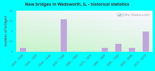
- New bridges - historical statistics
- 11920-1929
- 81950-1959
- 11980-1989
- 21990-1999
- 12000-2009
- 52010-2019

- Reconstructed bridges - Historical Statistics
- 21980-1989
- 01990-1999
- 12000-2009


- Bridge Condition - Deck
- 50.0%Good
- 50.0%Satisfactory

- Bridge Condition - Superstructure
- 36.4%Very good
- 27.3%Good
- 9.1%Satisfactory
- 27.3%Fair

- Bridge Condition - Substructure
- 27.3%Very good
- 63.6%Good
- 9.1%Satisfactory

- Bridge Condition - Channel
- 62.5%Very good
- 12.5%Good
- 25.0%Satisfactory

- Bridge Condition - Culverts
- 50.0%Good
- 50.0%Satisfactory
Find on map >> Show street view
Structure Number: 490028, Location: 3.5 M N OF GURNEE (Lat: 42.418631, Lng: -87.938044), Route carried "on" structure: US 41, Year Built: 1951, Year Reconstructed: 1989, Status: Open, Structure Length: 1.46m (4.79ft), Average Daily Traffic: 23,000 (year 2021), Truck Traffic: 11%, Average Future Daily Traffic: 39,623 (year 2032), Design Load: HS 20, Features Intersected: MILL CREEK
Minimum Vertical Clearance: 30+ m (98+ ft), Kilometerpoint: 93.999, Lanes on structure: 4, Base Highway Network: Yes, Owner: State Highway Agency, Approaching Roadway Width: 21.9m (71.9ft), Skew: 20 degrees, Material/Design: Steel, Design/Construction: Stringer/Multi-beam, Number Of Spans In Main Unit: 1, Length of Maximum Span: 13.4m (44.0ft), Curb-To-Curb Width: 29.6m (97.1ft), Out-to-Out Width: 32.1m (105.3ft)
Condition: Deck: Satisfactory, Superstructure: Good, Substructure: Good, Channel: Satisfactory, Operating Rating: 85.2 metric tons, Method Used To Determine Operating Rating: Load Factor (LF) rating reported by rating factor (RF) method using MS18 loading, Inventory Rating: 51.2 metric tons, Method Used To Determine Inventory Rating: Load Factor (LF) rating reported by rating factor (RF) method using MS18 loading, Structural Evaluation: Better than present minimum criteria, Deck Geometry: Superior to present desirable criteria, Waterway Adequacy: Equal to present minimum criteria, Approach Roadway Alignment: Equal to present desirable criteria, Designated Inspection Frequency: Every 24 months, Other Special Inspection Frequency: Every 24 months, Inspection Date: September 2021, Other Special Inspection Date: September 2021, Deck Structure Type: Concrete Cast-file-Place, Wearing Surface/Protective System: Deck Protection: Epoxy Coated Reinforcing
Find on map >> Show street view
Structure Number: 490059, Location: 0.2 M E OF US 41 (Lat: 42.465356, Lng: -87.942883), Route carried "on" structure: State highway 173, Year Built: 1929, Year Reconstructed: 2011, Status: Open, Structure Length: 3.47m (11.38ft), Average Daily Traffic: 10,400 (year 2021), Truck Traffic: 5%, Average Future Daily Traffic: 12,577 (year 2032), Design Load: HS 20, Features Intersected: DES PLAINES RIVER
Minimum Vertical Clearance: 30+ m (98+ ft), Kilometerpoint: 96.558, Lanes on structure: 2, Base Highway Network: Yes, Owner: State Highway Agency, Approaching Roadway Width: 12.2m (40.0ft), Material/Design: Prestressed concrete, Design/Construction: Box Beam or Girders - Multiple, Number Of Spans In Main Unit: 3, Length of Maximum Span: 11.6m (38.1ft), Curb-To-Curb Width: 12.1m (39.7ft), Out-to-Out Width: 12.5m (41.0ft)
Condition: Deck: Good, Superstructure: Good, Substructure: Good, Channel: Good, Operating Rating: 63.2 metric tons, Method Used To Determine Operating Rating: Load and Resistance Factor Rating (LRFR) rating reported by rating factor(RF) method using HL-93 loadings, Inventory Rating: 48.6 metric tons, Method Used To Determine Inventory Rating: Load and Resistance Factor Rating (LRFR) rating reported by rating factor(RF) method using HL-93 loadings, Structural Evaluation: Better than present minimum criteria, Deck Geometry: Somewhat better than minimum adequacy, Waterway Adequacy: Better than present minimum criteria, Approach Roadway Alignment: Better than present minimum criteria, Designated Inspection Frequency: Every 48 months, Inspection Date: July 2021, Deck Structure Type: Concrete Cast-file-Place, Wearing Surface/Protective System: Wearing Surface: Integral Concrete, Deck Protection: Epoxy Coated Reinforcing
Find on map >> Show street view
Structure Number: 490094, Location: US 41 SB 1M N IL-173 (Lat: 42.479628, Lng: -87.948308), Route carried "on" structure: Interstate 94, Year Built: 1958, Status: Open, Structure Length: 6.19m (20.31ft), Average Daily Traffic: 32,200 (year 2021), Truck Traffic: 27%, Average Future Daily Traffic: 30,107 (year 2032), Design Load: HS 20, Features Intersected: US 41 SB (SKOKIE HY)
Minimum Vertical Clearance: 30+ m (98+ ft), Kilometerpoint: 1.754, Lanes on structure: 2, Lanes under structure: 2, Base Highway Network: Yes, Owner: State Toll Authority, Approaching Roadway Width: 11.0m (36.1ft), Skew: 5 degrees, Material/Design: Prestressed concrete, Design/Construction: Stringer/Multi-beam, Number Of Spans In Main Unit: 3, Length of Maximum Span: 21.6m (70.9ft), Curb-To-Curb Width: 10.5m (34.4ft), Out-to-Out Width: 18.6m (61.0ft)
Condition: Deck: Good, Superstructure: Good, Substructure: Good, Operating Rating: 94.3 metric tons, Method Used To Determine Operating Rating: Load Factor (LF) rating reported by rating factor (RF) method using MS18 loading, Inventory Rating: 56.4 metric tons, Method Used To Determine Inventory Rating: Load Factor (LF) rating reported by rating factor (RF) method using MS18 loading, Structural Evaluation: Better than present minimum criteria, Deck Geometry: Meets minimum limits, Underclear: High priority of corrective action, Approach Roadway Alignment: Superior to present desirable criteria, Length Of Structure Improvement: 6.19m (20.31ft), Designated Inspection Frequency: Every 24 months, Inspection Date: May 2019, Bridge Improvement Cost: $780,000, Roadway Improvement Cost: $78,000, Total Project Cost: $1,170,000, Deck Structure Type: Concrete Cast-file-Place, Wearing Surface/Protective System: Wearing Surface: Bituminous
Find on map >> Show street view
Structure Number: 490184, Location: S OF MILL CREEK (Lat: 42.418342, Lng: -87.938042), Route carried "on" structure: US 41, Year Built: 1999, Status: Open, Structure Length: 1.73m (5.68ft), Average Daily Traffic: 23,000 (year 2021), Truck Traffic: 11%, Average Future Daily Traffic: 39,623 (year 2032), Features Intersected: CREEK
Minimum Vertical Clearance: 30+ m (98+ ft), Kilometerpoint: 93.967, Lanes on structure: 4, Base Highway Network: Yes, Owner: State Highway Agency, Approaching Roadway Width: 30.8m (101.0ft), Material/Design: Concrete, Design/Construction: Culvert, Number Of Spans In Main Unit: 4, Length of Maximum Span: 3.7m (12.1ft), Curb-To-Curb Width: 30.8m (101.0ft), Out-to-Out Width: 32.7m (107.3ft)
Condition: Channel: Very good, Culverts: Satisfactory, Operating Rating: 83.3 metric tons, Method Used To Determine Operating Rating: Load Factor (LF) rating reported by rating factor (RF) method using MS18 loading, Inventory Rating: 49.9 metric tons, Method Used To Determine Inventory Rating: Load Factor (LF) rating reported by rating factor (RF) method using MS18 loading, Structural Evaluation: Equal to present minimum criteria, Deck Geometry: Superior to present desirable criteria, Waterway Adequacy: Equal to present desirable criteria, Approach Roadway Alignment: Equal to present desirable criteria, Designated Inspection Frequency: Every 24 months, Inspection Date: September 2021, Deck Structure Type: Concrete Cast-file-Place
Find on map >> Show street view
Structure Number: 490533, Location: 1.7 M N IL 173 (Lat: 42.487175, Lng: -87.948147), Route carried "on" structure: Other road , Year Built: 2012, Status: Open, Structure Length: 3.76m (12.34ft), Average Daily Traffic: 4,900 (year 2019), Truck Traffic: 23%, Average Future Daily Traffic: 6,200 (year 2032), Design Load: HS 25 or greater, Features Intersected: I- 94 SB TRI STATE, Facility Carried by Structure: RUSSELL RD
Minimum Vertical Clearance: 30+ m (98+ ft), Kilometerpoint: 0.354, Lanes on structure: 4, Lanes under structure: 3, Base Highway Network: Yes, Owner: State Highway Agency, Approaching Roadway Width: 14.6m (47.9ft), Skew: 30 degrees, Material/Design: Steel, Design/Construction: Stringer/Multi-beam, Number Of Spans In Main Unit: 1, Length of Maximum Span: 35.7m (117.1ft), Curb or Sidewalk Widths: Left: 0.0m, Right: 4.3m (14.1ft), Curb-To-Curb Width: 16.8m (55.1ft), Out-to-Out Width: 25.6m (84.0ft)
Condition: Deck: Good, Superstructure: Very good, Substructure: Very good, Operating Rating: 81.0 metric tons, Method Used To Determine Operating Rating: Load and Resistance Factor Rating (LRFR) rating reported by rating factor(RF) method using HL-93 loadings, Inventory Rating: 62.5 metric tons, Method Used To Determine Inventory Rating: Load and Resistance Factor Rating (LRFR) rating reported by rating factor(RF) method using HL-93 loadings, Structural Evaluation: Equal to present desirable criteria, Deck Geometry: Somewhat better than minimum adequacy, Approach Roadway Alignment: Equal to present desirable criteria, Designated Inspection Frequency: Every 24 months, Inspection Date: October 2020, Deck Structure Type: Concrete Cast-file-Place, Wearing Surface/Protective System: Deck Protection: Epoxy Coated Reinforcing
Find on map >> Show street view
Structure Number: 490534, Location: 1.7 M N IL 173 (Lat: 42.487172, Lng: -87.947708), Route carried "on" structure: Other road , Year Built: 2012, Status: Open, Structure Length: 4.19m (13.75ft), Average Daily Traffic: 4,900 (year 2019), Truck Traffic: 23%, Average Future Daily Traffic: 6,200 (year 2037), Design Load: HS 25 or greater, Features Intersected: I- 94 NB (TRI STATE), Facility Carried by Structure: RUSSELL RD
Minimum Vertical Clearance: 30+ m (98+ ft), Kilometerpoint: 0.402, Lanes on structure: 4, Lanes under structure: 3, Base Highway Network: Yes, Owner: State Highway Agency, Approaching Roadway Width: 19.1m (62.7ft), Skew: 31 degrees, Material/Design: Steel, Design/Construction: Stringer/Multi-beam, Number Of Spans In Main Unit: 1, Length of Maximum Span: 39.9m (130.9ft), Curb or Sidewalk Widths: Left: 0.0m, Right: 4.3m (14.1ft), Curb-To-Curb Width: 19.1m (62.7ft), Out-to-Out Width: 25.6m (84.0ft)
Condition: Deck: Good, Superstructure: Very good, Substructure: Very good, Operating Rating: 68.0 metric tons, Method Used To Determine Operating Rating: Load and Resistance Factor Rating (LRFR) rating reported by rating factor(RF) method using HL-93 loadings, Inventory Rating: 52.5 metric tons, Method Used To Determine Inventory Rating: Load and Resistance Factor Rating (LRFR) rating reported by rating factor(RF) method using HL-93 loadings, Structural Evaluation: Equal to present desirable criteria, Deck Geometry: Equal to present minimum criteria, Approach Roadway Alignment: Equal to present desirable criteria, Designated Inspection Frequency: Every 24 months, Inspection Date: October 2020, Deck Structure Type: Concrete Cast-file-Place, Wearing Surface/Protective System: Deck Protection: Epoxy Coated Reinforcing
Find on map >> Show street view
Structure Number: 493056, Location: 0.25M.E.OF US-41 (Lat: 42.428853, Lng: -87.930381), Route carried "on" structure: Other road , Year Built: 1987, Status: Open, Structure Length: 5.41m (17.75ft), Average Daily Traffic: 13,000 (year 2019), Truck Traffic: 4%, Average Future Daily Traffic: 15,359 (year 2032), Design Load: HS 20, Features Intersected: DESPLAINES RIVER, Facility Carried by Structure: WADSWORTH RD.
Minimum Vertical Clearance: 30+ m (98+ ft), Kilometerpoint: 3.428, Lanes on structure: 2, Base Highway Network: Yes, Owner: County Highway Agency, Approaching Roadway Width: 12.2m (40.0ft), Skew: 3 degrees, Material/Design: Prestressed concrete continuous, Design/Construction: Stringer/Multi-beam, Number Of Spans In Main Unit: 3, Length of Maximum Span: 19.2m (63.0ft), Curb-To-Curb Width: 12.2m (40.0ft), Out-to-Out Width: 13.2m (43.3ft)
Condition: Deck: Good, Superstructure: Very good, Substructure: Good, Channel: Very good, Operating Rating: 44.4 metric tons, Method Used To Determine Operating Rating: Assigned rating based on Load Factor Design (LFD) reported by rating factor (RF) using MS18 loading, Inventory Rating: 32.4 metric tons, Method Used To Determine Inventory Rating: Assigned rating based on Load Factor Design (LFD) reported by rating factor (RF) using MS18 loading, Structural Evaluation: Better than present minimum criteria, Deck Geometry: Somewhat better than minimum adequacy, Waterway Adequacy: Equal to present desirable criteria, Approach Roadway Alignment: Equal to present desirable criteria, Designated Inspection Frequency: Every 48 months, Inspection Date: April 2020, Deck Structure Type: Concrete Cast-file-Place, Wearing Surface/Protective System: Deck Protection: Epoxy Coated Reinforcing
Find on map >> Show street view
Structure Number: 49308, Location: .13 E OF TOLL RD (Lat: 42.418472, Lng: -87.945158), Route carried "on" structure: Other road , Year Built: 2002, Status: Open, Structure Length: 2.47m (8.10ft), Average Daily Traffic: 6,300 (year 2019), Truck Traffic: 5%, Average Future Daily Traffic: 8,181 (year 2032), Design Load: HS 20, Features Intersected: MILL CREEK, Facility Carried by Structure: DILLEYS ROAD
Minimum Vertical Clearance: 30+ m (98+ ft), Kilometerpoint: 1.191, Lanes on structure: 2, Base Highway Network: Yes, Owner: County Highway Agency, Approaching Roadway Width: 12.2m (40.0ft), Material/Design: Prestressed concrete, Design/Construction: Box Beam or Girders - Multiple, Number Of Spans In Main Unit: 1, Length of Maximum Span: 23.1m (75.8ft), Curb-To-Curb Width: 12.2m (40.0ft), Out-to-Out Width: 13.1m (43.0ft)
Condition: Deck: Satisfactory, Superstructure: Satisfactory, Substructure: Good, Channel: Very good, Operating Rating: 64.5 metric tons, Method Used To Determine Operating Rating: Load Factor (LF) rating reported by rating factor (RF) method using MS18 loading, Inventory Rating: 38.6 metric tons, Method Used To Determine Inventory Rating: Load Factor (LF) rating reported by rating factor (RF) method using MS18 loading, Structural Evaluation: Equal to present minimum criteria, Deck Geometry: Somewhat better than minimum adequacy, Waterway Adequacy: Equal to present desirable criteria, Approach Roadway Alignment: Equal to present desirable criteria, Designated Inspection Frequency: Every 24 months, Inspection Date: April 2020, Deck Structure Type: Concrete Precast Panels, Wearing Surface/Protective System: Deck Protection: Epoxy Coated Reinforcing
Find on map >> Show street view
Structure Number: 495005, Location: 0.7M S OF STATE LINE (Lat: 42.483228, Lng: -87.912811), Route carried "on" structure: Other road , Year Built: 1954, Year Reconstructed: 1993, Status: Open, Structure Length: 0.86m (2.82ft), Average Daily Traffic: 2,900 (year 2019), Truck Traffic: 13%, Average Future Daily Traffic: 3,005 (year 2032), Design Load: HS 20, Features Intersected: DES PLAINES TRIB., Facility Carried by Structure: KILBOURNE RD
Minimum Vertical Clearance: 30+ m (98+ ft), Kilometerpoint: 1.207, Lanes on structure: 2, Base Highway Network: Yes, Owner: County Highway Agency, Approaching Roadway Width: 12.2m (40.0ft), Skew: 1 degrees, Material/Design: Concrete, Design/Construction: Culvert, Number Of Spans In Main Unit: 3, Length of Maximum Span: 2.0m (6.6ft)
Condition: Channel: Very good, Culverts: Good, Operating Rating: 53.8 metric tons, Method Used To Determine Operating Rating: Field evaluation and documented engineering judgment, Inventory Rating: 32.4 metric tons, Method Used To Determine Inventory Rating: Field evaluation and documented engineering judgment, Structural Evaluation: Better than present minimum criteria, Waterway Adequacy: Equal to present desirable criteria, Approach Roadway Alignment: Equal to present desirable criteria, Designated Inspection Frequency: Every 24 months, Inspection Date: January 2022
Find on map >> Show street view
Structure Number: 49605, Location: 0.15 M W of CHY W26 (Lat: 42.436772, Lng: -87.916717), Route carried "on" structure: City street , Year Built: 2011, Status: Open, Structure Length: 1.22m (4.00ft), Average Daily Traffic: 35 (year 2015), Truck Traffic: 9%, Average Future Daily Traffic: 1,000 (year 2032), Design Load: HS 25 or greater, Features Intersected: Unnamed Creek, Facility Carried by Structure: W. Concord Court
Minimum Vertical Clearance: 30+ m (98+ ft), Kilometerpoint: 0.483, Lanes on structure: 2, Owner: Private, Approaching Roadway Width: 6.7m (22.0ft), Material/Design: Concrete, Design/Construction: Frame, Length of Maximum Span: 12.2m (40.0ft), Curb-To-Curb Width: 7.3m (24.0ft), Out-to-Out Width: 9.8m (32.2ft)
Condition: Superstructure: Very good, Substructure: Very good, Channel: Very good, Operating Rating: 44.1 metric tons, Method Used To Determine Operating Rating: Assigned rating based on Load Factor Design (LFD) reported by rating factor (RF) using MS18 loading, Inventory Rating: 32.4 metric tons, Method Used To Determine Inventory Rating: Assigned rating based on Load Factor Design (LFD) reported by rating factor (RF) using MS18 loading, Structural Evaluation: Equal to present desirable criteria, Deck Geometry: Equal to present minimum criteria, Waterway Adequacy: Superior to present desirable criteria, Approach Roadway Alignment: Equal to present desirable criteria, Designated Inspection Frequency: Every 48 months, Inspection Date: July 2020, Deck Structure Type: Concrete Precast Panels, Wearing Surface/Protective System: Wearing Surface: Bituminous, Membrane: Built-up
Find on map >> Show street view
Structure Number: 499, Location: 0.19 MI N IL 173 (Lat: 42.468322, Lng: -87.943125), Route carried "on" structure: County highway , Year Built: 1991, Status: Open, Structure Length: 4.40m (14.44ft), Average Daily Traffic: 300 (year 2019), Truck Traffic: 7%, Average Future Daily Traffic: 195 (year 2032), Design Load: H 15, Features Intersected: DESPLAINES RIVER, Facility Carried by Structure: VANPATTEN WOODS RO
Minimum Vertical Clearance: 30+ m (98+ ft), Kilometerpoint: 2.012, Lanes on structure: 2, Owner: Private, Approaching Roadway Width: 7.9m (25.9ft), Material/Design: Prestressed concrete, Design/Construction: Box Beam or Girders - Multiple, Number Of Spans In Main Unit: 3, Length of Maximum Span: 14.2m (46.6ft), Curb-To-Curb Width: 9.3m (30.5ft), Out-to-Out Width: 10.4m (34.1ft)
Condition: Deck: Satisfactory, Superstructure: Fair, Substructure: Good, Channel: Satisfactory, Operating Rating: 44.1 metric tons, Method Used To Determine Operating Rating: Assigned rating based on Load Factor Design (LFD) reported by rating factor (RF) using MS18 loading, Inventory Rating: 32.4 metric tons, Method Used To Determine Inventory Rating: Assigned rating based on Load Factor Design (LFD) reported by rating factor (RF) using MS18 loading, Structural Evaluation: Somewhat better than minimum adequacy, Deck Geometry: Equal to present minimum criteria, Waterway Adequacy: Superior to present desirable criteria, Approach Roadway Alignment: Equal to present desirable criteria, Designated Inspection Frequency: Every 24 months, Inspection Date: December 2021, Deck Structure Type: Concrete Precast Panels, Wearing Surface/Protective System: Wearing Surface: Bituminous, Membrane: Built-up, Deck Protection: Epoxy Coated Reinforcing
Find on map >> Show street view
Structure Number: 499915, Location: I94 1.2M N ILL 173 (Lat: 42.477814, Lng: -87.950181), Route carried "on" structure: Interstate 94, Year Built: 1958, Status: Open, Structure Length: 3.90m (12.80ft), Average Daily Traffic: 32,200 (year 2021), Truck Traffic: 27%, Average Future Daily Traffic: 30,107 (year 2032), Design Load: HS 20, Features Intersected: OLD SKOKIE HWY
Minimum Vertical Clearance: 30+ m (98+ ft), Kilometerpoint: 2.012, Lanes on structure: 2, Lanes under structure: 2, Base Highway Network: Yes, Toll: On toll road, Owner: State Toll Authority, Approaching Roadway Width: 12.2m (40.0ft), Material/Design: Prestressed concrete, Design/Construction: Stringer/Multi-beam, Number Of Spans In Main Unit: 3, Length of Maximum Span: 12.8m (42.0ft), Curb-To-Curb Width: 10.5m (34.4ft), Out-to-Out Width: 12.0m (39.4ft)
Condition: Deck: Satisfactory, Superstructure: Fair, Substructure: Satisfactory, Operating Rating: 62.9 metric tons, Method Used To Determine Operating Rating: Load Factor (LF) rating reported by rating factor (RF) method using MS18 loading, Inventory Rating: 37.6 metric tons, Method Used To Determine Inventory Rating: Load Factor (LF) rating reported by rating factor (RF) method using MS18 loading, Structural Evaluation: Somewhat better than minimum adequacy, Deck Geometry: Meets minimum limits, Underclear: Meets minimum limits, Approach Roadway Alignment: Equal to present minimum criteria, Designated Inspection Frequency: Every 24 months, Inspection Date: May 2019, Deck Structure Type: Concrete Cast-file-Place, Wearing Surface/Protective System: Wearing Surface: Bituminous
Find on map >> Show street view
Structure Number: 499916, Location: I94 1.2M N ILL 173 (Lat: 42.477717, Lng: -87.950353), Route carried "on" structure: Interstate 94, Year Built: 1958, Status: Open, Structure Length: 3.90m (12.80ft), Average Daily Traffic: 32,200 (year 2021), Truck Traffic: 27%, Average Future Daily Traffic: 30,107 (year 2032), Design Load: HS 20, Features Intersected: OLD SKOKIE HWY
Minimum Vertical Clearance: 30+ m (98+ ft), Kilometerpoint: 2.028, Lanes on structure: 2, Lanes under structure: 2, Base Highway Network: Yes, Toll: On toll road, Owner: State Toll Authority, Approaching Roadway Width: 12.2m (40.0ft), Material/Design: Prestressed concrete, Design/Construction: Stringer/Multi-beam, Number Of Spans In Main Unit: 3, Length of Maximum Span: 12.8m (42.0ft), Curb-To-Curb Width: 10.5m (34.4ft), Out-to-Out Width: 12.0m (39.4ft)
Condition: Deck: Satisfactory, Superstructure: Fair, Substructure: Good, Operating Rating: 63.8 metric tons, Method Used To Determine Operating Rating: Load Factor (LF) rating reported by rating factor (RF) method using MS18 loading, Inventory Rating: 38.2 metric tons, Method Used To Determine Inventory Rating: Load Factor (LF) rating reported by rating factor (RF) method using MS18 loading, Structural Evaluation: Somewhat better than minimum adequacy, Deck Geometry: Meets minimum limits, Underclear: Meets minimum limits, Approach Roadway Alignment: Equal to present minimum criteria, Designated Inspection Frequency: Every 24 months, Inspection Date: May 2019, Deck Structure Type: Concrete Cast-file-Place, Wearing Surface/Protective System: Wearing Surface: Bituminous
Find on map >> Show street view
Structure Number: 490094, Location: US 41 SB 1M N IL-173 (Lat: 42.479178, Lng: -87.947672), Route carried "under" structure: US 41, Year Built: 1958, Structure Length: 0. m, Average Daily Traffic: 21,500 (year 2021), Truck Traffic: 11%, Features Intersected: US 41 SB (SKOKIE HY), Facility Carried by Structure: I-94 NB
Minimum Vertical Clearance: 5.16m (16.93ft), Kilometerpoint: 100.919, Lanes on structure: 2, Lanes under structure: 2, Material/Design: Prestressed concrete, Design/Construction: Stringer/Multi-beam, Length of Maximum Span: 21.6m (70.9ft)
Find on map >> Show street view
Structure Number: 490533, Location: 1.7 M N IL 173 (Lat: 42.487172, Lng: -87.947564), Route carried "under" structure: Interstate 94, Year Built: 2012, Structure Length: 0. m, Average Daily Traffic: 84,700 (year 2021), Truck Traffic: 21%, Features Intersected: I- 94 SB TRI STATE, Facility Carried by Structure: RUSSELL RD
Minimum Vertical Clearance: 5.69m (18.67ft), Kilometerpoint: 0.901, Lanes on structure: 4, Lanes under structure: 3, Material/Design: Steel, Design/Construction: Stringer/Multi-beam, Length of Maximum Span: 35.7m (117.1ft)
Find on map >> Show street view
Structure Number: 490534, Location: 1.7 M N IL 173 (Lat: 42.487172, Lng: -87.947564), Route carried "under" structure: Interstate 94, Year Built: 2012, Structure Length: 0. m, Average Daily Traffic: 84,700 (year 2021), Truck Traffic: 21%, Features Intersected: I- 94 NB (TRI STATE), Facility Carried by Structure: RUSSELL RD
Minimum Vertical Clearance: 5.21m (17.09ft), Kilometerpoint: 0.901, Lanes on structure: 4, Lanes under structure: 3, Material/Design: Steel, Design/Construction: Stringer/Multi-beam, Length of Maximum Span: 39.9m (130.9ft)
Find on map >> Show street view
Structure Number: 499915, Location: I94 1.2M N ILL 173 (Lat: 42.477889, Lng: -87.950253), Route carried "under" structure: Other road , Year Built: 1958, Structure Length: 0. m, Average Daily Traffic: 1,375 (year 2019), Truck Traffic: 12%, Features Intersected: OLD SKOKIE HWY, Facility Carried by Structure: I-94 SB
Minimum Vertical Clearance: 4.42m (14.50ft), Kilometerpoint: 1.915, Lanes on structure: 2, Lanes under structure: 2, Toll: On toll road, Material/Design: Prestressed concrete, Design/Construction: Stringer/Multi-beam, Length of Maximum Span: 12.8m (42.0ft)
Find on map >> Show street view
Structure Number: 499916, Location: I94 1.2M N ILL 173 (Lat: 42.477542, Lng: -87.949933), Route carried "under" structure: Other road , Year Built: 1958, Structure Length: 0. m, Average Daily Traffic: 1,375 (year 2019), Truck Traffic: 12%, Features Intersected: OLD SKOKIE HWY, Facility Carried by Structure: I-94 NB
Minimum Vertical Clearance: 4.45m (14.60ft), Kilometerpoint: 1.947, Lanes on structure: 2, Lanes under structure: 2, Toll: On toll road, Material/Design: Prestressed concrete, Design/Construction: Stringer/Multi-beam, Length of Maximum Span: 12.8m (42.0ft)