Bridge Statistics for Wagner, South Dakota (SD)
Condition, Traffic, Stress, Structural Evaluation, Project Costs
- National Bridge Inventory (NBI) Statistics
- 12Number of bridges
- 79ft / 23.8mTotal length
- $2,948,000Total costs
- 8,694Total average daily traffic
- 817Total average daily truck traffic
- 11,955Total future (year 2032) average daily traffic
- National Bridge Inventory (NBI) Registered Bridges for Wagner
- No street view available for this location
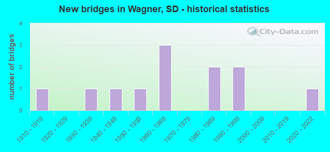
- New bridges - historical statistics
- 11910-1919
- 11930-1939
- 11940-1949
- 11950-1959
- 31960-1969
- 21980-1989
- 21990-1999
- 12020-2022

- Bridge Condition - Deck
- 50.0%Good
- 12.5%Satisfactory
- 37.5%Fair

- Bridge Condition - Superstructure
- 12.5%Very good
- 37.5%Good
- 12.5%Satisfactory
- 37.5%Fair

- Bridge Condition - Substructure
- 25.0%Good
- 50.0%Satisfactory
- 25.0%Poor

- Bridge Condition - Channel
- 16.7%Very good
- 58.3%Good
- 25.0%Satisfactory

- Bridge Condition - Culverts
- 25.0%Very good
- 25.0%Good
- 50.0%Satisfactory
Find on map >> Show street view
Structure Number: 12480286, Location: 0.4 N JCT SD46 (Lat: 43.087989, Lng: -98.347589), Route carried "on" structure: State highway 50, Year Built: 2020, Status: Open, Structure Length: 0.69m (2.26ft), Average Daily Traffic: 1,329 (year 2020), Truck Traffic: 9%, Average Future Daily Traffic: 1,908 (year 2040), Design Load: HL 93, Features Intersected: TRIB CHOTEAU CK
Minimum Vertical Clearance: 30+ m (98+ ft), Kilometerpoint: 526.931, Lanes on structure: 2, Owner: State Highway Agency, Approaching Roadway Width: 12.2m (40.0ft), Material/Design: Concrete, Design/Construction: Culvert, Number Of Spans In Main Unit: 2, Length of Maximum Span: 3.4m (11.2ft)
Condition: Channel: Very good, Culverts: Very good, Operating Rating: 49.9 metric tons, Method Used To Determine Operating Rating: Load and Resistance Factor (LRFR), Inventory Rating: 38.5 metric tons, Method Used To Determine Inventory Rating: Load and Resistance Factor (LRFR), Structural Evaluation: Equal to present desirable criteria, Waterway Adequacy: Superior to present desirable criteria, Approach Roadway Alignment: Superior to present desirable criteria, Designated Inspection Frequency: Every 48 months, Inspection Date: October 2020
Find on map >> Show street view
Structure Number: 1249626, Location: 3.0N & 1.4W of Wagner (Lat: 43.125239, Lng: -98.315386), Route carried "on" structure: Other road , Year Built: 1986, Status: Open, Structure Length: 1.98m (6.50ft), Average Daily Traffic: 48 (year 2019), Truck Traffic: 2%, Average Future Daily Traffic: 48 (year 2032), Design Load: HS 20, Features Intersected: Choteau Creek, Facility Carried by Structure: 39360 294th Street
Minimum Vertical Clearance: 30+ m (98+ ft), Kilometerpoint: 0.000, Lanes on structure: 2, Owner: County Highway Agency, Approaching Roadway Width: 6.4m (21.0ft), Material/Design: Prestressed concrete, Design/Construction: Tee Beam, Number Of Spans In Main Unit: 1, Length of Maximum Span: 19.5m (64.0ft), Curb-To-Curb Width: 8.0m (26.2ft), Out-to-Out Width: 8.2m (26.9ft)
Condition: Deck: Good, Superstructure: Good, Substructure: Satisfactory, Channel: Very good, Operating Rating: 32.7 metric tons, Method Used To Determine Operating Rating: Field evaluation and documented engineering judgment, Inventory Rating: 24.5 metric tons, Method Used To Determine Inventory Rating: Field evaluation and documented engineering judgment, Structural Evaluation: Equal to present minimum criteria, Deck Geometry: Equal to present minimum criteria, Waterway Adequacy: Better than present minimum criteria, Approach Roadway Alignment: Equal to present desirable criteria, Designated Inspection Frequency: Every 24 months, Inspection Date: August 2021, Deck Structure Type: Concrete Precast Panels, Wearing Surface/Protective System: Wearing Surface: Gravel
Find on map >> Show street view
Structure Number: 1249727, Location: 2.0N & 1.3W of Wagner (Lat: 43.110803, Lng: -98.312547), Route carried "on" structure: Other road , Year Built: 1998, Status: Open, Structure Length: 2.77m (9.09ft), Average Daily Traffic: 48 (year 2019), Truck Traffic: 2%, Average Future Daily Traffic: 48 (year 2032), Design Load: HL 93, Features Intersected: Choteau Creek, Facility Carried by Structure: 39370 295th Street
Minimum Vertical Clearance: 30+ m (98+ ft), Kilometerpoint: 0.000, Lanes on structure: 2, Owner: County Highway Agency, Approaching Roadway Width: 5.5m (18.0ft), Skew: 2 degrees, Material/Design: Prestressed concrete, Design/Construction: Stringer/Multi-beam, Number Of Spans In Main Unit: 1, Length of Maximum Span: 27.1m (88.9ft), Curb or Sidewalk Widths: Left: 0.4m (1.3ft), Right: 0.4m (1.3ft), Curb-To-Curb Width: 8.5m (27.9ft), Out-to-Out Width: 9.3m (30.5ft)
Condition: Deck: Satisfactory, Superstructure: Very good, Substructure: Good, Channel: Good, Operating Rating: 50.5 metric tons, Method Used To Determine Operating Rating: Load and Resistance Factor (LRFR), Inventory Rating: 31.0 metric tons, Method Used To Determine Inventory Rating: Load and Resistance Factor (LRFR), Structural Evaluation: Better than present minimum criteria, Deck Geometry: Better than present minimum criteria, Waterway Adequacy: Equal to present minimum criteria, Approach Roadway Alignment: Equal to present desirable criteria, Designated Inspection Frequency: Every 24 months, Inspection Date: August 2021, Deck Structure Type: Concrete Cast-file-Place, Wearing Surface/Protective System: Wearing Surface: Monolithic Concrete
Find on map >> Show street view
Structure Number: 12500288, Location: 1.0 NW OF WAGNER (Lat: 43.084861, Lng: -98.308469), Route carried "on" structure: County highway , Year Built: 1940, Status: Open, Structure Length: 0.62m (2.03ft), Average Daily Traffic: 1,329 (year 2019), Truck Traffic: 9%, Average Future Daily Traffic: 1,908 (year 2039), Design Load: H 15, Features Intersected: CK, Facility Carried by Structure: Old IRR SD050
Minimum Vertical Clearance: 30+ m (98+ ft), Kilometerpoint: 529.136, Lanes on structure: 2, Owner: County Highway Agency, Approaching Roadway Width: 8.5m (27.9ft), Material/Design: Concrete continuous, Design/Construction: Culvert, Number Of Spans In Main Unit: 2, Length of Maximum Span: 3.0m (9.8ft)
Condition: Channel: Satisfactory, Culverts: Satisfactory, Operating Rating: 32.7 metric tons, Method Used To Determine Operating Rating: Field evaluation and documented engineering judgment, Inventory Rating: 25.1 metric tons, Method Used To Determine Inventory Rating: Field evaluation and documented engineering judgment, Structural Evaluation: Equal to present minimum criteria, Waterway Adequacy: Equal to present desirable criteria, Approach Roadway Alignment: Equal to present desirable criteria, Designated Inspection Frequency: Every 48 months, Underwater Inspection Frequency: Every 60 months, Inspection Date: October 2020, Underwater Inspection Date: August 2018
Find on map >> Show street view
Structure Number: 12510279, Location: 1.1N of Wagner (Lat: 43.097750, Lng: -98.288119), Route carried "on" structure: County highway , Year Built: 1955, Status: Posted for load, Structure Length: 5.07m (16.63ft), Average Daily Traffic: 564 (year 2019), Truck Traffic: 3%, Average Future Daily Traffic: 564 (year 2032), Design Load: H 15, Features Intersected: Choteau Creek, Facility Carried by Structure: 29490 395th Avenue
Minimum Vertical Clearance: 30+ m (98+ ft), Kilometerpoint: 0.000, Lanes on structure: 2, Owner: County Highway Agency, Approaching Roadway Width: 8.5m (27.9ft), Material/Design: Steel, Design/Construction: Stringer/Multi-beam, Number Of Spans In Main Unit: 3, Length of Maximum Span: 19.5m (64.0ft), Curb-To-Curb Width: 7.3m (24.0ft), Out-to-Out Width: 8.0m (26.2ft)
Condition: Deck: Fair, Superstructure: Satisfactory, Substructure: Satisfactory, Channel: Good, Operating Rating: 29.0 metric tons, Method Used To Determine Operating Rating: Load Factor (LF), Inventory Rating: 17.3 metric tons, Method Used To Determine Inventory Rating: Load Factor (LF), Structural Evaluation: Meets minimum limits, Deck Geometry: Meets minimum limits, Waterway Adequacy: Better than present minimum criteria, Approach Roadway Alignment: Equal to present desirable criteria, Bridge Posting: Required (Relationship of Operating Rating to Maximum Legal Load: 20.0 - 29.9% below), Length Of Structure Improvement: 5.18m (16.99ft), Designated Inspection Frequency: Every 24 months, Inspection Date: August 2021, Bridge Improvement Cost: $1,847,000, Roadway Improvement Cost: $30,000, Total Project Cost: $1,877,000 ( Estimate for 2019), Deck Structure Type: Concrete Cast-file-Place, Wearing Surface/Protective System: Wearing Surface: Monolithic Concrete
Find on map >> Show street view
Structure Number: 12510286, Location: 0.4N of Wagner (Lat: 43.087881, Lng: -98.288117), Route carried "on" structure: County highway , Year Built: 1991, Status: Open, Structure Length: 0.93m (3.05ft), Average Daily Traffic: 564 (year 2019), Truck Traffic: 1%, Average Future Daily Traffic: 600 (year 2032), Features Intersected: Creek, Facility Carried by Structure: 29660 395th Avenue
Minimum Vertical Clearance: 30+ m (98+ ft), Kilometerpoint: 0.000, Lanes on structure: 2, Owner: County Highway Agency, Approaching Roadway Width: 8.2m (26.9ft), Material/Design: Prestressed concrete, Design/Construction: Tee Beam, Number Of Spans In Main Unit: 1, Length of Maximum Span: 8.8m (28.9ft), Curb-To-Curb Width: 9.3m (30.5ft), Out-to-Out Width: 9.6m (31.5ft)
Condition: Deck: Good, Superstructure: Fair, Substructure: Satisfactory, Channel: Good, Operating Rating: 32.7 metric tons, Method Used To Determine Operating Rating: Field evaluation and documented engineering judgment, Inventory Rating: 24.5 metric tons, Method Used To Determine Inventory Rating: Field evaluation and documented engineering judgment, Structural Evaluation: Somewhat better than minimum adequacy, Deck Geometry: Equal to present minimum criteria, Waterway Adequacy: Better than present minimum criteria, Approach Roadway Alignment: Equal to present desirable criteria, Designated Inspection Frequency: Every 24 months, Inspection Date: August 2021, Deck Structure Type: Concrete Precast Panels, Wearing Surface/Protective System: Wearing Surface: Bituminous
Find on map >> Show street view
Structure Number: 1251929, Location: 0.9 E OF WAGNER (Lat: 43.081531, Lng: -98.268256), Route carried "on" structure: State highway 46, Year Built: 1968, Status: Open, Structure Length: 1.08m (3.54ft), Average Daily Traffic: 1,556 (year 2021), Truck Traffic: 12%, Average Future Daily Traffic: 2,245 (year 2041), Design Load: HS 20, Features Intersected: CK
Minimum Vertical Clearance: 30+ m (98+ ft), Kilometerpoint: 467.498, Lanes on structure: 2, Owner: State Highway Agency, Approaching Roadway Width: 15.5m (50.9ft), Skew: 4 degrees, Material/Design: Concrete continuous, Design/Construction: Culvert, Number Of Spans In Main Unit: 3, Length of Maximum Span: 3.4m (11.2ft)
Condition: Channel: Good, Culverts: Satisfactory, Structural Evaluation: Equal to present minimum criteria, Waterway Adequacy: Equal to present desirable criteria, Approach Roadway Alignment: Equal to present desirable criteria, Length Of Structure Improvement: 1.10m (3.61ft), Designated Inspection Frequency: Every 48 months, Inspection Date: July 2018, Bridge Improvement Cost: $12,000, Roadway Improvement Cost: $1,000, Total Project Cost: $14,000
Find on map >> Show street view
Structure Number: 12520282, Location: 0.8N & 1.0E of Wagner (Lat: 43.092700, Lng: -98.268236), Route carried "on" structure: Other road , Year Built: 1930, Status: Posted for load, Structure Length: 1.04m (3.41ft), Average Daily Traffic: 48 (year 2019), Truck Traffic: 2%, Average Future Daily Traffic: 48 (year 2032), Features Intersected: Choteau Creek, Facility Carried by Structure: 29620 396th Avenue
Minimum Vertical Clearance: 30+ m (98+ ft), Kilometerpoint: 0.000, Lanes on structure: 1, Owner: County Highway Agency, Approaching Roadway Width: 4.3m (14.1ft), Material/Design: Steel, Design/Construction: Stringer/Multi-beam, Number Of Spans In Main Unit: 1, Length of Maximum Span: 10.1m (33.1ft), Curb-To-Curb Width: 4.6m (15.1ft), Out-to-Out Width: 4.9m (16.1ft)
Condition: Deck: Fair, Superstructure: Fair, Substructure: Poor, Channel: Good, Operating Rating: 5.6 metric tons, Method Used To Determine Operating Rating: Load Factor (LF), Inventory Rating: 3.4 metric tons, Method Used To Determine Inventory Rating: Load Factor (LF), Structural Evaluation: High priority of replacement, Deck Geometry: Better than present minimum criteria, Waterway Adequacy: Equal to present minimum criteria, Approach Roadway Alignment: Equal to present minimum criteria, Bridge Posting: Required (Relationship of Operating Rating to Maximum Legal Load: > 39.9% below), Length Of Structure Improvement: 1.07m (3.51ft), Designated Inspection Frequency: Every 24 months, Inspection Date: August 2021, Bridge Improvement Cost: $530,000, Roadway Improvement Cost: $30,000, Total Project Cost: $560,000 ( Estimate for 2019), Deck Structure Type: Wood or Timber, Wearing Surface/Protective System: Wearing Surface: Gravel
Find on map >> Show street view
Structure Number: 12520284, Location: 0.6N & 1.0E of Wagner (Lat: 43.090869, Lng: -98.268236), Route carried "on" structure: Other road , Year Built: 1986, Status: Open, Structure Length: 1.54m (5.05ft), Average Daily Traffic: 48 (year 2019), Truck Traffic: 2%, Average Future Daily Traffic: 48 (year 2032), Features Intersected: Choteau Creek, Facility Carried by Structure: 29640 396th Avenue
Minimum Vertical Clearance: 30+ m (98+ ft), Kilometerpoint: 0.000, Lanes on structure: 2, Owner: County Highway Agency, Approaching Roadway Width: 4.9m (16.1ft), Material/Design: Prestressed concrete, Design/Construction: Tee Beam, Number Of Spans In Main Unit: 1, Length of Maximum Span: 14.9m (48.9ft), Curb-To-Curb Width: 7.0m (23.0ft), Out-to-Out Width: 7.0m (23.0ft)
Condition: Deck: Good, Superstructure: Good, Substructure: Satisfactory, Channel: Good, Operating Rating: 32.7 metric tons, Method Used To Determine Operating Rating: Field evaluation and documented engineering judgment, Inventory Rating: 24.5 metric tons, Method Used To Determine Inventory Rating: Field evaluation and documented engineering judgment, Structural Evaluation: Equal to present minimum criteria, Deck Geometry: Somewhat better than minimum adequacy, Waterway Adequacy: Equal to present minimum criteria, Approach Roadway Alignment: Equal to present minimum criteria, Designated Inspection Frequency: Every 24 months, Inspection Date: August 2021, Deck Structure Type: Concrete Precast Panels, Wearing Surface/Protective System: Wearing Surface: Gravel
Find on map >> Show street view
Structure Number: 1252329, Location: 1.3 E OF WAGNER (Lat: 43.081522, Lng: -98.262156), Route carried "on" structure: State highway 46, Year Built: 1968, Status: Open, Structure Length: 6.37m (20.90ft), Average Daily Traffic: 1,556 (year 2021), Truck Traffic: 12%, Average Future Daily Traffic: 2,245 (year 2041), Design Load: HS 20, Features Intersected: CHOTEAU CK
Minimum Vertical Clearance: 30+ m (98+ ft), Kilometerpoint: 467.997, Lanes on structure: 2, Owner: State Highway Agency, Approaching Roadway Width: 13.4m (44.0ft), Material/Design: Concrete continuous, Design/Construction: Slab, Number Of Spans In Main Unit: 5, Length of Maximum Span: 13.0m (42.7ft), Curb-To-Curb Width: 13.4m (44.0ft), Out-to-Out Width: 14.2m (46.6ft)
Condition: Deck: Good, Superstructure: Good, Substructure: Good, Channel: Satisfactory, Operating Rating: 63.4 metric tons, Method Used To Determine Operating Rating: Load Factor (LF), Inventory Rating: 38.0 metric tons, Method Used To Determine Inventory Rating: Load Factor (LF), Structural Evaluation: Better than present minimum criteria, Deck Geometry: Equal to present desirable criteria, Waterway Adequacy: Equal to present desirable criteria, Approach Roadway Alignment: Equal to present desirable criteria, Designated Inspection Frequency: Every 24 months, Underwater Inspection Frequency: Every 60 months, Inspection Date: June 2020, Underwater Inspection Date: August 2018, Deck Structure Type: Concrete Cast-file-Place, Wearing Surface/Protective System: Wearing Surface: Low Slump Concrete
Find on map >> Show street view
Structure Number: 1253029, Location: 2.0 E OF WAGNER (Lat: 43.081439, Lng: -98.248800), Route carried "on" structure: State highway 46, Year Built: 1968, Status: Open, Structure Length: 0.77m (2.53ft), Average Daily Traffic: 1,556 (year 2021), Truck Traffic: 12%, Average Future Daily Traffic: 2,245 (year 2041), Design Load: HS 20, Features Intersected: CK
Minimum Vertical Clearance: 30+ m (98+ ft), Kilometerpoint: 469.027, Lanes on structure: 2, Owner: State Highway Agency, Approaching Roadway Width: 15.5m (50.9ft), Skew: 3 degrees, Material/Design: Concrete continuous, Design/Construction: Culvert, Number Of Spans In Main Unit: 2, Length of Maximum Span: 3.7m (12.1ft)
Condition: Channel: Good, Culverts: Good, Operating Rating: 88.2 metric tons, Method Used To Determine Operating Rating: Load Factor (LF), Inventory Rating: 52.8 metric tons, Method Used To Determine Inventory Rating: Load Factor (LF), Structural Evaluation: Better than present minimum criteria, Waterway Adequacy: Equal to present desirable criteria, Approach Roadway Alignment: Equal to present desirable criteria, Designated Inspection Frequency: Every 48 months, Inspection Date: July 2018
Find on map >> Show street view
Structure Number: 1253428, Location: 1.0N & 2.4E of Wagner (Lat: 43.095958, Lng: -98.239514), Route carried "on" structure: Other road , Year Built: 1912, Status: Posted for load, Structure Length: 0.91m (2.99ft), Average Daily Traffic: 48 (year 2019), Truck Traffic: 2%, Average Future Daily Traffic: 48 (year 2032), Features Intersected: Creek, Facility Carried by Structure: 39740 296th Street
Minimum Vertical Clearance: 30+ m (98+ ft), Kilometerpoint: 0.000, Lanes on structure: 1, Owner: County Highway Agency, Approaching Roadway Width: 5.2m (17.1ft), Material/Design: Steel, Design/Construction: Stringer/Multi-beam, Number Of Spans In Main Unit: 1, Length of Maximum Span: 8.5m (27.9ft), Curb-To-Curb Width: 4.8m (15.7ft), Out-to-Out Width: 5.0m (16.4ft)
Condition: Deck: Fair, Superstructure: Fair, Substructure: Poor, Channel: Satisfactory, Operating Rating: 9.1 metric tons, Method Used To Determine Operating Rating: Load Factor (LF), Inventory Rating: 5.4 metric tons, Method Used To Determine Inventory Rating: Load Factor (LF), Structural Evaluation: High priority of replacement, Deck Geometry: Equal to present desirable criteria, Waterway Adequacy: Equal to present minimum criteria, Approach Roadway Alignment: Somewhat better than minimum adequacy, Bridge Posting: Required (Relationship of Operating Rating to Maximum Legal Load: > 39.9% below), Length Of Structure Improvement: 0.91m (2.99ft), Designated Inspection Frequency: Every 24 months, Inspection Date: August 2021, Bridge Improvement Cost: $467,000, Roadway Improvement Cost: $30,000, Total Project Cost: $497,000 ( Estimate for 2019), Deck Structure Type: Wood or Timber, Wearing Surface/Protective System: Wearing Surface: Wood or Timber