Bridge Statistics for Walkertown, North Carolina (NC)
Condition, Traffic, Stress, Structural Evaluation, Project Costs
- National Bridge Inventory (NBI) Statistics
- 20Number of bridges
- 115ft / 35.3mTotal length
- 173,080Total average daily traffic
- 20,747Total average daily truck traffic
- National Bridge Inventory (NBI) Registered Bridges for Walkertown
- No street view available for this location
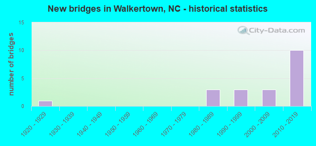
- New bridges - historical statistics
- 11920-1929
- 31980-1989
- 31990-1999
- 32000-2009
- 102010-2019


- Bridge Condition - Deck
- 20.0%Very good
- 80.0%Good

- Bridge Condition - Superstructure
- 20.0%Excellent
- 40.0%Very good
- 20.0%Good
- 20.0%Satisfactory

- Bridge Condition - Substructure
- 20.0%Very good
- 60.0%Good
- 20.0%Satisfactory

- Bridge Condition - Channel
- 70.0%Good
- 30.0%Satisfactory

- Bridge Condition - Culverts
- 25.0%Good
- 62.5%Satisfactory
- 12.5%Fair
Find on map >> Show street view
Structure Number: 670041, Location: 0.3 MI. S. JCT. NC66 (Lat: 36.175181, Lng: -80.195664), Route carried "on" structure: State highway 2219, Year Built: 2003, Status: Open, Structure Length: 1.52m (4.99ft), Average Daily Traffic: 1,200 (year 2019), Truck Traffic: 7%, Average Future Daily Traffic: 2,400 (year 2040), Design Load: HS 20+Mod, Features Intersected: MILL CREEK
Minimum Vertical Clearance: 30+ m (98+ ft), Kilometerpoint: 0.000, Lanes on structure: 2, Owner: State Highway Agency, Approaching Roadway Width: 7.3m (24.0ft), Skew: 2 degrees, Material/Design: Steel, Design/Construction: Culvert, Number Of Spans In Main Unit: 3, Length of Maximum Span: 3.0m (9.8ft)
Condition: Channel: Good, Culverts: Satisfactory, Operating Rating: 89.8 metric tons, Method Used To Determine Operating Rating: Load and Resistance Factor (LRFR), Inventory Rating: 89.8 metric tons, Method Used To Determine Inventory Rating: Load and Resistance Factor (LRFR), Structural Evaluation: Equal to present minimum criteria, Waterway Adequacy: Better than present minimum criteria, Approach Roadway Alignment: Equal to present desirable criteria, Designated Inspection Frequency: Every 24 months, Inspection Date: August 2021
Find on map >> Show street view
Structure Number: 670042, Location: 0.7 MI. S. JCT. NC66 (Lat: 36.175019, Lng: -80.205044), Route carried "on" structure: State highway 2216, Year Built: 1987, Status: Open, Structure Length: 1.21m (3.97ft), Average Daily Traffic: 1,100 (year 2019), Truck Traffic: 7%, Average Future Daily Traffic: 2,200 (year 2040), Design Load: HS 20+Mod, Features Intersected: MILL CREEK
Minimum Vertical Clearance: 30+ m (98+ ft), Kilometerpoint: 0.000, Lanes on structure: 2, Owner: State Highway Agency, Approaching Roadway Width: 6.0m (19.7ft), Material/Design: Steel, Design/Construction: Culvert, Number Of Spans In Main Unit: 3, Length of Maximum Span: 3.6m (11.8ft)
Condition: Channel: Satisfactory, Culverts: Satisfactory, Operating Rating: 89.8 metric tons, Method Used To Determine Operating Rating: Load and Resistance Factor (LRFR), Inventory Rating: 82.5 metric tons, Method Used To Determine Inventory Rating: Load and Resistance Factor (LRFR), Structural Evaluation: Equal to present minimum criteria, Waterway Adequacy: Equal to present minimum criteria, Approach Roadway Alignment: Equal to present desirable criteria, Designated Inspection Frequency: Every 24 months, Inspection Date: August 2021
Find on map >> Show street view
Structure Number: 670057, Location: 0.3 MI. S. JCT. SR1922 (Lat: 36.203658, Lng: -80.122064), Route carried "on" structure: State highway 2008, Year Built: 2005, Status: Open, Structure Length: 1.88m (6.17ft), Average Daily Traffic: 930 (year 2015), Truck Traffic: 6%, Average Future Daily Traffic: 1,860 (year 2040), Design Load: HS 20+Mod, Features Intersected: WEST BELEWS CREEK
Minimum Vertical Clearance: 30+ m (98+ ft), Kilometerpoint: 0.000, Lanes on structure: 2, Owner: State Highway Agency, Approaching Roadway Width: 6.7m (22.0ft), Material/Design: Prestressed concrete, Design/Construction: Slab, Number Of Spans In Main Unit: 1, Length of Maximum Span: 17.9m (58.7ft), Curb-To-Curb Width: 7.2m (23.6ft), Out-to-Out Width: 8.2m (26.9ft)
Condition: Deck: Good, Superstructure: Good, Substructure: Good, Channel: Good, Operating Rating: 68.0 metric tons, Method Used To Determine Operating Rating: Load Factor (LF), Inventory Rating: 40.8 metric tons, Method Used To Determine Inventory Rating: Load Factor (LF), Structural Evaluation: Better than present minimum criteria, Deck Geometry: Meets minimum limits, Waterway Adequacy: Equal to present desirable criteria, Approach Roadway Alignment: Equal to present minimum criteria, Designated Inspection Frequency: Every 24 months, Inspection Date: August 2021, Deck Structure Type: Concrete Precast Panels, Wearing Surface/Protective System: Wearing Surface: Bituminous
Find on map >> Show street view
Structure Number: 670064, Location: 0.9 MI. E. JCT. US311 (Lat: 36.222800, Lng: -80.154667), Route carried "on" structure: State highway 1979, Year Built: 1993, Status: Open, Structure Length: 1.70m (5.58ft), Average Daily Traffic: 400 (year 2019), Truck Traffic: 7%, Average Future Daily Traffic: 800 (year 2040), Design Load: HL 93, Features Intersected: LICK CREEK
Minimum Vertical Clearance: 30+ m (98+ ft), Kilometerpoint: 0.000, Lanes on structure: 2, Owner: State Highway Agency, Approaching Roadway Width: 6.4m (21.0ft), Material/Design: Steel, Design/Construction: Culvert, Number Of Spans In Main Unit: 4, Length of Maximum Span: 3.3m (10.8ft)
Condition: Channel: Satisfactory, Culverts: Satisfactory, Operating Rating: 89.8 metric tons, Method Used To Determine Operating Rating: Load and Resistance Factor (LRFR), Inventory Rating: 89.8 metric tons, Method Used To Determine Inventory Rating: Load and Resistance Factor (LRFR), Structural Evaluation: Equal to present minimum criteria, Waterway Adequacy: Better than present minimum criteria, Approach Roadway Alignment: Equal to present desirable criteria, Designated Inspection Frequency: Every 24 months, Inspection Date: August 2021
Find on map >> Show street view
Structure Number: 670065, Location: 0.6 MI. N. JCT. SR2377 (Lat: 36.126636, Lng: -80.159256), Route carried "on" structure: State highway 2385, Year Built: 1980, Status: Open, Structure Length: 1.24m (4.07ft), Average Daily Traffic: 4,100 (year 2019), Truck Traffic: 7%, Average Future Daily Traffic: 8,200 (year 2040), Design Load: HS 20+Mod, Features Intersected: MARTIN MILL CREEK
Minimum Vertical Clearance: 30+ m (98+ ft), Kilometerpoint: 0.000, Lanes on structure: 2, Owner: State Highway Agency, Approaching Roadway Width: 7.6m (24.9ft), Material/Design: Steel, Design/Construction: Culvert, Number Of Spans In Main Unit: 2, Length of Maximum Span: 5.4m (17.7ft)
Condition: Channel: Good, Culverts: Satisfactory, Operating Rating: 85.2 metric tons, Method Used To Determine Operating Rating: Load and Resistance Factor (LRFR), Inventory Rating: 66.2 metric tons, Method Used To Determine Inventory Rating: Load and Resistance Factor (LRFR), Structural Evaluation: Equal to present minimum criteria, Waterway Adequacy: Better than present minimum criteria, Approach Roadway Alignment: Equal to present desirable criteria, Designated Inspection Frequency: Every 24 months, Inspection Date: August 2021
Find on map >> Show street view
Structure Number: 670067, Location: 0.6 MI. W. JCT. SR2021 (Lat: 36.176961, Lng: -80.099969), Route carried "on" structure: State highway 2014, Year Built: 1998, Status: Open, Structure Length: 1.31m (4.30ft), Average Daily Traffic: 3,600 (year 2019), Truck Traffic: 7%, Average Future Daily Traffic: 7,200 (year 2040), Design Load: HS 20+Mod, Features Intersected: BELEWS CREEK
Minimum Vertical Clearance: 30+ m (98+ ft), Kilometerpoint: 0.000, Lanes on structure: 2, Owner: State Highway Agency, Approaching Roadway Width: 7.0m (23.0ft), Skew: 3 degrees, Material/Design: Concrete continuous, Design/Construction: Culvert, Number Of Spans In Main Unit: 4, Length of Maximum Span: 2.7m (8.9ft)
Condition: Channel: Good, Culverts: Good, Operating Rating: 65.3 metric tons, Method Used To Determine Operating Rating: Load and Resistance Factor (LRFR), Inventory Rating: 49.8 metric tons, Method Used To Determine Inventory Rating: Load and Resistance Factor (LRFR), Structural Evaluation: Better than present minimum criteria, Waterway Adequacy: Better than present minimum criteria, Approach Roadway Alignment: Equal to present desirable criteria, Designated Inspection Frequency: Every 24 months, Inspection Date: September 2021
Find on map >> Show street view
Structure Number: 67014, Location: 0.1 MI. E. JCT. SR2396 (Lat: 36.141511, Lng: -80.160878), Route carried "on" structure: US 158, Year Built: 1928, Year Reconstructed: 1955, Status: Open, Structure Length: 0.79m (2.59ft), Average Daily Traffic: 15,000 (year 2019), Truck Traffic: 12%, Average Future Daily Traffic: 30,000 (year 2040), Design Load: HS 20+Mod, Features Intersected: LOWERY MILL CREEK
Minimum Vertical Clearance: 30+ m (98+ ft), Kilometerpoint: 0.000, Lanes on structure: 2, Base Highway Network: Yes (Inventory Route: 2, Subroute: 58), Owner: State Highway Agency, Approaching Roadway Width: 8.8m (28.9ft), Skew: 3 degrees, Material/Design: Concrete continuous, Design/Construction: Culvert, Number Of Spans In Main Unit: 3, Length of Maximum Span: 2.1m (6.9ft)
Condition: Channel: Satisfactory, Culverts: Fair, Operating Rating: 41.7 metric tons, Method Used To Determine Operating Rating: Field evaluation and documented engineering judgment, Inventory Rating: 32.6 metric tons, Method Used To Determine Inventory Rating: Field evaluation and documented engineering judgment, Structural Evaluation: Somewhat better than minimum adequacy, Waterway Adequacy: Better than present minimum criteria, Approach Roadway Alignment: Equal to present desirable criteria, Designated Inspection Frequency: Every 24 months, Inspection Date: August 2021
Find on map >> Show street view
Structure Number: 67017, Location: 0.3 MI. N. JCT. US158 (Lat: 36.196811, Lng: -80.100172), Route carried "on" structure: State highway 1975, Year Built: 1991, Status: Open, Structure Length: 0.73m (2.40ft), Average Daily Traffic: 850 (year 2019), Truck Traffic: 7%, Average Future Daily Traffic: 1,700 (year 2040), Design Load: HS 20+Mod, Features Intersected: UT TO BELEWS CREEK
Minimum Vertical Clearance: 30+ m (98+ ft), Kilometerpoint: 0.000, Lanes on structure: 2, Owner: State Highway Agency, Approaching Roadway Width: 6.0m (19.7ft), Material/Design: Steel, Design/Construction: Culvert, Number Of Spans In Main Unit: 2, Length of Maximum Span: 3.3m (10.8ft)
Condition: Channel: Good, Culverts: Satisfactory, Operating Rating: 89.8 metric tons, Method Used To Determine Operating Rating: Load and Resistance Factor (LRFR), Inventory Rating: 89.8 metric tons, Method Used To Determine Inventory Rating: Load and Resistance Factor (LRFR), Structural Evaluation: Equal to present minimum criteria, Waterway Adequacy: Better than present minimum criteria, Approach Roadway Alignment: Equal to present desirable criteria, Designated Inspection Frequency: Every 24 months, Inspection Date: August 2021
Find on map >> Show street view
Structure Number: 670176, Location: 0.4 MI. W. JCT. US158 (Lat: 36.193711, Lng: -80.107558), Route carried "on" structure: State highway 2009, Year Built: 2000, Status: Open, Structure Length: 0.82m (2.69ft), Average Daily Traffic: 50 (year 1999), Average Future Daily Traffic: 100 (year 2040), Design Load: HS 20+Mod, Features Intersected: UT TO BELEWS CREEK
Minimum Vertical Clearance: 30+ m (98+ ft), Kilometerpoint: 0.000, Lanes on structure: 2, Owner: State Highway Agency, Approaching Roadway Width: 5.7m (18.7ft), Material/Design: Steel, Design/Construction: Culvert, Number Of Spans In Main Unit: 2, Length of Maximum Span: 3.6m (11.8ft)
Condition: Channel: Good, Culverts: Good, Operating Rating: 89.8 metric tons, Method Used To Determine Operating Rating: Load and Resistance Factor (LRFR), Inventory Rating: 89.8 metric tons, Method Used To Determine Inventory Rating: Load and Resistance Factor (LRFR), Structural Evaluation: Better than present minimum criteria, Waterway Adequacy: Better than present minimum criteria, Approach Roadway Alignment: Equal to present minimum criteria, Designated Inspection Frequency: Every 24 months, Inspection Date: August 2021
Find on map >> Show street view
Structure Number: 670192, Location: 0.8 MI.N.JCT.SR1965 (Lat: 36.214633, Lng: -80.113300), Route carried "on" structure: State highway 1975, Year Built: 1982, Status: Open, Structure Length: 3.29m (10.79ft), Average Daily Traffic: 1,600 (year 2016), Truck Traffic: 7%, Average Future Daily Traffic: 3,000 (year 2040), Design Load: HS 20+Mod, Features Intersected: WEST BELEWS CREEK
Minimum Vertical Clearance: 30+ m (98+ ft), Kilometerpoint: 0.000, Lanes on structure: 2, Owner: State Highway Agency, Approaching Roadway Width: 5.7m (18.7ft), Skew: 4 degrees, Material/Design: Prestressed concrete, Design/Construction: Slab, Number Of Spans In Main Unit: 3, Length of Maximum Span: 10.3m (33.8ft), Curb-To-Curb Width: 7.5m (24.6ft), Out-to-Out Width: 8.3m (27.2ft)
Condition: Deck: Good, Superstructure: Satisfactory, Substructure: Satisfactory, Channel: Good, Operating Rating: 89.8 metric tons, Method Used To Determine Operating Rating: Load Factor (LF), Inventory Rating: 58.0 metric tons, Method Used To Determine Inventory Rating: Load Factor (LF), Structural Evaluation: Equal to present minimum criteria, Deck Geometry: Meets minimum limits, Waterway Adequacy: Equal to present minimum criteria, Approach Roadway Alignment: Equal to present desirable criteria, Designated Inspection Frequency: Every 24 months, Inspection Date: August 2021, Deck Structure Type: Concrete Precast Panels, Wearing Surface/Protective System: Wearing Surface: Bituminous
Find on map >> Show street view
Structure Number: 670666, Location: 1.75 MI W OF NC66 (Lat: 36.145983, Lng: -80.162650), Route carried "on" structure: State highway 158, Year Built: 2018, Status: Open, Structure Length: 7.13m (23.39ft), Average Daily Traffic: 16,000 (year 2016), Truck Traffic: 12%, Average Future Daily Traffic: 32,000 (year 2040), Design Load: HL 93, Features Intersected: FUTURE I-74
Minimum Vertical Clearance: 30+ m (98+ ft), Kilometerpoint: 0.000, Lanes on structure: 2, Lanes under structure: 10, Base Highway Network: Yes (Inventory Route: 3, Subroute: 58), Owner: State Highway Agency, Approaching Roadway Width: 8.5m (27.9ft), Material/Design: Prestressed concrete, Design/Construction: Stringer/Multi-beam, Number Of Spans In Main Unit: 2, Number Of Approach Spans: 1, Length of Maximum Span: 35.0m (114.8ft), Curb-To-Curb Width: 31.5m (103.3ft), Out-to-Out Width: 32.6m (107.0ft)
Condition: Deck: Very good, Superstructure: Very good, Substructure: Very good, Operating Rating: 76.2 metric tons, Method Used To Determine Operating Rating: Load and Resistance Factor (LRFR), Inventory Rating: 47.1 metric tons, Method Used To Determine Inventory Rating: Load and Resistance Factor (LRFR), Structural Evaluation: Equal to present desirable criteria, Deck Geometry: Superior to present desirable criteria, Underclear: Equal to present minimum criteria, Approach Roadway Alignment: Equal to present desirable criteria, Designated Inspection Frequency: Every 24 months, Inspection Date: June 2020, Deck Structure Type: Concrete Cast-file-Place, Wearing Surface/Protective System: Wearing Surface: Monolithic Concrete
Find on map >> Show street view
Structure Number: 670667, Location: 0.8M. S. JCT. SR2407 (Lat: 36.140667, Lng: -80.147194), Route carried "on" structure: State highway 2385, Year Built: 2016, Status: Open, Structure Length: 6.98m (22.90ft), Average Daily Traffic: 3,300 (year 2017), Truck Traffic: 7%, Average Future Daily Traffic: 6,600 (year 2040), Design Load: HL 93, Features Intersected: I-74
Minimum Vertical Clearance: 30+ m (98+ ft), Kilometerpoint: 0.000, Lanes on structure: 2, Lanes under structure: 6, Owner: State Highway Agency, Approaching Roadway Width: 10.3m (33.8ft), Skew: 1 degrees, Material/Design: Prestressed concrete, Design/Construction: Stringer/Multi-beam, Number Of Spans In Main Unit: 2, Length of Maximum Span: 34.7m (113.8ft), Curb-To-Curb Width: 10.4m (34.1ft), Out-to-Out Width: 11.6m (38.1ft)
Condition: Deck: Good, Superstructure: Very good, Substructure: Good, Operating Rating: 84.3 metric tons, Method Used To Determine Operating Rating: Load and Resistance Factor (LRFR), Inventory Rating: 50.8 metric tons, Method Used To Determine Inventory Rating: Load and Resistance Factor (LRFR), Structural Evaluation: Better than present minimum criteria, Deck Geometry: Somewhat better than minimum adequacy, Underclear: High priority of corrective action, Approach Roadway Alignment: Equal to present desirable criteria, Designated Inspection Frequency: Every 24 months, Inspection Date: March 2020, Deck Structure Type: Concrete Cast-file-Place, Wearing Surface/Protective System: Wearing Surface: Monolithic Concrete
Find on map >> Show street view
Structure Number: 6707, Location: 0.42 MI. S. SR2391 (Lat: 36.151950, Lng: -80.179822), Route carried "on" structure: US 311, Year Built: 2019, Status: Open, Structure Length: 6.73m (22.08ft), Average Daily Traffic: 3,500 (year 2019), Truck Traffic: 6%, Average Future Daily Traffic: 7,000 (year 2040), Design Load: HL 93, Features Intersected: I-74
Minimum Vertical Clearance: 30+ m (98+ ft), Kilometerpoint: 0.000, Lanes on structure: 2, Lanes under structure: 3, Owner: State Highway Agency, Approaching Roadway Width: 17.6m (57.7ft), Skew: 20 degrees, Material/Design: Prestressed concrete, Design/Construction: Stringer/Multi-beam, Number Of Spans In Main Unit: 2, Length of Maximum Span: 33.2m (108.9ft), Curb-To-Curb Width: 17.3m (56.8ft), Out-to-Out Width: 18.5m (60.7ft)
Condition: Deck: Good, Superstructure: Excellent, Substructure: Good, Operating Rating: 68.9 metric tons, Method Used To Determine Operating Rating: Load and Resistance Factor (LRFR), Inventory Rating: 46.2 metric tons, Method Used To Determine Inventory Rating: Load and Resistance Factor (LRFR), Structural Evaluation: Better than present minimum criteria, Deck Geometry: Superior to present desirable criteria, Underclear: High priority of corrective action, Approach Roadway Alignment: Equal to present desirable criteria, Designated Inspection Frequency: Every 24 months, Inspection Date: September 2021, Deck Structure Type: Concrete Cast-file-Place, Wearing Surface/Protective System: Wearing Surface: Monolithic Concrete
Find on map >> Show street view
Structure Number: 670666, Location: 1.75 MI W OF NC66 (Lat: 36.145983, Lng: -80.162650), Route carried "under" structure: Interstate 74, Year Built: 2018, Structure Length: 0. m, Average Daily Traffic: 26,250 (year 2018), Truck Traffic: 12%, Features Intersected: NC158
Minimum Vertical Clearance: 5.53m (18.14ft), Kilometerpoint: 0.000, Lanes on structure: 2, Lanes under structure: 3, Material/Design: Prestressed concrete, Design/Construction: Stringer/Multi-beam, Length of Maximum Span: 35.0m (114.8ft)
Find on map >> Show street view
Structure Number: 670666, Location: 1.75 MI W OF NC66 (Lat: 36.145983, Lng: -80.162650), Route carried "under" structure: Interstate 80000, Year Built: 2018, Structure Length: 0. m, Average Daily Traffic: 26,250 (year 2018), Truck Traffic: 12%, Features Intersected: NC158, Facility Carried by Structure: I 74 N
Minimum Vertical Clearance: 5.97m (19.59ft), Kilometerpoint: 0.000, Lanes on structure: 2, Lanes under structure: 3, Material/Design: Prestressed concrete, Design/Construction: Stringer/Multi-beam, Length of Maximum Span: 35.0m (114.8ft)
Find on map >> Show street view
Structure Number: 670666, Location: 1.75 MI W OF NC66 (Lat: 36.145983, Lng: -80.162650), Route carried "under" structure: Interstate 74, Year Built: 2018, Structure Length: 0. m, Average Daily Traffic: 26,250 (year 2018), Truck Traffic: 16%, Features Intersected: NC158
Minimum Vertical Clearance: 5.63m (18.47ft), Kilometerpoint: 0.000, Lanes on structure: 2, Lanes under structure: 4, Material/Design: Prestressed concrete, Design/Construction: Stringer/Multi-beam, Length of Maximum Span: 35.0m (114.8ft)
Find on map >> Show street view
Structure Number: 670667, Location: 0.8M. S. JCT. SR2407 (Lat: 36.140667, Lng: -80.147194), Route carried "under" structure: Interstate 74, Year Built: 2016, Structure Length: 0. m, Average Daily Traffic: 100 (year 2018), Truck Traffic: 16%, Features Intersected: SR 2385 (Walkertown Guth
Minimum Vertical Clearance: 5.91m (19.39ft), Kilometerpoint: 0.000, Lanes on structure: 2, Lanes under structure: 3, Material/Design: Prestressed concrete, Design/Construction: Stringer/Multi-beam, Length of Maximum Span: 34.7m (113.8ft)
Find on map >> Show street view
Structure Number: 670667, Location: 0.8M. S. JCT. SR2407 (Lat: 36.140667, Lng: -80.147194), Route carried "under" structure: Interstate 74, Year Built: 2016, Structure Length: 0. m, Average Daily Traffic: 100 (year 2018), Truck Traffic: 16%, Features Intersected: SR 2385 (Walkertown Guth
Minimum Vertical Clearance: 5.86m (19.23ft), Kilometerpoint: 0.000, Lanes on structure: 2, Lanes under structure: 3, Material/Design: Prestressed concrete, Design/Construction: Stringer/Multi-beam, Length of Maximum Span: 34.7m (113.8ft)
Find on map >> Show street view
Structure Number: 6707, Location: 0.42 MI. S. SR2391 (Lat: 36.151950, Lng: -80.179822), Route carried "under" structure: Interstate 74, Year Built: 2019, Structure Length: 0. m, Average Daily Traffic: 21,250 (year 2019), Truck Traffic: 12%, Features Intersected: US311
Minimum Vertical Clearance: 6.08m (19.95ft), Kilometerpoint: 0.000, Lanes on structure: 2, Lanes under structure: 2, Material/Design: Prestressed concrete, Design/Construction: Stringer/Multi-beam, Length of Maximum Span: 33.2m (108.9ft)
Find on map >> Show street view
Structure Number: 6707, Location: 0.42 MI. S. SR2391 (Lat: 36.151950, Lng: -80.179822), Route carried "under" structure: Interstate 74, Year Built: 2019, Structure Length: 0. m, Average Daily Traffic: 21,250 (year 2019), Truck Traffic: 12%, Features Intersected: US311
Minimum Vertical Clearance: 5.85m (19.19ft), Kilometerpoint: 0.000, Lanes on structure: 2, Lanes under structure: 1, Material/Design: Prestressed concrete, Design/Construction: Stringer/Multi-beam, Length of Maximum Span: 33.2m (108.9ft)