Bridge Statistics for Walsenburg, Colorado (CO)
Condition, Traffic, Stress, Structural Evaluation, Project Costs
- National Bridge Inventory (NBI) Statistics
- 30Number of bridges
- 466ft / 142mTotal length
- $20,761,000Total costs
- 127,468Total average daily traffic
- 20,675Total average daily truck traffic
- National Bridge Inventory (NBI) Registered Bridges for Walsenburg
- No street view available for this location
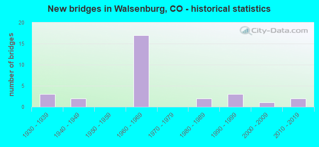
- New bridges - historical statistics
- 31930-1939
- 21940-1949
- 171960-1969
- 21980-1989
- 31990-1999
- 12000-2009
- 22010-2019


- Bridge Condition - Deck
- 8.3%Very good
- 8.3%Good
- 50.0%Satisfactory
- 33.3%Fair

- Bridge Condition - Superstructure
- 4.2%Very good
- 54.2%Good
- 16.7%Satisfactory
- 25.0%Fair

- Bridge Condition - Substructure
- 4.2%Very good
- 37.5%Good
- 33.3%Satisfactory
- 16.7%Fair
- 8.3%Poor

- Bridge Condition - Channel
- 61.9%Very good
- 23.8%Good
- 9.5%Satisfactory
- 4.8%Fair

- Bridge Condition - Culverts
- 50.0%Good
- 50.0%Satisfactory
Find on map >> Show street view
Structure Number: HU302-SO1-S160A, Location: 0.1 MI SOUTH OF US160 (Lat: 37.616558, Lng: -104.796178), Route carried "on" structure: County highway , Year Built: 1989, Status: Open, Structure Length: 6.16m (20.21ft), Average Daily Traffic: 101 (year 2018), Truck Traffic: 2%, Average Future Daily Traffic: 145 (year 2038), Features Intersected: CUCHARAS RIVER, Facility Carried by Structure: CR 340/BEAR CRK
Minimum Vertical Clearance: 30+ m (98+ ft), Kilometerpoint: 24.996, Lanes on structure: 2, Owner: County Highway Agency, Approaching Roadway Width: 8.2m (26.9ft), Material/Design: Steel continuous, Design/Construction: Stringer/Multi-beam, Number Of Spans In Main Unit: 3, Length of Maximum Span: 23.3m (76.4ft), Curb-To-Curb Width: 9.6m (31.5ft), Out-to-Out Width: 9.8m (32.2ft)
Condition: Deck: Satisfactory, Superstructure: Satisfactory, Substructure: Satisfactory, Channel: Satisfactory, Operating Rating: 48.5 metric tons, Method Used To Determine Operating Rating: Load Factor (LF), Inventory Rating: 29.0 metric tons, Method Used To Determine Inventory Rating: Load Factor (LF), Structural Evaluation: Equal to present minimum criteria, Deck Geometry: Equal to present minimum criteria, Waterway Adequacy: Equal to present desirable criteria, Approach Roadway Alignment: Equal to present desirable criteria, Designated Inspection Frequency: Every 24 months, Inspection Date: January 2021, Deck Structure Type: Corrugated Steel, Wearing Surface/Protective System: Wearing Surface: Bituminous
Find on map >> Show street view
Structure Number: HU330-SO3-S160A, Location: 0.1 MI S OF I-25 Business (Lat: 37.613939, Lng: -104.773892), Route carried "on" structure: County highway , Year Built: 1991, Status: Open, Structure Length: 2.49m (8.17ft), Average Daily Traffic: 150 (year 2018), Truck Traffic: 2%, Average Future Daily Traffic: 216 (year 2038), Design Load: HS 20, Features Intersected: BEAR CREEK, Facility Carried by Structure: COUNTY ROAD 330
Minimum Vertical Clearance: 30+ m (98+ ft), Kilometerpoint: 16.767, Lanes on structure: 2, Owner: County Highway Agency, Approaching Roadway Width: 7.0m (23.0ft), Skew: 1 degrees, Material/Design: Steel, Design/Construction: Stringer/Multi-beam, Number Of Spans In Main Unit: 1, Length of Maximum Span: 23.1m (75.8ft), Curb-To-Curb Width: 9.7m (31.8ft), Out-to-Out Width: 9.8m (32.2ft)
Condition: Deck: Fair, Superstructure: Good, Substructure: Good, Channel: Good, Operating Rating: 48.5 metric tons, Method Used To Determine Operating Rating: Load Factor (LF), Inventory Rating: 29.0 metric tons, Method Used To Determine Inventory Rating: Load Factor (LF), Structural Evaluation: Better than present minimum criteria, Deck Geometry: Equal to present minimum criteria, Waterway Adequacy: Equal to present desirable criteria, Approach Roadway Alignment: Better than present minimum criteria, Designated Inspection Frequency: Every 24 months, Inspection Date: January 2021, Deck Structure Type: Corrugated Steel, Wearing Surface/Protective System: Wearing Surface: Gravel
Find on map >> Show street view
Structure Number: HU598-S0.4-S69A, Location: .5 MI SOUTH OF SH 69 (Lat: 37.642267, Lng: -104.817939), Route carried "on" structure: County highway , Year Built: 1989, Status: Open, Structure Length: 3.40m (11.15ft), Average Daily Traffic: 160 (year 2018), Truck Traffic: 2%, Average Future Daily Traffic: 230 (year 2038), Features Intersected: PICTOU ARROYO, Facility Carried by Structure: COUNTY ROAD 598
Minimum Vertical Clearance: 30+ m (98+ ft), Kilometerpoint: 2.475, Lanes on structure: 2, Owner: County Highway Agency, Approaching Roadway Width: 6.4m (21.0ft), Skew: 2 degrees, Material/Design: Steel continuous, Design/Construction: Stringer/Multi-beam, Number Of Spans In Main Unit: 2, Length of Maximum Span: 16.0m (52.5ft), Curb-To-Curb Width: 9.4m (30.8ft), Out-to-Out Width: 9.8m (32.2ft)
Condition: Deck: Satisfactory, Superstructure: Good, Substructure: Satisfactory, Channel: Fair, Operating Rating: 52.3 metric tons, Method Used To Determine Operating Rating: Load Factor (LF), Inventory Rating: 31.3 metric tons, Method Used To Determine Inventory Rating: Load Factor (LF), Structural Evaluation: Equal to present minimum criteria, Deck Geometry: Equal to present minimum criteria, Waterway Adequacy: Equal to present desirable criteria, Approach Roadway Alignment: Better than present minimum criteria, Designated Inspection Frequency: Every 24 months, Inspection Date: January 2021, Deck Structure Type: Corrugated Steel, Wearing Surface/Protective System: Wearing Surface: Bituminous
Find on map >> Show street view
Structure Number: N-17-A, Location: 3.9 MI NW OF JCT I 25 (Lat: 37.675900, Lng: -104.844000), Route carried "on" structure: State highway 69A, Year Built: 1940, Status: Open, Structure Length: 4.93m (16.17ft), Average Daily Traffic: 890 (year 2020), Truck Traffic: 8%, Average Future Daily Traffic: 1,210 (year 2040), Design Load: H 15, Features Intersected: MISSOURI CREEK, Facility Carried by Structure: SH 69 ML
Minimum Vertical Clearance: 30+ m (98+ ft), Kilometerpoint: 6.181, Lanes on structure: 2, Base Highway Network: Yes, Owner: State Highway Agency, Approaching Roadway Width: 7.3m (24.0ft), Skew: 3 degrees, Material/Design: Steel, Design/Construction: Stringer/Multi-beam, Number Of Spans In Main Unit: 4, Length of Maximum Span: 11.7m (38.4ft), Curb-To-Curb Width: 7.6m (24.9ft), Out-to-Out Width: 7.9m (25.9ft)
Condition: Deck: Satisfactory, Superstructure: Satisfactory, Substructure: Satisfactory, Channel: Very good, Operating Rating: 45.4 metric tons, Method Used To Determine Operating Rating: Load Factor (LF), Inventory Rating: 27.2 metric tons, Method Used To Determine Inventory Rating: Load Factor (LF), Structural Evaluation: Equal to present minimum criteria, Deck Geometry: Meets minimum limits, Waterway Adequacy: Equal to present desirable criteria, Approach Roadway Alignment: Equal to present desirable criteria, Designated Inspection Frequency: Every 24 months, Inspection Date: Febuary 2021, Deck Structure Type: Wood or Timber, Wearing Surface/Protective System: Wearing Surface: Bituminous
Find on map >> Show street view
Structure Number: N-17-AC, Location: 1.1 MI N WALSENBURG BUS R (Lat: 37.631567, Lng: -104.768033), Route carried "on" structure: Interstate 25A, Year Built: 1963, Status: Open, Structure Length: 12.88m (42.26ft), Average Daily Traffic: 5,000 (year 2020), Truck Traffic: 19%, Average Future Daily Traffic: 6,650 (year 2040), Design Load: HS 20, Features Intersected: US 160,SH 10, RR SPUR, Facility Carried by Structure: I 25 ML NBND
Minimum Vertical Clearance: 30+ m (98+ ft), Kilometerpoint: 80.556, Lanes on structure: 2, Lanes under structure: 2, Base Highway Network: Yes, Owner: State Highway Agency, Approaching Roadway Width: 13.1m (43.0ft), Skew: 10 degrees, Material/Design: Steel continuous, Design/Construction: Stringer/Multi-beam, Number Of Spans In Main Unit: 7, Length of Maximum Span: 20.4m (66.9ft), Curb-To-Curb Width: 9.1m (29.9ft), Out-to-Out Width: 10.4m (34.1ft)
Condition: Deck: Fair, Superstructure: Fair, Substructure: Poor, Operating Rating: 38.6 metric tons, Method Used To Determine Operating Rating: Load Factor (LF), Inventory Rating: 23.1 metric tons, Method Used To Determine Inventory Rating: Load Factor (LF), Structural Evaluation: Meets minimum limits, Deck Geometry: Meets minimum limits, Underclear: Meets minimum limits, Approach Roadway Alignment: Equal to present desirable criteria, Designated Inspection Frequency: Every 24 months, Inspection Date: January 2022, Deck Structure Type: Concrete Cast-file-Place, Wearing Surface/Protective System: Wearing Surface: Bituminous, Membrane: Built-up
Find on map >> Show street view
Structure Number: N-17-AD, Location: 1.15 MI N WALSENBURG BUS (Lat: 37.631433, Lng: -104.768275), Route carried "on" structure: Interstate 25A, Year Built: 1963, Status: Open, Structure Length: 12.90m (42.32ft), Average Daily Traffic: 5,000 (year 2020), Truck Traffic: 19%, Average Future Daily Traffic: 6,650 (year 2040), Design Load: HS 20+Mod, Features Intersected: US 160, SH 10, RR SPUR, Facility Carried by Structure: I 25 ML SBND
Minimum Vertical Clearance: 30+ m (98+ ft), Kilometerpoint: 80.552, Lanes on structure: 2, Lanes under structure: 2, Base Highway Network: Yes, Owner: State Highway Agency, Approaching Roadway Width: 11.6m (38.1ft), Skew: 10 degrees, Material/Design: Steel continuous, Design/Construction: Stringer/Multi-beam, Number Of Spans In Main Unit: 7, Length of Maximum Span: 19.9m (65.3ft), Curb-To-Curb Width: 9.1m (29.9ft), Out-to-Out Width: 10.4m (34.1ft)
Condition: Deck: Fair, Superstructure: Fair, Substructure: Poor, Operating Rating: 42.2 metric tons, Method Used To Determine Operating Rating: Load Factor (LF), Inventory Rating: 25.2 metric tons, Method Used To Determine Inventory Rating: Load Factor (LF), Structural Evaluation: Meets minimum limits, Deck Geometry: Meets minimum limits, Underclear: Equal to present minimum criteria, Approach Roadway Alignment: Equal to present desirable criteria, Length Of Structure Improvement: 12.90m (42.32ft), Designated Inspection Frequency: Every 24 months, Inspection Date: July 2020, Bridge Improvement Cost: $4,896,000, Roadway Improvement Cost: $490,000, Total Project Cost: $7,343,000 ( Estimate for 2016), Deck Structure Type: Concrete Cast-file-Place, Wearing Surface/Protective System: Wearing Surface: Bituminous, Membrane: Built-up
Find on map >> Show street view
Structure Number: N-17-AE, Location: SO CONNECT OF WALSENBURG (Lat: 37.617647, Lng: -104.759839), Route carried "on" structure: Business State highway 25C, Year Built: 1963, Status: Open, Structure Length: 8.18m (26.84ft), Average Daily Traffic: 1,200 (year 2020), Truck Traffic: 10%, Average Future Daily Traffic: 1,212 (year 2040), Design Load: HS 20, Features Intersected: I 25 ML, Facility Carried by Structure: I 25 BUS RT
Minimum Vertical Clearance: 30+ m (98+ ft), Kilometerpoint: 0.130, Lanes on structure: 2, Lanes under structure: 4, Owner: State Highway Agency, Approaching Roadway Width: 8.5m (27.9ft), Skew: 3 degrees, Material/Design: Concrete continuous, Design/Construction: Tee Beam, Number Of Spans In Main Unit: 4, Length of Maximum Span: 23.2m (76.1ft), Curb-To-Curb Width: 8.5m (27.9ft), Out-to-Out Width: 9.8m (32.2ft)
Condition: Deck: Satisfactory, Superstructure: Good, Substructure: Good, Operating Rating: 58.4 metric tons, Method Used To Determine Operating Rating: Load Factor (LF), Inventory Rating: 35.0 metric tons, Method Used To Determine Inventory Rating: Load Factor (LF), Structural Evaluation: Better than present minimum criteria, Deck Geometry: Somewhat better than minimum adequacy, Underclear: High priority of corrective action, Approach Roadway Alignment: Equal to present desirable criteria, Designated Inspection Frequency: Every 24 months, Inspection Date: January 2021, Deck Structure Type: Concrete Cast-file-Place, Wearing Surface/Protective System: Wearing Surface: Bituminous
Find on map >> Show street view
Structure Number: N-17-B, Location: 3.2 MI N OF SH10-WLSNBRG. (Lat: 37.683883, Lng: -104.806631), Route carried "on" structure: Interstate 25A, Year Built: 1967, Status: Open, Structure Length: 2.50m (8.20ft), Average Daily Traffic: 6,500 (year 2020), Truck Traffic: 16%, Average Future Daily Traffic: 8,255 (year 2040), Design Load: HS 20+Mod, Features Intersected: MISSOURI CREEK, Facility Carried by Structure: I 25 ML SBND
Minimum Vertical Clearance: 30+ m (98+ ft), Kilometerpoint: 87.394, Lanes on structure: 2, Base Highway Network: Yes, Owner: State Highway Agency, Approaching Roadway Width: 11.6m (38.1ft), Skew: 12 degrees, Material/Design: Concrete continuous, Design/Construction: Tee Beam, Number Of Spans In Main Unit: 3, Length of Maximum Span: 10.0m (32.8ft), Curb-To-Curb Width: 11.9m (39.0ft), Out-to-Out Width: 12.8m (42.0ft)
Condition: Deck: Satisfactory, Superstructure: Good, Substructure: Good, Channel: Very good, Operating Rating: 50.8 metric tons, Method Used To Determine Operating Rating: Load Factor (LF), Inventory Rating: 30.0 metric tons, Method Used To Determine Inventory Rating: Load Factor (LF), Structural Evaluation: Better than present minimum criteria, Deck Geometry: Equal to present minimum criteria, Waterway Adequacy: Equal to present desirable criteria, Approach Roadway Alignment: Equal to present desirable criteria, Designated Inspection Frequency: Every 24 months, Inspection Date: January 2021, Deck Structure Type: Concrete Cast-file-Place, Wearing Surface/Protective System: Wearing Surface: Bituminous
Find on map >> Show street view
Structure Number: N-17-BG, Location: 1.7 MI NO OF SH10-WLSNBRG (Lat: 37.650578, Lng: -104.785825), Route carried "on" structure: Interstate 25A, Year Built: 1963, Status: Open, Structure Length: 5.64m (18.50ft), Average Daily Traffic: 4,650 (year 2020), Truck Traffic: 17%, Average Future Daily Traffic: 6,603 (year 2040), Design Load: HS 20, Features Intersected: SULL CREEK, Facility Carried by Structure: I 25 ML NBND
Minimum Vertical Clearance: 30+ m (98+ ft), Kilometerpoint: 83.208, Lanes on structure: 2, Base Highway Network: Yes, Owner: State Highway Agency, Approaching Roadway Width: 11.6m (38.1ft), Skew: 10 degrees, Material/Design: Steel continuous, Design/Construction: Stringer/Multi-beam, Number Of Spans In Main Unit: 3, Length of Maximum Span: 21.0m (68.9ft), Curb-To-Curb Width: 9.1m (29.9ft), Out-to-Out Width: 10.4m (34.1ft)
Condition: Deck: Fair, Superstructure: Satisfactory, Substructure: Fair, Channel: Very good, Operating Rating: 40.9 metric tons, Method Used To Determine Operating Rating: Load Factor (LF), Inventory Rating: 24.5 metric tons, Method Used To Determine Inventory Rating: Load Factor (LF), Structural Evaluation: Somewhat better than minimum adequacy, Deck Geometry: High priority of replacement, Waterway Adequacy: Superior to present desirable criteria, Approach Roadway Alignment: Equal to present desirable criteria, Length Of Structure Improvement: 5.64m (18.50ft), Designated Inspection Frequency: Every 24 months, Inspection Date: July 2020, Bridge Improvement Cost: $227,000, Roadway Improvement Cost: $23,000, Total Project Cost: $340,000, Deck Structure Type: Concrete Cast-file-Place, Wearing Surface/Protective System: Wearing Surface: Bituminous, Membrane: Built-up
Find on map >> Show street view
Structure Number: N-17-BH, Location: 1.7 MI N OF SH10-WLSNBRG. (Lat: 37.650431, Lng: -104.786039), Route carried "on" structure: Interstate 25A, Year Built: 1963, Status: Open, Structure Length: 5.63m (18.47ft), Average Daily Traffic: 4,650 (year 2020), Truck Traffic: 17%, Average Future Daily Traffic: 6,603 (year 2040), Design Load: HS 20, Features Intersected: SULL CREEK, Facility Carried by Structure: I 25 ML SBND
Minimum Vertical Clearance: 30+ m (98+ ft), Kilometerpoint: 83.208, Lanes on structure: 2, Base Highway Network: Yes, Owner: State Highway Agency, Approaching Roadway Width: 11.6m (38.1ft), Skew: 10 degrees, Material/Design: Steel continuous, Design/Construction: Stringer/Multi-beam, Number Of Spans In Main Unit: 3, Length of Maximum Span: 21.0m (68.9ft), Curb-To-Curb Width: 9.1m (29.9ft), Out-to-Out Width: 10.4m (34.1ft)
Condition: Deck: Fair, Superstructure: Fair, Substructure: Satisfactory, Channel: Good, Operating Rating: 40.5 metric tons, Method Used To Determine Operating Rating: Load Factor (LF), Inventory Rating: 24.2 metric tons, Method Used To Determine Inventory Rating: Load Factor (LF), Structural Evaluation: Somewhat better than minimum adequacy, Deck Geometry: High priority of replacement, Waterway Adequacy: Superior to present desirable criteria, Approach Roadway Alignment: Equal to present desirable criteria, Length Of Structure Improvement: 5.64m (18.50ft), Designated Inspection Frequency: Every 24 months, Inspection Date: July 2020, Bridge Improvement Cost: $2,078,000, Roadway Improvement Cost: $208,000, Total Project Cost: $3,117,000 ( Estimate for 2016), Deck Structure Type: Concrete Cast-file-Place, Wearing Surface/Protective System: Wearing Surface: Bituminous
Find on map >> Show street view
Structure Number: N-17-BJ, Location: 2.2 MI NO OF JCT US 160 (Lat: 37.657022, Lng: -104.793467), Route carried "on" structure: Business State highway 25C, Year Built: 1963, Status: Open, Structure Length: 8.18m (26.84ft), Average Daily Traffic: 6,000 (year 2020), Truck Traffic: 12%, Average Future Daily Traffic: 6,480 (year 2040), Design Load: HS 20, Features Intersected: I 25 ML, Facility Carried by Structure: I 25 BUS RT
Minimum Vertical Clearance: 30+ m (98+ ft), Kilometerpoint: 6.354, Lanes on structure: 2, Lanes under structure: 4, Owner: State Highway Agency, Approaching Roadway Width: 9.8m (32.2ft), Skew: 3 degrees, Material/Design: Concrete continuous, Design/Construction: Tee Beam, Number Of Spans In Main Unit: 4, Length of Maximum Span: 23.2m (76.1ft), Curb-To-Curb Width: 8.5m (27.9ft), Out-to-Out Width: 9.8m (32.2ft)
Condition: Deck: Satisfactory, Superstructure: Good, Substructure: Good, Operating Rating: 60.8 metric tons, Method Used To Determine Operating Rating: Load Factor (LF), Inventory Rating: 36.4 metric tons, Method Used To Determine Inventory Rating: Load Factor (LF), Structural Evaluation: Better than present minimum criteria, Deck Geometry: Meets minimum limits, Underclear: Meets minimum limits, Approach Roadway Alignment: Equal to present desirable criteria, Length Of Structure Improvement: 8.20m (26.90ft), Designated Inspection Frequency: Every 24 months, Inspection Date: January 2021, Bridge Improvement Cost: $399,000, Roadway Improvement Cost: $40,000, Total Project Cost: $598,000, Deck Structure Type: Concrete Cast-file-Place, Wearing Surface/Protective System: Wearing Surface: Bituminous, Membrane: Built-up
Find on map >> Show street view
Structure Number: N-17-BK, Location: 0.8 MI NO OF JCT BUS RT (Lat: 37.627833, Lng: -104.765653), Route carried "on" structure: Interstate 25A, Year Built: 1963, Status: Open, Structure Length: 5.61m (18.41ft), Average Daily Traffic: 5,000 (year 2020), Truck Traffic: 19%, Average Future Daily Traffic: 6,650 (year 2040), Design Load: HS 20, Features Intersected: CUCHARAS RIVER, Facility Carried by Structure: I 25 ML NBND
Minimum Vertical Clearance: 30+ m (98+ ft), Kilometerpoint: 80.091, Lanes on structure: 2, Base Highway Network: Yes, Owner: State Highway Agency, Approaching Roadway Width: 11.6m (38.1ft), Skew: 10 degrees, Material/Design: Concrete, Design/Construction: Tee Beam, Number Of Spans In Main Unit: 3, Length of Maximum Span: 18.0m (59.1ft), Curb-To-Curb Width: 9.1m (29.9ft), Out-to-Out Width: 10.4m (34.1ft)
Condition: Deck: Good, Superstructure: Good, Substructure: Satisfactory, Channel: Very good, Operating Rating: 49.0 metric tons, Method Used To Determine Operating Rating: Load Factor (LF), Inventory Rating: 29.0 metric tons, Method Used To Determine Inventory Rating: Load Factor (LF), Structural Evaluation: Equal to present minimum criteria, Deck Geometry: High priority of replacement, Waterway Adequacy: Superior to present desirable criteria, Approach Roadway Alignment: Equal to present desirable criteria, Length Of Structure Improvement: 5.61m (18.41ft), Designated Inspection Frequency: Every 24 months, Inspection Date: January 2021, Bridge Improvement Cost: $225,000, Roadway Improvement Cost: $23,000, Total Project Cost: $338,000, Deck Structure Type: Concrete Cast-file-Place, Wearing Surface/Protective System: Wearing Surface: Bituminous
Find on map >> Show street view
Structure Number: N-17-BL, Location: 0.3 MI S OF SH10-WLSNBRG. (Lat: 37.627728, Lng: -104.765911), Route carried "on" structure: Interstate 25A, Year Built: 1963, Status: Open, Structure Length: 5.60m (18.37ft), Average Daily Traffic: 5,000 (year 2020), Truck Traffic: 19%, Average Future Daily Traffic: 6,650 (year 2040), Design Load: HS 20, Features Intersected: CUCHARAS RIVER, Facility Carried by Structure: I 25 ML SBND
Minimum Vertical Clearance: 30+ m (98+ ft), Kilometerpoint: 80.091, Lanes on structure: 2, Base Highway Network: Yes, Owner: State Highway Agency, Approaching Roadway Width: 12.8m (42.0ft), Skew: 10 degrees, Material/Design: Concrete, Design/Construction: Tee Beam, Number Of Spans In Main Unit: 3, Length of Maximum Span: 18.3m (60.0ft), Curb-To-Curb Width: 9.1m (29.9ft), Out-to-Out Width: 10.4m (34.1ft)
Condition: Deck: Satisfactory, Superstructure: Good, Substructure: Good, Channel: Very good, Operating Rating: 69.2 metric tons, Method Used To Determine Operating Rating: Load Factor (LF), Inventory Rating: 41.5 metric tons, Method Used To Determine Inventory Rating: Load Factor (LF), Structural Evaluation: Better than present minimum criteria, Deck Geometry: High priority of replacement, Waterway Adequacy: Equal to present desirable criteria, Approach Roadway Alignment: Equal to present desirable criteria, Length Of Structure Improvement: 5.61m (18.41ft), Designated Inspection Frequency: Every 24 months, Inspection Date: January 2021, Bridge Improvement Cost: $2,067,000, Roadway Improvement Cost: $207,000, Total Project Cost: $3,101,000 ( Estimate for 2016), Deck Structure Type: Concrete Cast-file-Place, Wearing Surface/Protective System: Wearing Surface: Bituminous, Membrane: Built-up
Find on map >> Show street view
Structure Number: N-17-BM, Location: 0.5 MI N OF JCT BUS RT (Lat: 37.625903, Lng: -104.764425), Route carried "on" structure: Interstate 25A, Year Built: 1963, Status: Open, Structure Length: 5.66m (18.57ft), Average Daily Traffic: 5,000 (year 2020), Truck Traffic: 19%, Average Future Daily Traffic: 6,650 (year 2040), Design Load: HS 20, Features Intersected: BEAR CREEK, Facility Carried by Structure: I 25 ML NBND
Minimum Vertical Clearance: 30+ m (98+ ft), Kilometerpoint: 79.851, Lanes on structure: 2, Base Highway Network: Yes, Owner: State Highway Agency, Approaching Roadway Width: 11.6m (38.1ft), Skew: 13 degrees, Material/Design: Concrete, Design/Construction: Tee Beam, Number Of Spans In Main Unit: 3, Length of Maximum Span: 18.3m (60.0ft), Curb-To-Curb Width: 9.1m (29.9ft), Out-to-Out Width: 10.4m (34.1ft)
Condition: Deck: Satisfactory, Superstructure: Satisfactory, Substructure: Satisfactory, Channel: Very good, Operating Rating: 55.6 metric tons, Method Used To Determine Operating Rating: Load Factor (LF), Inventory Rating: 33.4 metric tons, Method Used To Determine Inventory Rating: Load Factor (LF), Structural Evaluation: Equal to present minimum criteria, Deck Geometry: High priority of replacement, Waterway Adequacy: Superior to present desirable criteria, Approach Roadway Alignment: Equal to present desirable criteria, Length Of Structure Improvement: 5.67m (18.60ft), Designated Inspection Frequency: Every 24 months, Inspection Date: January 2021, Bridge Improvement Cost: $228,000, Roadway Improvement Cost: $23,000, Total Project Cost: $342,000, Deck Structure Type: Concrete Cast-file-Place, Wearing Surface/Protective System: Wearing Surface: Bituminous
Find on map >> Show street view
Structure Number: N-17-BO, Location: 0.4 MI S OF SH10-WLSNBRG (Lat: 37.625872, Lng: -104.764789), Route carried "on" structure: Interstate 25A, Year Built: 1963, Status: Open, Structure Length: 5.66m (18.57ft), Average Daily Traffic: 5,000 (year 2020), Truck Traffic: 19%, Average Future Daily Traffic: 6,650 (year 2040), Design Load: HS 20, Features Intersected: BEAR CREEK, Facility Carried by Structure: I 25 ML SBND
Minimum Vertical Clearance: 30+ m (98+ ft), Kilometerpoint: 79.836, Lanes on structure: 2, Base Highway Network: Yes, Owner: State Highway Agency, Approaching Roadway Width: 11.6m (38.1ft), Skew: 13 degrees, Material/Design: Concrete, Design/Construction: Tee Beam, Number Of Spans In Main Unit: 3, Length of Maximum Span: 18.3m (60.0ft), Curb-To-Curb Width: 9.1m (29.9ft), Out-to-Out Width: 10.4m (34.1ft)
Condition: Deck: Satisfactory, Superstructure: Good, Substructure: Satisfactory, Channel: Good, Operating Rating: 53.3 metric tons, Method Used To Determine Operating Rating: Load Factor (LF), Inventory Rating: 31.9 metric tons, Method Used To Determine Inventory Rating: Load Factor (LF), Structural Evaluation: Equal to present minimum criteria, Deck Geometry: High priority of replacement, Waterway Adequacy: Superior to present desirable criteria, Approach Roadway Alignment: Equal to present desirable criteria, Length Of Structure Improvement: 5.67m (18.60ft), Designated Inspection Frequency: Every 24 months, Inspection Date: January 2021, Bridge Improvement Cost: $2,089,000, Roadway Improvement Cost: $209,000, Total Project Cost: $3,133,000 ( Estimate for 2016), Deck Structure Type: Concrete Cast-file-Place, Wearing Surface/Protective System: Wearing Surface: Bituminous
Find on map >> Show street view
Structure Number: N-17-BQ, Location: 2 MI W OF WALSENBURG (Lat: 37.610297, Lng: -104.811392), Route carried "on" structure: US 160A, Year Built: 1990, Status: Open, Structure Length: 7.50m (24.61ft), Average Daily Traffic: 6,300 (year 2020), Truck Traffic: 10%, Average Future Daily Traffic: 7,056 (year 2040), Design Load: HS 20+Mod, Features Intersected: UP RR, Facility Carried by Structure: US 160 ML
Minimum Vertical Clearance: 30+ m (98+ ft), Kilometerpoint: 486.490, Lanes on structure: 3, Base Highway Network: Yes, Owner: State Highway Agency, Approaching Roadway Width: 15.2m (49.9ft), Skew: 4 degrees, Material/Design: Steel continuous, Design/Construction: Stringer/Multi-beam, Number Of Spans In Main Unit: 3, Length of Maximum Span: 28.7m (94.2ft), Curb-To-Curb Width: 15.9m (52.2ft), Out-to-Out Width: 16.6m (54.5ft)
Condition: Deck: Satisfactory, Superstructure: Good, Substructure: Satisfactory, Operating Rating: 78.1 metric tons, Method Used To Determine Operating Rating: Load Factor (LF), Inventory Rating: 46.8 metric tons, Method Used To Determine Inventory Rating: Load Factor (LF), Structural Evaluation: Equal to present minimum criteria, Deck Geometry: Better than present minimum criteria, Underclear: Better than present minimum criteria, Approach Roadway Alignment: Better than present minimum criteria, Designated Inspection Frequency: Every 48 months, Inspection Date: Febuary 2020, Deck Structure Type: Concrete Cast-file-Place, Wearing Surface/Protective System: Wearing Surface: Bituminous, Deck Protection: Epoxy Coated Reinforcing
Find on map >> Show street view
Structure Number: N-17-BU, Location: 4.2 MI N OF SH10-WLSNBRG. (Lat: 37.683931, Lng: -104.806319), Route carried "on" structure: Interstate 25A, Year Built: 2011, Status: Open, Structure Length: 3.61m (11.84ft), Average Daily Traffic: 6,500 (year 2020), Truck Traffic: 16%, Average Future Daily Traffic: 8,255 (year 2040), Design Load: HL 93, Features Intersected: MISSOURI CREEK, Facility Carried by Structure: I 25 ML NBND
Minimum Vertical Clearance: 30+ m (98+ ft), Kilometerpoint: 87.391, Lanes on structure: 2, Base Highway Network: Yes, Owner: State Highway Agency, Approaching Roadway Width: 12.2m (40.0ft), Material/Design: Concrete, Design/Construction: Culvert, Number Of Spans In Main Unit: 6, Length of Maximum Span: 5.5m (18.0ft), Curb-To-Curb Width: 12.2m (40.0ft), Out-to-Out Width: 13.1m (43.0ft)
Condition: Channel: Very good, Culverts: Good, Operating Rating: 58.3 metric tons, Method Used To Determine Operating Rating: Load and Resistance Factor Rating (LRFR) rating reported by rating factor(RF) method using HL-93 loadings, Inventory Rating: 45.4 metric tons, Method Used To Determine Inventory Rating: Load and Resistance Factor Rating (LRFR) rating reported by rating factor(RF) method using HL-93 loadings, Structural Evaluation: Better than present minimum criteria, Deck Geometry: Better than present minimum criteria, Waterway Adequacy: Equal to present desirable criteria, Approach Roadway Alignment: Equal to present desirable criteria, Length Of Structure Improvement: 5.58m (18.31ft), Designated Inspection Frequency: Every 24 months, Inspection Date: January 2021, Bridge Improvement Cost: $574,000, Roadway Improvement Cost: $57,000, Total Project Cost: $861,000
Find on map >> Show street view
Structure Number: N-17-BV, Location: 2 MILES NORTH OF JCT US 1 (Lat: 37.650600, Lng: -104.791500), Route carried "on" structure: Business State highway 25C, Year Built: 2014, Status: Open, Structure Length: 2.52m (8.27ft), Average Daily Traffic: 5,100 (year 2020), Truck Traffic: 9%, Average Future Daily Traffic: 5,661 (year 2040), Design Load: HL 93, Features Intersected: SULL CREEK, Facility Carried by Structure: I 25 BUS RT
Minimum Vertical Clearance: 30+ m (98+ ft), Kilometerpoint: 5.594, Lanes on structure: 2, Owner: State Highway Agency, Approaching Roadway Width: 17.1m (56.1ft), Skew: 1 degrees, Material/Design: Prestressed concrete, Design/Construction: Box Beam or Girders - Multiple, Number Of Spans In Main Unit: 1, Length of Maximum Span: 24.4m (80.1ft), Curb-To-Curb Width: 17.1m (56.1ft), Out-to-Out Width: 18.0m (59.1ft)
Condition: Deck: Very good, Superstructure: Very good, Substructure: Very good, Channel: Very good, Operating Rating: 47.3 metric tons, Method Used To Determine Operating Rating: Load and Resistance Factor (LRFR), Inventory Rating: 36.5 metric tons, Method Used To Determine Inventory Rating: Load and Resistance Factor (LRFR), Structural Evaluation: Equal to present desirable criteria, Deck Geometry: Superior to present desirable criteria, Waterway Adequacy: Equal to present desirable criteria, Approach Roadway Alignment: Equal to present desirable criteria, Length Of Structure Improvement: 4.66m (15.29ft), Designated Inspection Frequency: Every 24 months, Inspection Date: January 2021, Bridge Improvement Cost: $812,000, Roadway Improvement Cost: $81,000, Total Project Cost: $1,217,000, Deck Structure Type: Concrete Cast-file-Place, Wearing Surface/Protective System: Wearing Surface: Bituminous, Membrane: Built-up, Deck Protection: Epoxy Coated Reinforcing
Find on map >> Show street view
Structure Number: N-17-D, Location: IN WALSENBURG (Lat: 37.618608, Lng: -104.777686), Route carried "on" structure: Business State highway 25C, Year Built: 1933, Status: Open, Structure Length: 5.56m (18.24ft), Average Daily Traffic: 2,000 (year 2020), Truck Traffic: 12%, Average Future Daily Traffic: 2,160 (year 2040), Design Load: H 15, Features Intersected: CUCHARAS RIVER, Facility Carried by Structure: I 25 BUS RT
Minimum Vertical Clearance: 30+ m (98+ ft), Kilometerpoint: 1.733, Lanes on structure: 2, Owner: State Highway Agency, Approaching Roadway Width: 8.5m (27.9ft), Skew: 3 degrees, Material/Design: Steel, Design/Construction: Stringer/Multi-beam, Number Of Spans In Main Unit: 3, Length of Maximum Span: 17.9m (58.7ft), Curb or Sidewalk Widths: Left: 0.0m, Right: 1.3m (4.3ft), Curb-To-Curb Width: 9.1m (29.9ft), Out-to-Out Width: 11.5m (37.7ft)
Condition: Deck: Fair, Superstructure: Fair, Substructure: Fair, Channel: Satisfactory, Operating Rating: 36.1 metric tons, Method Used To Determine Operating Rating: Load Factor (LF), Inventory Rating: 21.6 metric tons, Method Used To Determine Inventory Rating: Load Factor (LF), Structural Evaluation: Somewhat better than minimum adequacy, Deck Geometry: Somewhat better than minimum adequacy, Waterway Adequacy: Equal to present desirable criteria, Approach Roadway Alignment: Equal to present desirable criteria, Length Of Structure Improvement: 5.55m (18.21ft), Designated Inspection Frequency: Every 24 months, Inspection Date: January 2021, Bridge Improvement Cost: $247,000, Roadway Improvement Cost: $25,000, Total Project Cost: $371,000, Deck Structure Type: Concrete Cast-file-Place, Wearing Surface/Protective System: Wearing Surface: Bituminous
Find on map >> Show street view
Structure Number: N-17-F, Location: 3 MI NW OF JCT I 25 (Lat: 37.665822, Lng: -104.833953), Route carried "on" structure: State highway 69A, Year Built: 1940, Status: Open, Structure Length: 3.74m (12.27ft), Average Daily Traffic: 890 (year 2020), Truck Traffic: 8%, Average Future Daily Traffic: 1,210 (year 2040), Design Load: H 15, Features Intersected: MAITLAND ARROYO, Facility Carried by Structure: SH 69 ML
Minimum Vertical Clearance: 30+ m (98+ ft), Kilometerpoint: 4.754, Lanes on structure: 2, Base Highway Network: Yes, Owner: State Highway Agency, Approaching Roadway Width: 7.0m (23.0ft), Material/Design: Wood or Timber, Design/Construction: Stringer/Multi-beam, Number Of Spans In Main Unit: 6, Length of Maximum Span: 6.2m (20.3ft), Curb-To-Curb Width: 7.6m (24.9ft), Out-to-Out Width: 7.9m (25.9ft)
Condition: Deck: Satisfactory, Superstructure: Fair, Substructure: Fair, Channel: Very good, Operating Rating: 47.0 metric tons, Method Used To Determine Operating Rating: Allowable Stress (AS), Inventory Rating: 33.3 metric tons, Method Used To Determine Inventory Rating: Allowable Stress (AS), Structural Evaluation: Somewhat better than minimum adequacy, Deck Geometry: Meets minimum limits, Waterway Adequacy: Equal to present desirable criteria, Approach Roadway Alignment: Equal to present desirable criteria, Designated Inspection Frequency: Every 24 months, Inspection Date: Febuary 2021, Deck Structure Type: Wood or Timber, Wearing Surface/Protective System: Wearing Surface: Bituminous
Find on map >> Show street view
Structure Number: N-17-L, Location: 0.5 MI NO OF JCT I 25 ML (Lat: 37.618167, Lng: -104.768639), Route carried "on" structure: Business State highway 25C, Year Built: 1933, Status: Open, Structure Length: 4.34m (14.24ft), Average Daily Traffic: 1,900 (year 2020), Truck Traffic: 11%, Average Future Daily Traffic: 1,957 (year 2040), Design Load: H 15, Features Intersected: BEAR CREEK, Facility Carried by Structure: I 25 BUS RT
Minimum Vertical Clearance: 30+ m (98+ ft), Kilometerpoint: 0.912, Lanes on structure: 2, Owner: State Highway Agency, Approaching Roadway Width: 7.9m (25.9ft), Skew: 3 degrees, Material/Design: Steel, Design/Construction: Stringer/Multi-beam, Number Of Spans In Main Unit: 3, Length of Maximum Span: 17.7m (58.1ft), Curb-To-Curb Width: 9.1m (29.9ft), Out-to-Out Width: 10.2m (33.5ft)
Condition: Deck: Fair, Superstructure: Fair, Substructure: Fair, Channel: Very good, Operating Rating: 31.0 metric tons, Method Used To Determine Operating Rating: Load Factor (LF), Inventory Rating: 18.6 metric tons, Method Used To Determine Inventory Rating: Load Factor (LF), Structural Evaluation: Somewhat better than minimum adequacy, Deck Geometry: Somewhat better than minimum adequacy, Waterway Adequacy: Equal to present desirable criteria, Approach Roadway Alignment: Equal to present desirable criteria, Designated Inspection Frequency: Every 24 months, Inspection Date: January 2021, Deck Structure Type: Concrete Cast-file-Place, Wearing Surface/Protective System: Wearing Surface: Bituminous
Find on map >> Show street view
Structure Number: N-17-O, Location: IN WALSENBURG (Lat: 37.633736, Lng: -104.788311), Route carried "on" structure: Business State highway 25C, Year Built: 1934, Status: Open, Structure Length: 0.64m (2.10ft), Average Daily Traffic: 6,700 (year 2020), Truck Traffic: 6%, Average Future Daily Traffic: 7,303 (year 2040), Design Load: H 20, Features Intersected: CANAL, Facility Carried by Structure: I 25 BUS RT
Minimum Vertical Clearance: 30+ m (98+ ft), Kilometerpoint: 3.671, Lanes on structure: 2, Owner: State Highway Agency, Approaching Roadway Width: 11.6m (38.1ft), Material/Design: Concrete, Design/Construction: Culvert, Number Of Spans In Main Unit: 2, Length of Maximum Span: 3.0m (9.8ft), Out-to-Out Width: 13.4m (44.0ft)
Condition: Channel: Good, Culverts: Satisfactory, Operating Rating: 36.3 metric tons, Method Used To Determine Operating Rating: Field evaluation and documented engineering judgment, Inventory Rating: 32.7 metric tons, Method Used To Determine Inventory Rating: Field evaluation and documented engineering judgment, Structural Evaluation: Equal to present minimum criteria, Waterway Adequacy: Better than present minimum criteria, Approach Roadway Alignment: Equal to present desirable criteria, Designated Inspection Frequency: Every 24 months, Inspection Date: January 2021
Find on map >> Show street view
Structure Number: N-18-AA, Location: 1.7 MI S.OF WALSENBURG BU (Lat: 37.594764, Lng: -104.745028), Route carried "on" structure: Interstate 25A, Year Built: 2001, Status: Open, Structure Length: 6.38m (20.93ft), Average Daily Traffic: 5,500 (year 2020), Truck Traffic: 17%, Average Future Daily Traffic: 7,205 (year 2040), Design Load: HL 93, Features Intersected: WALSEN ARROYO, Facility Carried by Structure: I25 ML SBND
Minimum Vertical Clearance: 30+ m (98+ ft), Kilometerpoint: 75.969, Lanes on structure: 2, Base Highway Network: Yes, Owner: State Highway Agency, Approaching Roadway Width: 11.6m (38.1ft), Skew: 13 degrees, Material/Design: Prestressed concrete continuous, Design/Construction: Stringer/Multi-beam, Number Of Spans In Main Unit: 2, Length of Maximum Span: 30.9m (101.4ft), Curb-To-Curb Width: 11.7m (38.4ft), Out-to-Out Width: 12.5m (41.0ft)
Condition: Deck: Very good, Superstructure: Good, Substructure: Good, Channel: Very good, Operating Rating: 47.3 metric tons, Method Used To Determine Operating Rating: Load and Resistance Factor Rating (LRFR) rating reported by rating factor(RF) method using HL-93 loadings, Inventory Rating: 36.3 metric tons, Method Used To Determine Inventory Rating: Load and Resistance Factor Rating (LRFR) rating reported by rating factor(RF) method using HL-93 loadings, Structural Evaluation: Better than present minimum criteria, Deck Geometry: Equal to present minimum criteria, Waterway Adequacy: Equal to present desirable criteria, Approach Roadway Alignment: Equal to present desirable criteria, Designated Inspection Frequency: Every 24 months, Inspection Date: January 2021, Deck Structure Type: Concrete Precast Panels, Wearing Surface/Protective System: Wearing Surface: Bituminous, Membrane: Built-up, Deck Protection: Epoxy Coated Reinforcing
Find on map >> Show street view
Structure Number: N-18-U, Location: 13.2 MILES N OF AGUILAR (Lat: 37.594936, Lng: -104.744703), Route carried "on" structure: Interstate 25A, Year Built: 1969, Status: Open, Structure Length: 4.11m (13.48ft), Average Daily Traffic: 5,500 (year 2020), Truck Traffic: 17%, Average Future Daily Traffic: 7,205 (year 2040), Design Load: HS 20+Mod, Features Intersected: WALSEN ARROYO, Facility Carried by Structure: I 25 ML NBND
Minimum Vertical Clearance: 30+ m (98+ ft), Kilometerpoint: 76.000, Lanes on structure: 2, Base Highway Network: Yes, Owner: State Highway Agency, Approaching Roadway Width: 11.6m (38.1ft), Skew: 13 degrees, Material/Design: Concrete continuous, Design/Construction: Tee Beam, Number Of Spans In Main Unit: 3, Length of Maximum Span: 1.7m (5.6ft), Curb-To-Curb Width: 11.6m (38.1ft), Out-to-Out Width: 12.3m (40.4ft)
Condition: Deck: Good, Superstructure: Good, Substructure: Good, Channel: Very good, Operating Rating: 48.3 metric tons, Method Used To Determine Operating Rating: Load Factor (LF), Inventory Rating: 28.9 metric tons, Method Used To Determine Inventory Rating: Load Factor (LF), Structural Evaluation: Better than present minimum criteria, Deck Geometry: Equal to present minimum criteria, Waterway Adequacy: Equal to present desirable criteria, Approach Roadway Alignment: Equal to present desirable criteria, Designated Inspection Frequency: Every 24 months, Inspection Date: January 2021, Deck Structure Type: Concrete Cast-file-Place, Wearing Surface/Protective System: Wearing Surface: Bituminous, Membrane: Preformed Fabric
Find on map >> Show street view
Structure Number: N-18-X, Location: 2.8 MI S OF SH10-WLSNBRG. (Lat: 37.595042, Lng: -104.744503), Route carried "on" structure: ServiceInterstate 25A, Year Built: 1969, Status: Open, Structure Length: 4.10m (13.45ft), Average Daily Traffic: 11,000 (year 2020), Truck Traffic: 17%, Average Future Daily Traffic: 14,410 (year 2040), Design Load: HS 20+Mod, Features Intersected: WALSEN ARROYO SR, Facility Carried by Structure: I 25 FRONTAGE RD
Minimum Vertical Clearance: 30+ m (98+ ft), Kilometerpoint: 7.372, Lanes on structure: 2, Owner: State Highway Agency, Approaching Roadway Width: 6.1m (20.0ft), Skew: 3 degrees, Material/Design: Concrete continuous, Design/Construction: Tee Beam, Number Of Spans In Main Unit: 3, Length of Maximum Span: 15.8m (51.8ft), Curb-To-Curb Width: 7.9m (25.9ft), Out-to-Out Width: 8.7m (28.5ft)
Condition: Deck: Fair, Superstructure: Good, Substructure: Good, Channel: Very good, Operating Rating: 43.9 metric tons, Method Used To Determine Operating Rating: Load Factor (LF), Inventory Rating: 26.3 metric tons, Method Used To Determine Inventory Rating: Load Factor (LF), Structural Evaluation: Equal to present minimum criteria, Deck Geometry: High priority of replacement, Waterway Adequacy: Better than present minimum criteria, Approach Roadway Alignment: Equal to present desirable criteria, Designated Inspection Frequency: Every 24 months, Inspection Date: January 2021, Deck Structure Type: Concrete Cast-file-Place, Wearing Surface/Protective System: Wearing Surface: Monolithic Concrete
Find on map >> Show street view
Structure Number: WALSENBURG-1A, Location: 0.1 MI S OF SH 160 (Lat: 37.617789, Lng: -104.789014), Route carried "on" structure: City street , Year Built: 1996, Status: Open, Structure Length: 4.45m (14.60ft), Average Daily Traffic: 127 (year 2018), Average Future Daily Traffic: 182 (year 2038), Design Load: HS 20+Mod, Features Intersected: CUCHARAS RIVER, Facility Carried by Structure: YSIDRIO AVENUE
Minimum Vertical Clearance: 30+ m (98+ ft), Kilometerpoint: 0.119, Lanes on structure: 2, Owner: City or Municipal Highway Agency, Approaching Roadway Width: 8.2m (26.9ft), Material/Design: Steel continuous, Design/Construction: Stringer/Multi-beam, Number Of Spans In Main Unit: 3, Length of Maximum Span: 16.6m (54.5ft), Curb-To-Curb Width: 8.5m (27.9ft), Out-to-Out Width: 9.3m (30.5ft)
Condition: Deck: Satisfactory, Superstructure: Good, Substructure: Good, Channel: Good, Operating Rating: 66.7 metric tons, Method Used To Determine Operating Rating: Load Factor (LF), Inventory Rating: 39.9 metric tons, Method Used To Determine Inventory Rating: Load Factor (LF), Structural Evaluation: Better than present minimum criteria, Deck Geometry: Equal to present minimum criteria, Waterway Adequacy: Equal to present desirable criteria, Approach Roadway Alignment: Equal to present desirable criteria, Designated Inspection Frequency: Every 24 months, Inspection Date: January 2021, Deck Structure Type: Concrete Cast-file-Place, Wearing Surface/Protective System: Wearing Surface: Monolithic Concrete, Deck Protection: Epoxy Coated Reinforcing
Find on map >> Show street view
Structure Number: N-17-AC, Location: 1.1 MI N WALSENBURG BUS R (Lat: 37.631567, Lng: -104.768033), Route carried "under" structure: State highway 160B, Year Built: 1963, Structure Length: 0. m, Average Daily Traffic: 950 (year 2005), Truck Traffic: 14%, Features Intersected: US 160,SH 10, RR SPUR, Facility Carried by Structure: I 25 ML NBND
Minimum Vertical Clearance: 8.05m (26.41ft), Kilometerpoint: 494.526, Lanes on structure: 2, Lanes under structure: 2, Material/Design: Steel continuous, Design/Construction: Stringer/Multi-beam, Length of Maximum Span: 20.4m (66.9ft)
Find on map >> Show street view
Structure Number: N-17-AD, Location: 1.15 MI N WALSENBURG BUS (Lat: 37.631433, Lng: -104.768275), Route carried "under" structure: State highway 160B, Year Built: 1963, Structure Length: 0. m, Average Daily Traffic: 1,400 (year 2011), Truck Traffic: 19%, Features Intersected: US 160, SH 10, RR SPUR, Facility Carried by Structure: I 25 ML SBND
Minimum Vertical Clearance: 8.05m (26.41ft), Kilometerpoint: 492.917, Lanes on structure: 2, Lanes under structure: 2, Material/Design: Steel continuous, Design/Construction: Stringer/Multi-beam, Length of Maximum Span: 19.9m (65.3ft)
Find on map >> Show street view
Structure Number: N-17-AE, Location: SO CONNECT OF WALSENBURG (Lat: 37.617647, Lng: -104.759839), Route carried "under" structure: Interstate 25A, Year Built: 1963, Structure Length: 0. m, Average Daily Traffic: 11,000 (year 2011), Truck Traffic: 22%, Features Intersected: I 25 ML, Facility Carried by Structure: I 25 BUS RT
Minimum Vertical Clearance: 5.82m (19.09ft), Kilometerpoint: 78.841, Lanes on structure: 2, Lanes under structure: 4, Material/Design: Concrete continuous, Design/Construction: Tee Beam, Length of Maximum Span: 23.2m (76.1ft)
Find on map >> Show street view
Structure Number: N-17-BJ, Location: 2.2 MI NO OF JCT US 160 (Lat: 37.657022, Lng: -104.793467), Route carried "under" structure: Interstate 25A, Year Built: 1963, Structure Length: 0. m, Average Daily Traffic: 8,300 (year 2011), Truck Traffic: 22%, Features Intersected: I 25 ML, Facility Carried by Structure: I 25 BUS RT
Minimum Vertical Clearance: 5.43m (17.81ft), Kilometerpoint: 84.184, Lanes on structure: 2, Lanes under structure: 4, Material/Design: Concrete continuous, Design/Construction: Tee Beam, Length of Maximum Span: 23.2m (76.1ft)