Bridge Statistics for Wardensville, West Virginia (WV)
Condition, Traffic, Stress, Structural Evaluation, Project Costs
- National Bridge Inventory (NBI) Statistics
- 20Number of bridges
- 351ft / 107mTotal length
- $2,920,000Total costs
- 26,886Total average daily traffic
- 3,662Total average daily truck traffic
- National Bridge Inventory (NBI) Registered Bridges for Wardensville
- No street view available for this location
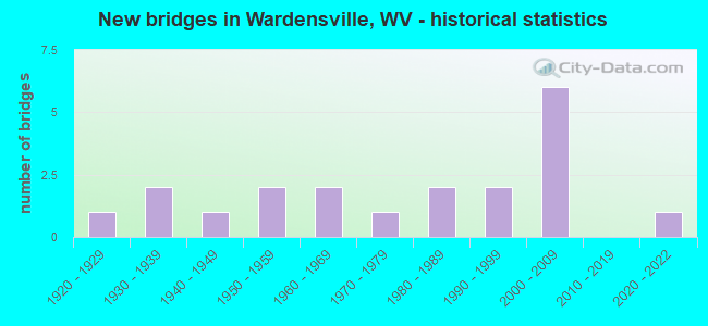
- New bridges - historical statistics
- 11920-1929
- 21930-1939
- 11940-1949
- 21950-1959
- 21960-1969
- 11970-1979
- 21980-1989
- 21990-1999
- 62000-2009
- 12020-2022

- Reconstructed bridges - Historical Statistics
- 31980-1989
- 11990-1999


- Bridge Condition - Deck
- 7.7%Very good
- 15.4%Good
- 46.2%Satisfactory
- 30.8%Fair

- Bridge Condition - Superstructure
- 7.7%Very good
- 7.7%Good
- 69.2%Satisfactory
- 15.4%Fair

- Bridge Condition - Substructure
- 7.7%Very good
- 15.4%Good
- 46.2%Satisfactory
- 15.4%Fair
- 15.4%Poor

- Bridge Condition - Channel
- 23.5%Very good
- 29.4%Good
- 29.4%Satisfactory
- 17.6%Fair

- Bridge Condition - Culverts
- 25.0%Good
- 25.0%Satisfactory
- 50.0%Fair
Find on map >> Show street view
Structure Number: 16A011, Location: 0.15 MI E OF CR 5/1 SLS (Lat: 39.081131, Lng: -78.579281), Route carried "on" structure: County highway 500, Year Built: 1959, Year Reconstructed: 1986, Status: Open, Structure Length: 1.20m (3.94ft), Average Daily Traffic: 550 (year 2018), Truck Traffic: 5%, Average Future Daily Traffic: 753 (year 2038), Design Load: HS 20, Features Intersected: WAITES RUN, Facility Carried by Structure: CR 05 SLS
Minimum Vertical Clearance: 30+ m (98+ ft), Kilometerpoint: 1.642, Lanes on structure: 2, Owner: State Highway Agency, Approaching Roadway Width: 7.0m (23.0ft), Skew: 2 degrees, Material/Design: Steel, Design/Construction: Stringer/Multi-beam, Number Of Spans In Main Unit: 1, Length of Maximum Span: 11.2m (36.7ft), Curb-To-Curb Width: 5.5m (18.0ft), Out-to-Out Width: 5.7m (18.7ft)
Condition: Deck: Fair, Superstructure: Satisfactory, Substructure: Poor, Channel: Satisfactory, Operating Rating: 59.0 metric tons, Method Used To Determine Operating Rating: Load Factor (LF), Inventory Rating: 35.4 metric tons, Method Used To Determine Inventory Rating: Load Factor (LF), Structural Evaluation: Meets minimum limits, Deck Geometry: High priority of replacement, Waterway Adequacy: Better than present minimum criteria, Approach Roadway Alignment: Equal to present minimum criteria, Length Of Structure Improvement: 1.22m (4.00ft), Designated Inspection Frequency: Every 24 months, Inspection Date: March 2020, Bridge Improvement Cost: $300,000, Roadway Improvement Cost: $10,000, Total Project Cost: $310,000 ( Estimate for 2020), Deck Structure Type: Wood or Timber, Wearing Surface/Protective System: Wearing Surface: Bituminous
Find on map >> Show street view
Structure Number: 16A012, Location: 1.11 MI S OF CR 05 SLS (Lat: 39.065061, Lng: -78.581169), Route carried "on" structure: County highway 501, Year Built: 1974, Status: Open, Structure Length: 1.27m (4.17ft), Average Daily Traffic: 600 (year 2020), Truck Traffic: 8%, Average Future Daily Traffic: 636 (year 2040), Features Intersected: WAITES RUN, Facility Carried by Structure: CR 5/1 SLS
Minimum Vertical Clearance: 30+ m (98+ ft), Kilometerpoint: 2.929, Lanes on structure: 2, Owner: State Highway Agency, Approaching Roadway Width: 7.6m (24.9ft), Skew: 3 degrees, Material/Design: Steel, Design/Construction: Girder and Floorbeam System, Number Of Spans In Main Unit: 1, Length of Maximum Span: 11.4m (37.4ft), Curb-To-Curb Width: 7.1m (23.3ft), Out-to-Out Width: 7.3m (24.0ft)
Condition: Deck: Satisfactory, Superstructure: Satisfactory, Substructure: Satisfactory, Channel: Fair, Operating Rating: 61.7 metric tons, Method Used To Determine Operating Rating: Load Factor (LF), Inventory Rating: 36.3 metric tons, Method Used To Determine Inventory Rating: Load Factor (LF), Structural Evaluation: Equal to present minimum criteria, Deck Geometry: Meets minimum limits, Waterway Adequacy: Equal to present minimum criteria, Approach Roadway Alignment: Equal to present minimum criteria, Designated Inspection Frequency: Every 24 months, Critical Feature Inspection Frequency: Every 24 months, Inspection Date: September 2021, Critical Feature Inspection Date: September 2021, Deck Structure Type: Wood or Timber, Wearing Surface/Protective System: Wearing Surface: Bituminous
Find on map >> Show street view
Structure Number: 16A013, Location: 3.10 MI S OF CR 05 SLS (Lat: 39.042739, Lng: -78.598300), Route carried "on" structure: County highway 501, Year Built: 1986, Status: Open, Structure Length: 1.12m (3.67ft), Average Daily Traffic: 300 (year 2018), Truck Traffic: 5%, Average Future Daily Traffic: 399 (year 2038), Design Load: HS 20, Features Intersected: WAITES RUN, Facility Carried by Structure: CR 5/1 SLS
Minimum Vertical Clearance: 30+ m (98+ ft), Kilometerpoint: 6.132, Lanes on structure: 2, Owner: State Highway Agency, Approaching Roadway Width: 5.2m (17.1ft), Skew: 4 degrees, Material/Design: Prestressed concrete, Design/Construction: Box Beam or Girders - Multiple, Number Of Spans In Main Unit: 1, Length of Maximum Span: 9.6m (31.5ft), Curb-To-Curb Width: 6.1m (20.0ft), Out-to-Out Width: 6.4m (21.0ft)
Condition: Deck: Satisfactory, Superstructure: Satisfactory, Substructure: Satisfactory, Channel: Satisfactory, Operating Rating: 61.7 metric tons, Method Used To Determine Operating Rating: Load Factor (LF), Inventory Rating: 37.2 metric tons, Method Used To Determine Inventory Rating: Load Factor (LF), Structural Evaluation: Equal to present minimum criteria, Deck Geometry: Meets minimum limits, Waterway Adequacy: Better than present minimum criteria, Approach Roadway Alignment: Equal to present minimum criteria, Designated Inspection Frequency: Every 48 months, Inspection Date: August 2020, Deck Structure Type: Other, Wearing Surface/Protective System: Wearing Surface: Bituminous, Deck Protection: Epoxy Coated Reinforcing
Find on map >> Show street view
Structure Number: 16A014, Location: 5.29 MI S OF CR 05 SLS (Lat: 39.015511, Lng: -78.605100), Route carried "on" structure: County highway 501, Year Built: 1986, Status: Open, Structure Length: 0.79m (2.59ft), Average Daily Traffic: 50 (year 2018), Average Future Daily Traffic: 67 (year 2038), Design Load: HS 20, Features Intersected: WAITES RUN, Facility Carried by Structure: CR 5/1 SLS
Minimum Vertical Clearance: 30+ m (98+ ft), Kilometerpoint: 9.656, Lanes on structure: 2, Owner: State Highway Agency, Approaching Roadway Width: 5.8m (19.0ft), Skew: 2 degrees, Material/Design: Steel, Design/Construction: Culvert, Number Of Spans In Main Unit: 1, Length of Maximum Span: 7.0m (23.0ft)
Condition: Channel: Satisfactory, Culverts: Satisfactory, Operating Rating: 71.7 metric tons, Method Used To Determine Operating Rating: Field evaluation and documented engineering judgment, Inventory Rating: 32.7 metric tons, Method Used To Determine Inventory Rating: Field evaluation and documented engineering judgment, Structural Evaluation: Equal to present minimum criteria, Waterway Adequacy: Equal to present minimum criteria, Approach Roadway Alignment: Better than present minimum criteria, Designated Inspection Frequency: Every 48 months, Inspection Date: August 2020
Find on map >> Show street view
Structure Number: 16A05, Location: 1.39 MI N OF CR 16 SLS (Lat: 39.044511, Lng: -78.638100), Route carried "on" structure: County highway 2310, Year Built: 1954, Status: Open, Structure Length: 0.68m (2.23ft), Average Daily Traffic: 400 (year 2019), Truck Traffic: 5%, Average Future Daily Traffic: 520 (year 2039), Features Intersected: Halfmoon Run, Facility Carried by Structure: CR 23/10 SLS
Minimum Vertical Clearance: 30+ m (98+ ft), Kilometerpoint: 15.047, Lanes on structure: 2, Owner: State Highway Agency, Approaching Roadway Width: 7.3m (24.0ft), Skew: 2 degrees, Material/Design: Steel, Design/Construction: Culvert, Number Of Spans In Main Unit: 2, Length of Maximum Span: 3.2m (10.5ft)
Condition: Channel: Satisfactory, Culverts: Fair, Operating Rating: 53.5 metric tons, Method Used To Determine Operating Rating: Field evaluation and documented engineering judgment, Inventory Rating: 24.5 metric tons, Method Used To Determine Inventory Rating: Field evaluation and documented engineering judgment, Structural Evaluation: Somewhat better than minimum adequacy, Waterway Adequacy: Equal to present minimum criteria, Approach Roadway Alignment: Better than present minimum criteria, Designated Inspection Frequency: Every 24 months, Inspection Date: October 2020
Find on map >> Show street view
Structure Number: 16A052, Location: 0.55 MI N OF WV 259 F (Lat: 39.095650, Lng: -78.594900), Route carried "on" structure: County highway 2313, Year Built: 1961, Year Reconstructed: 1988, Status: Open, Structure Length: 0.94m (3.08ft), Average Daily Traffic: 156 (year 2017), Truck Traffic: 5%, Average Future Daily Traffic: 214 (year 2037), Design Load: HS 20, Features Intersected: MOORES RUN, Facility Carried by Structure: COUNTY ROAD 23/13
Minimum Vertical Clearance: 30+ m (98+ ft), Kilometerpoint: 0.885, Lanes on structure: 2, Owner: State Highway Agency, Approaching Roadway Width: 5.5m (18.0ft), Skew: 3 degrees, Material/Design: Prestressed concrete, Design/Construction: Box Beam or Girders - Multiple, Number Of Spans In Main Unit: 1, Length of Maximum Span: 8.1m (26.6ft), Curb-To-Curb Width: 6.1m (20.0ft), Out-to-Out Width: 6.5m (21.3ft)
Condition: Deck: Good, Superstructure: Good, Substructure: Satisfactory, Channel: Good, Operating Rating: 88.9 metric tons, Method Used To Determine Operating Rating: Load Factor (LF), Inventory Rating: 55.3 metric tons, Method Used To Determine Inventory Rating: Load Factor (LF), Structural Evaluation: Equal to present minimum criteria, Deck Geometry: Meets minimum limits, Waterway Adequacy: Equal to present minimum criteria, Approach Roadway Alignment: Equal to present desirable criteria, Designated Inspection Frequency: Every 48 months, Inspection Date: September 2018, Deck Structure Type: Other, Wearing Surface/Protective System: Wearing Surface: Bituminous, Deck Protection: Epoxy Coated Reinforcing
Find on map >> Show street view
Structure Number: 16A063, Location: 0.47 MI E OF CR 23/9 SLS (Lat: 39.064781, Lng: -78.655169), Route carried "on" structure: County highway 5520, Year Built: 1931, Year Reconstructed: 1994, Status: Posted for load, Structure Length: 4.40m (14.44ft), Average Daily Traffic: 90 (year 2019), Average Future Daily Traffic: 122 (year 2039), Design Load: H 20, Features Intersected: LOST RIVER, Facility Carried by Structure: CR 55/20
Minimum Vertical Clearance: 4.39m (14.40ft), Kilometerpoint: 39.525, Lanes on structure: 2, Owner: State Highway Agency, Approaching Roadway Width: 9.1m (29.9ft), Material/Design: Steel, Design/Construction: Truss - Thru, Number Of Spans In Main Unit: 1, Length of Maximum Span: 42.7m (140.1ft), Curb-To-Curb Width: 7.4m (24.3ft), Out-to-Out Width: 7.6m (24.9ft)
Condition: Deck: Fair, Superstructure: Fair, Substructure: Poor, Channel: Good, Operating Rating: 39.9 metric tons, Method Used To Determine Operating Rating: Load Factor (LF), Inventory Rating: 23.6 metric tons, Method Used To Determine Inventory Rating: Load Factor (LF), Structural Evaluation: Meets minimum limits, Deck Geometry: High priority of corrective action, Waterway Adequacy: Equal to present desirable criteria, Approach Roadway Alignment: High priority of corrective action, Bridge Posting: Required (Relationship of Operating Rating to Maximum Legal Load: 0.1 - 9.9% below), Designated Inspection Frequency: Every 24 months, Critical Feature Inspection Frequency: Every 24 months, Inspection Date: May 2021, Critical Feature Inspection Date: May 2021, Deck Structure Type: Closed Grating
Find on map >> Show street view
Structure Number: 16A064, Location: 0.36 MI W OF CR 23/10 SLS (Lat: 39.075950, Lng: -78.604669), Route carried "on" structure: State highway 5500, Year Built: 1928, Status: Open, Structure Length: 3.07m (10.07ft), Average Daily Traffic: 4,500 (year 2020), Truck Traffic: 16%, Average Future Daily Traffic: 6,525 (year 2040), Features Intersected: TROUT RUN, Facility Carried by Structure: WV 55 X
Minimum Vertical Clearance: 30+ m (98+ ft), Kilometerpoint: 61.155, Lanes on structure: 2, Base Highway Network: Yes, Owner: State Highway Agency, Approaching Roadway Width: 9.1m (29.9ft), Skew: 4 degrees, Material/Design: Concrete, Design/Construction: Slab, Number Of Spans In Main Unit: 1, Number Of Approach Spans: 2, Length of Maximum Span: 9.5m (31.2ft), Curb or Sidewalk Widths: Left: 0.1m (0.3ft), Right: 0.1m (0.3ft), Curb-To-Curb Width: 7.6m (24.9ft), Out-to-Out Width: 7.8m (25.6ft)
Condition: Deck: Fair, Superstructure: Fair, Substructure: Fair, Channel: Fair, Operating Rating: 50.8 metric tons, Method Used To Determine Operating Rating: Load Factor (LF), Inventory Rating: 30.8 metric tons, Method Used To Determine Inventory Rating: Load Factor (LF), Structural Evaluation: Somewhat better than minimum adequacy, Deck Geometry: High priority of replacement, Waterway Adequacy: Equal to present minimum criteria, Approach Roadway Alignment: Equal to present desirable criteria, Length Of Structure Improvement: 3.05m (10.01ft), Designated Inspection Frequency: Every 24 months, Other Special Inspection Frequency: Every 12 months, Inspection Date: December 2020, Other Special Inspection Date: December 2021, Bridge Improvement Cost: $1,250,000, Roadway Improvement Cost: $100,000, Total Project Cost: $1,350,000 ( Estimate for 2019), Deck Structure Type: Concrete Cast-file-Place, Wearing Surface/Protective System: Wearing Surface: Bituminous
Find on map >> Show street view
Structure Number: 16A066, Location: 0.38 MI W OF CR 55/1 SLS (Lat: 39.093889, Lng: -78.569311), Route carried "on" structure: State highway 5500, Year Built: 1941, Status: Open, Structure Length: 0.86m (2.82ft), Average Daily Traffic: 2,800 (year 2018), Truck Traffic: 17%, Average Future Daily Traffic: 3,836 (year 2038), Features Intersected: SLATE ROCK RUN, Facility Carried by Structure: WV 55 X
Minimum Vertical Clearance: 30+ m (98+ ft), Kilometerpoint: 65.211, Lanes on structure: 2, Base Highway Network: Yes, Owner: State Highway Agency, Approaching Roadway Width: 9.1m (29.9ft), Skew: 4 degrees, Material/Design: Concrete, Design/Construction: Culvert, Number Of Spans In Main Unit: 1, Length of Maximum Span: 8.6m (28.2ft)
Condition: Channel: Fair, Culverts: Fair, Operating Rating: 63.5 metric tons, Method Used To Determine Operating Rating: Field evaluation and documented engineering judgment, Inventory Rating: 29.0 metric tons, Method Used To Determine Inventory Rating: Field evaluation and documented engineering judgment, Structural Evaluation: Somewhat better than minimum adequacy, Waterway Adequacy: Equal to present minimum criteria, Approach Roadway Alignment: Equal to present desirable criteria, Length Of Structure Improvement: 0.91m (2.99ft), Designated Inspection Frequency: Every 24 months, Inspection Date: May 2020, Bridge Improvement Cost: $400,000, Roadway Improvement Cost: $20,000, Total Project Cost: $420,000 ( Estimate for 2016)
Find on map >> Show street view
Structure Number: 16A093, Location: 0.66 MI N OF CR 23/13 SLS (Lat: 39.102750, Lng: -78.580711), Route carried "on" structure: State highway 259, Year Built: 1931, Status: Open, Structure Length: 1.01m (3.31ft), Average Daily Traffic: 3,700 (year 2019), Truck Traffic: 17%, Average Future Daily Traffic: 4,810 (year 2039), Features Intersected: MOORES RUN
Minimum Vertical Clearance: 30+ m (98+ ft), Kilometerpoint: 53.816, Lanes on structure: 2, Owner: State Highway Agency, Approaching Roadway Width: 10.1m (33.1ft), Material/Design: Concrete, Design/Construction: Slab, Number Of Spans In Main Unit: 1, Length of Maximum Span: 8.9m (29.2ft), Curb or Sidewalk Widths: Left: 0.2m (0.7ft), Right: 0.2m (0.7ft), Curb-To-Curb Width: 9.0m (29.5ft), Out-to-Out Width: 10.1m (33.1ft)
Condition: Deck: Satisfactory, Superstructure: Satisfactory, Substructure: Fair, Channel: Satisfactory, Operating Rating: 63.5 metric tons, Method Used To Determine Operating Rating: Field evaluation and documented engineering judgment, Inventory Rating: 29.0 metric tons, Method Used To Determine Inventory Rating: Field evaluation and documented engineering judgment, Structural Evaluation: Somewhat better than minimum adequacy, Deck Geometry: Meets minimum limits, Waterway Adequacy: Equal to present minimum criteria, Approach Roadway Alignment: Equal to present desirable criteria, Length Of Structure Improvement: 1.83m (6.00ft), Designated Inspection Frequency: Every 24 months, Inspection Date: January 2021, Bridge Improvement Cost: $500,000, Roadway Improvement Cost: $250,000, Total Project Cost: $750,000 ( Estimate for 2017), Deck Structure Type: Concrete Cast-file-Place, Wearing Surface/Protective System: Wearing Surface: Bituminous
Find on map >> Show street view
Structure Number: 16A101, Location: 0.74 MI S OF WV55 X (Lat: 39.069061, Lng: -78.628419), Route carried "on" structure: County highway 2312, Year Built: 1961, Year Reconstructed: 1996, Status: Open, Structure Length: 1.23m (4.04ft), Average Daily Traffic: 250 (year 2019), Truck Traffic: 5%, Average Future Daily Traffic: 333 (year 2039), Design Load: HS 20, Features Intersected: TROUT RUN, Facility Carried by Structure: CR 23/12 SLS
Minimum Vertical Clearance: 30+ m (98+ ft), Kilometerpoint: 1.529, Lanes on structure: 2, Owner: State Highway Agency, Approaching Roadway Width: 4.9m (16.1ft), Skew: 2 degrees, Material/Design: Steel, Design/Construction: Stringer/Multi-beam, Number Of Spans In Main Unit: 1, Length of Maximum Span: 11.0m (36.1ft), Curb-To-Curb Width: 5.9m (19.4ft), Out-to-Out Width: 6.1m (20.0ft)
Condition: Deck: Fair, Superstructure: Satisfactory, Substructure: Satisfactory, Channel: Good, Operating Rating: 57.1 metric tons, Method Used To Determine Operating Rating: Load Factor (LF), Inventory Rating: 34.5 metric tons, Method Used To Determine Inventory Rating: Load Factor (LF), Structural Evaluation: Equal to present minimum criteria, Deck Geometry: High priority of corrective action, Waterway Adequacy: Somewhat better than minimum adequacy, Approach Roadway Alignment: Equal to present minimum criteria, Length Of Structure Improvement: 1.22m (4.00ft), Designated Inspection Frequency: Every 24 months, Inspection Date: March 2021, Bridge Improvement Cost: $80,000, Roadway Improvement Cost: $10,000, Total Project Cost: $90,000 ( Estimate for 2015), Deck Structure Type: Wood or Timber
Find on map >> Show street view
Structure Number: 16A103, Location: 0.03 MI N OF CR 23/13 SLS (Lat: 39.098319, Lng: -78.602900), Route carried "on" structure: State lands road 81400, Year Built: 1997, Status: Open, Structure Length: 0.91m (2.99ft), Average Daily Traffic: 10 (year 2019), Average Future Daily Traffic: 13 (year 2039), Design Load: HS 25 or greater, Features Intersected: MOORES RUN, Facility Carried by Structure: P&F ROAD 814
Minimum Vertical Clearance: 30+ m (98+ ft), Kilometerpoint: 0.048, Lanes on structure: 2, Owner: State Park, Forest, or Reservation Agency, Maintenance Responsibility: State Highway Agency, Approaching Roadway Width: 4.9m (16.1ft), Skew: 2 degrees, Material/Design: Concrete, Design/Construction: Culvert, Number Of Spans In Main Unit: 2, Length of Maximum Span: 3.7m (12.1ft), Curb-To-Curb Width: 7.3m (24.0ft), Out-to-Out Width: 14.8m (48.6ft)
Condition: Channel: Good, Culverts: Good, Operating Rating: 88.9 metric tons, Method Used To Determine Operating Rating: Field evaluation and documented engineering judgment, Inventory Rating: 40.8 metric tons, Method Used To Determine Inventory Rating: Field evaluation and documented engineering judgment, Structural Evaluation: Better than present minimum criteria, Deck Geometry: Equal to present minimum criteria, Waterway Adequacy: Better than present minimum criteria, Approach Roadway Alignment: Equal to present desirable criteria, Designated Inspection Frequency: Every 48 months, Inspection Date: May 2021
Find on map >> Show street view
Structure Number: 16A111, Location: 0.11 MI S OF CR 23/13 SLS (Lat: 39.092161, Lng: -78.586300), Route carried "on" structure: State highway 25900, Year Built: 1999, Status: Open, Structure Length: 6.75m (22.15ft), Average Daily Traffic: 3,600 (year 2018), Truck Traffic: 17%, Average Future Daily Traffic: 4,680 (year 2038), Design Load: HS 25 or greater, Features Intersected: CACAPON RIVER, Facility Carried by Structure: WV 259 F
Minimum Vertical Clearance: 30+ m (98+ ft), Kilometerpoint: 52.529, Lanes on structure: 2, Owner: State Highway Agency, Approaching Roadway Width: 7.9m (25.9ft), Material/Design: Prestressed concrete continuous, Design/Construction: Stringer/Multi-beam, Number Of Spans In Main Unit: 1, Number Of Approach Spans: 2, Length of Maximum Span: 27.4m (89.9ft), Curb-To-Curb Width: 10.2m (33.5ft), Out-to-Out Width: 11.2m (36.7ft)
Condition: Deck: Satisfactory, Superstructure: Satisfactory, Substructure: Good, Channel: Good, Operating Rating: 59.9 metric tons, Method Used To Determine Operating Rating: Load Factor (LF), Inventory Rating: 36.3 metric tons, Method Used To Determine Inventory Rating: Load Factor (LF), Structural Evaluation: Equal to present minimum criteria, Deck Geometry: Meets minimum limits, Waterway Adequacy: Equal to present desirable criteria, Approach Roadway Alignment: Equal to present desirable criteria, Designated Inspection Frequency: Every 48 months, Inspection Date: May 2020, Deck Structure Type: Concrete Cast-file-Place, Wearing Surface/Protective System: Deck Protection: Epoxy Coated Reinforcing
Find on map >> Show street view
Structure Number: 16A132, Location: 1.58 MILE EAST OF CR 23/8 (Lat: 39.065811, Lng: -78.663731), Route carried "on" structure: US 4800, Year Built: 2004, Status: Open, Structure Length: 16.08m (52.76ft), Average Daily Traffic: 2,300 (year 2020), Truck Traffic: 12%, Average Future Daily Traffic: 2,760 (year 2040), Design Load: HS 25 or greater, Features Intersected: Sauerkraut Run & CR 23/9, Facility Carried by Structure: US 48 X Corridor H
Minimum Vertical Clearance: 30+ m (98+ ft), Kilometerpoint: 45.931, Lanes on structure: 2, Lanes under structure: 2, Base Highway Network: Yes, Owner: State Highway Agency, Approaching Roadway Width: 10.1m (33.1ft), Material/Design: Steel continuous, Design/Construction: Stringer/Multi-beam, Number Of Spans In Main Unit: 1, Number Of Approach Spans: 2, Length of Maximum Span: 66.0m (216.5ft), Curb-To-Curb Width: 10.2m (33.5ft), Out-to-Out Width: 10.9m (35.8ft)
Condition: Deck: Satisfactory, Superstructure: Satisfactory, Substructure: Good, Channel: Very good, Operating Rating: 87.1 metric tons, Method Used To Determine Operating Rating: Load Factor (LF), Inventory Rating: 52.6 metric tons, Method Used To Determine Inventory Rating: Load Factor (LF), Structural Evaluation: Equal to present minimum criteria, Deck Geometry: Somewhat better than minimum adequacy, Underclear: Superior to present desirable criteria, Waterway Adequacy: Superior to present desirable criteria, Approach Roadway Alignment: Equal to present desirable criteria, Designated Inspection Frequency: Every 24 months, Inspection Date: September 2021, Deck Structure Type: Concrete Cast-file-Place, Wearing Surface/Protective System: Wearing Surface: Latex Concrete, Deck Protection: Epoxy Coated Reinforcing
Find on map >> Show street view
Structure Number: 16A138, Location: 2.04 MI E OF CR 23/8 (Lat: 39.066069, Lng: -78.654900), Route carried "on" structure: US 4800, Year Built: 2005, Status: Open, Structure Length: 29.10m (95.47ft), Average Daily Traffic: 2,500 (year 2019), Truck Traffic: 8%, Average Future Daily Traffic: 3,625 (year 2039), Design Load: HS 25 or greater, Features Intersected: CR 55/20 & Lost River, Facility Carried by Structure: US 48 (X)
Minimum Vertical Clearance: 30+ m (98+ ft), Kilometerpoint: 46.671, Lanes on structure: 2, Lanes under structure: 2, Base Highway Network: Yes, Owner: State Highway Agency, Approaching Roadway Width: 10.1m (33.1ft), Material/Design: Steel continuous, Design/Construction: Stringer/Multi-beam, Number Of Spans In Main Unit: 1, Number Of Approach Spans: 4, Length of Maximum Span: 68.0m (223.1ft), Curb-To-Curb Width: 10.2m (33.5ft), Out-to-Out Width: 10.9m (35.8ft)
Condition: Deck: Satisfactory, Superstructure: Satisfactory, Substructure: Satisfactory, Channel: Very good, Operating Rating: 64.4 metric tons, Method Used To Determine Operating Rating: Load and Resistance Factor (LRFR), Inventory Rating: 49.9 metric tons, Method Used To Determine Inventory Rating: Load and Resistance Factor (LRFR), Structural Evaluation: Equal to present minimum criteria, Deck Geometry: Somewhat better than minimum adequacy, Underclear: Equal to present minimum criteria, Waterway Adequacy: Superior to present desirable criteria, Approach Roadway Alignment: Better than present minimum criteria, Designated Inspection Frequency: Every 24 months, Inspection Date: December 2020, Deck Structure Type: Concrete Cast-file-Place, Wearing Surface/Protective System: Wearing Surface: Latex Concrete, Deck Protection: Epoxy Coated Reinforcing
Find on map >> Show street view
Structure Number: 16A139, Location: 2.04 MI E OF CR 23/8 (Lat: 39.066419, Lng: -78.654731), Route carried "on" structure: US 4800, Year Built: 2004, Status: Open, Structure Length: 33.20m (108.92ft), Average Daily Traffic: 2,450 (year 2018), Truck Traffic: 8%, Average Future Daily Traffic: 3,553 (year 2038), Design Load: HS 25 or greater, Features Intersected: CR 55/20 & Lost River, Facility Carried by Structure: US 48 (X)
Minimum Vertical Clearance: 30+ m (98+ ft), Kilometerpoint: 46.671, Lanes on structure: 2, Lanes under structure: 2, Base Highway Network: Yes, Owner: State Highway Agency, Approaching Roadway Width: 11.6m (38.1ft), Material/Design: Steel continuous, Design/Construction: Stringer/Multi-beam, Number Of Spans In Main Unit: 2, Number Of Approach Spans: 3, Length of Maximum Span: 78.0m (255.9ft), Curb-To-Curb Width: 10.1m (33.1ft), Out-to-Out Width: 10.9m (35.8ft)
Condition: Deck: Good, Superstructure: Satisfactory, Substructure: Satisfactory, Channel: Very good, Operating Rating: 52.6 metric tons, Method Used To Determine Operating Rating: Load and Resistance Factor (LRFR), Inventory Rating: 40.8 metric tons, Method Used To Determine Inventory Rating: Load and Resistance Factor (LRFR), Structural Evaluation: Equal to present minimum criteria, Deck Geometry: Somewhat better than minimum adequacy, Underclear: Meets minimum limits, Waterway Adequacy: Superior to present desirable criteria, Approach Roadway Alignment: Equal to present desirable criteria, Designated Inspection Frequency: Every 24 months, Inspection Date: July 2020, Deck Structure Type: Concrete Cast-file-Place, Wearing Surface/Protective System: Wearing Surface: Latex Concrete, Deck Protection: Epoxy Coated Reinforcing
Find on map >> Show street view
Structure Number: 16A162, Location: 0.15 miles E. of CR 259/1 (Lat: 39.088600, Lng: -78.583511), Route carried "on" structure: State highway 5500, Year Built: 2020, Status: Open, Structure Length: 4.70m (15.42ft), Average Daily Traffic: 2,400 (year 2019), Truck Traffic: 17%, Average Future Daily Traffic: 3,480 (year 2039), Design Load: HL 93, Features Intersected: Waites Run, Facility Carried by Structure: WV 55 X
Minimum Vertical Clearance: 30+ m (98+ ft), Kilometerpoint: 63.827, Lanes on structure: 2, Base Highway Network: Yes, Owner: State Highway Agency, Approaching Roadway Width: 7.0m (23.0ft), Skew: 3 degrees, Material/Design: Steel, Design/Construction: Stringer/Multi-beam, Number Of Spans In Main Unit: 1, Length of Maximum Span: 47.0m (154.2ft), Curb-To-Curb Width: 9.1m (29.9ft), Out-to-Out Width: 9.9m (32.5ft)
Condition: Deck: Very good, Superstructure: Very good, Substructure: Very good, Channel: Very good, Operating Rating: 54.4 metric tons, Method Used To Determine Operating Rating: Load and Resistance Factor (LRFR), Inventory Rating: 41.7 metric tons, Method Used To Determine Inventory Rating: Load and Resistance Factor (LRFR), Structural Evaluation: Equal to present desirable criteria, Deck Geometry: Meets minimum limits, Waterway Adequacy: Equal to present minimum criteria, Approach Roadway Alignment: Equal to present minimum criteria, Designated Inspection Frequency: Every 24 months, Inspection Date: December 2020, Deck Structure Type: Concrete Cast-file-Place
Find on map >> Show street view
Structure Number: 16A132, Location: 1.58 MILE EAST OF CR 23/8 (Lat: 39.065811, Lng: -78.663567), Route carried "under" structure: County highway 2309, Year Built: 2004, Structure Length: 0. m, Average Daily Traffic: 50 (year 2020), Features Intersected: Sauerkraut Run & CR 23/9, Facility Carried by Structure: US 48 X Corridor H
Minimum Vertical Clearance: 27.43m (89.99ft), Kilometerpoint: 0.145, Lanes on structure: 2, Lanes under structure: 2, Length of Maximum Span: 66.0m (216.5ft)
Find on map >> Show street view
Structure Number: 16A138, Location: 2.04 MI E OF CR 23/8 (Lat: 39.066131, Lng: -78.654731), Route carried "under" structure: County highway 5520, Year Built: 2005, Structure Length: 0. m, Average Daily Traffic: 90 (year 2019), Truck Traffic: 14%, Features Intersected: CR 55/20 & Lost River, Facility Carried by Structure: US 48 (X)
Minimum Vertical Clearance: 27.99m (91.83ft), Kilometerpoint: 40.024, Lanes on structure: 2, Lanes under structure: 2, Length of Maximum Span: 68.0m (223.1ft)
Find on map >> Show street view
Structure Number: 16A139, Location: 2.04 MI E OF CR 23/8 (Lat: 39.066419, Lng: -78.654731), Route carried "under" structure: County highway 5520, Year Built: 2004, Structure Length: 0. m, Average Daily Traffic: 90 (year 2018), Truck Traffic: 5%, Features Intersected: CR 55/20 & Lost River, Facility Carried by Structure: US 48 (X)
Minimum Vertical Clearance: 27.74m (91.01ft), Kilometerpoint: 39.686, Lanes on structure: 2, Lanes under structure: 2, Length of Maximum Span: 78.0m (255.9ft)