Bridge Statistics for Warrior Run, Pennsylvania (PA)
Condition, Traffic, Stress, Structural Evaluation, Project Costs
- National Bridge Inventory (NBI) Statistics
- 10Number of bridges
- 141ft / 42.6mTotal length
- $6,067,000Total costs
- 55,237Total average daily traffic
- 4,170Total average daily truck traffic
- National Bridge Inventory (NBI) Registered Bridges for Warrior Run
- No street view available for this location
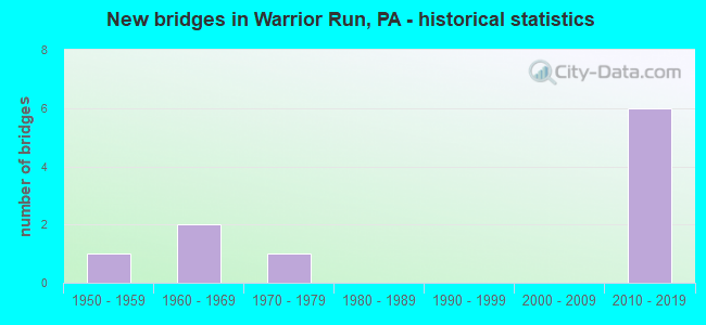
- New bridges - historical statistics
- 11950-1959
- 21960-1969
- 11970-1979
- 62010-2019

- Reconstructed bridges - Historical Statistics
- 12000-2009
- 12010-2019


- Bridge Condition - Deck
- 50.0%Very good
- 25.0%Good
- 25.0%Satisfactory

- Bridge Condition - Superstructure
- 75.0%Good
- 25.0%Satisfactory

- Bridge Condition - Substructure
- 25.0%Excellent
- 50.0%Good
- 25.0%Satisfactory

- Bridge Condition - Channel
- 50.0%Very good
- 25.0%Satisfactory
- 25.0%Poor
Find on map >> Show street view
Structure Number: 21212, Location: MARTIC FORGE (Lat: 39.905617, Lng: -76.328136), Route carried "on" structure: State highway 324, Year Built: 1970, Year Reconstructed: 2013, Status: Open, Structure Length: 4.85m (15.91ft), Average Daily Traffic: 540 (year 2022), Truck Traffic: 6%, Average Future Daily Traffic: 970 (year 2032), Design Load: HS 20, Features Intersected: PEQUEA CREEK
Minimum Vertical Clearance: 30+ m (98+ ft), Kilometerpoint: 4.926, Lanes on structure: 2, Owner: State Highway Agency, Approaching Roadway Width: 17.1m (56.1ft), Material/Design: Prestressed concrete, Design/Construction: Stringer/Multi-beam, Number Of Spans In Main Unit: 2, Length of Maximum Span: 23.2m (76.1ft), Curb or Sidewalk Widths: Left: 0.2m (0.7ft), Right: 0.2m (0.7ft), Curb-To-Curb Width: 13.4m (44.0ft), Out-to-Out Width: 14.6m (47.9ft)
Condition: Deck: Satisfactory, Superstructure: Good, Substructure: Good, Channel: Satisfactory, Operating Rating: 68.0 metric tons, Method Used To Determine Operating Rating: Load Factor (LF), Inventory Rating: 17.2 metric tons, Method Used To Determine Inventory Rating: Load Factor (LF), Structural Evaluation: Meets minimum limits, Deck Geometry: Superior to present desirable criteria, Waterway Adequacy: Equal to present minimum criteria, Approach Roadway Alignment: Equal to present desirable criteria, Length Of Structure Improvement: 5.50m (18.04ft), Designated Inspection Frequency: Every 24 months, Inspection Date: June 2020, Deck Structure Type: Concrete Cast-file-Place, Wearing Surface/Protective System: Wearing Surface: Monolithic Concrete, Deck Protection: Epoxy Coated Reinforcing
Find on map >> Show street view
Structure Number: 23622, Location: HANOVER TWP 1 M S SR 2002 (Lat: 41.199822, Lng: -75.965761), Route carried "on" structure: State highway 29, Year Built: 1969, Year Reconstructed: 2010, Status: Open, Structure Length: 10.49m (34.42ft), Average Daily Traffic: 11,271 (year 2020), Truck Traffic: 8%, Average Future Daily Traffic: 20,532 (year 2032), Design Load: HS 20, Features Intersected: TWP RD, ABAND. R/R, CRK
Minimum Vertical Clearance: 30+ m (98+ ft), Kilometerpoint: 4.942, Lanes on structure: 2, Lanes under structure: 2, Base Highway Network: Yes, Owner: State Highway Agency, Approaching Roadway Width: 25.0m (82.0ft), Skew: 34 degrees, Material/Design: Steel, Design/Construction: Stringer/Multi-beam, Number Of Spans In Main Unit: 4, Length of Maximum Span: 30.8m (101.0ft), Curb or Sidewalk Widths: Left: 0.2m (0.7ft), Right: 0.2m (0.7ft), Curb-To-Curb Width: 24.7m (81.0ft), Out-to-Out Width: 26.8m (87.9ft)
Condition: Deck: Very good, Superstructure: Satisfactory, Substructure: Satisfactory, Channel: Very good, Operating Rating: 53.5 metric tons, Method Used To Determine Operating Rating: Load Factor (LF), Inventory Rating: 32.7 metric tons, Method Used To Determine Inventory Rating: Load Factor (LF), Structural Evaluation: Equal to present minimum criteria, Deck Geometry: Superior to present desirable criteria, Underclear: Superior to present desirable criteria, Waterway Adequacy: Superior to present desirable criteria, Approach Roadway Alignment: Equal to present desirable criteria, Length Of Structure Improvement: 10.50m (34.45ft), Designated Inspection Frequency: Every 24 months, Inspection Date: November 2020, Bridge Improvement Cost: $314,000, Roadway Improvement Cost: $924,000, Total Project Cost: $4,236,000, Deck Structure Type: Concrete Cast-file-Place, Wearing Surface/Protective System: Wearing Surface: Monolithic Concrete, Deck Protection: Epoxy Coated Reinforcing
Find on map >> Show street view
Structure Number: 24058, Location: HANOVER TWP 1 M E TR 29 (Lat: 41.210517, Lng: -75.962992), Route carried "on" structure: State highway , Year Built: 1952, Status: Open, Structure Length: 1.37m (4.49ft), Average Daily Traffic: 11,505 (year 2021), Truck Traffic: 6%, Average Future Daily Traffic: 12,863 (year 2032), Design Load: HS 20, Features Intersected: WARRIOR CREEK, Facility Carried by Structure: SR 2002
Minimum Vertical Clearance: 30+ m (98+ ft), Kilometerpoint: 3.528, Lanes on structure: 4, Base Highway Network: Yes, Owner: State Highway Agency, Approaching Roadway Width: 24.1m (79.1ft), Skew: 26 degrees, Material/Design: Concrete, Design/Construction: Culvert, Number Of Spans In Main Unit: 1, Length of Maximum Span: 13.7m (44.9ft)
Condition: Channel: Poor, Culverts: Fair, Operating Rating: 49.0 metric tons, Method Used To Determine Operating Rating: Field evaluation and documented engineering judgment, Inventory Rating: 32.7 metric tons, Method Used To Determine Inventory Rating: Field evaluation and documented engineering judgment, Structural Evaluation: Somewhat better than minimum adequacy, Waterway Adequacy: Better than present minimum criteria, Approach Roadway Alignment: Equal to present desirable criteria, Length Of Structure Improvement: 0.90m (2.95ft), Designated Inspection Frequency: Every 24 months, Inspection Date: November 2020, Bridge Improvement Cost: $136,000, Roadway Improvement Cost: $724,000, Total Project Cost: $1,831,000
Find on map >> Show street view
Structure Number: 54753, Location: SR 3046 OVER SR 29 (Lat: 41.199333, Lng: -75.964792), Route carried "on" structure: State highway , Year Built: 2017, Status: Open, Structure Length: 21.34m (70.01ft), Average Daily Traffic: 3,909 (year 2020), Truck Traffic: 9%, Average Future Daily Traffic: 244 (year 2038), Design Load: HL 93, Features Intersected: SR 29 & DUNDEE ROAD, Facility Carried by Structure: SR 3046
Minimum Vertical Clearance: 30+ m (98+ ft), Kilometerpoint: 1.244, Lanes on structure: 2, Lanes under structure: 8, Owner: State Highway Agency, Approaching Roadway Width: 7.3m (24.0ft), Material/Design: Prestressed concrete, Design/Construction: Stringer/Multi-beam, Number Of Spans In Main Unit: 6, Length of Maximum Span: 36.6m (120.1ft), Curb or Sidewalk Widths: Left: 0.2m (0.7ft), Right: 0.2m (0.7ft), Curb-To-Curb Width: 7.3m (24.0ft), Out-to-Out Width: 12.6m (41.3ft)
Condition: Deck: Good, Superstructure: Good, Substructure: Good, Channel: Very good, Operating Rating: 48.6 metric tons, Method Used To Determine Operating Rating: Assigned ratings based on Load and Resistance Factor Design (LRFD) reported by rating factor (RF) using HL93 loadings, Inventory Rating: 37.6 metric tons, Method Used To Determine Inventory Rating: Assigned ratings based on Load and Resistance Factor Design (LRFD) reported by rating factor (RF) using HL93 loadings, Structural Evaluation: Better than present minimum criteria, Deck Geometry: High priority of replacement, Underclear: Equal to present minimum criteria, Waterway Adequacy: Superior to present desirable criteria, Approach Roadway Alignment: Equal to present desirable criteria, Designated Inspection Frequency: Every 48 months, Inspection Date: January 2020, Deck Structure Type: Concrete Cast-file-Place, Wearing Surface/Protective System: Wearing Surface: Monolithic Concrete, Deck Protection: Epoxy Coated Reinforcing
Find on map >> Show street view
Structure Number: 54755, Location: HANOVER TWP OVER TR 29 (Lat: 41.203194, Lng: -75.945722), Route carried "on" structure: State highway , Year Built: 2017, Status: Open, Structure Length: 4.57m (14.99ft), Average Daily Traffic: 5,370 (year 2022), Truck Traffic: 5%, Average Future Daily Traffic: 1,082 (year 2038), Design Load: HL 93, Features Intersected: SR 0029 TR 29, Facility Carried by Structure: SR 2008 MIDDLE RD
Minimum Vertical Clearance: 30+ m (98+ ft), Kilometerpoint: 6.013, Lanes on structure: 2, Lanes under structure: 4, Owner: State Highway Agency, Approaching Roadway Width: 12.2m (40.0ft), Skew: 20 degrees, Material/Design: Prestressed concrete, Design/Construction: Stringer/Multi-beam, Number Of Spans In Main Unit: 1, Length of Maximum Span: 45.7m (149.9ft), Curb or Sidewalk Widths: Left: 0.2m (0.7ft), Right: 0.2m (0.7ft), Curb-To-Curb Width: 12.2m (40.0ft), Out-to-Out Width: 13.2m (43.3ft)
Condition: Deck: Very good, Superstructure: Good, Substructure: Excellent, Operating Rating: 54.8 metric tons, Method Used To Determine Operating Rating: Assigned ratings based on Load and Resistance Factor Design (LRFD) reported by rating factor (RF) using HL93 loadings, Inventory Rating: 38.9 metric tons, Method Used To Determine Inventory Rating: Assigned ratings based on Load and Resistance Factor Design (LRFD) reported by rating factor (RF) using HL93 loadings, Structural Evaluation: Better than present minimum criteria, Deck Geometry: Somewhat better than minimum adequacy, Underclear: Meets minimum limits, Approach Roadway Alignment: Equal to present desirable criteria, Designated Inspection Frequency: Every 48 months, Inspection Date: December 2019, Deck Structure Type: Concrete Cast-file-Place, Wearing Surface/Protective System: Wearing Surface: Monolithic Concrete, Deck Protection: Epoxy Coated Reinforcing
Find on map >> Show street view
Structure Number: 23622, Location: HANOVER TWP 1 M S SR 2002 (Lat: 41.199822, Lng: -75.965761), Route carried "under" structure: Other road , Year Built: 1969, Structure Length: 0. m, Average Daily Traffic: 100 (year 2003), Truck Traffic: 10%, Features Intersected: TWP RD, ABAND. R/R, CRK, Facility Carried by Structure: SR0029 TR 29 NB&SB
Minimum Vertical Clearance: 7.53m (24.70ft), Kilometerpoint: 0.000, Lanes on structure: 2, Lanes under structure: 2, Material/Design: Steel, Design/Construction: Stringer/Multi-beam, Length of Maximum Span: 30.8m (101.0ft)
Find on map >> Show street view
Structure Number: 54753, Location: SR 3046 OVER SR 29 (Lat: 41.199333, Lng: -75.964792), Route carried "under" structure: State highway 29, Year Built: 2017, Structure Length: 0. m, Average Daily Traffic: 5,416 (year 2020), Truck Traffic: 8%, Features Intersected: SR 29 & DUNDEE ROAD, Facility Carried by Structure: SR 3046
Minimum Vertical Clearance: 11.20m (36.75ft), Kilometerpoint: 4.014, Lanes on structure: 2, Lanes under structure: 4, Material/Design: Prestressed concrete, Design/Construction: Stringer/Multi-beam, Length of Maximum Span: 36.6m (120.1ft)
Find on map >> Show street view
Structure Number: 54753, Location: SR 3046 OVER SR 29 (Lat: 41.199333, Lng: -75.964792), Route carried "under" structure: State highway 29, Year Built: 2017, Structure Length: 0. m, Average Daily Traffic: 5,855 (year 2020), Truck Traffic: 9%, Features Intersected: SR 29 & DUNDEE ROAD, Facility Carried by Structure: SR 3046
Minimum Vertical Clearance: 11.20m (36.75ft), Kilometerpoint: 3.811, Lanes on structure: 2, Lanes under structure: 4, Material/Design: Prestressed concrete, Design/Construction: Stringer/Multi-beam, Length of Maximum Span: 36.6m (120.1ft)
Find on map >> Show street view
Structure Number: 54755, Location: HANOVER TWP OVER TR 29 (Lat: 41.203194, Lng: -75.945722), Route carried "under" structure: State highway 29, Year Built: 2017, Structure Length: 0. m, Average Daily Traffic: 5,416 (year 2020), Truck Traffic: 8%, Features Intersected: SR 0029 TR 29, Facility Carried by Structure: SR 2008 MIDDLE RD
Minimum Vertical Clearance: 5.59m (18.34ft), Kilometerpoint: 3.217, Lanes on structure: 2, Lanes under structure: 2, Material/Design: Prestressed concrete, Design/Construction: Stringer/Multi-beam, Length of Maximum Span: 45.7m (149.9ft)
Find on map >> Show street view
Structure Number: 54755, Location: HANOVER TWP OVER TR 29 (Lat: 41.203194, Lng: -75.945722), Route carried "under" structure: State highway 29, Year Built: 2017, Structure Length: 0. m, Average Daily Traffic: 5,855 (year 2020), Truck Traffic: 9%, Features Intersected: SR 0029 TR 29, Facility Carried by Structure: SR 2008 MIDDLE RD
Minimum Vertical Clearance: 5.59m (18.34ft), Kilometerpoint: 3.027, Lanes on structure: 2, Lanes under structure: 2, Material/Design: Prestressed concrete, Design/Construction: Stringer/Multi-beam, Length of Maximum Span: 45.7m (149.9ft)