Bridge Statistics for Warsaw, Missouri (MO)
Condition, Traffic, Stress, Structural Evaluation, Project Costs
- National Bridge Inventory (NBI) Statistics
- 26Number of bridges
- 909ft / 277mTotal length
- $3,566,000Total costs
- 111,113Total average daily traffic
- 11,181Total average daily truck traffic
- National Bridge Inventory (NBI) Registered Bridges for Warsaw
- No street view available for this location
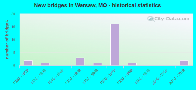
- New bridges - historical statistics
- 21920-1929
- 11930-1939
- 31950-1959
- 11960-1969
- 161970-1979
- 11980-1989
- 22010-2019

- Reconstructed bridges - Historical Statistics
- 11970-1979
- 21980-1989
- 01990-1999
- 12000-2009
- 22010-2019
- 22020-2022


- Bridge Condition - Deck
- 6.7%Excellent
- 20.0%Good
- 46.7%Satisfactory
- 20.0%Fair
- 6.7%Poor

- Bridge Condition - Superstructure
- 6.7%Excellent
- 26.7%Good
- 26.7%Satisfactory
- 33.3%Fair
- 6.7%Poor

- Bridge Condition - Substructure
- 6.7%Excellent
- 13.3%Very good
- 20.0%Good
- 33.3%Satisfactory
- 26.7%Fair

- Bridge Condition - Channel
- 10.0%Excellent
- 20.0%Very good
- 10.0%Good
- 10.0%Satisfactory
- 30.0%Fair
- 20.0%Poor

- Bridge Condition - Culverts
- 66.7%Satisfactory
- 33.3%Fair
Find on map >> Show street view
Structure Number: 18767, Location: S 19 T 41 N R 22 W (Lat: 38.318000, Lng: -93.388722), Route carried "on" structure: County highway 198, Year Built: 1952, Status: Open, Structure Length: 0.79m (2.59ft), Average Daily Traffic: 15 (year 2021), Truck Traffic: 10%, Average Future Daily Traffic: 22 (year 2041), Features Intersected: CRAWFISH HOLLOW, Facility Carried by Structure: DOWNING AVE
Minimum Vertical Clearance: 30+ m (98+ ft), Kilometerpoint: 2.414, Lanes on structure: 1, Owner: County Highway Agency, Approaching Roadway Width: 7.3m (24.0ft), Material/Design: Steel, Design/Construction: Stringer/Multi-beam, Number Of Spans In Main Unit: 1, Length of Maximum Span: 7.6m (24.9ft), Curb-To-Curb Width: 4.3m (14.1ft), Out-to-Out Width: 4.8m (15.7ft)
Condition: Deck: Fair, Superstructure: Satisfactory, Substructure: Fair, Channel: Poor, Operating Rating: 49.5 metric tons, Method Used To Determine Operating Rating: Allowable Stress (AS), Inventory Rating: 22.5 metric tons, Method Used To Determine Inventory Rating: Allowable Stress (AS), Structural Evaluation: Somewhat better than minimum adequacy, Deck Geometry: Equal to present minimum criteria, Waterway Adequacy: Equal to present minimum criteria, Approach Roadway Alignment: Equal to present minimum criteria, Designated Inspection Frequency: Every 24 months, Inspection Date: January 2022, Deck Structure Type: Concrete Cast-file-Place, Wearing Surface/Protective System: Wearing Surface: Monolithic Concrete
Find on map >> Show street view
Structure Number: 19533, Location: S 9 T 40 N R 22 W (Lat: 38.264722, Lng: -93.364333), Route carried "on" structure: County highway 224, Year Built: 1920, Year Reconstructed: 1991, Status: Open, Structure Length: 0.94m (3.08ft), Average Daily Traffic: 200 (year 2021), Truck Traffic: 10%, Average Future Daily Traffic: 290 (year 2041), Features Intersected: TRUSSEL CR, Facility Carried by Structure: LOST VALLEY RD
Minimum Vertical Clearance: 30+ m (98+ ft), Kilometerpoint: 0.483, Lanes on structure: 2, Owner: County Highway Agency, Approaching Roadway Width: 7.0m (23.0ft), Material/Design: Concrete, Design/Construction: Slab, Number Of Spans In Main Unit: 2, Length of Maximum Span: 4.3m (14.1ft), Curb-To-Curb Width: 6.2m (20.3ft), Out-to-Out Width: 6.7m (22.0ft)
Condition: Deck: Satisfactory, Superstructure: Satisfactory, Substructure: Satisfactory, Channel: Fair, Operating Rating: 49.5 metric tons, Method Used To Determine Operating Rating: Allowable Stress (AS), Inventory Rating: 22.5 metric tons, Method Used To Determine Inventory Rating: Allowable Stress (AS), Structural Evaluation: Equal to present minimum criteria, Deck Geometry: Meets minimum limits, Waterway Adequacy: Better than present minimum criteria, Approach Roadway Alignment: Equal to present desirable criteria, Designated Inspection Frequency: Every 24 months, Inspection Date: January 2022, Deck Structure Type: Concrete Cast-file-Place, Wearing Surface/Protective System: Wearing Surface: Bituminous
Find on map >> Show street view
Structure Number: 19553, Location: S 2 T 40 N R 22 W (Lat: 38.280306, Lng: -93.322833), Route carried "on" structure: County highway 224, Year Built: 1920, Year Reconstructed: 1993, Status: Open, Structure Length: 0.94m (3.08ft), Average Daily Traffic: 100 (year 2021), Truck Traffic: 10%, Average Future Daily Traffic: 145 (year 2041), Features Intersected: NEGRO CR, Facility Carried by Structure: LOST VALLEY RD
Minimum Vertical Clearance: 30+ m (98+ ft), Kilometerpoint: 4.023, Lanes on structure: 2, Owner: County Highway Agency, Approaching Roadway Width: 7.3m (24.0ft), Material/Design: Concrete, Design/Construction: Slab, Number Of Spans In Main Unit: 1, Length of Maximum Span: 8.8m (28.9ft), Curb-To-Curb Width: 8.0m (26.2ft), Out-to-Out Width: 8.4m (27.6ft)
Condition: Deck: Satisfactory, Superstructure: Fair, Substructure: Fair, Channel: Poor, Operating Rating: 27.0 metric tons, Method Used To Determine Operating Rating: Allowable Stress (AS), Inventory Rating: 15.3 metric tons, Method Used To Determine Inventory Rating: Allowable Stress (AS), Structural Evaluation: Meets minimum limits, Deck Geometry: Equal to present minimum criteria, Waterway Adequacy: Equal to present minimum criteria, Approach Roadway Alignment: Somewhat better than minimum adequacy, Bridge Posting: Required (Relationship of Operating Rating to Maximum Legal Load: 20.0 - 29.9% below), Designated Inspection Frequency: Every 24 months, Inspection Date: January 2022, Deck Structure Type: Concrete Cast-file-Place, Wearing Surface/Protective System: Wearing Surface: Bituminous
Find on map >> Show street view
Structure Number: 2547, Location: S 16 T 40 N R 22 W (Lat: 38.246789, Lng: -93.383311), Route carried "on" structure: City street , Year Built: 1976, Status: Open, Structure Length: 7.80m (25.59ft), Average Daily Traffic: 868 (year 2021), Truck Traffic: 11%, Average Future Daily Traffic: 1,389 (year 2041), Design Load: H 20, Features Intersected: MO 7, Facility Carried by Structure: JACKSON ST S
Minimum Vertical Clearance: 30+ m (98+ ft), Kilometerpoint: 0.848, Lanes on structure: 2, Lanes under structure: 2, Owner: State Highway Agency, Approaching Roadway Width: 7.3m (24.0ft), Skew: 2 degrees, Material/Design: Steel continuous, Design/Construction: Stringer/Multi-beam, Number Of Spans In Main Unit: 3, Length of Maximum Span: 28.3m (92.8ft), Curb or Sidewalk Widths: Left: 0.0m, Right: 1.4m (4.6ft), Curb-To-Curb Width: 12.2m (40.0ft), Out-to-Out Width: 13.2m (43.3ft)
Condition: Deck: Satisfactory, Superstructure: Good, Substructure: Satisfactory, Operating Rating: 35.1 metric tons, Method Used To Determine Operating Rating: Allowable Stress (AS), Inventory Rating: 22.5 metric tons, Method Used To Determine Inventory Rating: Allowable Stress (AS), Structural Evaluation: Equal to present minimum criteria, Deck Geometry: Equal to present desirable criteria, Underclear: Equal to present desirable criteria, Approach Roadway Alignment: Equal to present desirable criteria, Designated Inspection Frequency: Every 24 months, Inspection Date: October 2020, Deck Structure Type: Concrete Cast-file-Place, Wearing Surface/Protective System: Wearing Surface: Monolithic Concrete
Find on map >> Show street view
Structure Number: 2587, Location: S 17 T 40 N R 22 W (Lat: 38.243358, Lng: -93.387569), Route carried "on" structure: State highway 7, Year Built: 1977, Year Reconstructed: 2017, Status: Open, Structure Length: 25.36m (83.20ft), Average Daily Traffic: 6,209 (year 2021), Truck Traffic: 4%, Average Future Daily Traffic: 10,866 (year 2041), Design Load: HS 20, Features Intersected: OSAGE RVR
Minimum Vertical Clearance: 30+ m (98+ ft), Kilometerpoint: 170.544, Lanes on structure: 2, Base Highway Network: Yes, Owner: State Highway Agency, Approaching Roadway Width: 13.4m (44.0ft), Skew: 1 degrees, Material/Design: Steel continuous, Design/Construction: Stringer/Multi-beam, Number Of Spans In Main Unit: 2, Number Of Approach Spans: 5, Length of Maximum Span: 74.1m (243.1ft), Curb-To-Curb Width: 13.4m (44.0ft), Out-to-Out Width: 14.4m (47.2ft)
Condition: Deck: Satisfactory, Superstructure: Fair, Substructure: Fair, Channel: Very good, Operating Rating: 60.3 metric tons, Method Used To Determine Operating Rating: Load Factor (LF), Inventory Rating: 29.7 metric tons, Method Used To Determine Inventory Rating: Load Factor (LF), Structural Evaluation: Somewhat better than minimum adequacy, Deck Geometry: Equal to present minimum criteria, Waterway Adequacy: Equal to present desirable criteria, Approach Roadway Alignment: Equal to present minimum criteria, Designated Inspection Frequency: Every 24 months, Underwater Inspection Frequency: Every 60 months, Inspection Date: October 2020, Underwater Inspection Date: July 2020, Deck Structure Type: Concrete Cast-file-Place, Wearing Surface/Protective System: Wearing Surface: Latex Concrete
Find on map >> Show street view
Structure Number: 2588, Location: S 9 T 40 N R 22 W (Lat: 38.265106, Lng: -93.368553), Route carried "on" structure: US 65, Year Built: 1977, Status: Open, Structure Length: 4.27m (14.01ft), Average Daily Traffic: 5,039 (year 2021), Truck Traffic: 11%, Average Future Daily Traffic: 8,818 (year 2041), Design Load: HS 20, Features Intersected: CRD TRUMAN DAM ACCESS RD
Minimum Vertical Clearance: 30+ m (98+ ft), Kilometerpoint: 292.442, Lanes on structure: 2, Lanes under structure: 2, Base Highway Network: Yes, Owner: State Highway Agency, Approaching Roadway Width: 13.4m (44.0ft), Material/Design: Prestressed concrete continuous, Design/Construction: Stringer/Multi-beam, Number Of Spans In Main Unit: 3, Length of Maximum Span: 16.8m (55.1ft), Curb-To-Curb Width: 13.4m (44.0ft), Out-to-Out Width: 14.3m (46.9ft)
Condition: Deck: Satisfactory, Superstructure: Good, Substructure: Very good, Operating Rating: 62.1 metric tons, Method Used To Determine Operating Rating: Load Factor (LF), Inventory Rating: 32.4 metric tons, Method Used To Determine Inventory Rating: Load Factor (LF), Structural Evaluation: Better than present minimum criteria, Deck Geometry: Superior to present desirable criteria, Underclear: Equal to present minimum criteria, Approach Roadway Alignment: Equal to present desirable criteria, Designated Inspection Frequency: Every 24 months, Inspection Date: October 2020, Deck Structure Type: Concrete Cast-file-Place, Wearing Surface/Protective System: Wearing Surface: Monolithic Concrete, Deck Protection: Epoxy Coated Reinforcing
Find on map >> Show street view
Structure Number: 2589, Location: S 20 T 26 N R 26 W (Lat: 38.253478, Lng: -93.364269), Route carried "on" structure: State highway 7, Year Built: 1976, Status: Open, Structure Length: 8.17m (26.80ft), Average Daily Traffic: 5,009 (year 2021), Truck Traffic: 13%, Average Future Daily Traffic: 8,766 (year 2041), Design Load: HS 20, Features Intersected: US 65
Minimum Vertical Clearance: 30+ m (98+ ft), Kilometerpoint: 127.417, Lanes on structure: 3, Lanes under structure: 4, Base Highway Network: Yes, Owner: State Highway Agency, Approaching Roadway Width: 14.6m (47.9ft), Skew: 1 degrees, Material/Design: Steel continuous, Design/Construction: Stringer/Multi-beam, Number Of Spans In Main Unit: 3, Number Of Approach Spans: 1, Length of Maximum Span: 27.1m (88.9ft), Curb-To-Curb Width: 18.9m (62.0ft), Out-to-Out Width: 19.8m (65.0ft)
Condition: Deck: Satisfactory, Superstructure: Satisfactory, Substructure: Satisfactory, Operating Rating: 58.5 metric tons, Method Used To Determine Operating Rating: Load Factor (LF), Inventory Rating: 35.1 metric tons, Method Used To Determine Inventory Rating: Load Factor (LF), Structural Evaluation: Equal to present minimum criteria, Deck Geometry: Superior to present desirable criteria, Underclear: Superior to present desirable criteria, Approach Roadway Alignment: Equal to present desirable criteria, Designated Inspection Frequency: Every 24 months, Other Special Inspection Frequency: Every 24 months, Inspection Date: October 2020, Other Special Inspection Date: October 2020, Deck Structure Type: Concrete Cast-file-Place, Wearing Surface/Protective System: Wearing Surface: Monolithic Concrete, Deck Protection: Epoxy Coated Reinforcing
Find on map >> Show street view
Structure Number: 259, Location: S 3 T 49 N R 33 W (Lat: 39.096419, Lng: -94.551542), Route carried "on" structure: City street , Year Built: 1958, Year Reconstructed: 1984, Status: Open, Structure Length: 7.89m (25.89ft), Average Daily Traffic: 8,479 (year 2021), Truck Traffic: 7%, Average Future Daily Traffic: 11,447 (year 2041), Design Load: H 10, Features Intersected: IS 70, Facility Carried by Structure: PROSPECT AVE S
Minimum Vertical Clearance: 30+ m (98+ ft), Kilometerpoint: 1.061, Lanes on structure: 4, Lanes under structure: 7, Owner: State Highway Agency, Approaching Roadway Width: 12.2m (40.0ft), Skew: 2 degrees, Material/Design: Concrete continuous, Design/Construction: Box Beam or Girders - Single/Spread, Number Of Spans In Main Unit: 4, Length of Maximum Span: 22.9m (75.1ft), Curb or Sidewalk Widths: Left: 1.7m (5.6ft), Right: 1.7m (5.6ft), Curb-To-Curb Width: 14.6m (47.9ft), Out-to-Out Width: 18.3m (60.0ft)
Condition: Deck: Poor, Superstructure: Poor, Substructure: Fair, Operating Rating: 55.8 metric tons, Method Used To Determine Operating Rating: Allowable Stress (AS), Inventory Rating: 12.6 metric tons, Method Used To Determine Inventory Rating: Allowable Stress (AS), Structural Evaluation: High priority of replacement, Deck Geometry: High priority of replacement, Underclear: High priority of replacement, Approach Roadway Alignment: Equal to present desirable criteria, Length Of Structure Improvement: 0.89m (2.92ft), Designated Inspection Frequency: Every 24 months, Inspection Date: September 2021, Bridge Improvement Cost: $1,752,000, Roadway Improvement Cost: $175,000, Total Project Cost: $2,628,000 ( Estimate for 2022), Deck Structure Type: Concrete Cast-file-Place, Wearing Surface/Protective System: Wearing Surface: Other
Find on map >> Show street view
Structure Number: 259, Location: S 16 T 40 N R 22 W (Lat: 38.242569, Lng: -93.360328), Route carried "on" structure: City street , Year Built: 1976, Year Reconstructed: 2020, Status: Open, Structure Length: 8.66m (28.41ft), Average Daily Traffic: 1,842 (year 2021), Truck Traffic: 11%, Average Future Daily Traffic: 3,316 (year 2041), Design Load: HS 20, Features Intersected: US 65, Facility Carried by Structure: E MAIN N
Minimum Vertical Clearance: 30+ m (98+ ft), Kilometerpoint: 0.000, Lanes on structure: 2, Lanes under structure: 2, Base Highway Network: Yes, Owner: State Highway Agency, Approaching Roadway Width: 13.4m (44.0ft), Skew: 2 degrees, Material/Design: Steel continuous, Design/Construction: Stringer/Multi-beam, Number Of Spans In Main Unit: 2, Length of Maximum Span: 36.9m (121.1ft), Curb-To-Curb Width: 13.4m (44.0ft), Out-to-Out Width: 14.3m (46.9ft)
Condition: Deck: Good, Superstructure: Good, Substructure: Satisfactory, Operating Rating: 53.1 metric tons, Method Used To Determine Operating Rating: Load Factor (LF), Inventory Rating: 32.4 metric tons, Method Used To Determine Inventory Rating: Load Factor (LF), Structural Evaluation: Equal to present minimum criteria, Deck Geometry: Equal to present desirable criteria, Underclear: Better than present minimum criteria, Approach Roadway Alignment: Equal to present desirable criteria, Designated Inspection Frequency: Every 24 months, Inspection Date: October 2020, Deck Structure Type: Concrete Cast-file-Place, Wearing Surface/Protective System: Wearing Surface: Monolithic Concrete, Deck Protection: Epoxy Coated Reinforcing
Find on map >> Show street view
Structure Number: 2591, Location: S 21 T 40 N R 22 W (Lat: 38.236858, Lng: -93.359811), Route carried "on" structure: US 65, Year Built: 1974, Year Reconstructed: 2009, Status: Open, Structure Length: 31.26m (102.56ft), Average Daily Traffic: 8,998 (year 2021), Truck Traffic: 11%, Average Future Daily Traffic: 15,747 (year 2041), Design Load: HS 20, Features Intersected: OSAGE RVR
Minimum Vertical Clearance: 30+ m (98+ ft), Kilometerpoint: 295.595, Lanes on structure: 3, Base Highway Network: Yes, Owner: State Highway Agency, Approaching Roadway Width: 13.4m (44.0ft), Material/Design: Steel continuous, Design/Construction: Stringer/Multi-beam, Number Of Spans In Main Unit: 9, Length of Maximum Span: 68.6m (225.1ft), Curb-To-Curb Width: 13.4m (44.0ft), Out-to-Out Width: 14.2m (46.6ft)
Condition: Deck: Fair, Superstructure: Fair, Substructure: Satisfactory, Channel: Good, Operating Rating: 47.7 metric tons, Method Used To Determine Operating Rating: Load Factor (LF), Inventory Rating: 28.8 metric tons, Method Used To Determine Inventory Rating: Load Factor (LF), Structural Evaluation: Somewhat better than minimum adequacy, Deck Geometry: Somewhat better than minimum adequacy, Waterway Adequacy: Equal to present desirable criteria, Approach Roadway Alignment: Equal to present desirable criteria, Designated Inspection Frequency: Every 24 months, Underwater Inspection Frequency: Every 60 months, Inspection Date: March 2021, Underwater Inspection Date: July 2020, Deck Structure Type: Concrete Cast-file-Place, Wearing Surface/Protective System: Wearing Surface: Latex Concrete
Find on map >> Show street view
Structure Number: 2592, Location: S 21 T 40 N R 22 W (Lat: 38.231614, Lng: -93.358311), Route carried "on" structure: State highway 83, Year Built: 1976, Year Reconstructed: 2021, Status: Open, Structure Length: 6.61m (21.69ft), Average Daily Traffic: 2,435 (year 2021), Truck Traffic: 22%, Average Future Daily Traffic: 4,383 (year 2041), Design Load: H 20, Features Intersected: US 65
Minimum Vertical Clearance: 30+ m (98+ ft), Kilometerpoint: 0.042, Lanes on structure: 2, Lanes under structure: 2, Base Highway Network: Yes, Owner: State Highway Agency, Approaching Roadway Width: 12.2m (40.0ft), Material/Design: Steel continuous, Design/Construction: Stringer/Multi-beam, Number Of Spans In Main Unit: 2, Length of Maximum Span: 33.1m (108.6ft), Curb-To-Curb Width: 12.2m (40.0ft), Out-to-Out Width: 13.0m (42.7ft)
Condition: Deck: Excellent, Superstructure: Satisfactory, Substructure: Good, Operating Rating: 45.9 metric tons, Method Used To Determine Operating Rating: Load Factor (LF), Inventory Rating: 27.0 metric tons, Method Used To Determine Inventory Rating: Load Factor (LF), Structural Evaluation: Equal to present minimum criteria, Deck Geometry: Equal to present minimum criteria, Underclear: Equal to present desirable criteria, Approach Roadway Alignment: Equal to present desirable criteria, Designated Inspection Frequency: Every 24 months, Inspection Date: November 2021, Deck Structure Type: Concrete Cast-file-Place, Wearing Surface/Protective System: Wearing Surface: Monolithic Concrete, Deck Protection: Epoxy Coated Reinforcing
Find on map >> Show street view
Structure Number: 2593, Location: S 27 T 40 N R 22 W (Lat: 38.220386, Lng: -93.352492), Route carried "on" structure: US 65, Year Built: 1977, Status: Open, Structure Length: 4.54m (14.90ft), Average Daily Traffic: 6,693 (year 2021), Truck Traffic: 11%, Average Future Daily Traffic: 11,713 (year 2041), Design Load: HS 20, Features Intersected: MO 83
Minimum Vertical Clearance: 30+ m (98+ ft), Kilometerpoint: 297.702, Lanes on structure: 2, Lanes under structure: 2, Base Highway Network: Yes, Owner: State Highway Agency, Approaching Roadway Width: 13.4m (44.0ft), Material/Design: Prestressed concrete continuous, Design/Construction: Stringer/Multi-beam, Number Of Spans In Main Unit: 3, Length of Maximum Span: 17.4m (57.1ft), Curb-To-Curb Width: 13.4m (44.0ft), Out-to-Out Width: 14.3m (46.9ft)
Condition: Deck: Satisfactory, Superstructure: Good, Substructure: Very good, Operating Rating: 61.2 metric tons, Method Used To Determine Operating Rating: Load Factor (LF), Inventory Rating: 36.0 metric tons, Method Used To Determine Inventory Rating: Load Factor (LF), Structural Evaluation: Better than present minimum criteria, Deck Geometry: Equal to present minimum criteria, Underclear: Equal to present minimum criteria, Approach Roadway Alignment: Equal to present desirable criteria, Designated Inspection Frequency: Every 24 months, Inspection Date: October 2020, Deck Structure Type: Concrete Cast-file-Place, Wearing Surface/Protective System: Wearing Surface: Monolithic Concrete, Deck Protection: Epoxy Coated Reinforcing
Find on map >> Show street view
Structure Number: 291, Location: S 24 T 40 N R 22 W (Lat: 38.239444, Lng: -93.416328), Route carried "on" structure: State highway 7, Year Built: 1970, Year Reconstructed: 2010, Status: Open, Structure Length: 156.31m (512.83ft), Average Daily Traffic: 6,209 (year 2021), Truck Traffic: 4%, Average Future Daily Traffic: 10,866 (year 2041), Design Load: H 20, Features Intersected: TRUMAN RESERVOIR
Minimum Vertical Clearance: 30+ m (98+ ft), Kilometerpoint: 167.300, Lanes on structure: 2, Base Highway Network: Yes, Owner: State Highway Agency, Approaching Roadway Width: 7.3m (24.0ft), Material/Design: Steel continuous, Design/Construction: Stringer/Multi-beam, Number Of Spans In Main Unit: 30, Length of Maximum Span: 52.7m (172.9ft), Curb-To-Curb Width: 9.8m (32.2ft), Out-to-Out Width: 10.6m (34.8ft)
Condition: Deck: Fair, Superstructure: Fair, Substructure: Good, Channel: Very good, Operating Rating: 50.4 metric tons, Method Used To Determine Operating Rating: Load Factor (LF), Inventory Rating: 30.6 metric tons, Method Used To Determine Inventory Rating: Load Factor (LF), Structural Evaluation: Somewhat better than minimum adequacy, Deck Geometry: Meets minimum limits, Waterway Adequacy: Equal to present desirable criteria, Approach Roadway Alignment: Equal to present desirable criteria, Designated Inspection Frequency: Every 24 months, Underwater Inspection Frequency: Every 60 months, Inspection Date: Febuary 2021, Underwater Inspection Date: July 2020, Deck Structure Type: Concrete Cast-file-Place, Wearing Surface/Protective System: Wearing Surface: Latex Concrete
Find on map >> Show street view
Structure Number: 33131, Location: S 9 T 40 N R 22 W (Lat: 38.264881, Lng: -93.368575), Route carried "on" structure: US 65, Year Built: 2010, Status: Open, Structure Length: 4.69m (15.39ft), Average Daily Traffic: 4,813 (year 2021), Truck Traffic: 11%, Average Future Daily Traffic: 8,423 (year 2041), Features Intersected: CRD TRUMAN DAM ACCESS RD
Minimum Vertical Clearance: 30+ m (98+ ft), Kilometerpoint: 211.333, Lanes on structure: 2, Lanes under structure: 2, Base Highway Network: Yes, Owner: State Highway Agency, Approaching Roadway Width: 11.0m (36.1ft), Material/Design: Prestressed concrete continuous, Design/Construction: Stringer/Multi-beam, Number Of Spans In Main Unit: 3, Length of Maximum Span: 18.3m (60.0ft), Curb-To-Curb Width: 11.3m (37.1ft), Out-to-Out Width: 12.1m (39.7ft)
Condition: Deck: Good, Superstructure: Excellent, Substructure: Excellent, Operating Rating: 71.1 metric tons, Method Used To Determine Operating Rating: Load Factor (LF), Inventory Rating: 43.2 metric tons, Method Used To Determine Inventory Rating: Load Factor (LF), Structural Evaluation: Superior to present desirable criteria, Deck Geometry: Equal to present minimum criteria, Underclear: Meets minimum limits, Approach Roadway Alignment: Equal to present desirable criteria, Designated Inspection Frequency: Every 24 months, Inspection Date: October 2020, Deck Structure Type: Concrete Cast-file-Place, Wearing Surface/Protective System: Wearing Surface: Monolithic Concrete, Deck Protection: Epoxy Coated Reinforcing
Find on map >> Show street view
Structure Number: 6858, Location: S 22 T 40 N R 22 W (Lat: 38.229597, Lng: -93.343844), Route carried "on" structure: State highway MM, Year Built: 1966, Year Reconstructed: 2020, Status: Open, Structure Length: 0.83m (2.72ft), Average Daily Traffic: 1,365 (year 2021), Truck Traffic: 5%, Average Future Daily Traffic: 2,184 (year 2041), Design Load: H 10, Features Intersected: WHITE BR
Minimum Vertical Clearance: 30+ m (98+ ft), Kilometerpoint: 8.695, Lanes on structure: 2, Owner: State Highway Agency, Approaching Roadway Width: 8.5m (27.9ft), Skew: 2 degrees, Material/Design: Concrete continuous, Design/Construction: Culvert, Number Of Spans In Main Unit: 2, Length of Maximum Span: 3.7m (12.1ft), Curb-To-Curb Width: 8.6m (28.2ft), Out-to-Out Width: 9.2m (30.2ft)
Condition: Channel: Satisfactory, Culverts: Satisfactory, Operating Rating: 47.7 metric tons, Method Used To Determine Operating Rating: Load Factor (LF), Inventory Rating: 28.8 metric tons, Method Used To Determine Inventory Rating: Load Factor (LF), Structural Evaluation: Equal to present minimum criteria, Deck Geometry: Somewhat better than minimum adequacy, Waterway Adequacy: Better than present minimum criteria, Approach Roadway Alignment: Somewhat better than minimum adequacy, Designated Inspection Frequency: Every 24 months, Inspection Date: March 2021
Find on map >> Show street view
Structure Number: 6859, Location: S 21 T 41 N R 22 W (Lat: 38.311783, Lng: -93.363672), Route carried "on" structure: State highway T, Year Built: 1958, Status: Open, Structure Length: 0.69m (2.26ft), Average Daily Traffic: 630 (year 2021), Truck Traffic: 13%, Average Future Daily Traffic: 1,008 (year 2041), Design Load: H 10, Features Intersected: STERRETT CR
Minimum Vertical Clearance: 30+ m (98+ ft), Kilometerpoint: 12.870, Lanes on structure: 2, Owner: State Highway Agency, Approaching Roadway Width: 7.3m (24.0ft), Material/Design: Concrete continuous, Design/Construction: Culvert, Number Of Spans In Main Unit: 2, Length of Maximum Span: 3.4m (11.2ft), Curb-To-Curb Width: 7.3m (24.0ft), Out-to-Out Width: 7.9m (25.9ft)
Condition: Channel: Fair, Culverts: Satisfactory, Operating Rating: 39.6 metric tons, Method Used To Determine Operating Rating: Load Factor (LF), Inventory Rating: 23.4 metric tons, Method Used To Determine Inventory Rating: Load Factor (LF), Structural Evaluation: Equal to present minimum criteria, Deck Geometry: Meets minimum limits, Waterway Adequacy: Equal to present minimum criteria, Approach Roadway Alignment: Equal to present desirable criteria, Designated Inspection Frequency: Every 24 months, Inspection Date: March 2021
Find on map >> Show street view
Structure Number: 8588, Location: S 28 T 40 N R 22 W (Lat: 38.214661, Lng: -93.358939), Route carried "on" structure: State highway 83, Year Built: 1931, Status: Open, Structure Length: 1.14m (3.74ft), Average Daily Traffic: 1,490 (year 2021), Truck Traffic: 9%, Average Future Daily Traffic: 2,682 (year 2041), Design Load: H 10, Features Intersected: BLUE CR
Minimum Vertical Clearance: 30+ m (98+ ft), Kilometerpoint: 3.058, Lanes on structure: 2, Base Highway Network: Yes, Owner: State Highway Agency, Approaching Roadway Width: 7.3m (24.0ft), Material/Design: Concrete continuous, Design/Construction: Culvert, Number Of Spans In Main Unit: 3, Length of Maximum Span: 3.7m (12.1ft), Curb-To-Curb Width: 10.1m (33.1ft), Out-to-Out Width: 10.7m (35.1ft)
Condition: Channel: Fair, Culverts: Fair, Operating Rating: 37.8 metric tons, Method Used To Determine Operating Rating: Load Factor (LF), Inventory Rating: 22.5 metric tons, Method Used To Determine Inventory Rating: Load Factor (LF), Structural Evaluation: Somewhat better than minimum adequacy, Deck Geometry: Somewhat better than minimum adequacy, Waterway Adequacy: Equal to present minimum criteria, Approach Roadway Alignment: Somewhat better than minimum adequacy, Designated Inspection Frequency: Every 24 months, Inspection Date: March 2021
Find on map >> Show street view
Structure Number: CEPMRKMO0000005, Location: WARSAW, MO (Lat: 38.263089, Lng: -93.404811), Route carried "on" structure: ServiceCounty highway , Year Built: 1980, Status: Open, Structure Length: 6.09m (19.98ft), Average Daily Traffic: 2,000 (year 2021), Truck Traffic: 10%, Average Future Daily Traffic: 2,500 (year 2040), Design Load: HS 20, Features Intersected: TRUMAN LAKE SPILLWAY, Facility Carried by Structure: Truman Dam Acc Rd
Minimum Vertical Clearance: 30+ m (98+ ft), Kilometerpoint: 0.000, Lanes on structure: 2, Owner: Corps of Engineers (Civil), Approaching Roadway Width: 8.5m (27.9ft), Material/Design: Steel, Design/Construction: Girder and Floorbeam System, Number Of Spans In Main Unit: 4, Length of Maximum Span: 14.6m (47.9ft), Curb or Sidewalk Widths: Left: 0.6m (2.0ft), Right: 1.3m (4.3ft), Curb-To-Curb Width: 8.5m (27.9ft), Out-to-Out Width: 10.9m (35.8ft)
Condition: Deck: Good, Superstructure: Fair, Substructure: Good, Channel: Excellent, Operating Rating: 45.4 metric tons, Method Used To Determine Operating Rating: Load and Resistance Factor Rating (LRFR) rating reported by rating factor(RF) method using HL-93 loadings, Inventory Rating: 35.0 metric tons, Method Used To Determine Inventory Rating: Load and Resistance Factor Rating (LRFR) rating reported by rating factor(RF) method using HL-93 loadings, Structural Evaluation: Somewhat better than minimum adequacy, Deck Geometry: Somewhat better than minimum adequacy, Waterway Adequacy: Superior to present desirable criteria, Approach Roadway Alignment: Equal to present desirable criteria, Length Of Structure Improvement: 11.26m (36.94ft), Designated Inspection Frequency: Every 24 months, Critical Feature Inspection Frequency: Every 24 months, Inspection Date: April 2021, Critical Feature Inspection Date: April 2021, Bridge Improvement Cost: $625,000, Roadway Improvement Cost: $63,000, Total Project Cost: $938,000 ( Estimate for 2021), Deck Structure Type: Concrete Cast-file-Place, Wearing Surface/Protective System: Wearing Surface: Monolithic Concrete
Find on map >> Show street view
Structure Number: 2547, Location: S 16 T 40 N R 22 W (Lat: 38.246789, Lng: -93.383311), Route carried "under" structure: State highway 7, Year Built: 1976, Structure Length: 0. m, Average Daily Traffic: 6,040 (year 2021), Truck Traffic: 11%, Features Intersected: MO 7, Facility Carried by Structure: JACKSON ST S
Minimum Vertical Clearance: 9.14m (29.99ft), Kilometerpoint: 171.218, Lanes on structure: 2, Lanes under structure: 2, Material/Design: Steel continuous, Design/Construction: Stringer/Multi-beam, Length of Maximum Span: 28.3m (92.8ft)
Find on map >> Show street view
Structure Number: 2588, Location: S 9 T 40 N R 22 W (Lat: 38.265106, Lng: -93.368553), Route carried "under" structure: County highway , Year Built: 1977, Structure Length: 0. m, Average Daily Traffic: 7,270 (year 2021), Truck Traffic: 11%, Features Intersected: CRD TRUMAN DAM ACCESS RD, Facility Carried by Structure: US 65 S
Minimum Vertical Clearance: 4.98m (16.34ft), Kilometerpoint: 1.917, Lanes on structure: 2, Lanes under structure: 2, Material/Design: Prestressed concrete continuous, Design/Construction: Stringer/Multi-beam, Length of Maximum Span: 16.8m (55.1ft)
Find on map >> Show street view
Structure Number: 2589, Location: S 20 T 26 N R 26 W (Lat: 38.253478, Lng: -93.364269), Route carried "under" structure: US 65, Year Built: 1976, Structure Length: 0. m, Average Daily Traffic: 5,785 (year 2021), Truck Traffic: 11%, Features Intersected: US 65, Facility Carried by Structure: MO 7 N
Minimum Vertical Clearance: 5.51m (18.08ft), Kilometerpoint: 293.827, Lanes on structure: 3, Lanes under structure: 2, Material/Design: Steel continuous, Design/Construction: Stringer/Multi-beam, Length of Maximum Span: 27.1m (88.9ft)
Find on map >> Show street view
Structure Number: 2589, Location: S 20 T 26 N R 26 W (Lat: 38.253478, Lng: -93.364269), Route carried "under" structure: US 65, Year Built: 1976, Structure Length: 0. m, Average Daily Traffic: 3,869 (year 2021), Truck Traffic: 10%, Features Intersected: US 65, Facility Carried by Structure: MO 7 N
Minimum Vertical Clearance: 5.11m (16.77ft), Kilometerpoint: 210.005, Lanes on structure: 3, Lanes under structure: 2, Material/Design: Steel continuous, Design/Construction: Stringer/Multi-beam, Length of Maximum Span: 27.1m (88.9ft)
Find on map >> Show street view
Structure Number: 259, Location: S 16 T 40 N R 22 W (Lat: 38.242569, Lng: -93.360328), Route carried "under" structure: US 65, Year Built: 1976, Structure Length: 0. m, Average Daily Traffic: 8,737 (year 2021), Truck Traffic: 11%, Features Intersected: US 65, Facility Carried by Structure: E MAIN N
Minimum Vertical Clearance: 5.00m (16.40ft), Kilometerpoint: 295.111, Lanes on structure: 2, Lanes under structure: 2, Material/Design: Steel continuous, Design/Construction: Stringer/Multi-beam, Length of Maximum Span: 36.9m (121.1ft)
Find on map >> Show street view
Structure Number: 2592, Location: S 21 T 40 N R 22 W (Lat: 38.231614, Lng: -93.358311), Route carried "under" structure: US 65, Year Built: 1976, Structure Length: 0. m, Average Daily Traffic: 8,258 (year 2021), Truck Traffic: 11%, Features Intersected: US 65, Facility Carried by Structure: MO 83 S
Minimum Vertical Clearance: 5.26m (17.26ft), Kilometerpoint: 296.348, Lanes on structure: 2, Lanes under structure: 2, Material/Design: Steel continuous, Design/Construction: Stringer/Multi-beam, Length of Maximum Span: 33.1m (108.6ft)
Find on map >> Show street view
Structure Number: 2593, Location: S 27 T 40 N R 22 W (Lat: 38.220386, Lng: -93.352492), Route carried "under" structure: State highway 83, Year Built: 1977, Structure Length: 0. m, Average Daily Traffic: 1,490 (year 2021), Truck Traffic: 9%, Features Intersected: MO 83, Facility Carried by Structure: US 65 S
Minimum Vertical Clearance: 5.84m (19.16ft), Kilometerpoint: 2.150, Lanes on structure: 2, Lanes under structure: 2, Material/Design: Prestressed concrete continuous, Design/Construction: Stringer/Multi-beam, Length of Maximum Span: 17.4m (57.1ft)
Find on map >> Show street view
Structure Number: 33131, Location: S 9 T 40 N R 22 W (Lat: 38.264881, Lng: -93.368575), Route carried "under" structure: County highway , Year Built: 2010, Structure Length: 0. m, Average Daily Traffic: 7,270 (year 2021), Truck Traffic: 11%, Features Intersected: CRD TRUMAN DAM ACCESS RD, Facility Carried by Structure: US 65 N
Minimum Vertical Clearance: 4.60m (15.09ft), Kilometerpoint: 1.917, Lanes on structure: 2, Lanes under structure: 2, Material/Design: Prestressed concrete continuous, Design/Construction: Stringer/Multi-beam, Length of Maximum Span: 18.3m (60.0ft)