Bridge Statistics for Washington, Missouri (MO)
Condition, Traffic, Stress, Structural Evaluation, Project Costs
- National Bridge Inventory (NBI) Statistics
- 32Number of bridges
- 486ft / 148mTotal length
- $1,104,000Total costs
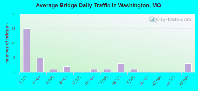
- 203,879Total average daily traffic
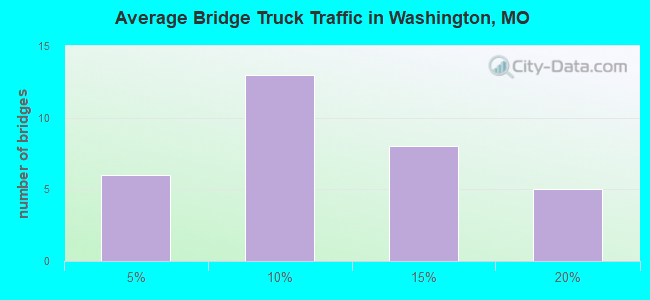
- 19,665Total average daily truck traffic
- 383,801Total future (year 2041) average daily traffic
- National Bridge Inventory (NBI) Registered Bridges for Washington
- No street view available for this location
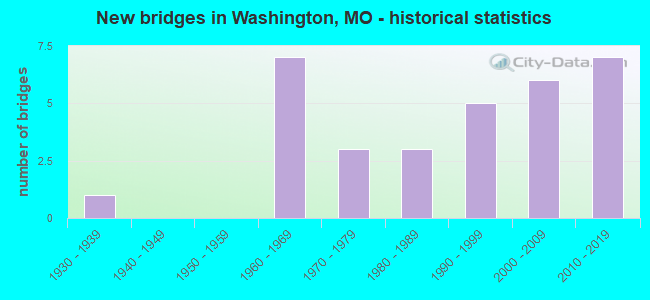
- New bridges - historical statistics
- 11930-1939
- 71960-1969
- 31970-1979
- 31980-1989
- 51990-1999
- 62000-2009
- 72010-2019
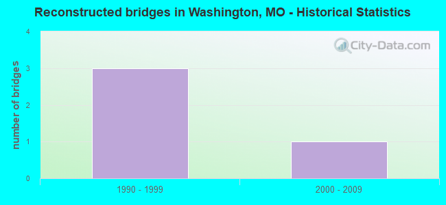
- Reconstructed bridges - Historical Statistics
- 31990-1999
- 12000-2009
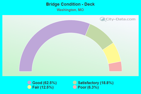
- Bridge Condition - Deck
- 62.5%Good
- 18.8%Satisfactory
- 12.5%Fair
- 6.3%Poor
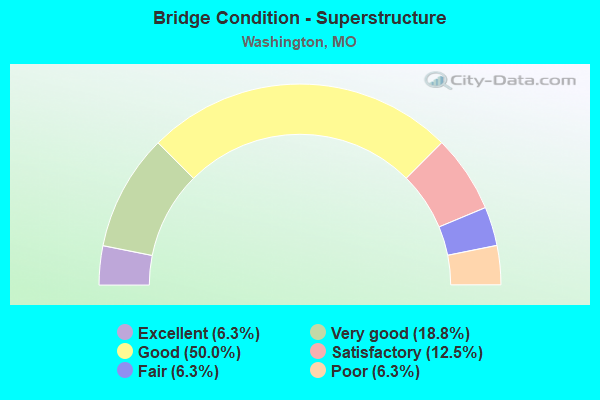
- Bridge Condition - Superstructure
- 6.3%Excellent
- 18.8%Very good
- 50.0%Good
- 12.5%Satisfactory
- 6.3%Fair
- 6.3%Poor
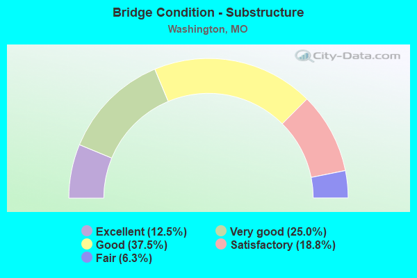
- Bridge Condition - Substructure
- 12.5%Excellent
- 25.0%Very good
- 37.5%Good
- 18.8%Satisfactory
- 6.3%Fair
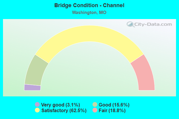
- Bridge Condition - Channel
- 3.1%Very good
- 15.6%Good
- 62.5%Satisfactory
- 18.8%Fair
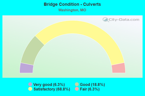
- Bridge Condition - Culverts
- 6.3%Very good
- 18.8%Good
- 68.8%Satisfactory
- 6.3%Fair
Find on map >> Show street view
Structure Number: 14218, Location: S 26 T 44 N R 2 W (Lat: 38.538642, Lng: -91.107803), Route carried "on" structure: County highway 60, Year Built: 1993, Status: Open, Structure Length: 4.05m (13.29ft), Average Daily Traffic: 250 (year 2021), Truck Traffic: 7%, Average Future Daily Traffic: 450 (year 2041), Design Load: HS 20, Features Intersected: ST JOHNS CR, Facility Carried by Structure: FOUR MILE RD
Minimum Vertical Clearance: 30+ m (98+ ft), Kilometerpoint: 1.931, Lanes on structure: 2, Owner: County Highway Agency, Approaching Roadway Width: 5.5m (18.0ft), Material/Design: Prestressed concrete continuous, Design/Construction: Stringer/Multi-beam, Number Of Spans In Main Unit: 3, Length of Maximum Span: 18.3m (60.0ft), Curb-To-Curb Width: 7.4m (24.3ft), Out-to-Out Width: 8.2m (26.9ft)
Condition: Deck: Good, Superstructure: Good, Substructure: Good, Channel: Good, Operating Rating: 54.0 metric tons, Method Used To Determine Operating Rating: Allowable Stress (AS), Inventory Rating: 32.4 metric tons, Method Used To Determine Inventory Rating: Allowable Stress (AS), Structural Evaluation: Better than present minimum criteria, Deck Geometry: Somewhat better than minimum adequacy, Waterway Adequacy: Equal to present minimum criteria, Approach Roadway Alignment: Better than present minimum criteria, Designated Inspection Frequency: Every 24 months, Inspection Date: March 2021, Deck Structure Type: Concrete Cast-file-Place, Wearing Surface/Protective System: Wearing Surface: Monolithic Concrete
Find on map >> Show street view
Structure Number: 15943, Location: S 900 T 43 N R 1 E (Lat: 38.511525, Lng: -90.945678), Route carried "on" structure: County highway , Year Built: 1989, Status: Open, Structure Length: 0.64m (2.10ft), Average Daily Traffic: 250 (year 2021), Truck Traffic: 8%, Average Future Daily Traffic: 450 (year 2041), Features Intersected: BROWNS BR - DUBOIS, Facility Carried by Structure: ST JOHNS RD
Minimum Vertical Clearance: 30+ m (98+ ft), Kilometerpoint: 0.161, Lanes on structure: 2, Owner: County Highway Agency, Approaching Roadway Width: 6.4m (21.0ft), Material/Design: Concrete, Design/Construction: Culvert, Number Of Spans In Main Unit: 2, Length of Maximum Span: 3.0m (9.8ft)
Condition: Channel: Satisfactory, Culverts: Satisfactory, Operating Rating: 49.5 metric tons, Method Used To Determine Operating Rating: Allowable Stress (AS), Inventory Rating: 32.4 metric tons, Method Used To Determine Inventory Rating: Allowable Stress (AS), Structural Evaluation: Equal to present minimum criteria, Waterway Adequacy: Better than present minimum criteria, Approach Roadway Alignment: Equal to present minimum criteria, Designated Inspection Frequency: Every 24 months, Inspection Date: March 2021
Find on map >> Show street view
Structure Number: 15965, Location: S 6 T 43 N R 1 E (Lat: 38.501511, Lng: -90.950972), Route carried "on" structure: County highway 105, Year Built: 1994, Status: Open, Structure Length: 1.86m (6.10ft), Average Daily Traffic: 50 (year 2021), Truck Traffic: 7%, Average Future Daily Traffic: 90 (year 2041), Design Load: HS 20, Features Intersected: BROWNS BR OF DUBOI, Facility Carried by Structure: BUSCH RD
Minimum Vertical Clearance: 30+ m (98+ ft), Kilometerpoint: 0.644, Lanes on structure: 2, Owner: County Highway Agency, Approaching Roadway Width: 6.1m (20.0ft), Material/Design: Prestressed concrete, Design/Construction: Stringer/Multi-beam, Number Of Spans In Main Unit: 1, Length of Maximum Span: 17.7m (58.1ft), Curb-To-Curb Width: 7.5m (24.6ft), Out-to-Out Width: 8.4m (27.6ft)
Condition: Deck: Good, Superstructure: Very good, Substructure: Very good, Channel: Satisfactory, Operating Rating: 54.0 metric tons, Method Used To Determine Operating Rating: Allowable Stress (AS), Inventory Rating: 32.4 metric tons, Method Used To Determine Inventory Rating: Allowable Stress (AS), Structural Evaluation: Equal to present desirable criteria, Deck Geometry: Equal to present minimum criteria, Waterway Adequacy: Equal to present minimum criteria, Approach Roadway Alignment: Somewhat better than minimum adequacy, Designated Inspection Frequency: Every 24 months, Inspection Date: March 2021, Deck Structure Type: Concrete Cast-file-Place, Wearing Surface/Protective System: Wearing Surface: Monolithic Concrete
Find on map >> Show street view
Structure Number: 16514, Location: S 1 T 43 N R 1 W (Lat: 38.514489, Lng: -90.965492), Route carried "on" structure: County highway 123, Year Built: 1976, Status: Posted for load, Structure Length: 1.28m (4.20ft), Average Daily Traffic: 250 (year 2021), Truck Traffic: 10%, Average Future Daily Traffic: 450 (year 2041), Features Intersected: DUBOIS CR, Facility Carried by Structure: N GOODES MILL RD
Minimum Vertical Clearance: 30+ m (98+ ft), Kilometerpoint: 1.127, Lanes on structure: 2, Owner: Local Agency, Approaching Roadway Width: 6.7m (22.0ft), Material/Design: Concrete continuous, Design/Construction: Culvert, Number Of Spans In Main Unit: 3, Length of Maximum Span: 4.3m (14.1ft), Curb-To-Curb Width: 10.7m (35.1ft), Out-to-Out Width: 11.3m (37.1ft)
Condition: Channel: Fair, Culverts: Satisfactory, Operating Rating: 24.3 metric tons, Method Used To Determine Operating Rating: Field evaluation and documented engineering judgment, Inventory Rating: 14.4 metric tons, Method Used To Determine Inventory Rating: Field evaluation and documented engineering judgment, Structural Evaluation: Meets minimum limits, Deck Geometry: Better than present minimum criteria, Waterway Adequacy: Equal to present minimum criteria, Approach Roadway Alignment: Equal to present minimum criteria, Bridge Posting: Required (Relationship of Operating Rating to Maximum Legal Load: 0.1 - 9.9% below), Designated Inspection Frequency: Every 24 months, Inspection Date: March 2021, Deck Structure Type: Concrete Cast-file-Place, Wearing Surface/Protective System: Wearing Surface: Bituminous
Find on map >> Show street view
Structure Number: 16554, Location: S 2 T 43 N R 1 W (Lat: 38.506933, Lng: -90.986050), Route carried "on" structure: County highway 65, Year Built: 1987, Status: Open, Structure Length: 1.01m (3.31ft), Average Daily Traffic: 300 (year 2021), Truck Traffic: 4%, Average Future Daily Traffic: 540 (year 2041), Design Load: HS 15, Features Intersected: DUBOIS CR, Facility Carried by Structure: BIEKER RD
Minimum Vertical Clearance: 30+ m (98+ ft), Kilometerpoint: 1.287, Lanes on structure: 2, Owner: Local Agency, Approaching Roadway Width: 7.3m (24.0ft), Material/Design: Concrete, Design/Construction: Culvert, Number Of Spans In Main Unit: 2, Length of Maximum Span: 4.6m (15.1ft)
Condition: Channel: Satisfactory, Culverts: Satisfactory, Operating Rating: 49.5 metric tons, Method Used To Determine Operating Rating: Allowable Stress (AS), Inventory Rating: 16.2 metric tons, Method Used To Determine Inventory Rating: Allowable Stress (AS), Structural Evaluation: Somewhat better than minimum adequacy, Waterway Adequacy: Better than present minimum criteria, Approach Roadway Alignment: Equal to present desirable criteria, Designated Inspection Frequency: Every 24 months, Inspection Date: March 2021
Find on map >> Show street view
Structure Number: 1784, Location: S 1925 T 44 N R 1 W (Lat: 38.538739, Lng: -90.988525), Route carried "on" structure: State highway 100, Year Built: 1969, Status: Open, Structure Length: 0.81m (2.66ft), Average Daily Traffic: 25,280 (year 2021), Truck Traffic: 9%, Average Future Daily Traffic: 48,032 (year 2041), Design Load: H 20, Features Intersected: MASSEY FK CR
Minimum Vertical Clearance: 30+ m (98+ ft), Kilometerpoint: 114.743, Lanes on structure: 5, Base Highway Network: Yes, Owner: State Highway Agency, Approaching Roadway Width: 21.9m (71.9ft), Skew: 2 degrees, Material/Design: Concrete continuous, Design/Construction: Culvert, Number Of Spans In Main Unit: 2, Length of Maximum Span: 3.7m (12.1ft)
Condition: Channel: Satisfactory, Culverts: Satisfactory, Operating Rating: 65.7 metric tons, Method Used To Determine Operating Rating: Load Factor (LF), Inventory Rating: 39.6 metric tons, Method Used To Determine Inventory Rating: Load Factor (LF), Structural Evaluation: Equal to present minimum criteria, Waterway Adequacy: Equal to present minimum criteria, Approach Roadway Alignment: Equal to present desirable criteria, Designated Inspection Frequency: Every 24 months, Inspection Date: December 2021
Find on map >> Show street view
Structure Number: 1785, Location: S 1925 T 44 N R 1 W (Lat: 38.538331, Lng: -90.984514), Route carried "on" structure: State highway 100, Year Built: 1969, Status: Open, Structure Length: 0.74m (2.43ft), Average Daily Traffic: 25,280 (year 2021), Truck Traffic: 9%, Average Future Daily Traffic: 48,032 (year 2041), Design Load: H 20, Features Intersected: MASSEY CR BR
Minimum Vertical Clearance: 30+ m (98+ ft), Kilometerpoint: 115.096, Lanes on structure: 6, Base Highway Network: Yes, Owner: State Highway Agency, Approaching Roadway Width: 18.3m (60.0ft), Skew: 1 degrees, Material/Design: Concrete continuous, Design/Construction: Culvert, Number Of Spans In Main Unit: 2, Length of Maximum Span: 3.4m (11.2ft)
Condition: Channel: Satisfactory, Culverts: Satisfactory, Structural Evaluation: Equal to present minimum criteria, Waterway Adequacy: Equal to present minimum criteria, Approach Roadway Alignment: Equal to present desirable criteria, Designated Inspection Frequency: Every 24 months, Inspection Date: December 2021
Find on map >> Show street view
Structure Number: 1786, Location: S 404 T 44 N R 1 E (Lat: 38.530019, Lng: -90.959294), Route carried "on" structure: State highway 100, Year Built: 1969, Year Reconstructed: 2008, Status: Open, Structure Length: 5.46m (17.91ft), Average Daily Traffic: 24,789 (year 2021), Truck Traffic: 16%, Average Future Daily Traffic: 52,057 (year 2041), Features Intersected: DUBOIS CR
Minimum Vertical Clearance: 30+ m (98+ ft), Kilometerpoint: 117.466, Lanes on structure: 5, Base Highway Network: Yes, Owner: State Highway Agency, Approaching Roadway Width: 23.2m (76.1ft), Material/Design: Steel continuous, Design/Construction: Stringer/Multi-beam, Number Of Spans In Main Unit: 3, Length of Maximum Span: 20.7m (67.9ft), Curb-To-Curb Width: 24.4m (80.1ft), Out-to-Out Width: 25.2m (82.7ft)
Condition: Deck: Good, Superstructure: Good, Substructure: Satisfactory, Channel: Satisfactory, Operating Rating: 53.1 metric tons, Method Used To Determine Operating Rating: Load Factor (LF), Inventory Rating: 32.4 metric tons, Method Used To Determine Inventory Rating: Load Factor (LF), Structural Evaluation: Equal to present minimum criteria, Deck Geometry: Superior to present desirable criteria, Waterway Adequacy: Equal to present desirable criteria, Approach Roadway Alignment: Equal to present desirable criteria, Designated Inspection Frequency: Every 24 months, Inspection Date: October 2021, Deck Structure Type: Concrete Cast-file-Place, Wearing Surface/Protective System: Wearing Surface: Monolithic Concrete, Deck Protection: Epoxy Coated Reinforcing
Find on map >> Show street view
Structure Number: 23794, Location: S 1923 T 44 N R 1 W (Lat: 38.540431, Lng: -90.973814), Route carried "on" structure: County highway 433, Year Built: 1939, Status: Posted for load, Structure Length: 5.73m (18.80ft), Average Daily Traffic: 1,000 (year 2021), Truck Traffic: 10%, Average Future Daily Traffic: 1,600 (year 2041), Features Intersected: DUBOIS CR, Facility Carried by Structure: OLD HWY 100
Minimum Vertical Clearance: 30+ m (98+ ft), Kilometerpoint: 0.161, Lanes on structure: 2, Owner: County Highway Agency, Approaching Roadway Width: 7.6m (24.9ft), Material/Design: Steel, Design/Construction: Girder and Floorbeam System, Number Of Spans In Main Unit: 3, Length of Maximum Span: 24.1m (79.1ft), Curb-To-Curb Width: 7.9m (25.9ft), Out-to-Out Width: 8.6m (28.2ft)
Condition: Deck: Poor, Superstructure: Poor, Substructure: Fair, Channel: Satisfactory, Operating Rating: 21.6 metric tons, Method Used To Determine Operating Rating: Load Factor (LF), Inventory Rating: 12.6 metric tons, Method Used To Determine Inventory Rating: Load Factor (LF), Structural Evaluation: Meets minimum limits, Deck Geometry: Somewhat better than minimum adequacy, Waterway Adequacy: Equal to present desirable criteria, Approach Roadway Alignment: Equal to present desirable criteria, Bridge Posting: Required (Relationship of Operating Rating to Maximum Legal Load: 30.0 - 39.9% below), Length Of Structure Improvement: 0.68m (2.23ft), Designated Inspection Frequency: Every 24 months, Inspection Date: March 2021, Bridge Improvement Cost: $736,000, Roadway Improvement Cost: $74,000, Total Project Cost: $1,104,000 ( Estimate for 2022), Deck Structure Type: Concrete Cast-file-Place, Wearing Surface/Protective System: Wearing Surface: Bituminous
Find on map >> Show street view
Structure Number: 23964, Location: S 26 T 44 N R 1 W (Lat: 38.536306, Lng: -90.998392), Route carried "on" structure: City street , Year Built: 1988, Status: Open, Structure Length: 0.82m (2.69ft), Average Daily Traffic: 1,000 (year 2021), Truck Traffic: 1%, Average Future Daily Traffic: 1,600 (year 2041), Features Intersected: BR OF BUSCH CR, Facility Carried by Structure: WASHINGTON HTS DR
Minimum Vertical Clearance: 30+ m (98+ ft), Kilometerpoint: 0.805, Lanes on structure: 2, Owner: City or Municipal Highway Agency, Approaching Roadway Width: 11.0m (36.1ft), Skew: 2 degrees, Material/Design: Concrete, Design/Construction: Culvert, Number Of Spans In Main Unit: 2, Length of Maximum Span: 4.0m (13.1ft)
Condition: Channel: Fair, Culverts: Satisfactory, Operating Rating: 49.5 metric tons, Method Used To Determine Operating Rating: Allowable Stress (AS), Inventory Rating: 16.2 metric tons, Method Used To Determine Inventory Rating: Allowable Stress (AS), Structural Evaluation: Meets minimum limits, Waterway Adequacy: Equal to present desirable criteria, Approach Roadway Alignment: Better than present minimum criteria, Designated Inspection Frequency: Every 24 months, Inspection Date: March 2021
Find on map >> Show street view
Structure Number: 23965, Location: S 24 T 44 N R 1 W (Lat: 38.541656, Lng: -90.987358), Route carried "on" structure: City street , Year Built: 1990, Status: Open, Structure Length: 2.04m (6.69ft), Average Daily Traffic: 2,000 (year 2021), Truck Traffic: 2%, Average Future Daily Traffic: 3,200 (year 2041), Design Load: HS 20, Features Intersected: BUSCH CR, Facility Carried by Structure: INTERNATONAL
Minimum Vertical Clearance: 30+ m (98+ ft), Kilometerpoint: 0.966, Lanes on structure: 2, Owner: City or Municipal Highway Agency, Approaching Roadway Width: 10.7m (35.1ft), Material/Design: Concrete, Design/Construction: Culvert, Number Of Spans In Main Unit: 4, Length of Maximum Span: 4.9m (16.1ft)
Condition: Channel: Satisfactory, Culverts: Satisfactory, Operating Rating: 58.5 metric tons, Method Used To Determine Operating Rating: Allowable Stress (AS), Inventory Rating: 32.4 metric tons, Method Used To Determine Inventory Rating: Allowable Stress (AS), Structural Evaluation: Equal to present minimum criteria, Waterway Adequacy: Equal to present desirable criteria, Approach Roadway Alignment: Better than present minimum criteria, Designated Inspection Frequency: Every 24 months, Inspection Date: March 2021
Find on map >> Show street view
Structure Number: 23966, Location: S 26 T 44 N R 1 W (Lat: 38.533508, Lng: -91.004306), Route carried "on" structure: County highway 65, Year Built: 1998, Status: Open, Structure Length: 2.47m (8.10ft), Average Daily Traffic: 800 (year 2021), Truck Traffic: 10%, Average Future Daily Traffic: 1,280 (year 2041), Design Load: HS 20, Features Intersected: BUSCH CR, Facility Carried by Structure: BIEKER RD
Minimum Vertical Clearance: 30+ m (98+ ft), Kilometerpoint: 1.127, Lanes on structure: 2, Owner: City or Municipal Highway Agency, Approaching Roadway Width: 12.2m (40.0ft), Material/Design: Concrete, Design/Construction: Culvert, Number Of Spans In Main Unit: 2, Length of Maximum Span: 19.5m (64.0ft)
Condition: Channel: Fair, Culverts: Fair, Operating Rating: 75.6 metric tons, Method Used To Determine Operating Rating: Load Factor (LF), Inventory Rating: 45.0 metric tons, Method Used To Determine Inventory Rating: Load Factor (LF), Structural Evaluation: Somewhat better than minimum adequacy, Waterway Adequacy: Better than present minimum criteria, Approach Roadway Alignment: Equal to present minimum criteria, Designated Inspection Frequency: Every 24 months, Inspection Date: March 2021
Find on map >> Show street view
Structure Number: 23967, Location: S 1923 T 44 N R 1 E (Lat: 38.540942, Lng: -90.977397), Route carried "on" structure: City street , Year Built: 1979, Status: Posted for load, Structure Length: 2.93m (9.61ft), Average Daily Traffic: 5,000 (year 2021), Truck Traffic: 10%, Average Future Daily Traffic: 8,000 (year 2041), Design Load: H 20, Features Intersected: BUSCH CR, Facility Carried by Structure: E 5TH ST
Minimum Vertical Clearance: 30+ m (98+ ft), Kilometerpoint: 0.000, Lanes on structure: 2, Owner: City or Municipal Highway Agency, Approaching Roadway Width: 13.1m (43.0ft), Material/Design: Prestressed concrete, Design/Construction: Stringer/Multi-beam, Number Of Spans In Main Unit: 3, Length of Maximum Span: 9.8m (32.2ft), Curb-To-Curb Width: 15.2m (49.9ft), Out-to-Out Width: 16.1m (52.8ft)
Condition: Deck: Satisfactory, Superstructure: Very good, Substructure: Satisfactory, Channel: Satisfactory, Operating Rating: 41.4 metric tons, Method Used To Determine Operating Rating: Allowable Stress (AS), Inventory Rating: 27.9 metric tons, Method Used To Determine Inventory Rating: Allowable Stress (AS), Structural Evaluation: Equal to present minimum criteria, Deck Geometry: Superior to present desirable criteria, Waterway Adequacy: Equal to present minimum criteria, Approach Roadway Alignment: Equal to present desirable criteria, Designated Inspection Frequency: Every 24 months, Inspection Date: March 2021, Deck Structure Type: Concrete Cast-file-Place, Wearing Surface/Protective System: Wearing Surface: Monolithic Concrete
Find on map >> Show street view
Structure Number: 28191, Location: S 22 T 44 N R 1 W (Lat: 38.548936, Lng: -91.019411), Route carried "on" structure: City street , Year Built: 1996, Status: Open, Structure Length: 0.91m (2.99ft), Average Daily Traffic: 2,107 (year 2021), Truck Traffic: 5%, Average Future Daily Traffic: 3,371 (year 2041), Design Load: HS 20, Features Intersected: BUSCH CR, Facility Carried by Structure: STAFFORD ST
Minimum Vertical Clearance: 30+ m (98+ ft), Kilometerpoint: 0.161, Lanes on structure: 2, Owner: City or Municipal Highway Agency, Approaching Roadway Width: 12.2m (40.0ft), Material/Design: Concrete, Design/Construction: Culvert, Number Of Spans In Main Unit: 3, Length of Maximum Span: 2.7m (8.9ft), Curb-To-Curb Width: 12.2m (40.0ft), Out-to-Out Width: 14.0m (45.9ft)
Condition: Channel: Satisfactory, Culverts: Good, Operating Rating: 34.2 metric tons, Method Used To Determine Operating Rating: Load Factor (LF), Inventory Rating: 18.0 metric tons, Method Used To Determine Inventory Rating: Load Factor (LF), Structural Evaluation: Somewhat better than minimum adequacy, Deck Geometry: Equal to present minimum criteria, Waterway Adequacy: Equal to present desirable criteria, Approach Roadway Alignment: Equal to present desirable criteria, Designated Inspection Frequency: Every 24 months, Inspection Date: March 2021, Deck Structure Type: Concrete Cast-file-Place
Find on map >> Show street view
Structure Number: 29731, Location: S 22 T 44 N R 1 W (Lat: 38.552417, Lng: -91.011764), Route carried "on" structure: City street , Year Built: 2003, Status: Open, Structure Length: 0.98m (3.22ft), Average Daily Traffic: 1,250 (year 2021), Truck Traffic: 1%, Average Future Daily Traffic: 2,000 (year 2041), Design Load: HS 20, Features Intersected: BUSCH CR, Facility Carried by Structure: LOCUST ST
Minimum Vertical Clearance: 30+ m (98+ ft), Kilometerpoint: 0.161, Lanes on structure: 2, Owner: City or Municipal Highway Agency, Approaching Roadway Width: 9.1m (29.9ft), Skew: 1 degrees, Material/Design: Concrete continuous, Design/Construction: Culvert, Number Of Spans In Main Unit: 2, Length of Maximum Span: 4.4m (14.4ft), Curb-To-Curb Width: 9.1m (29.9ft), Out-to-Out Width: 11.9m (39.0ft)
Condition: Channel: Satisfactory, Culverts: Good, Operating Rating: 57.6 metric tons, Method Used To Determine Operating Rating: Load Factor (LF), Inventory Rating: 34.2 metric tons, Method Used To Determine Inventory Rating: Load Factor (LF), Structural Evaluation: Better than present minimum criteria, Deck Geometry: Somewhat better than minimum adequacy, Waterway Adequacy: Equal to present desirable criteria, Approach Roadway Alignment: Equal to present desirable criteria, Designated Inspection Frequency: Every 24 months, Inspection Date: March 2021, Deck Structure Type: Concrete Cast-file-Place
Find on map >> Show street view
Structure Number: 3086, Location: S 30 T 25 N R 7 E (Lat: 36.790761, Lng: -90.243825), Route carried "on" structure: US 60, Year Built: 1978, Year Reconstructed: 1996, Status: Open, Structure Length: 0.70m (2.30ft), Average Daily Traffic: 6,967 (year 2021), Truck Traffic: 19%, Average Future Daily Traffic: 12,192 (year 2041), Design Load: HS 20, Features Intersected: DRAIN DTCH NO 16
Minimum Vertical Clearance: 30+ m (98+ ft), Kilometerpoint: 104.157, Lanes on structure: 2, Base Highway Network: Yes, Owner: State Highway Agency, Approaching Roadway Width: 12.2m (40.0ft), Material/Design: Concrete continuous, Design/Construction: Culvert, Number Of Spans In Main Unit: 2, Length of Maximum Span: 3.4m (11.2ft)
Condition: Channel: Good, Culverts: Satisfactory, Operating Rating: 85.5 metric tons, Method Used To Determine Operating Rating: Load Factor (LF), Inventory Rating: 51.3 metric tons, Method Used To Determine Inventory Rating: Load Factor (LF), Structural Evaluation: Equal to present minimum criteria, Waterway Adequacy: Equal to present desirable criteria, Approach Roadway Alignment: Equal to present desirable criteria, Designated Inspection Frequency: Every 24 months, Inspection Date: December 2020
Find on map >> Show street view
Structure Number: 3086, Location: S 22 T 44 N R 1 W (Lat: 38.549925, Lng: -91.009236), Route carried "on" structure: City street , Year Built: 2004, Status: Open, Structure Length: 2.36m (7.74ft), Average Daily Traffic: 1,500 (year 2021), Truck Traffic: 5%, Average Future Daily Traffic: 2,400 (year 2041), Design Load: HS 20, Features Intersected: BUSCH CR, Facility Carried by Structure: SUNNYSIDE DR
Minimum Vertical Clearance: 30+ m (98+ ft), Kilometerpoint: 0.322, Lanes on structure: 2, Owner: City or Municipal Highway Agency, Approaching Roadway Width: 10.7m (35.1ft), Material/Design: Prestressed concrete, Design/Construction: Box Beam or Girders - Multiple, Number Of Spans In Main Unit: 1, Length of Maximum Span: 22.9m (75.1ft), Curb-To-Curb Width: 10.8m (35.4ft), Out-to-Out Width: 14.6m (47.9ft)
Condition: Deck: Fair, Superstructure: Fair, Substructure: Good, Channel: Good, Structural Evaluation: Somewhat better than minimum adequacy, Deck Geometry: Equal to present minimum criteria, Waterway Adequacy: Superior to present desirable criteria, Approach Roadway Alignment: Equal to present desirable criteria, Designated Inspection Frequency: Every 24 months, Inspection Date: March 2021, Deck Structure Type: Concrete Precast Panels, Wearing Surface/Protective System: Wearing Surface: Bituminous, Membrane: Preformed Fabric
Find on map >> Show street view
Structure Number: 30986, Location: S 23 T 44 N R 1 W (Lat: 38.548522, Lng: -91.002650), Route carried "on" structure: City street 4465, Year Built: 2003, Status: Open, Structure Length: 1.98m (6.50ft), Average Daily Traffic: 3,000 (year 2021), Truck Traffic: 1%, Average Future Daily Traffic: 4,800 (year 2041), Design Load: HS 20, Features Intersected: BUSCH CR, Facility Carried by Structure: MADISON ST
Minimum Vertical Clearance: 30+ m (98+ ft), Kilometerpoint: 0.644, Lanes on structure: 2, Owner: City or Municipal Highway Agency, Approaching Roadway Width: 10.7m (35.1ft), Material/Design: Prestressed concrete, Design/Construction: Box Beam or Girders - Multiple, Number Of Spans In Main Unit: 1, Length of Maximum Span: 19.0m (62.3ft), Curb or Sidewalk Widths: Left: 1.5m (4.9ft), Right: 1.5m (4.9ft), Curb-To-Curb Width: 10.8m (35.4ft), Out-to-Out Width: 14.6m (47.9ft)
Condition: Deck: Satisfactory, Superstructure: Satisfactory, Substructure: Good, Channel: Satisfactory, Operating Rating: 69.3 metric tons, Method Used To Determine Operating Rating: Load Factor (LF), Inventory Rating: 41.4 metric tons, Method Used To Determine Inventory Rating: Load Factor (LF), Structural Evaluation: Equal to present minimum criteria, Deck Geometry: Somewhat better than minimum adequacy, Waterway Adequacy: Superior to present desirable criteria, Approach Roadway Alignment: Equal to present desirable criteria, Designated Inspection Frequency: Every 24 months, Inspection Date: March 2021, Deck Structure Type: Concrete Precast Panels, Wearing Surface/Protective System: Wearing Surface: Bituminous, Membrane: Preformed Fabric
Find on map >> Show street view
Structure Number: 32098, Location: S 26 T 44 N R 2 W (Lat: 38.531081, Lng: -91.112456), Route carried "on" structure: County highway , Year Built: 2005, Status: Open, Structure Length: 2.01m (6.59ft), Average Daily Traffic: 50 (year 2021), Truck Traffic: 10%, Average Future Daily Traffic: 90 (year 2041), Design Load: HS 20, Features Intersected: LONG BR CR, Facility Carried by Structure: ST JOHN'S CR RD
Minimum Vertical Clearance: 30+ m (98+ ft), Kilometerpoint: 0.966, Lanes on structure: 2, Owner: County Highway Agency, Approaching Roadway Width: 7.3m (24.0ft), Skew: 3 degrees, Material/Design: Prestressed concrete, Design/Construction: Stringer/Multi-beam, Number Of Spans In Main Unit: 1, Length of Maximum Span: 19.2m (63.0ft), Curb-To-Curb Width: 7.3m (24.0ft), Out-to-Out Width: 8.1m (26.6ft)
Condition: Deck: Good, Superstructure: Good, Substructure: Excellent, Channel: Satisfactory, Operating Rating: 70.2 metric tons, Method Used To Determine Operating Rating: Load Factor (LF), Inventory Rating: 41.4 metric tons, Method Used To Determine Inventory Rating: Load Factor (LF), Structural Evaluation: Better than present minimum criteria, Deck Geometry: Equal to present minimum criteria, Waterway Adequacy: Superior to present desirable criteria, Approach Roadway Alignment: Equal to present desirable criteria, Designated Inspection Frequency: Every 24 months, Inspection Date: March 2021, Deck Structure Type: Concrete Cast-file-Place, Wearing Surface/Protective System: Deck Protection: Epoxy Coated Reinforcing
Find on map >> Show street view
Structure Number: 32272, Location: S 3 T 44 N R 2 W (Lat: 38.590181, Lng: -91.123672), Route carried "on" structure: State highway 100, Year Built: 2008, Status: Open, Structure Length: 4.33m (14.21ft), Average Daily Traffic: 7,580 (year 2021), Truck Traffic: 16%, Average Future Daily Traffic: 14,402 (year 2041), Features Intersected: LIT BOEUF CR
Minimum Vertical Clearance: 30+ m (98+ ft), Kilometerpoint: 101.033, Lanes on structure: 2, Base Highway Network: Yes, Owner: State Highway Agency, Approaching Roadway Width: 9.8m (32.2ft), Skew: 1 degrees, Material/Design: Prestressed concrete continuous, Design/Construction: Stringer/Multi-beam, Number Of Spans In Main Unit: 3, Length of Maximum Span: 16.5m (54.1ft), Curb-To-Curb Width: 9.8m (32.2ft), Out-to-Out Width: 10.6m (34.8ft)
Condition: Deck: Satisfactory, Superstructure: Good, Substructure: Very good, Channel: Satisfactory, Operating Rating: 67.5 metric tons, Method Used To Determine Operating Rating: Load Factor (LF), Inventory Rating: 36.9 metric tons, Method Used To Determine Inventory Rating: Load Factor (LF), Structural Evaluation: Better than present minimum criteria, Deck Geometry: Meets minimum limits, Waterway Adequacy: Superior to present desirable criteria, Approach Roadway Alignment: Equal to present minimum criteria, Designated Inspection Frequency: Every 24 months, Inspection Date: October 2021, Deck Structure Type: Concrete Cast-file-Place, Wearing Surface/Protective System: Wearing Surface: Epoxy Overlay, Deck Protection: Epoxy Coated Reinforcing
Find on map >> Show street view
Structure Number: 32686, Location: S 16 T 44 N R 1 W (Lat: 38.569997, Lng: -91.038083), Route carried "on" structure: City street , Year Built: 2009, Status: Open, Structure Length: 5.85m (19.19ft), Average Daily Traffic: 2,500 (year 2021), Truck Traffic: 15%, Average Future Daily Traffic: 4,000 (year 2041), Design Load: HS 20, Features Intersected: ST JOHN'S CR, Facility Carried by Structure: WESTLINK INDUSTRL
Minimum Vertical Clearance: 30+ m (98+ ft), Kilometerpoint: 0.483, Lanes on structure: 2, Owner: City or Municipal Highway Agency, Approaching Roadway Width: 8.5m (27.9ft), Material/Design: Prestressed concrete continuous, Design/Construction: Stringer/Multi-beam, Number Of Spans In Main Unit: 3, Length of Maximum Span: 21.3m (69.9ft), Curb-To-Curb Width: 8.5m (27.9ft), Out-to-Out Width: 11.4m (37.4ft)
Condition: Deck: Good, Superstructure: Very good, Substructure: Good, Channel: Satisfactory, Inventory Rating: 86.4 metric tons, Method Used To Determine Inventory Rating: Load Factor (LF), Structural Evaluation: Better than present minimum criteria, Deck Geometry: Meets minimum limits, Waterway Adequacy: Superior to present desirable criteria, Approach Roadway Alignment: Better than present minimum criteria, Designated Inspection Frequency: Every 24 months, Inspection Date: March 2021, Deck Structure Type: Concrete Precast Panels, Wearing Surface/Protective System: Wearing Surface: Monolithic Concrete, Deck Protection: Epoxy Coated Reinforcing
Find on map >> Show street view
Structure Number: 33296, Location: S 34 T 44 N R 1 W (Lat: 38.516394, Lng: -91.016792), Route carried "on" structure: County highway , Year Built: 2012, Status: Open, Structure Length: 2.07m (6.79ft), Average Daily Traffic: 500 (year 2021), Truck Traffic: 5%, Average Future Daily Traffic: 900 (year 2041), Features Intersected: TRIB TO BUSCH CR, Facility Carried by Structure: COUNTRY CLUB RD
Minimum Vertical Clearance: 30+ m (98+ ft), Kilometerpoint: 1.204, Lanes on structure: 2, Owner: County Highway Agency, Approaching Roadway Width: 8.5m (27.9ft), Skew: 1 degrees, Material/Design: Prestressed concrete, Design/Construction: Stringer/Multi-beam, Number Of Spans In Main Unit: 1, Length of Maximum Span: 19.8m (65.0ft), Curb-To-Curb Width: 8.5m (27.9ft), Out-to-Out Width: 9.5m (31.2ft)
Condition: Deck: Good, Superstructure: Excellent, Substructure: Excellent, Channel: Good, Operating Rating: 67.5 metric tons, Method Used To Determine Operating Rating: Load Factor (LF), Inventory Rating: 40.5 metric tons, Method Used To Determine Inventory Rating: Load Factor (LF), Structural Evaluation: Superior to present desirable criteria, Deck Geometry: Somewhat better than minimum adequacy, Waterway Adequacy: Superior to present desirable criteria, Approach Roadway Alignment: Equal to present desirable criteria, Designated Inspection Frequency: Every 24 months, Inspection Date: March 2021, Deck Structure Type: Concrete Precast Panels, Wearing Surface/Protective System: Wearing Surface: Monolithic Concrete, Deck Protection: Epoxy Coated Reinforcing
Find on map >> Show street view
Structure Number: 34398, Location: S 22 T 44 N R 1 W (Lat: 38.545389, Lng: -91.020528), Route carried "on" structure: City street , Year Built: 2012, Status: Open, Structure Length: 3.44m (11.29ft), Average Daily Traffic: 1,000 (year 2021), Truck Traffic: 2%, Average Future Daily Traffic: 1,600 (year 2041), Design Load: HS 20, Features Intersected: BUSCH CR, Facility Carried by Structure: 14TH ST
Minimum Vertical Clearance: 30+ m (98+ ft), Kilometerpoint: 0.000, Lanes on structure: 2, Owner: City or Municipal Highway Agency, Approaching Roadway Width: 8.8m (28.9ft), Material/Design: Prestressed concrete, Design/Construction: Tee Beam, Number Of Spans In Main Unit: 1, Length of Maximum Span: 32.6m (107.0ft), Curb-To-Curb Width: 8.5m (27.9ft), Out-to-Out Width: 11.4m (37.4ft)
Condition: Deck: Good, Superstructure: Good, Substructure: Very good, Channel: Satisfactory, Operating Rating: 75.6 metric tons, Method Used To Determine Operating Rating: Load Factor (LF), Inventory Rating: 45.0 metric tons, Method Used To Determine Inventory Rating: Load Factor (LF), Structural Evaluation: Better than present minimum criteria, Deck Geometry: Somewhat better than minimum adequacy, Waterway Adequacy: Superior to present desirable criteria, Approach Roadway Alignment: Equal to present desirable criteria, Designated Inspection Frequency: Every 24 months, Inspection Date: March 2021, Deck Structure Type: Concrete Cast-file-Place, Wearing Surface/Protective System: Deck Protection: Epoxy Coated Reinforcing
Find on map >> Show street view
Structure Number: 35061, Location: S 26 T 44 N R 1 W (Lat: 38.543889, Lng: -90.996111), Route carried "on" structure: City street , Year Built: 2015, Status: Open, Structure Length: 3.46m (11.35ft), Average Daily Traffic: 3,000 (year 2021), Truck Traffic: 5%, Average Future Daily Traffic: 4,800 (year 2041), Features Intersected: BUSCH CR, Facility Carried by Structure: CAMP STREET
Minimum Vertical Clearance: 30+ m (98+ ft), Kilometerpoint: 0.000, Lanes on structure: 2, Owner: City or Municipal Highway Agency, Approaching Roadway Width: 10.4m (34.1ft), Material/Design: Prestressed concrete, Design/Construction: Tee Beam, Number Of Spans In Main Unit: 1, Length of Maximum Span: 32.9m (107.9ft), Curb or Sidewalk Widths: Left: 0.0m, Right: 1.3m (4.3ft), Curb-To-Curb Width: 10.4m (34.1ft), Out-to-Out Width: 12.8m (42.0ft)
Condition: Deck: Good, Superstructure: Good, Substructure: Good, Channel: Fair, Operating Rating: 54.0 metric tons, Method Used To Determine Operating Rating: Load Factor (LF), Inventory Rating: 32.4 metric tons, Method Used To Determine Inventory Rating: Load Factor (LF), Structural Evaluation: Better than present minimum criteria, Deck Geometry: Somewhat better than minimum adequacy, Waterway Adequacy: Equal to present desirable criteria, Approach Roadway Alignment: Equal to present desirable criteria, Designated Inspection Frequency: Every 24 months, Inspection Date: March 2021, Deck Structure Type: Concrete Cast-file-Place, Wearing Surface/Protective System: Wearing Surface: Low Slump Concrete, Membrane: Built-up, Deck Protection: Galvanized Reinforcing
Find on map >> Show street view
Structure Number: 35137, Location: S 22 T 44 N R 1 W (Lat: 38.552869, Lng: -91.014000), Route carried "on" structure: City street , Year Built: 2016, Status: Open, Structure Length: 1.31m (4.30ft), Average Daily Traffic: 15,000 (year 2021), Truck Traffic: 5%, Average Future Daily Traffic: 24,000 (year 2041), Features Intersected: BUSCH CR, Facility Carried by Structure: JEFFERSON ST
Minimum Vertical Clearance: 30+ m (98+ ft), Kilometerpoint: 0.805, Lanes on structure: 3, Owner: City or Municipal Highway Agency, Approaching Roadway Width: 14.6m (47.9ft), Skew: 2 degrees, Material/Design: Concrete, Design/Construction: Slab, Number Of Spans In Main Unit: 1, Length of Maximum Span: 12.5m (41.0ft), Curb or Sidewalk Widths: Left: 1.6m (5.2ft), Right: 1.6m (5.2ft), Curb-To-Curb Width: 14.6m (47.9ft), Out-to-Out Width: 18.4m (60.4ft)
Condition: Deck: Good, Superstructure: Good, Substructure: Good, Channel: Good, Operating Rating: 90.0 metric tons, Method Used To Determine Operating Rating: Load Factor (LF), Inventory Rating: 69.3 metric tons, Method Used To Determine Inventory Rating: Load Factor (LF), Structural Evaluation: Better than present minimum criteria, Deck Geometry: Somewhat better than minimum adequacy, Waterway Adequacy: Superior to present desirable criteria, Approach Roadway Alignment: Equal to present desirable criteria, Designated Inspection Frequency: Every 24 months, Inspection Date: March 2021, Deck Structure Type: Concrete Cast-file-Place, Wearing Surface/Protective System: Deck Protection: Epoxy Coated Reinforcing
Find on map >> Show street view
Structure Number: 35231, Location: S 4 T 43 N R 1 W (Lat: 38.500525, Lng: -91.026986), Route carried "on" structure: County highway 125, Year Built: 2015, Status: Posted for load, Structure Length: 1.10m (3.61ft), Average Daily Traffic: 250 (year 2021), Truck Traffic: 5%, Average Future Daily Traffic: 450 (year 2041), Design Load: HS 20, Features Intersected: BR OF BUSCH CREEK, Facility Carried by Structure: COUNTRY CLUB RD
Minimum Vertical Clearance: 30+ m (98+ ft), Kilometerpoint: 4.345, Lanes on structure: 2, Owner: County Highway Agency, Approaching Roadway Width: 6.4m (21.0ft), Material/Design: Steel, Design/Construction: Culvert, Number Of Spans In Main Unit: 4, Length of Maximum Span: 2.4m (7.9ft)
Condition: Channel: Satisfactory, Culverts: Good, Operating Rating: 54.0 metric tons, Method Used To Determine Operating Rating: Load Factor (LF), Inventory Rating: 32.4 metric tons, Method Used To Determine Inventory Rating: Load Factor (LF), Structural Evaluation: Better than present minimum criteria, Waterway Adequacy: Equal to present minimum criteria, Approach Roadway Alignment: Equal to present desirable criteria, Designated Inspection Frequency: Every 24 months, Inspection Date: March 2021
Find on map >> Show street view
Structure Number: 35274, Location: S 23 T 44 N R 1 W (Lat: 38.557914, Lng: -90.998136), Route carried "on" structure: State highway 47, Year Built: 2017, Status: Open, Structure Length: 78.03m (256.00ft), Average Daily Traffic: 13,963 (year 2021), Truck Traffic: 10%, Average Future Daily Traffic: 27,926 (year 2041), Features Intersected: MISSOURI RVR, UP RR
Minimum Vertical Clearance: 30+ m (98+ ft), Kilometerpoint: 90.259, Lanes on structure: 2, Base Highway Network: Yes, Owner: State Highway Agency, Approaching Roadway Width: 13.4m (44.0ft), Navigation Control: Yes ( Vertical Clearance: 15.8m (51.8ft), Horizontal Clearance: 141.1m (462.9ft)), Material/Design: Steel continuous, Design/Construction: Stringer/Multi-beam, Number Of Spans In Main Unit: 4, Number Of Approach Spans: 5, Length of Maximum Span: 152.4m (500.0ft), Curb-To-Curb Width: 13.4m (44.0ft), Out-to-Out Width: 17.6m (57.7ft)
Condition: Deck: Good, Superstructure: Good, Substructure: Very good, Channel: Very good, Operating Rating: 62.1 metric tons, Method Used To Determine Operating Rating: Load Factor (LF), Inventory Rating: 25.2 metric tons, Method Used To Determine Inventory Rating: Load Factor (LF), Structural Evaluation: Equal to present minimum criteria, Deck Geometry: Equal to present minimum criteria, Underclear: Superior to present desirable criteria, Waterway Adequacy: Superior to present desirable criteria, Approach Roadway Alignment: Equal to present desirable criteria, Designated Inspection Frequency: Every 24 months, Underwater Inspection Frequency: Every 60 months, Inspection Date: September 2021, Underwater Inspection Date: October 2019, Deck Structure Type: Concrete Cast-file-Place, Wearing Surface/Protective System: Wearing Surface: Monolithic Concrete, Deck Protection: Epoxy Coated Reinforcing
Find on map >> Show street view
Structure Number: 35523, Location: S 15 T 44 N R 2 W (Lat: 38.573556, Lng: -91.127417), Route carried "on" structure: County highway 52, Year Built: 2016, Status: Open, Structure Length: 0.76m (2.49ft), Average Daily Traffic: 150 (year 2021), Truck Traffic: 15%, Average Future Daily Traffic: 270 (year 2041), Design Load: HS 20, Features Intersected: LIT BOEUF CR, Facility Carried by Structure: BRAMEL RD
Minimum Vertical Clearance: 30+ m (98+ ft), Kilometerpoint: 0.483, Lanes on structure: 2, Owner: County Highway Agency, Approaching Roadway Width: 7.6m (24.9ft), Skew: 1 degrees, Material/Design: Steel, Design/Construction: Culvert, Number Of Spans In Main Unit: 2, Length of Maximum Span: 3.1m (10.2ft)
Condition: Channel: Fair, Culverts: Very good, Operating Rating: 54.0 metric tons, Method Used To Determine Operating Rating: Field evaluation and documented engineering judgment, Inventory Rating: 32.4 metric tons, Method Used To Determine Inventory Rating: Field evaluation and documented engineering judgment, Structural Evaluation: Equal to present desirable criteria, Waterway Adequacy: Better than present minimum criteria, Approach Roadway Alignment: Equal to present desirable criteria, Designated Inspection Frequency: Every 24 months, Inspection Date: March 2021
Find on map >> Show street view
Structure Number: 368, Location: S 22 T 44 N R 1 W (Lat: 38.549297, Lng: -91.004889), Route carried "on" structure: State highway 47, Year Built: 1961, Year Reconstructed: 1998, Status: Open, Structure Length: 0.77m (2.53ft), Average Daily Traffic: 14,268 (year 2021), Truck Traffic: 11%, Average Future Daily Traffic: 27,109 (year 2041), Design Load: HS 20, Features Intersected: BUSCH CR
Minimum Vertical Clearance: 30+ m (98+ ft), Kilometerpoint: 91.800, Lanes on structure: 5, Owner: State Highway Agency, Approaching Roadway Width: 25.0m (82.0ft), Skew: 2 degrees, Material/Design: Concrete continuous, Design/Construction: Culvert, Number Of Spans In Main Unit: 2, Length of Maximum Span: 3.4m (11.2ft)
Condition: Channel: Satisfactory, Culverts: Satisfactory, Operating Rating: 72.0 metric tons, Method Used To Determine Operating Rating: Field evaluation and documented engineering judgment, Inventory Rating: 43.2 metric tons, Method Used To Determine Inventory Rating: Field evaluation and documented engineering judgment, Structural Evaluation: Equal to present minimum criteria, Waterway Adequacy: Equal to present minimum criteria, Approach Roadway Alignment: Equal to present desirable criteria, Designated Inspection Frequency: Every 24 months, Inspection Date: December 2021
Find on map >> Show street view
Structure Number: 448, Location: S 27 T 44 N R 1 W (Lat: 38.533150, Lng: -91.006167), Route carried "on" structure: State highway 47, Year Built: 1961, Year Reconstructed: 1998, Status: Open, Structure Length: 0.89m (2.92ft), Average Daily Traffic: 11,795 (year 2021), Truck Traffic: 11%, Average Future Daily Traffic: 22,411 (year 2041), Design Load: HS 20, Features Intersected: BR BUSCH CR
Minimum Vertical Clearance: 30+ m (98+ ft), Kilometerpoint: 93.641, Lanes on structure: 5, Base Highway Network: Yes, Owner: State Highway Agency, Approaching Roadway Width: 25.0m (82.0ft), Material/Design: Concrete continuous, Design/Construction: Culvert, Number Of Spans In Main Unit: 2, Length of Maximum Span: 4.3m (14.1ft)
Condition: Channel: Satisfactory, Culverts: Satisfactory, Operating Rating: 72.0 metric tons, Method Used To Determine Operating Rating: Field evaluation and documented engineering judgment, Inventory Rating: 43.2 metric tons, Method Used To Determine Inventory Rating: Field evaluation and documented engineering judgment, Structural Evaluation: Equal to present minimum criteria, Waterway Adequacy: Equal to present minimum criteria, Approach Roadway Alignment: Equal to present desirable criteria, Designated Inspection Frequency: Every 24 months, Inspection Date: December 2021
Find on map >> Show street view
Structure Number: 449, Location: S 11 T 43 N R 1 W (Lat: 38.498150, Lng: -91.003219), Route carried "on" structure: State highway 47, Year Built: 1961, Status: Open, Structure Length: 0.77m (2.53ft), Average Daily Traffic: 15,365 (year 2021), Truck Traffic: 6%, Average Future Daily Traffic: 32,267 (year 2041), Design Load: H 20, Features Intersected: DUBOIS CR
Minimum Vertical Clearance: 30+ m (98+ ft), Kilometerpoint: 97.557, Lanes on structure: 2, Base Highway Network: Yes, Owner: State Highway Agency, Approaching Roadway Width: 12.2m (40.0ft), Skew: 2 degrees, Material/Design: Concrete continuous, Design/Construction: Culvert, Number Of Spans In Main Unit: 2, Length of Maximum Span: 3.4m (11.2ft)
Condition: Channel: Fair, Culverts: Satisfactory, Operating Rating: 54.0 metric tons, Method Used To Determine Operating Rating: Load Factor (LF), Inventory Rating: 32.4 metric tons, Method Used To Determine Inventory Rating: Load Factor (LF), Structural Evaluation: Equal to present minimum criteria, Waterway Adequacy: Equal to present desirable criteria, Approach Roadway Alignment: Equal to present desirable criteria, Designated Inspection Frequency: Every 24 months, Inspection Date: December 2021
Find on map >> Show street view
Structure Number: 5598, Location: S 20 T 44 N R 1 W (Lat: 38.558153, Lng: -91.048836), Route carried "on" structure: State highway 100, Year Built: 1969, Status: Open, Structure Length: 6.74m (22.11ft), Average Daily Traffic: 17,385 (year 2021), Truck Traffic: 6%, Average Future Daily Traffic: 33,032 (year 2041), Design Load: H 20, Features Intersected: ST JOHNS CR
Minimum Vertical Clearance: 30+ m (98+ ft), Kilometerpoint: 108.768, Lanes on structure: 2, Owner: State Highway Agency, Approaching Roadway Width: 11.9m (39.0ft), Skew: 3 degrees, Material/Design: Steel continuous, Design/Construction: Stringer/Multi-beam, Number Of Spans In Main Unit: 3, Length of Maximum Span: 25.9m (85.0ft), Curb-To-Curb Width: 13.4m (44.0ft), Out-to-Out Width: 14.2m (46.6ft)
Condition: Deck: Fair, Superstructure: Satisfactory, Substructure: Satisfactory, Channel: Satisfactory, Operating Rating: 37.8 metric tons, Method Used To Determine Operating Rating: Load Factor (LF), Inventory Rating: 23.4 metric tons, Method Used To Determine Inventory Rating: Load Factor (LF), Structural Evaluation: Somewhat better than minimum adequacy, Deck Geometry: Equal to present minimum criteria, Waterway Adequacy: Equal to present desirable criteria, Approach Roadway Alignment: Equal to present desirable criteria, Designated Inspection Frequency: Every 24 months, Inspection Date: October 2021, Deck Structure Type: Concrete Cast-file-Place, Wearing Surface/Protective System: Wearing Surface: Bituminous