Bridge Statistics for Waterbury, Vermont (VT)
Condition, Traffic, Stress, Structural Evaluation, Project Costs
- National Bridge Inventory (NBI) Statistics
- 28Number of bridges
- 400ft / 122mTotal length
- $22,512,000Total costs
- 327,659Total average daily traffic
- 37,806Total average daily truck traffic
- National Bridge Inventory (NBI) Registered Bridges for Waterbury
- No street view available for this location
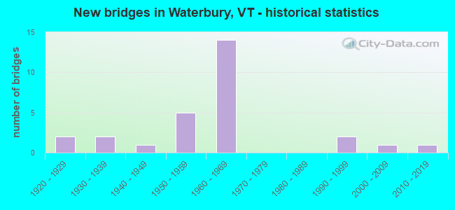
- New bridges - historical statistics
- 21920-1929
- 21930-1939
- 11940-1949
- 51950-1959
- 141960-1969
- 21990-1999
- 12000-2009
- 12010-2019

- Reconstructed bridges - Historical Statistics
- 11980-1989
- 81990-1999
- 02000-2009
- 22010-2019


- Bridge Condition - Deck
- 41.7%Very good
- 29.2%Good
- 16.7%Satisfactory
- 8.3%Fair
- 4.2%Poor

- Bridge Condition - Superstructure
- 33.3%Very good
- 29.2%Good
- 33.3%Satisfactory
- 4.2%Fair

- Bridge Condition - Substructure
- 20.8%Very good
- 54.2%Good
- 12.5%Satisfactory
- 8.3%Fair
- 4.2%Poor

- Bridge Condition - Channel
- 38.9%Very good
- 50.0%Good
- 11.1%Satisfactory
Find on map >> Show street view
Structure Number: 101218000212181, Location: 0.5 MI TO JCT W CL2 TH3 (Lat: 44.368919, Lng: -72.717653), Route carried "on" structure: Other road C2001, Year Built: 1944, Year Reconstructed: 1980, Status: Open, Structure Length: 1.68m (5.51ft), Average Daily Traffic: 1,060 (year 2019), Truck Traffic: 32%, Average Future Daily Traffic: 1,113 (year 2029), Design Load: H 15, Features Intersected: THATCHER BROOK
Minimum Vertical Clearance: 30+ m (98+ ft), Kilometerpoint: 0.000, Lanes on structure: 2, Owner: Town or Township Highway Agency, Approaching Roadway Width: 8.5m (27.9ft), Skew: 3 degrees, Material/Design: Steel, Design/Construction: Stringer/Multi-beam, Number Of Spans In Main Unit: 1, Length of Maximum Span: 15.8m (51.8ft), Curb or Sidewalk Widths: Left: 0.1m (0.3ft), Right: 0.1m (0.3ft), Curb-To-Curb Width: 7.9m (25.9ft), Out-to-Out Width: 8.4m (27.6ft)
Condition: Deck: Good, Superstructure: Good, Substructure: Good, Channel: Good, Operating Rating: 48.1 metric tons, Method Used To Determine Operating Rating: Allowable Stress (AS), Inventory Rating: 26.3 metric tons, Method Used To Determine Inventory Rating: Allowable Stress (AS), Structural Evaluation: Equal to present minimum criteria, Deck Geometry: Meets minimum limits, Waterway Adequacy: Better than present minimum criteria, Approach Roadway Alignment: Equal to present desirable criteria, Designated Inspection Frequency: Every 24 months, Inspection Date: September 2021, Deck Structure Type: Concrete Cast-file-Place, Wearing Surface/Protective System: Wearing Surface: Bituminous, Membrane: Preformed Fabric
Find on map >> Show street view
Structure Number: 101218000312181, Location: 0.3 MI TO JCT W VT100 (Lat: 44.355397, Lng: -72.729717), Route carried "on" structure: Other road C2001, Year Built: 1937, Status: Open, Structure Length: 1.65m (5.41ft), Average Daily Traffic: 1,060 (year 2019), Truck Traffic: 3%, Average Future Daily Traffic: 1,113 (year 2029), Design Load: H 15, Features Intersected: THATCHER BROOK
Minimum Vertical Clearance: 30+ m (98+ ft), Kilometerpoint: 0.000, Lanes on structure: 2, Owner: Town or Township Highway Agency, Approaching Roadway Width: 7.0m (23.0ft), Material/Design: Concrete, Design/Construction: Tee Beam, Number Of Spans In Main Unit: 1, Length of Maximum Span: 15.8m (51.8ft), Curb or Sidewalk Widths: Left: 0.2m (0.7ft), Right: 0.2m (0.7ft), Curb-To-Curb Width: 6.0m (19.7ft), Out-to-Out Width: 7.1m (23.3ft)
Condition: Deck: Good, Superstructure: Satisfactory, Substructure: Good, Channel: Good, Operating Rating: 60.8 metric tons, Method Used To Determine Operating Rating: Load Factor (LF), Inventory Rating: 36.3 metric tons, Method Used To Determine Inventory Rating: Load Factor (LF), Structural Evaluation: Equal to present minimum criteria, Deck Geometry: High priority of replacement, Waterway Adequacy: Equal to present minimum criteria, Approach Roadway Alignment: Equal to present minimum criteria, Length Of Structure Improvement: 1.65m (5.41ft), Designated Inspection Frequency: Every 24 months, Inspection Date: September 2021, Bridge Improvement Cost: $440,000, Roadway Improvement Cost: $50,000, Total Project Cost: $490,000 ( Estimate for 2020), Deck Structure Type: Concrete Cast-file-Place, Wearing Surface/Protective System: Wearing Surface: Bituminous
Find on map >> Show street view
Structure Number: 101218000412181, Location: 0.05 MI TO JCT W CL3 TH6 (Lat: 44.360678, Lng: -72.723953), Route carried "on" structure: Other road C2001, Year Built: 1953, Status: Open, Structure Length: 2.56m (8.40ft), Average Daily Traffic: 1,060 (year 2019), Truck Traffic: 3%, Average Future Daily Traffic: 1,113 (year 2029), Design Load: H 15, Features Intersected: THATCHER BROOK
Minimum Vertical Clearance: 30+ m (98+ ft), Kilometerpoint: 0.000, Lanes on structure: 2, Owner: Town or Township Highway Agency, Approaching Roadway Width: 7.6m (24.9ft), Material/Design: Steel, Design/Construction: Stringer/Multi-beam, Number Of Spans In Main Unit: 1, Length of Maximum Span: 25.0m (82.0ft), Curb or Sidewalk Widths: Left: 0.2m (0.7ft), Right: 0.2m (0.7ft), Curb-To-Curb Width: 7.7m (25.3ft), Out-to-Out Width: 8.3m (27.2ft)
Condition: Deck: Good, Superstructure: Satisfactory, Substructure: Good, Channel: Good, Operating Rating: 50.8 metric tons, Method Used To Determine Operating Rating: Allowable Stress (AS), Inventory Rating: 28.1 metric tons, Method Used To Determine Inventory Rating: Allowable Stress (AS), Structural Evaluation: Equal to present minimum criteria, Deck Geometry: Meets minimum limits, Waterway Adequacy: Better than present minimum criteria, Approach Roadway Alignment: Equal to present desirable criteria, Length Of Structure Improvement: 2.56m (8.40ft), Designated Inspection Frequency: Every 24 months, Inspection Date: September 2021, Bridge Improvement Cost: $803,000, Roadway Improvement Cost: $50,000, Total Project Cost: $853,000 ( Estimate for 2020), Deck Structure Type: Concrete Cast-file-Place, Wearing Surface/Protective System: Wearing Surface: Bituminous
Find on map >> Show street view
Structure Number: 101218000512181, Location: 0.01 MI TO JCT W VT100 (Lat: 44.355689, Lng: -72.735114), Route carried "on" structure: Other road C2001, Year Built: 1938, Status: Open, Structure Length: 2.10m (6.89ft), Average Daily Traffic: 1,060 (year 2019), Truck Traffic: 3%, Average Future Daily Traffic: 1,113 (year 2029), Design Load: H 15, Features Intersected: THATCHER BROOK
Minimum Vertical Clearance: 30+ m (98+ ft), Kilometerpoint: 0.000, Lanes on structure: 2, Owner: Town or Township Highway Agency, Approaching Roadway Width: 7.3m (24.0ft), Skew: 1 degrees, Material/Design: Steel, Design/Construction: Stringer/Multi-beam, Number Of Spans In Main Unit: 1, Length of Maximum Span: 20.4m (66.9ft), Curb or Sidewalk Widths: Left: 0.2m (0.7ft), Right: 0.2m (0.7ft), Curb-To-Curb Width: 6.3m (20.7ft), Out-to-Out Width: 7.1m (23.3ft)
Condition: Deck: Satisfactory, Superstructure: Satisfactory, Substructure: Good, Channel: Good, Operating Rating: 45.4 metric tons, Method Used To Determine Operating Rating: Load Factor (LF), Inventory Rating: 27.2 metric tons, Method Used To Determine Inventory Rating: Load Factor (LF), Structural Evaluation: Equal to present minimum criteria, Deck Geometry: High priority of replacement, Waterway Adequacy: Better than present minimum criteria, Approach Roadway Alignment: Equal to present desirable criteria, Length Of Structure Improvement: 2.10m (6.89ft), Designated Inspection Frequency: Every 24 months, Inspection Date: September 2021, Bridge Improvement Cost: $563,000, Roadway Improvement Cost: $50,000, Total Project Cost: $613,000 ( Estimate for 2020), Deck Structure Type: Concrete Cast-file-Place, Wearing Surface/Protective System: Wearing Surface: Bituminous
Find on map >> Show street view
Structure Number: 101218001412181, Location: 0.4 MI TO JCT W CL2 TH3 (Lat: 44.375631, Lng: -72.708403), Route carried "on" structure: Other road C3006, Year Built: 1954, Year Reconstructed: 2004, Status: Open, Structure Length: 1.19m (3.90ft), Average Daily Traffic: 649 (year 2019), Truck Traffic: 2%, Average Future Daily Traffic: 682 (year 2029), Design Load: HS 25 or greater, Features Intersected: THATCHER BROOK
Minimum Vertical Clearance: 30+ m (98+ ft), Kilometerpoint: 0.000, Lanes on structure: 2, Owner: Town or Township Highway Agency, Approaching Roadway Width: 7.3m (24.0ft), Material/Design: Prestressed concrete, Design/Construction: Slab, Number Of Spans In Main Unit: 1, Length of Maximum Span: 11.0m (36.1ft), Curb or Sidewalk Widths: Left: 0.1m (0.3ft), Right: 0.1m (0.3ft), Curb-To-Curb Width: 6.6m (21.7ft), Out-to-Out Width: 7.3m (24.0ft)
Condition: Deck: Very good, Superstructure: Very good, Substructure: Good, Channel: Good, Operating Rating: 89.8 metric tons, Method Used To Determine Operating Rating: Load Factor (LF), Inventory Rating: 64.4 metric tons, Method Used To Determine Inventory Rating: Load Factor (LF), Structural Evaluation: Better than present minimum criteria, Deck Geometry: High priority of corrective action, Waterway Adequacy: Better than present minimum criteria, Approach Roadway Alignment: Equal to present desirable criteria, Designated Inspection Frequency: Every 24 months, Inspection Date: September 2021, Deck Structure Type: Concrete Precast Panels, Wearing Surface/Protective System: Wearing Surface: Bituminous, Membrane: Preformed Fabric
Find on map >> Show street view
Structure Number: 101218001612181, Location: 0.02 MI TO JCT W VT100 (Lat: 44.349864, Lng: -72.741708), Route carried "on" structure: Other road C3021, Year Built: 1959, Status: Open, Structure Length: 1.98m (6.50ft), Average Daily Traffic: 150 (year 2019), Truck Traffic: 2%, Average Future Daily Traffic: 158 (year 2029), Design Load: H 15, Features Intersected: THATCHER BROOK
Minimum Vertical Clearance: 30+ m (98+ ft), Kilometerpoint: 0.000, Lanes on structure: 1, Owner: Town or Township Highway Agency, Approaching Roadway Width: 5.8m (19.0ft), Skew: 1 degrees, Material/Design: Steel, Design/Construction: Stringer/Multi-beam, Number Of Spans In Main Unit: 1, Length of Maximum Span: 18.9m (62.0ft), Curb or Sidewalk Widths: Left: 0.1m (0.3ft), Right: 0.1m (0.3ft), Curb-To-Curb Width: 4.0m (13.1ft), Out-to-Out Width: 4.2m (13.8ft)
Condition: Deck: Satisfactory, Superstructure: Satisfactory, Substructure: Satisfactory, Channel: Good, Operating Rating: 29.0 metric tons, Method Used To Determine Operating Rating: Allowable Stress (AS), Inventory Rating: 16.3 metric tons, Method Used To Determine Inventory Rating: Allowable Stress (AS), Structural Evaluation: Somewhat better than minimum adequacy, Deck Geometry: High priority of replacement, Waterway Adequacy: Better than present minimum criteria, Approach Roadway Alignment: Equal to present desirable criteria, Length Of Structure Improvement: 1.98m (6.50ft), Designated Inspection Frequency: Every 24 months, Inspection Date: September 2021, Bridge Improvement Cost: $316,000, Roadway Improvement Cost: $50,000, Total Project Cost: $366,000 ( Estimate for 2020), Deck Structure Type: Concrete Cast-file-Place, Wearing Surface/Protective System: Wearing Surface: Bituminous
Find on map >> Show street view
Structure Number: 101218003112181, Location: 0.01 MI TO JCT W CL2 TH1 (Lat: 44.337272, Lng: -72.764050), Route carried "on" structure: Other road C2004, Year Built: 1928, Year Reconstructed: 1997, Status: Open, Structure Length: 6.31m (20.70ft), Average Daily Traffic: 850 (year 2019), Truck Traffic: 3%, Average Future Daily Traffic: 893 (year 2029), Design Load: H 15, Features Intersected: WINOOSKI RIVER
Minimum Vertical Clearance: 4.47m (14.67ft), Kilometerpoint: 0.000, Lanes on structure: 2, Owner: Town or Township Highway Agency, Approaching Roadway Width: 7.6m (24.9ft), Material/Design: Steel, Design/Construction: Truss - Thru, Number Of Spans In Main Unit: 1, Length of Maximum Span: 61.6m (202.1ft), Curb or Sidewalk Widths: Left: 0.2m (0.7ft), Right: 1.6m (5.2ft), Curb-To-Curb Width: 6.1m (20.0ft), Out-to-Out Width: 6.5m (21.3ft)
Condition: Deck: Very good, Superstructure: Good, Substructure: Very good, Channel: Good, Operating Rating: 44.5 metric tons, Method Used To Determine Operating Rating: Load Factor (LF), Inventory Rating: 20.9 metric tons, Method Used To Determine Inventory Rating: Load Factor (LF), Structural Evaluation: Somewhat better than minimum adequacy, Deck Geometry: High priority of corrective action, Waterway Adequacy: Equal to present desirable criteria, Approach Roadway Alignment: Equal to present desirable criteria, Length Of Structure Improvement: 6.31m (20.70ft), Designated Inspection Frequency: Every 24 months, Critical Feature Inspection Frequency: Every 24 months, Inspection Date: September 2021, Critical Feature Inspection Date: September 2021, Bridge Improvement Cost: $1,536,000, Roadway Improvement Cost: $50,000, Total Project Cost: $1,586,000 ( Estimate for 2020), Deck Structure Type: Concrete Cast-file-Place, Wearing Surface/Protective System: Wearing Surface: Bituminous, Membrane: Preformed Fabric, Deck Protection: Epoxy Coated Reinforcing
Find on map >> Show street view
Structure Number: 101218003212181, Location: @ INTERS.OF US2 (Lat: 44.340939, Lng: -72.758886), Route carried "on" structure: Other road C2003, Year Built: 1997, Status: Open, Structure Length: 1.34m (4.40ft), Average Daily Traffic: 1,090 (year 2019), Truck Traffic: 2%, Average Future Daily Traffic: 1,145 (year 2029), Design Load: HS 25 or greater, Features Intersected: THATCHER BROOK
Minimum Vertical Clearance: 30+ m (98+ ft), Kilometerpoint: 0.000, Lanes on structure: 2, Owner: Town or Township Highway Agency, Approaching Roadway Width: 7.6m (24.9ft), Skew: 4 degrees, Material/Design: Concrete, Design/Construction: Slab, Number Of Spans In Main Unit: 1, Length of Maximum Span: 12.8m (42.0ft), Curb or Sidewalk Widths: Left: 1.6m (5.2ft), Right: 1.7m (5.6ft), Curb-To-Curb Width: 11.3m (37.1ft), Out-to-Out Width: 16.3m (53.5ft)
Condition: Deck: Very good, Superstructure: Very good, Substructure: Very good, Channel: Satisfactory, Operating Rating: 66.2 metric tons, Method Used To Determine Operating Rating: Allowable Stress (AS), Inventory Rating: 59.9 metric tons, Method Used To Determine Inventory Rating: Allowable Stress (AS), Structural Evaluation: Equal to present desirable criteria, Deck Geometry: Equal to present minimum criteria, Waterway Adequacy: Equal to present desirable criteria, Approach Roadway Alignment: Equal to present desirable criteria, Designated Inspection Frequency: Every 24 months, Inspection Date: September 2021, Deck Structure Type: Concrete Cast-file-Place, Wearing Surface/Protective System: Wearing Surface: Bituminous, Membrane: Preformed Fabric, Deck Protection: Epoxy Coated Reinforcing
Find on map >> Show street view
Structure Number: 101218003312181, Location: 0.04 MI TO JCT W UNION (Lat: 44.341042, Lng: -72.757656), Route carried "on" structure: Other road C3ARM, Year Built: 1960, Status: Open, Structure Length: 1.49m (4.89ft), Average Daily Traffic: 300 (year 2019), Truck Traffic: 2%, Average Future Daily Traffic: 315 (year 2029), Design Load: H 20, Features Intersected: THATCHER BROOK
Minimum Vertical Clearance: 30+ m (98+ ft), Kilometerpoint: 0.000, Lanes on structure: 2, Owner: Town or Township Highway Agency, Approaching Roadway Width: 8.5m (27.9ft), Skew: 3 degrees, Material/Design: Steel, Design/Construction: Stringer/Multi-beam, Number Of Spans In Main Unit: 1, Length of Maximum Span: 14.3m (46.9ft), Curb or Sidewalk Widths: Left: 1.5m (4.9ft), Right: 1.5m (4.9ft), Curb-To-Curb Width: 12.0m (39.4ft), Out-to-Out Width: 12.7m (41.7ft)
Condition: Deck: Satisfactory, Superstructure: Satisfactory, Substructure: Satisfactory, Channel: Satisfactory, Operating Rating: 35.4 metric tons, Method Used To Determine Operating Rating: Allowable Stress (AS), Inventory Rating: 20.9 metric tons, Method Used To Determine Inventory Rating: Allowable Stress (AS), Structural Evaluation: Equal to present minimum criteria, Deck Geometry: Superior to present desirable criteria, Waterway Adequacy: Better than present minimum criteria, Approach Roadway Alignment: Equal to present desirable criteria, Length Of Structure Improvement: 1.49m (4.89ft), Designated Inspection Frequency: Every 24 months, Inspection Date: September 2021, Bridge Improvement Cost: $713,000, Roadway Improvement Cost: $50,000, Total Project Cost: $763,000 ( Estimate for 2020), Deck Structure Type: Concrete Cast-file-Place, Wearing Surface/Protective System: Wearing Surface: Bituminous
Find on map >> Show street view
Structure Number: 101218003512181, Location: 0.07 MI TO JCT W CL1 TH1 (Lat: 44.338494, Lng: -72.755283), Route carried "on" structure: Other road C2002, Year Built: 2004, Status: Open, Structure Length: 1.19m (3.90ft), Average Daily Traffic: 3,300 (year 2019), Truck Traffic: 1%, Average Future Daily Traffic: 3,465 (year 2029), Design Load: HS 25 or greater, Features Intersected: NEW ENGLAND CENTRAL RR
Minimum Vertical Clearance: 30+ m (98+ ft), Kilometerpoint: 0.000, Lanes on structure: 2, Owner: Railroad, Approaching Roadway Width: 6.7m (22.0ft), Material/Design: Concrete, Design/Construction: Frame, Number Of Spans In Main Unit: 1, Length of Maximum Span: 10.7m (35.1ft), Curb or Sidewalk Widths: Left: 1.6m (5.2ft), Right: 1.6m (5.2ft), Curb-To-Curb Width: 8.6m (28.2ft), Out-to-Out Width: 12.6m (41.3ft)
Condition: Deck: Good, Superstructure: Good, Substructure: Good, Operating Rating: 77.1 metric tons, Method Used To Determine Operating Rating: Load Factor (LF), Inventory Rating: 45.4 metric tons, Method Used To Determine Inventory Rating: Load Factor (LF), Structural Evaluation: Better than present minimum criteria, Deck Geometry: Meets minimum limits, Underclear: High priority of corrective action, Approach Roadway Alignment: Equal to present desirable criteria, Length Of Structure Improvement: 1.19m (3.90ft), Designated Inspection Frequency: Every 24 months, Inspection Date: September 2021, Bridge Improvement Cost: $566,000, Roadway Improvement Cost: $50,000, Total Project Cost: $617,000 ( Estimate for 2020), Deck Structure Type: Concrete Cast-file-Place, Wearing Surface/Protective System: Wearing Surface: Bituminous, Membrane: Preformed Fabric, Deck Protection: Epoxy Coated Reinforcing
Find on map >> Show street view
Structure Number: 101218003612181, Location: 0.02 MI TO JCT W VT100 (Lat: 44.344389, Lng: -72.746933), Route carried "on" structure: Other road C2002, Year Built: 1928, Status: Open, Structure Length: 1.34m (4.40ft), Average Daily Traffic: 2,830 (year 2019), Truck Traffic: 2%, Average Future Daily Traffic: 2,972 (year 2029), Features Intersected: THATCHER BROOK
Minimum Vertical Clearance: 30+ m (98+ ft), Kilometerpoint: 0.000, Lanes on structure: 2, Owner: Town or Township Highway Agency, Approaching Roadway Width: 8.2m (26.9ft), Material/Design: Concrete, Design/Construction: Tee Beam, Number Of Spans In Main Unit: 1, Length of Maximum Span: 12.8m (42.0ft), Curb or Sidewalk Widths: Left: 1.6m (5.2ft), Right: 0.2m (0.7ft), Curb-To-Curb Width: 7.7m (25.3ft), Out-to-Out Width: 8.4m (27.6ft)
Condition: Deck: Fair, Superstructure: Fair, Substructure: Fair, Channel: Good, Operating Rating: 25.4 metric tons, Method Used To Determine Operating Rating: Load Factor (LF), Inventory Rating: 15.4 metric tons, Method Used To Determine Inventory Rating: Load Factor (LF), Structural Evaluation: Meets minimum limits, Deck Geometry: High priority of replacement, Waterway Adequacy: Equal to present minimum criteria, Approach Roadway Alignment: Equal to present desirable criteria, Length Of Structure Improvement: 2.13m (6.99ft), Designated Inspection Frequency: Every 24 months, Inspection Date: September 2021, Bridge Improvement Cost: $653,000, Roadway Improvement Cost: $150,000, Total Project Cost: $803,000 ( Estimate for 2020), Deck Structure Type: Concrete Cast-file-Place, Wearing Surface/Protective System: Wearing Surface: Bituminous
Find on map >> Show street view
Structure Number: 200013004712182, Location: 0.1 MI E JCT VT.100 N (Lat: 44.340864, Lng: -72.759103), Route carried "on" structure: US 2, Year Built: 1956, Status: Open, Structure Length: 1.19m (3.90ft), Average Daily Traffic: 9,200 (year 2018), Truck Traffic: 9%, Average Future Daily Traffic: 9,660 (year 2028), Design Load: H 20, Features Intersected: THATCHER BROOK
Minimum Vertical Clearance: 30+ m (98+ ft), Kilometerpoint: 103.903, Lanes on structure: 2, Base Highway Network: Yes, Owner: Town or Township Highway Agency, Approaching Roadway Width: 18.3m (60.0ft), Skew: 1 degrees, Material/Design: Steel, Design/Construction: Stringer/Multi-beam, Number Of Spans In Main Unit: 1, Length of Maximum Span: 11.3m (37.1ft), Curb or Sidewalk Widths: Left: 0.0m, Right: 1.5m (4.9ft), Curb-To-Curb Width: 13.4m (44.0ft), Out-to-Out Width: 18.6m (61.0ft)
Condition: Deck: Satisfactory, Superstructure: Satisfactory, Substructure: Satisfactory, Channel: Good, Operating Rating: 58.1 metric tons, Method Used To Determine Operating Rating: Load Factor (LF), Inventory Rating: 34.5 metric tons, Method Used To Determine Inventory Rating: Load Factor (LF), Structural Evaluation: Equal to present minimum criteria, Deck Geometry: Meets minimum limits, Waterway Adequacy: Better than present minimum criteria, Approach Roadway Alignment: Equal to present desirable criteria, Designated Inspection Frequency: Every 24 months, Inspection Date: June 2021, Deck Structure Type: Concrete Cast-file-Place, Wearing Surface/Protective System: Wearing Surface: Bituminous
Find on map >> Show street view
Structure Number: 200013004812182, Location: 0.2 M1 W JCT VT.100S (Lat: 44.328361, Lng: -72.746086), Route carried "on" structure: US 2, Year Built: 1992, Status: Open, Structure Length: 8.47m (27.79ft), Average Daily Traffic: 8,200 (year 2018), Truck Traffic: 9%, Average Future Daily Traffic: 8,610 (year 2028), Design Load: HS 25 or greater, Features Intersected: WINOOSKI RIVER
Minimum Vertical Clearance: 30+ m (98+ ft), Kilometerpoint: 105.641, Lanes on structure: 2, Base Highway Network: Yes, Owner: Town or Township Highway Agency, Approaching Roadway Width: 12.2m (40.0ft), Skew: 3 degrees, Material/Design: Steel continuous, Design/Construction: Stringer/Multi-beam, Number Of Spans In Main Unit: 2, Length of Maximum Span: 41.5m (136.2ft), Curb or Sidewalk Widths: Left: 0.1m (0.3ft), Right: 1.5m (4.9ft), Curb-To-Curb Width: 12.1m (39.7ft), Out-to-Out Width: 14.8m (48.6ft)
Condition: Deck: Good, Superstructure: Very good, Substructure: Very good, Channel: Very good, Operating Rating: 89.8 metric tons, Method Used To Determine Operating Rating: Allowable Stress (AS), Inventory Rating: 41.7 metric tons, Method Used To Determine Inventory Rating: Allowable Stress (AS), Structural Evaluation: Equal to present desirable criteria, Deck Geometry: Somewhat better than minimum adequacy, Waterway Adequacy: Equal to present desirable criteria, Approach Roadway Alignment: Equal to present desirable criteria, Designated Inspection Frequency: Every 24 months, Inspection Date: June 2021, Deck Structure Type: Concrete Cast-file-Place, Wearing Surface/Protective System: Wearing Surface: Bituminous, Membrane: Preformed Fabric, Deck Protection: Epoxy Coated Reinforcing
Find on map >> Show street view
Structure Number: 200013019712182, Location: I 89 EXIT 10 (Lat: 44.343344, Lng: -72.752578), Route carried "on" structure: State highway 100, Year Built: 1960, Status: Open, Structure Length: 7.44m (24.41ft), Average Daily Traffic: 13,400 (year 2018), Truck Traffic: 9%, Average Future Daily Traffic: 14,070 (year 2028), Design Load: HS 20, Features Intersected: I 89 UNDER VT 100
Minimum Vertical Clearance: 30+ m (98+ ft), Kilometerpoint: 229.445, Lanes on structure: 2, Lanes under structure: 4, Base Highway Network: Yes, Owner: State Highway Agency, Approaching Roadway Width: 16.5m (54.1ft), Skew: 23 degrees, Material/Design: Steel, Design/Construction: Stringer/Multi-beam, Number Of Spans In Main Unit: 4, Length of Maximum Span: 22.6m (74.1ft), Curb or Sidewalk Widths: Left: 0.2m (0.7ft), Right: 0.2m (0.7ft), Curb-To-Curb Width: 12.9m (42.3ft), Out-to-Out Width: 14.4m (47.2ft)
Condition: Deck: Fair, Superstructure: Satisfactory, Substructure: Fair, Operating Rating: 88.9 metric tons, Method Used To Determine Operating Rating: Load Factor (LF), Inventory Rating: 52.6 metric tons, Method Used To Determine Inventory Rating: Load Factor (LF), Structural Evaluation: Somewhat better than minimum adequacy, Deck Geometry: Somewhat better than minimum adequacy, Underclear: Somewhat better than minimum adequacy, Approach Roadway Alignment: Equal to present desirable criteria, Length Of Structure Improvement: 7.44m (24.41ft), Designated Inspection Frequency: Every 24 months, Inspection Date: May 2020, Bridge Improvement Cost: $4,039,000, Roadway Improvement Cost: $50,000, Total Project Cost: $4,089,000 ( Estimate for 2020), Deck Structure Type: Concrete Cast-file-Place, Wearing Surface/Protective System: Wearing Surface: Bituminous
Find on map >> Show street view
Structure Number: 200089046A12182, Location: 0.3 MI S EXIT 10 (Lat: 44.341486, Lng: -72.748489), Route carried "on" structure: Ramp Interstate 89, Year Built: 2016, Status: Open, Structure Length: 13.23m (43.41ft), Average Daily Traffic: 23,700 (year 2018), Truck Traffic: 7%, Average Future Daily Traffic: 24,885 (year 2028), Design Load: HL 93, Features Intersected: RAMP A OVER TH2 & BROOK
Minimum Vertical Clearance: 30+ m (98+ ft), Kilometerpoint: 102.220, Lanes on structure: 2, Lanes under structure: 2, Base Highway Network: Yes, Owner: State Highway Agency, Approaching Roadway Width: 6.1m (20.0ft), Skew: 10 degrees, Material/Design: Steel continuous, Design/Construction: Stringer/Multi-beam, Number Of Spans In Main Unit: 3, Length of Maximum Span: 57.3m (188.0ft), Curb or Sidewalk Widths: Left: 0.2m (0.7ft), Right: 0.2m (0.7ft), Curb-To-Curb Width: 9.8m (32.2ft), Out-to-Out Width: 10.7m (35.1ft)
Condition: Deck: Very good, Superstructure: Very good, Substructure: Very good, Channel: Very good, Operating Rating: 59.0 metric tons, Method Used To Determine Operating Rating: Load and Resistance Factor (LRFR), Inventory Rating: 45.4 metric tons, Method Used To Determine Inventory Rating: Load and Resistance Factor (LRFR), Structural Evaluation: Equal to present desirable criteria, Deck Geometry: Equal to present minimum criteria, Underclear: Better than present minimum criteria, Waterway Adequacy: Equal to present desirable criteria, Approach Roadway Alignment: Equal to present desirable criteria, Designated Inspection Frequency: Every 24 months, Inspection Date: May 2020, Deck Structure Type: Concrete Cast-file-Place, Wearing Surface/Protective System: Deck Protection: Other
Find on map >> Show street view
Structure Number: 200089046N12182, Location: 0.3 MI S EXIT 10 (Lat: 44.341339, Lng: -72.748878), Route carried "on" structure: Interstate 89, Year Built: 1960, Year Reconstructed: 2016, Status: Open, Structure Length: 11.58m (37.99ft), Average Daily Traffic: 23,700 (year 2018), Truck Traffic: 13%, Average Future Daily Traffic: 24,885 (year 2028), Design Load: HL 93, Features Intersected: I 89 OVER TH 2 & BRK
Minimum Vertical Clearance: 30+ m (98+ ft), Kilometerpoint: 102.220, Lanes on structure: 2, Lanes under structure: 2, Base Highway Network: Yes, Owner: State Highway Agency, Approaching Roadway Width: 12.2m (40.0ft), Skew: 13 degrees, Material/Design: Steel, Design/Construction: Stringer/Multi-beam, Number Of Spans In Main Unit: 5, Length of Maximum Span: 26.5m (86.9ft), Curb or Sidewalk Widths: Left: 0.2m (0.7ft), Right: 0.2m (0.7ft), Curb-To-Curb Width: 9.4m (30.8ft), Out-to-Out Width: 10.6m (34.8ft)
Condition: Deck: Good, Superstructure: Good, Substructure: Good, Channel: Very good, Operating Rating: 75.3 metric tons, Method Used To Determine Operating Rating: Load and Resistance Factor (LRFR), Inventory Rating: 58.1 metric tons, Method Used To Determine Inventory Rating: Load and Resistance Factor (LRFR), Structural Evaluation: Better than present minimum criteria, Deck Geometry: Meets minimum limits, Underclear: Somewhat better than minimum adequacy, Waterway Adequacy: Equal to present desirable criteria, Approach Roadway Alignment: Equal to present desirable criteria, Length Of Structure Improvement: 11.58m (37.99ft), Designated Inspection Frequency: Every 24 months, Inspection Date: May 2020, Bridge Improvement Cost: $4,642,000, Roadway Improvement Cost: $50,000, Total Project Cost: $4,692,000 ( Estimate for 2020), Deck Structure Type: Concrete Cast-file-Place, Wearing Surface/Protective System: Wearing Surface: Bituminous, Membrane: Preformed Fabric
Find on map >> Show street view
Structure Number: 200089046S12182, Location: 0.3 MI S EXIT 10 (Lat: 44.341289, Lng: -72.749183), Route carried "on" structure: Interstate 89, Year Built: 1960, Year Reconstructed: 2016, Status: Open, Structure Length: 11.28m (37.01ft), Average Daily Traffic: 23,700 (year 2018), Truck Traffic: 13%, Average Future Daily Traffic: 24,885 (year 2028), Design Load: HL 93, Features Intersected: I 89 OVER TH 2 & BRK
Minimum Vertical Clearance: 30+ m (98+ ft), Kilometerpoint: 102.220, Lanes on structure: 2, Lanes under structure: 2, Base Highway Network: Yes, Owner: State Highway Agency, Approaching Roadway Width: 11.6m (38.1ft), Skew: 13 degrees, Material/Design: Steel, Design/Construction: Stringer/Multi-beam, Number Of Spans In Main Unit: 5, Length of Maximum Span: 23.2m (76.1ft), Curb or Sidewalk Widths: Left: 0.2m (0.7ft), Right: 0.2m (0.7ft), Curb-To-Curb Width: 9.6m (31.5ft), Out-to-Out Width: 10.7m (35.1ft)
Condition: Deck: Good, Superstructure: Good, Substructure: Good, Channel: Very good, Operating Rating: 76.2 metric tons, Method Used To Determine Operating Rating: Load and Resistance Factor (LRFR), Inventory Rating: 59.0 metric tons, Method Used To Determine Inventory Rating: Load and Resistance Factor (LRFR), Structural Evaluation: Better than present minimum criteria, Deck Geometry: Meets minimum limits, Underclear: Meets minimum limits, Waterway Adequacy: Equal to present desirable criteria, Approach Roadway Alignment: Equal to present desirable criteria, Length Of Structure Improvement: 11.28m (37.01ft), Designated Inspection Frequency: Every 24 months, Inspection Date: May 2020, Bridge Improvement Cost: $4,545,000, Roadway Improvement Cost: $50,000, Total Project Cost: $4,596,000 ( Estimate for 2020), Deck Structure Type: Concrete Cast-file-Place, Wearing Surface/Protective System: Wearing Surface: Bituminous, Membrane: Preformed Fabric
Find on map >> Show street view
Structure Number: 200089048N12182, Location: 1.5 MI N EXIT 10 (Lat: 44.352603, Lng: -72.777875), Route carried "on" structure: Interstate 89, Year Built: 1961, Year Reconstructed: 2002, Status: Open, Structure Length: 9.14m (29.99ft), Average Daily Traffic: 28,200 (year 2018), Truck Traffic: 13%, Average Future Daily Traffic: 29,610 (year 2028), Design Load: HS 25 or greater, Features Intersected: LITTLE RIVER
Minimum Vertical Clearance: 30+ m (98+ ft), Kilometerpoint: 104.971, Lanes on structure: 2, Base Highway Network: Yes, Owner: State Highway Agency, Approaching Roadway Width: 11.3m (37.1ft), Skew: 12 degrees, Material/Design: Steel continuous, Design/Construction: Stringer/Multi-beam, Number Of Spans In Main Unit: 3, Length of Maximum Span: 30.2m (99.1ft), Curb or Sidewalk Widths: Left: 0.1m (0.3ft), Right: 0.1m (0.3ft), Curb-To-Curb Width: 9.8m (32.2ft), Out-to-Out Width: 11.0m (36.1ft)
Condition: Deck: Very good, Superstructure: Very good, Substructure: Good, Channel: Very good, Operating Rating: 74.4 metric tons, Method Used To Determine Operating Rating: Load Factor (LF), Inventory Rating: 44.5 metric tons, Method Used To Determine Inventory Rating: Load Factor (LF), Structural Evaluation: Better than present minimum criteria, Deck Geometry: Meets minimum limits, Waterway Adequacy: Equal to present desirable criteria, Approach Roadway Alignment: Equal to present desirable criteria, Designated Inspection Frequency: Every 24 months, Inspection Date: May 2020, Deck Structure Type: Concrete Cast-file-Place, Wearing Surface/Protective System: Wearing Surface: Bituminous, Membrane: Preformed Fabric, Deck Protection: Epoxy Coated Reinforcing
Find on map >> Show street view
Structure Number: 200089048S12182, Location: 1.5 MI N EXIT 10 (Lat: 44.352456, Lng: -72.778103), Route carried "on" structure: Interstate 89, Year Built: 1961, Year Reconstructed: 2001, Status: Open, Structure Length: 9.17m (30.09ft), Average Daily Traffic: 28,200 (year 2018), Truck Traffic: 13%, Average Future Daily Traffic: 29,610 (year 2028), Design Load: HS 25 or greater, Features Intersected: LITTLE RIVER
Minimum Vertical Clearance: 30+ m (98+ ft), Kilometerpoint: 104.971, Lanes on structure: 2, Base Highway Network: Yes, Owner: State Highway Agency, Approaching Roadway Width: 7.3m (24.0ft), Skew: 12 degrees, Material/Design: Steel continuous, Design/Construction: Stringer/Multi-beam, Number Of Spans In Main Unit: 3, Length of Maximum Span: 30.2m (99.1ft), Curb or Sidewalk Widths: Left: 0.1m (0.3ft), Right: 0.1m (0.3ft), Curb-To-Curb Width: 9.8m (32.2ft), Out-to-Out Width: 11.0m (36.1ft)
Condition: Deck: Very good, Superstructure: Very good, Substructure: Good, Channel: Very good, Operating Rating: 73.5 metric tons, Method Used To Determine Operating Rating: Load Factor (LF), Inventory Rating: 43.5 metric tons, Method Used To Determine Inventory Rating: Load Factor (LF), Structural Evaluation: Better than present minimum criteria, Deck Geometry: Meets minimum limits, Waterway Adequacy: Equal to present desirable criteria, Approach Roadway Alignment: Equal to present desirable criteria, Designated Inspection Frequency: Every 24 months, Inspection Date: May 2020, Deck Structure Type: Concrete Cast-file-Place, Wearing Surface/Protective System: Wearing Surface: Bituminous, Membrane: Preformed Fabric, Deck Protection: Epoxy Coated Reinforcing
Find on map >> Show street view
Structure Number: 200089049N12182, Location: 1.6 MI N EXIT 10 (Lat: 44.353089, Lng: -72.780553), Route carried "on" structure: Interstate 89, Year Built: 1961, Year Reconstructed: 2002, Status: Open, Structure Length: 3.08m (10.10ft), Average Daily Traffic: 28,200 (year 2018), Truck Traffic: 13%, Average Future Daily Traffic: 29,610 (year 2028), Design Load: HS 25 or greater, Features Intersected: I 89 OVER TH NO 7
Minimum Vertical Clearance: 30+ m (98+ ft), Kilometerpoint: 105.180, Lanes on structure: 2, Lanes under structure: 2, Base Highway Network: Yes, Owner: State Highway Agency, Approaching Roadway Width: 13.4m (44.0ft), Skew: 10 degrees, Material/Design: Steel, Design/Construction: Stringer/Multi-beam, Number Of Spans In Main Unit: 1, Length of Maximum Span: 29.6m (97.1ft), Curb or Sidewalk Widths: Left: 0.1m (0.3ft), Right: 0.1m (0.3ft), Curb-To-Curb Width: 13.4m (44.0ft), Out-to-Out Width: 14.6m (47.9ft)
Condition: Deck: Very good, Superstructure: Very good, Substructure: Good, Operating Rating: 89.8 metric tons, Method Used To Determine Operating Rating: Load Factor (LF), Inventory Rating: 68.9 metric tons, Method Used To Determine Inventory Rating: Load Factor (LF), Structural Evaluation: Better than present minimum criteria, Deck Geometry: Superior to present desirable criteria, Underclear: Equal to present minimum criteria, Approach Roadway Alignment: Equal to present desirable criteria, Designated Inspection Frequency: Every 24 months, Inspection Date: May 2020, Deck Structure Type: Concrete Cast-file-Place, Wearing Surface/Protective System: Wearing Surface: Bituminous, Membrane: Preformed Fabric, Deck Protection: Epoxy Coated Reinforcing
Find on map >> Show street view
Structure Number: 200089049S12182, Location: 1.6 MI N EXIT 10 (Lat: 44.352897, Lng: -72.780611), Route carried "on" structure: Interstate 89, Year Built: 1961, Year Reconstructed: 2001, Status: Open, Structure Length: 3.08m (10.10ft), Average Daily Traffic: 28,200 (year 2018), Truck Traffic: 13%, Average Future Daily Traffic: 29,610 (year 2028), Design Load: HS 25 or greater, Features Intersected: I 89 OVER TH NO 7
Minimum Vertical Clearance: 30+ m (98+ ft), Kilometerpoint: 105.180, Lanes on structure: 2, Lanes under structure: 2, Base Highway Network: Yes, Owner: State Highway Agency, Approaching Roadway Width: 13.4m (44.0ft), Skew: 10 degrees, Material/Design: Steel, Design/Construction: Stringer/Multi-beam, Number Of Spans In Main Unit: 1, Length of Maximum Span: 29.6m (97.1ft), Curb or Sidewalk Widths: Left: 0.1m (0.3ft), Right: 0.1m (0.3ft), Curb-To-Curb Width: 13.4m (44.0ft), Out-to-Out Width: 14.6m (47.9ft)
Condition: Deck: Very good, Superstructure: Very good, Substructure: Good, Operating Rating: 89.8 metric tons, Method Used To Determine Operating Rating: Load Factor (LF), Inventory Rating: 68.9 metric tons, Method Used To Determine Inventory Rating: Load Factor (LF), Structural Evaluation: Better than present minimum criteria, Deck Geometry: Superior to present desirable criteria, Underclear: Equal to present minimum criteria, Approach Roadway Alignment: Equal to present desirable criteria, Designated Inspection Frequency: Every 24 months, Inspection Date: May 2020, Deck Structure Type: Concrete Cast-file-Place, Wearing Surface/Protective System: Wearing Surface: Bituminous, Membrane: Preformed Fabric, Deck Protection: Epoxy Coated Reinforcing
Find on map >> Show street view
Structure Number: 200089050N12182, Location: 2.8 MI N EXIT 10 (Lat: 44.361261, Lng: -72.803383), Route carried "on" structure: Interstate 89, Year Built: 1961, Year Reconstructed: 2002, Status: Open, Structure Length: 7.25m (23.79ft), Average Daily Traffic: 28,200 (year 2018), Truck Traffic: 13%, Average Future Daily Traffic: 29,610 (year 2028), Design Load: HS 25 or greater, Features Intersected: I 89 OVER US 2
Minimum Vertical Clearance: 30+ m (98+ ft), Kilometerpoint: 107.224, Lanes on structure: 2, Lanes under structure: 2, Base Highway Network: Yes, Owner: State Highway Agency, Approaching Roadway Width: 11.6m (38.1ft), Skew: 14 degrees, Material/Design: Steel continuous, Design/Construction: Stringer/Multi-beam, Number Of Spans In Main Unit: 3, Length of Maximum Span: 29.6m (97.1ft), Curb or Sidewalk Widths: Left: 0.1m (0.3ft), Right: 0.1m (0.3ft), Curb-To-Curb Width: 9.8m (32.2ft), Out-to-Out Width: 11.0m (36.1ft)
Condition: Deck: Very good, Superstructure: Good, Substructure: Very good, Operating Rating: 77.1 metric tons, Method Used To Determine Operating Rating: Load Factor (LF), Inventory Rating: 46.3 metric tons, Method Used To Determine Inventory Rating: Load Factor (LF), Structural Evaluation: Better than present minimum criteria, Deck Geometry: Meets minimum limits, Underclear: Superior to present desirable criteria, Approach Roadway Alignment: Equal to present desirable criteria, Designated Inspection Frequency: Every 24 months, Inspection Date: May 2020, Deck Structure Type: Concrete Cast-file-Place, Wearing Surface/Protective System: Wearing Surface: Bituminous, Membrane: Preformed Fabric, Deck Protection: Epoxy Coated Reinforcing
Find on map >> Show street view
Structure Number: 200089050S12182, Location: 2.8 MI N EXIT 10 (Lat: 44.361033, Lng: -72.803136), Route carried "on" structure: Interstate 89, Year Built: 1961, Year Reconstructed: 2001, Status: Open, Structure Length: 6.86m (22.51ft), Average Daily Traffic: 28,200 (year 2018), Truck Traffic: 13%, Average Future Daily Traffic: 29,610 (year 2028), Design Load: HS 20, Features Intersected: I 89 OVER US 2
Minimum Vertical Clearance: 30+ m (98+ ft), Kilometerpoint: 107.224, Lanes on structure: 2, Lanes under structure: 2, Base Highway Network: Yes, Owner: State Highway Agency, Approaching Roadway Width: 11.9m (39.0ft), Skew: 14 degrees, Material/Design: Steel continuous, Design/Construction: Stringer/Multi-beam, Number Of Spans In Main Unit: 3, Length of Maximum Span: 27.7m (90.9ft), Curb or Sidewalk Widths: Left: 0.1m (0.3ft), Right: 0.1m (0.3ft), Curb-To-Curb Width: 9.8m (32.2ft), Out-to-Out Width: 11.0m (36.1ft)
Condition: Deck: Very good, Superstructure: Good, Substructure: Good, Operating Rating: 78.0 metric tons, Method Used To Determine Operating Rating: Load Factor (LF), Inventory Rating: 46.3 metric tons, Method Used To Determine Inventory Rating: Load Factor (LF), Structural Evaluation: Better than present minimum criteria, Deck Geometry: Meets minimum limits, Underclear: Better than present minimum criteria, Approach Roadway Alignment: Equal to present desirable criteria, Designated Inspection Frequency: Every 24 months, Inspection Date: May 2020, Deck Structure Type: Concrete Cast-file-Place, Wearing Surface/Protective System: Wearing Surface: Bituminous, Membrane: Preformed Fabric, Deck Protection: Epoxy Coated Reinforcing
Find on map >> Show street view
Structure Number: 200284004412182, Location: 1.3 MI W JCT VT.100 N (Lat: 44.352178, Lng: -72.778447), Route carried "on" structure: US 2, Year Built: 1961, Status: Open, Structure Length: 7.41m (24.31ft), Average Daily Traffic: 5,600 (year 2018), Truck Traffic: 6%, Average Future Daily Traffic: 5,880 (year 2028), Design Load: HS 20, Features Intersected: LITTLE RIVER
Minimum Vertical Clearance: 30+ m (98+ ft), Kilometerpoint: 0.000, Lanes on structure: 2, Owner: State Highway Agency, Approaching Roadway Width: 9.8m (32.2ft), Skew: 2 degrees, Material/Design: Steel, Design/Construction: Stringer/Multi-beam, Number Of Spans In Main Unit: 3, Length of Maximum Span: 29.6m (97.1ft), Curb or Sidewalk Widths: Left: 0.2m (0.7ft), Right: 0.2m (0.7ft), Curb-To-Curb Width: 9.1m (29.9ft), Out-to-Out Width: 10.7m (35.1ft)
Condition: Deck: Poor, Superstructure: Satisfactory, Substructure: Poor, Channel: Very good, Operating Rating: 88.0 metric tons, Method Used To Determine Operating Rating: Load Factor (LF), Inventory Rating: 52.6 metric tons, Method Used To Determine Inventory Rating: Load Factor (LF), Structural Evaluation: Meets minimum limits, Deck Geometry: Meets minimum limits, Waterway Adequacy: Equal to present desirable criteria, Approach Roadway Alignment: Equal to present desirable criteria, Length Of Structure Improvement: 7.41m (24.31ft), Designated Inspection Frequency: Every 12 months, Inspection Date: April 2021, Bridge Improvement Cost: $2,994,000, Roadway Improvement Cost: $50,000, Total Project Cost: $3,044,000 ( Estimate for 2020), Deck Structure Type: Concrete Cast-file-Place, Wearing Surface/Protective System: Wearing Surface: Bituminous, Membrane: Preformed Fabric
Find on map >> Show street view
Structure Number: 200013004612182, Location: 0.1 MI E JCT VT.100 N (Lat: 44.340925, Lng: -72.759136), Route carried "under" structure: US 2, Year Built: 1956, Structure Length: 0. m, Average Daily Traffic: 10,900 (year 1998), Truck Traffic: 9%, Features Intersected: N.E.C.R.R. OVER US 2, Facility Carried by Structure: RAILROAD
Kilometerpoint: 103.903, Material/Design: Steel, Design/Construction: Girder and Floorbeam System, Length of Maximum Span: 36.6m (120.1ft)
Find on map >> Show street view
Structure Number: 200013019712182, Location: I 89 EXIT 10 (Lat: 44.343344, Lng: -72.752578), Route carried "under" structure: Interstate 89, Year Built: 1960, Structure Length: 0. m, Average Daily Traffic: 22,850 (year 1998), Truck Traffic: 13%, Features Intersected: I 89 UNDER VT 100, Facility Carried by Structure: VT 00100 ML
Minimum Vertical Clearance: 5.58m (18.31ft), Kilometerpoint: 165.098, Lanes on structure: 2, Material/Design: Steel, Design/Construction: Stringer/Multi-beam, Length of Maximum Span: 22.6m (74.1ft)
Find on map >> Show street view
Structure Number: 200089050N12182, Location: 2.8 MI N EXIT 10 (Lat: 44.361261, Lng: -72.803383), Route carried "under" structure: US 2, Year Built: 1961, Structure Length: 0. m, Average Daily Traffic: 1,900 (year 1998), Truck Traffic: 9%, Features Intersected: I 89 OVER U.S.2, Facility Carried by Structure: I 00089 ML
Minimum Vertical Clearance: 5.66m (18.57ft), Kilometerpoint: 99.607, Lanes on structure: 2, Material/Design: Steel continuous, Design/Construction: Stringer/Multi-beam, Length of Maximum Span: 28.3m (92.8ft)
Find on map >> Show street view
Structure Number: 200089050S12182, Location: 2.8 MI N EXIT 10 (Lat: 44.361033, Lng: -72.803136), Route carried "under" structure: US 2, Year Built: 1961, Structure Length: 0. m, Average Daily Traffic: 1,900 (year 1998), Truck Traffic: 9%, Features Intersected: I 89 OVER U.S.2, Facility Carried by Structure: I 00089 ML
Minimum Vertical Clearance: 4.95m (16.24ft), Kilometerpoint: 99.607, Lanes on structure: 2, Material/Design: Steel continuous, Design/Construction: Stringer/Multi-beam, Length of Maximum Span: 28.3m (92.8ft)