Bridge Statistics for Waterville, Ohio (OH)
Condition, Traffic, Stress, Structural Evaluation, Project Costs
- National Bridge Inventory (NBI) Statistics
- 21Number of bridges
- 259ft / 78.8mTotal length
- 193,621Total average daily traffic
- 56,902Total average daily truck traffic
- National Bridge Inventory (NBI) Registered Bridges for Waterville
- No street view available for this location
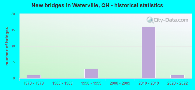
- New bridges - historical statistics
- 11970-1979
- 31990-1999
- 162010-2019
- 12020-2022


- Bridge Condition - Deck
- 23.1%Excellent
- 53.8%Very good
- 15.4%Good
- 7.7%Satisfactory

- Bridge Condition - Superstructure
- 23.1%Excellent
- 53.8%Very good
- 15.4%Good
- 7.7%Poor

- Bridge Condition - Substructure
- 15.4%Excellent
- 69.2%Very good
- 15.4%Good

- Bridge Condition - Channel
- 40.0%Excellent
- 60.0%Satisfactory
Find on map >> Show street view
Structure Number: 4801342, Location: JCT USR 24 & NEOWASH ROAD (Lat: 41.474069, Lng: -83.776789), Route carried "on" structure: County highway C0143, Year Built: 2010, Status: Open, Structure Length: 5.58m (18.31ft), Average Daily Traffic: 450 (year 2008), Truck Traffic: 5%, Average Future Daily Traffic: 15,004 (year 2028), Design Load: HS 25 or greater, Features Intersected: USR 24, Facility Carried by Structure: NEOWASH ROAD
Minimum Vertical Clearance: 30+ m (98+ ft), Kilometerpoint: 8.847, Lanes on structure: 2, Lanes under structure: 4, Owner: State Highway Agency, Approaching Roadway Width: 7.3m (24.0ft), Material/Design: Prestressed concrete continuous, Design/Construction: Stringer/Multi-beam, Number Of Spans In Main Unit: 2, Length of Maximum Span: 27.4m (89.9ft), Curb-To-Curb Width: 11.0m (36.1ft), Out-to-Out Width: 11.9m (39.0ft)
Condition: Deck: Very good, Superstructure: Very good, Substructure: Very good, Operating Rating: 42.1 metric tons, Method Used To Determine Operating Rating: Load Factor (LF) rating reported by rating factor (RF) method using MS18 loading, Inventory Rating: 32.4 metric tons, Method Used To Determine Inventory Rating: Load Factor (LF) rating reported by rating factor (RF) method using MS18 loading, Structural Evaluation: Equal to present desirable criteria, Deck Geometry: Better than present minimum criteria, Underclear: Equal to present desirable criteria, Approach Roadway Alignment: Equal to present desirable criteria, Designated Inspection Frequency: Every 24 months, Inspection Date: March 2021, Deck Structure Type: Concrete Cast-file-Place, Wearing Surface/Protective System: Wearing Surface: Monolithic Concrete, Deck Protection: Epoxy Coated Reinforcing
Find on map >> Show street view
Structure Number: 4801415, Location: JCT CR 136 & USR 24 (Lat: 41.496111, Lng: -83.764439), Route carried "on" structure: County highway C0136, Year Built: 2010, Status: Open, Structure Length: 7.74m (25.39ft), Average Daily Traffic: 1,570 (year 2019), Truck Traffic: 5%, Average Future Daily Traffic: 1,700 (year 2039), Design Load: HS 25 or greater, Features Intersected: USR 24, Facility Carried by Structure: CR 136
Minimum Vertical Clearance: 30+ m (98+ ft), Kilometerpoint: 9.125, Lanes on structure: 2, Lanes under structure: 4, Owner: State Highway Agency, Approaching Roadway Width: 10.1m (33.1ft), Skew: 4 degrees, Material/Design: Prestressed concrete continuous, Design/Construction: Stringer/Multi-beam, Number Of Spans In Main Unit: 2, Length of Maximum Span: 37.5m (123.0ft), Curb-To-Curb Width: 12.2m (40.0ft), Out-to-Out Width: 13.1m (43.0ft)
Condition: Deck: Excellent, Superstructure: Excellent, Substructure: Very good, Operating Rating: 97.2 metric tons, Method Used To Determine Operating Rating: Load Factor (LF) rating reported by rating factor (RF) method using MS18 loading, Inventory Rating: 32.4 metric tons, Method Used To Determine Inventory Rating: Load Factor (LF) rating reported by rating factor (RF) method using MS18 loading, Structural Evaluation: Equal to present desirable criteria, Deck Geometry: Better than present minimum criteria, Underclear: Equal to present desirable criteria, Approach Roadway Alignment: Equal to present desirable criteria, Designated Inspection Frequency: Every 24 months, Inspection Date: March 2021, Deck Structure Type: Concrete Cast-file-Place, Wearing Surface/Protective System: Wearing Surface: Monolithic Concrete, Deck Protection: Epoxy Coated Reinforcing
Find on map >> Show street view
Structure Number: 4801423, Location: JCT US 24 & DUTCH RD (Lat: 41.521811, Lng: -83.742081), Route carried "on" structure: US 24, Year Built: 2011, Status: Open, Structure Length: 6.10m (20.01ft), Average Daily Traffic: 12,530 (year 2019), Truck Traffic: 39%, Average Future Daily Traffic: 15,000 (year 2039), Design Load: HS 25 or greater, Features Intersected: CR 133 DUTCH RD.
Minimum Vertical Clearance: 30+ m (98+ ft), Kilometerpoint: 17.091, Lanes on structure: 2, Lanes under structure: 2, Base Highway Network: Yes, Owner: State Highway Agency, Approaching Roadway Width: 12.2m (40.0ft), Skew: 5 degrees, Material/Design: Prestressed concrete continuous, Design/Construction: Stringer/Multi-beam, Number Of Spans In Main Unit: 3, Length of Maximum Span: 24.7m (81.0ft), Curb-To-Curb Width: 15.9m (52.2ft), Out-to-Out Width: 16.8m (55.1ft)
Condition: Deck: Very good, Superstructure: Very good, Substructure: Very good, Operating Rating: 51.8 metric tons, Method Used To Determine Operating Rating: Load and Resistance Factor Rating (LRFR) rating reported by rating factor(RF) method using HL-93 loadings, Inventory Rating: 22.7 metric tons, Method Used To Determine Inventory Rating: Load and Resistance Factor Rating (LRFR) rating reported by rating factor(RF) method using HL-93 loadings, Structural Evaluation: Somewhat better than minimum adequacy, Deck Geometry: Superior to present desirable criteria, Underclear: Better than present minimum criteria, Approach Roadway Alignment: Equal to present desirable criteria, Designated Inspection Frequency: Every 24 months, Inspection Date: March 2021, Deck Structure Type: Concrete Cast-file-Place, Wearing Surface/Protective System: Wearing Surface: Monolithic Concrete, Deck Protection: Epoxy Coated Reinforcing
Find on map >> Show street view
Structure Number: 4801431, Location: JCT USR 24 & DUTCH ROAD (Lat: 41.521819, Lng: -83.741589), Route carried "on" structure: US 24, Year Built: 2011, Status: Open, Structure Length: 6.25m (20.51ft), Average Daily Traffic: 12,530 (year 2019), Truck Traffic: 39%, Average Future Daily Traffic: 15,000 (year 2039), Design Load: HS 25 or greater, Features Intersected: CR 133
Minimum Vertical Clearance: 30+ m (98+ ft), Kilometerpoint: 17.091, Lanes on structure: 2, Lanes under structure: 2, Base Highway Network: Yes, Owner: State Highway Agency, Approaching Roadway Width: 12.2m (40.0ft), Skew: 5 degrees, Material/Design: Prestressed concrete continuous, Design/Construction: Stringer/Multi-beam, Number Of Spans In Main Unit: 3, Length of Maximum Span: 25.6m (84.0ft), Curb-To-Curb Width: 13.4m (44.0ft), Out-to-Out Width: 14.3m (46.9ft)
Condition: Deck: Very good, Superstructure: Very good, Substructure: Very good, Operating Rating: 61.6 metric tons, Method Used To Determine Operating Rating: Load Factor (LF) rating reported by rating factor (RF) method using MS18 loading, Inventory Rating: 32.4 metric tons, Method Used To Determine Inventory Rating: Load Factor (LF) rating reported by rating factor (RF) method using MS18 loading, Structural Evaluation: Equal to present desirable criteria, Deck Geometry: Superior to present desirable criteria, Underclear: Equal to present desirable criteria, Approach Roadway Alignment: Equal to present desirable criteria, Designated Inspection Frequency: Every 24 months, Inspection Date: March 2021, Deck Structure Type: Concrete Cast-file-Place, Wearing Surface/Protective System: Wearing Surface: Monolithic Concrete, Deck Protection: Epoxy Coated Reinforcing
Find on map >> Show street view
Structure Number: 4801458, Location: JCT USR 24 & CR 124 (Lat: 41.524461, Lng: -83.733139), Route carried "on" structure: US 24, Year Built: 2011, Status: Open, Structure Length: 3.93m (12.89ft), Average Daily Traffic: 12,530 (year 2019), Truck Traffic: 39%, Average Future Daily Traffic: 15,500 (year 2039), Design Load: HS 25 or greater, Features Intersected: CR 124
Minimum Vertical Clearance: 30+ m (98+ ft), Kilometerpoint: 17.880, Lanes on structure: 2, Lanes under structure: 2, Base Highway Network: Yes, Owner: State Highway Agency, Approaching Roadway Width: 12.2m (40.0ft), Skew: 1 degrees, Material/Design: Prestressed concrete continuous, Design/Construction: Stringer/Multi-beam, Number Of Spans In Main Unit: 3, Length of Maximum Span: 15.9m (52.2ft), Curb-To-Curb Width: 13.4m (44.0ft), Out-to-Out Width: 14.3m (46.9ft)
Condition: Deck: Very good, Superstructure: Very good, Substructure: Very good, Operating Rating: 68.0 metric tons, Method Used To Determine Operating Rating: Load Factor (LF) rating reported by rating factor (RF) method using MS18 loading, Inventory Rating: 32.4 metric tons, Method Used To Determine Inventory Rating: Load Factor (LF) rating reported by rating factor (RF) method using MS18 loading, Structural Evaluation: Equal to present desirable criteria, Deck Geometry: Superior to present desirable criteria, Underclear: Equal to present minimum criteria, Approach Roadway Alignment: Equal to present desirable criteria, Designated Inspection Frequency: Every 24 months, Inspection Date: March 2021, Deck Structure Type: Concrete Cast-file-Place, Wearing Surface/Protective System: Wearing Surface: Monolithic Concrete, Deck Protection: Epoxy Coated Reinforcing
Find on map >> Show street view
Structure Number: 4801466, Location: JCT USR 24 & CR 124 (Lat: 41.524211, Lng: -83.733139), Route carried "on" structure: US 24, Year Built: 2011, Status: Open, Structure Length: 3.93m (12.89ft), Average Daily Traffic: 12,530 (year 2019), Truck Traffic: 39%, Average Future Daily Traffic: 15,500 (year 2039), Design Load: HS 25 or greater, Features Intersected: CR 124
Minimum Vertical Clearance: 30+ m (98+ ft), Kilometerpoint: 17.880, Lanes on structure: 2, Lanes under structure: 2, Base Highway Network: Yes, Owner: State Highway Agency, Approaching Roadway Width: 12.2m (40.0ft), Skew: 1 degrees, Material/Design: Prestressed concrete continuous, Design/Construction: Stringer/Multi-beam, Number Of Spans In Main Unit: 3, Length of Maximum Span: 15.9m (52.2ft), Curb-To-Curb Width: 13.4m (44.0ft), Out-to-Out Width: 14.3m (46.9ft)
Condition: Deck: Very good, Superstructure: Very good, Substructure: Very good, Operating Rating: 68.0 metric tons, Method Used To Determine Operating Rating: Load Factor (LF) rating reported by rating factor (RF) method using MS18 loading, Inventory Rating: 32.4 metric tons, Method Used To Determine Inventory Rating: Load Factor (LF) rating reported by rating factor (RF) method using MS18 loading, Structural Evaluation: Equal to present desirable criteria, Deck Geometry: Superior to present desirable criteria, Underclear: Equal to present minimum criteria, Approach Roadway Alignment: Equal to present desirable criteria, Designated Inspection Frequency: Every 24 months, Inspection Date: March 2021, Deck Structure Type: Concrete Cast-file-Place, Wearing Surface/Protective System: Wearing Surface: Monolithic Concrete, Deck Protection: Epoxy Coated Reinforcing
Find on map >> Show street view
Structure Number: 480152, Location: 0.4 Mi. N. OF DUTCH RD (Lat: 41.528150, Lng: -83.716800), Route carried "on" structure: US 24, Year Built: 2012, Status: Open, Structure Length: 4.85m (15.91ft), Average Daily Traffic: 26,059 (year 2019), Truck Traffic: 39%, Average Future Daily Traffic: 31,500 (year 2039), Design Load: HS 25 or greater, Features Intersected: ANTHONY WAYNE TRAIL N&SR
Minimum Vertical Clearance: 30+ m (98+ ft), Kilometerpoint: 19.360, Lanes on structure: 4, Lanes under structure: 2, Base Highway Network: Yes, Owner: State Highway Agency, Approaching Roadway Width: 14.6m (47.9ft), Skew: 35 degrees, Material/Design: Concrete continuous, Design/Construction: Slab, Number Of Spans In Main Unit: 2, Length of Maximum Span: 24.7m (81.0ft), Curb-To-Curb Width: 30.8m (101.0ft), Out-to-Out Width: 31.7m (104.0ft)
Condition: Deck: Very good, Superstructure: Very good, Substructure: Very good, Operating Rating: 42.1 metric tons, Method Used To Determine Operating Rating: Load Factor (LF) rating reported by rating factor (RF) method using MS18 loading, Inventory Rating: 32.4 metric tons, Method Used To Determine Inventory Rating: Load Factor (LF) rating reported by rating factor (RF) method using MS18 loading, Structural Evaluation: Equal to present desirable criteria, Deck Geometry: Superior to present desirable criteria, Underclear: Equal to present minimum criteria, Approach Roadway Alignment: Equal to present desirable criteria, Designated Inspection Frequency: Every 24 months, Inspection Date: March 2021, Deck Structure Type: Concrete Cast-file-Place, Wearing Surface/Protective System: Wearing Surface: Bituminous, Deck Protection: Epoxy Coated Reinforcing
Find on map >> Show street view
Structure Number: 4802489, Location: JCT USR 24 & SR 64 (Lat: 41.508331, Lng: -83.754169), Route carried "on" structure: State highway 64, Year Built: 2011, Status: Open, Structure Length: 5.58m (18.31ft), Average Daily Traffic: 10,354 (year 2019), Truck Traffic: 4%, Average Future Daily Traffic: 13,500 (year 2039), Design Load: HS 25 or greater, Features Intersected: US 24
Minimum Vertical Clearance: 30+ m (98+ ft), Kilometerpoint: 3.701, Lanes on structure: 3, Lanes under structure: 4, Owner: State Highway Agency, Approaching Roadway Width: 16.2m (53.1ft), Material/Design: Prestressed concrete continuous, Design/Construction: Stringer/Multi-beam, Number Of Spans In Main Unit: 2, Length of Maximum Span: 27.4m (89.9ft), Curb or Sidewalk Widths: Left: 1.8m (5.9ft), Right: 0.0m, Curb-To-Curb Width: 17.1m (56.1ft), Out-to-Out Width: 19.7m (64.6ft)
Condition: Deck: Very good, Superstructure: Very good, Substructure: Very good, Operating Rating: 42.1 metric tons, Method Used To Determine Operating Rating: Load Factor (LF) rating reported by rating factor (RF) method using MS18 loading, Inventory Rating: 32.4 metric tons, Method Used To Determine Inventory Rating: Load Factor (LF) rating reported by rating factor (RF) method using MS18 loading, Structural Evaluation: Equal to present desirable criteria, Deck Geometry: Superior to present desirable criteria, Underclear: Better than present minimum criteria, Approach Roadway Alignment: Equal to present desirable criteria, Designated Inspection Frequency: Every 24 months, Inspection Date: March 2021, Deck Structure Type: Concrete Cast-file-Place, Wearing Surface/Protective System: Wearing Surface: Monolithic Concrete, Deck Protection: Epoxy Coated Reinforcing
Find on map >> Show street view
Structure Number: 4832493, Location: 0.47 MI. S. OF STITT RD. (Lat: 41.530039, Lng: -83.732950), Route carried "on" structure: County highway C0124, Year Built: 1991, Status: Open, Structure Length: 0.73m (2.40ft), Average Daily Traffic: 3,613 (year 2015), Truck Traffic: 5%, Average Future Daily Traffic: 5,015 (year 2035), Design Load: HS 20+Mod, Features Intersected: BLYSTONE DITCH 0817, Facility Carried by Structure: WATERVILLE-MON.
Minimum Vertical Clearance: 30+ m (98+ ft), Kilometerpoint: 13.148, Lanes on structure: 2, Owner: County Highway Agency, Approaching Roadway Width: 11.6m (38.1ft), Skew: 3 degrees, Material/Design: Concrete, Design/Construction: Frame, Number Of Spans In Main Unit: 1, Length of Maximum Span: 7.0m (23.0ft), Curb-To-Curb Width: 19.0m (62.3ft), Out-to-Out Width: 19.5m (64.0ft)
Condition: Deck: Excellent, Superstructure: Excellent, Substructure: Excellent, Channel: Excellent, Operating Rating: 42.1 metric tons, Method Used To Determine Operating Rating: Allowable Stress (AS) rating reported by rating factor (RF) method using MS18 loading, Inventory Rating: 32.4 metric tons, Method Used To Determine Inventory Rating: Allowable Stress (AS) rating reported by rating factor (RF) method using MS18 loading, Structural Evaluation: Equal to present desirable criteria, Deck Geometry: Superior to present desirable criteria, Waterway Adequacy: Superior to present desirable criteria, Approach Roadway Alignment: Superior to present desirable criteria, Designated Inspection Frequency: Every 24 months, Inspection Date: October 2021, Deck Structure Type: Concrete Cast-file-Place, Wearing Surface/Protective System: Wearing Surface: Bituminous, Membrane: Built-up, Deck Protection: Other
Find on map >> Show street view
Structure Number: 8702463, Location: 2.0 South of US 24 (Lat: 41.499939, Lng: -83.711889), Route carried "on" structure: State highway 64, Year Built: 2020, Status: Open, Structure Length: 29.53m (96.88ft), Average Daily Traffic: 11,900 (year 2018), Truck Traffic: 3%, Average Future Daily Traffic: 15,541 (year 2038), Design Load: HL 93, Features Intersected: MAUMEE RIVER
Minimum Vertical Clearance: 30+ m (98+ ft), Kilometerpoint: 19.360, Lanes on structure: 2, Owner: State Highway Agency, Approaching Roadway Width: 9.8m (32.2ft), Navigation Control: Yes ( Vertical Clearance: 4.4m (14.4ft), Horizontal Clearance: 34.3m (112.5ft)), Material/Design: Prestressed concrete, Design/Construction: Stringer/Multi-beam, Number Of Spans In Main Unit: 8, Length of Maximum Span: 36.1m (118.4ft), Curb or Sidewalk Widths: Left: 2.1m (6.9ft), Right: 3.7m (12.1ft), Curb-To-Curb Width: 9.8m (32.2ft), Out-to-Out Width: 17.3m (56.8ft)
Condition: Deck: Excellent, Superstructure: Excellent, Substructure: Excellent, Channel: Excellent, Operating Rating: 90.7 metric tons, Method Used To Determine Operating Rating: Load and Resistance Factor Rating (LRFR) rating reported by rating factor(RF) method using HL-93 loadings, Inventory Rating: 22.7 metric tons, Method Used To Determine Inventory Rating: Load and Resistance Factor Rating (LRFR) rating reported by rating factor(RF) method using HL-93 loadings, Structural Evaluation: Somewhat better than minimum adequacy, Deck Geometry: Meets minimum limits, Waterway Adequacy: Superior to present desirable criteria, Approach Roadway Alignment: Equal to present desirable criteria, Designated Inspection Frequency: Every 12 months, Inspection Date: May 2021, Deck Structure Type: Concrete Cast-file-Place, Wearing Surface/Protective System: Wearing Surface: Monolithic Concrete, Deck Protection: Epoxy Coated Reinforcing
Find on map >> Show street view
Structure Number: 8702659, Location: 1/10 MILE W OF JCT SR 582 (Lat: 41.463011, Lng: -83.747781), Route carried "on" structure: State highway 65, Year Built: 1998, Status: Open, Structure Length: 1.89m (6.20ft), Average Daily Traffic: 1,783 (year 2015), Truck Traffic: 6%, Average Future Daily Traffic: 2,475 (year 2035), Design Load: HS 20+Mod, Features Intersected: TONTOGANY CREEK
Minimum Vertical Clearance: 30+ m (98+ ft), Kilometerpoint: 13.615, Lanes on structure: 2, Owner: State Highway Agency, Approaching Roadway Width: 7.3m (24.0ft), Material/Design: Prestressed concrete, Design/Construction: Box Beam or Girders - Multiple, Number Of Spans In Main Unit: 1, Length of Maximum Span: 18.0m (59.1ft), Curb-To-Curb Width: 12.3m (40.4ft), Out-to-Out Width: 12.3m (40.4ft)
Condition: Deck: Good, Superstructure: Good, Substructure: Very good, Channel: Satisfactory, Operating Rating: 42.1 metric tons, Method Used To Determine Operating Rating: Load Factor (LF) rating reported by rating factor (RF) method using MS18 loading, Inventory Rating: 32.4 metric tons, Method Used To Determine Inventory Rating: Load Factor (LF) rating reported by rating factor (RF) method using MS18 loading, Structural Evaluation: Better than present minimum criteria, Deck Geometry: Better than present minimum criteria, Waterway Adequacy: Equal to present minimum criteria, Approach Roadway Alignment: Better than present minimum criteria, Designated Inspection Frequency: Every 24 months, Inspection Date: November 2021, Deck Structure Type: Concrete Cast-file-Place, Wearing Surface/Protective System: Wearing Surface: Bituminous, Membrane: Built-up, Deck Protection: Epoxy Coated Reinforcing
Find on map >> Show street view
Structure Number: 8702683, Location: 150 FT W OF OVITT RD (Lat: 41.486711, Lng: -83.716561), Route carried "on" structure: State highway 65, Year Built: 1992, Status: Open, Structure Length: 0.94m (3.08ft), Average Daily Traffic: 2,915 (year 2015), Truck Traffic: 6%, Average Future Daily Traffic: 4,046 (year 2035), Design Load: HS 20+Mod, Features Intersected: HASKINS CREEK
Minimum Vertical Clearance: 30+ m (98+ ft), Kilometerpoint: 17.638, Lanes on structure: 2, Owner: State Highway Agency, Approaching Roadway Width: 7.3m (24.0ft), Material/Design: Concrete, Design/Construction: Frame, Number Of Spans In Main Unit: 1, Length of Maximum Span: 8.5m (27.9ft), Curb-To-Curb Width: 11.0m (36.1ft), Out-to-Out Width: 11.0m (36.1ft)
Condition: Deck: Good, Superstructure: Good, Substructure: Good, Channel: Satisfactory, Operating Rating: 42.1 metric tons, Method Used To Determine Operating Rating: Load Factor (LF) rating reported by rating factor (RF) method using MS18 loading, Inventory Rating: 25.9 metric tons, Method Used To Determine Inventory Rating: Load Factor (LF) rating reported by rating factor (RF) method using MS18 loading, Structural Evaluation: Equal to present minimum criteria, Deck Geometry: Somewhat better than minimum adequacy, Waterway Adequacy: Superior to present desirable criteria, Approach Roadway Alignment: Better than present minimum criteria, Designated Inspection Frequency: Every 24 months, Inspection Date: November 2021, Deck Structure Type: Concrete Cast-file-Place, Wearing Surface/Protective System: Wearing Surface: Bituminous, Membrane: Built-up, Deck Protection: Epoxy Coated Reinforcing
Find on map >> Show street view
Structure Number: 875481, Location: 0.80 ML S OF S.R. 65 (Lat: 41.452111, Lng: -83.748389), Route carried "on" structure: County highway T222A, Year Built: 1971, Status: Open, Structure Length: 1.77m (5.81ft), Average Daily Traffic: 351 (year 2015), Truck Traffic: 7%, Average Future Daily Traffic: 487 (year 2035), Design Load: HS 20, Features Intersected: TONTOGANY CRK.ROBINSON R, Facility Carried by Structure: ROBINSON ROAD
Minimum Vertical Clearance: 30+ m (98+ ft), Kilometerpoint: 0.016, Lanes on structure: 2, Owner: County Highway Agency, Approaching Roadway Width: 4.3m (14.1ft), Skew: 1 degrees, Material/Design: Steel, Design/Construction: Stringer/Multi-beam, Number Of Spans In Main Unit: 1, Length of Maximum Span: 16.5m (54.1ft), Curb-To-Curb Width: 8.5m (27.9ft), Out-to-Out Width: 8.5m (27.9ft)
Condition: Deck: Satisfactory, Superstructure: Poor, Substructure: Good, Channel: Satisfactory, Operating Rating: 51.8 metric tons, Method Used To Determine Operating Rating: Allowable Stress (AS) rating reported by rating factor (RF) method using MS18 loading, Inventory Rating: 35.6 metric tons, Method Used To Determine Inventory Rating: Allowable Stress (AS) rating reported by rating factor (RF) method using MS18 loading, Structural Evaluation: Meets minimum limits, Deck Geometry: Equal to present minimum criteria, Waterway Adequacy: Better than present minimum criteria, Approach Roadway Alignment: Equal to present desirable criteria, Designated Inspection Frequency: Every 12 months, Inspection Date: September 2021, Deck Structure Type: Corrugated Steel, Wearing Surface/Protective System: Wearing Surface: Bituminous
Find on map >> Show street view
Structure Number: 4801342, Location: JCT USR 24 & NEOWASH ROAD (Lat: 41.474069, Lng: -83.776789), Route carried "under" structure: US 24, Year Built: 2010, Structure Length: 0. m, Average Daily Traffic: 19,613 (year 2019), Truck Traffic: 39%, Features Intersected: CR 143 Neowash Rd.
Minimum Vertical Clearance: 5.18m (16.99ft), Kilometerpoint: 10.911, Lanes on structure: 2, Lanes under structure: 4, Material/Design: Prestressed concrete continuous, Design/Construction: Stringer/Multi-beam, Length of Maximum Span: 27.4m (89.9ft)
Find on map >> Show street view
Structure Number: 4801415, Location: JCT CR 136 & USR 24 (Lat: 41.496111, Lng: -83.764439), Route carried "under" structure: US 24, Year Built: 2010, Structure Length: 0. m, Average Daily Traffic: 19,613 (year 2019), Truck Traffic: 39%, Features Intersected: CR 136 Neapolis-Watervil
Minimum Vertical Clearance: 5.18m (16.99ft), Kilometerpoint: 13.631, Lanes on structure: 2, Lanes under structure: 4, Material/Design: Prestressed concrete continuous, Design/Construction: Stringer/Multi-beam, Length of Maximum Span: 37.5m (123.0ft)
Find on map >> Show street view
Structure Number: 4801423, Location: JCT US 24 & DUTCH RD (Lat: 41.521811, Lng: -83.742081), Route carried "under" structure: County highway C0133, Year Built: 2011, Structure Length: 0. m, Average Daily Traffic: 2,611 (year 2019), Truck Traffic: 5%, Features Intersected: USR 24, Facility Carried by Structure: CR 133 Dutch Rd.
Minimum Vertical Clearance: 4.83m (15.85ft), Kilometerpoint: 3.251, Lanes on structure: 2, Lanes under structure: 2, Material/Design: Prestressed concrete continuous, Design/Construction: Stringer/Multi-beam, Length of Maximum Span: 24.7m (81.0ft)
Find on map >> Show street view
Structure Number: 4801431, Location: JCT USR 24 & DUTCH ROAD (Lat: 41.521819, Lng: -83.741589), Route carried "under" structure: County highway C0133, Year Built: 2011, Structure Length: 0. m, Average Daily Traffic: 2,611 (year 2019), Truck Traffic: 5%, Features Intersected: USR 24, Facility Carried by Structure: CR 133 Dutch Rd.
Minimum Vertical Clearance: 5.33m (17.49ft), Kilometerpoint: 3.299, Lanes on structure: 2, Lanes under structure: 2, Material/Design: Prestressed concrete continuous, Design/Construction: Stringer/Multi-beam, Length of Maximum Span: 25.6m (84.0ft)
Find on map >> Show street view
Structure Number: 4801458, Location: JCT USR 24 & CR 124 (Lat: 41.524461, Lng: -83.733139), Route carried "under" structure: County highway C0124, Year Built: 2011, Structure Length: 0. m, Average Daily Traffic: 4,455 (year 2019), Truck Traffic: 3%, Features Intersected: USR 24, Facility Carried by Structure: CR 124 Water/Moncl
Minimum Vertical Clearance: 4.57m (14.99ft), Kilometerpoint: 2.688, Lanes on structure: 2, Lanes under structure: 2, Material/Design: Prestressed concrete continuous, Design/Construction: Stringer/Multi-beam, Length of Maximum Span: 15.9m (52.2ft)
Find on map >> Show street view
Structure Number: 4801466, Location: JCT USR 24 & CR 124 (Lat: 41.524211, Lng: -83.733139), Route carried "under" structure: County highway C0124, Year Built: 2011, Structure Length: 0. m, Average Daily Traffic: 4,455 (year 2019), Truck Traffic: 3%, Features Intersected: USR 24, Facility Carried by Structure: CR 124 Water/Moncl
Minimum Vertical Clearance: 4.57m (14.99ft), Kilometerpoint: 2.655, Lanes on structure: 2, Lanes under structure: 2, Material/Design: Prestressed concrete continuous, Design/Construction: Stringer/Multi-beam, Length of Maximum Span: 15.9m (52.2ft)
Find on map >> Show street view
Structure Number: 480152, Location: 0.4 Mi. N. OF DUTCH RD (Lat: 41.528150, Lng: -83.716800), Route carried "under" structure: County highway C0053, Year Built: 2012, Structure Length: 0. m, Average Daily Traffic: 6,089 (year 2019), Truck Traffic: 4%, Features Intersected: USR 24, Facility Carried by Structure: CR 53 Anthony Wayn
Minimum Vertical Clearance: 7.01m (23.00ft), Kilometerpoint: 0.206, Lanes on structure: 4, Lanes under structure: 2, Material/Design: Concrete continuous, Design/Construction: Slab, Length of Maximum Span: 24.7m (81.0ft)
Find on map >> Show street view
Structure Number: 4802489, Location: JCT USR 24 & SR 64 (Lat: 41.508331, Lng: -83.754169), Route carried "under" structure: US 24, Year Built: 2011, Structure Length: 0. m, Average Daily Traffic: 25,059 (year 2019), Truck Traffic: 39%, Features Intersected: SR 64
Minimum Vertical Clearance: 5.18m (16.99ft), Kilometerpoint: 15.289, Lanes on structure: 3, Lanes under structure: 4, Material/Design: Prestressed concrete continuous, Design/Construction: Stringer/Multi-beam, Length of Maximum Span: 27.4m (89.9ft)