Bridge Statistics for Webster, Texas (TX)
Condition, Traffic, Stress, Structural Evaluation, Project Costs
- National Bridge Inventory (NBI) Statistics
- 39Number of bridges
- 1,640ft / 500mTotal length
- $242,000Total costs
- 1,624,131Total average daily traffic
- 104,130Total average daily truck traffic
- National Bridge Inventory (NBI) Registered Bridges for Webster
- No street view available for this location
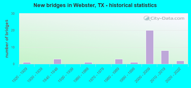
- New bridges - historical statistics
- 11920-1929
- 31940-1949
- 11960-1969
- 31980-1989
- 11990-1999
- 202000-2009
- 82010-2019
- 22020-2022

- Reconstructed bridges - Historical Statistics
- 31960-1969
- 01970-1979
- 11980-1989
- 01990-1999
- 12000-2009


- Bridge Condition - Deck
- 33.3%Very good
- 57.1%Good
- 9.5%Satisfactory

- Bridge Condition - Superstructure
- 28.6%Very good
- 57.1%Good
- 14.3%Satisfactory

- Bridge Condition - Substructure
- 85.7%Good
- 4.8%Satisfactory
- 9.5%Fair

- Bridge Condition - Channel
- 22.2%Very good
- 44.4%Good
- 22.2%Satisfactory
- 11.1%Fair

- Bridge Condition - Culverts
- 28.6%Very good
- 57.1%Good
- 14.3%Satisfactory
Find on map >> Show street view
Structure Number: 121020005102009, Location: 0.80 MI NW OF NASA RD 1 (Lat: 29.546781, Lng: -95.126511), Route carried "on" structure: State highway 3, Year Built: 1925, Year Reconstructed: 1994, Status: Open, Structure Length: 0.67m (2.20ft), Average Daily Traffic: 26,144 (year 2016), Truck Traffic: 6%, Average Future Daily Traffic: 28,190 (year 2033), Features Intersected: COW BAYOU
Minimum Vertical Clearance: 30+ m (98+ ft), Kilometerpoint: 20.551, Lanes on structure: 5, Owner: State Highway Agency, Approaching Roadway Width: 20.7m (67.9ft), Material/Design: Concrete, Design/Construction: Culvert, Number Of Spans In Main Unit: 2, Length of Maximum Span: 3.0m (9.8ft), Curb-To-Curb Width: 21.3m (69.9ft), Out-to-Out Width: 22.0m (72.2ft)
Condition: Channel: Good, Culverts: Good, Operating Rating: 32.7 metric tons, Method Used To Determine Operating Rating: Field evaluation and documented engineering judgment, Inventory Rating: 24.5 metric tons, Method Used To Determine Inventory Rating: Field evaluation and documented engineering judgment, Structural Evaluation: Equal to present minimum criteria, Deck Geometry: Somewhat better than minimum adequacy, Waterway Adequacy: Equal to present minimum criteria, Approach Roadway Alignment: Equal to present desirable criteria, Designated Inspection Frequency: Every 24 months, Inspection Date: November 2020, Deck Structure Type: Concrete Cast-file-Place, Wearing Surface/Protective System: Wearing Surface: Bituminous
Find on map >> Show street view
Structure Number: 121020050003026, Location: 0.65 MI NW OF FM 518 (Lat: 29.512544, Lng: -95.119764), Route carried "on" structure: Interstate 45, Year Built: 1948, Year Reconstructed: 1971, Status: Not yet open, Structure Length: 0.82m (2.69ft), Average Daily Traffic: 133,911 (year 2020), Truck Traffic: 8%, Average Future Daily Traffic: 177,260 (year 2033), Features Intersected: DRAINAGE DITCH
Minimum Vertical Clearance: 30+ m (98+ ft), Kilometerpoint: 0.604, Lanes on structure: 8, Owner: State Highway Agency, Approaching Roadway Width: 43.9m (144.0ft), Skew: 33 degrees, Material/Design: Concrete, Design/Construction: Culvert, Number Of Spans In Main Unit: 2, Length of Maximum Span: 3.0m (9.8ft)
Condition: Channel: Good, Culverts: Satisfactory, Operating Rating: 32.7 metric tons, Method Used To Determine Operating Rating: Load Factor (LF), Inventory Rating: 24.5 metric tons, Method Used To Determine Inventory Rating: Load Factor (LF), Structural Evaluation: Equal to present minimum criteria, Waterway Adequacy: Equal to present minimum criteria, Approach Roadway Alignment: Equal to present desirable criteria, Designated Inspection Frequency: Every 24 months, Inspection Date: November 2020
Find on map >> Show street view
Structure Number: 121020050003027, Location: 1.65 MI SE OF NASA RD 1 (Lat: 29.508042, Lng: -95.117178), Route carried "on" structure: Interstate 45, Year Built: 1948, Year Reconstructed: 1971, Status: Open, Structure Length: 13.78m (45.21ft), Average Daily Traffic: 50,292 (year 2017), Truck Traffic: 4%, Average Future Daily Traffic: 88,630 (year 2033), Design Load: HS 20, Features Intersected: CLEAR CREEK
Minimum Vertical Clearance: 30+ m (98+ ft), Kilometerpoint: 0.002, Lanes on structure: 3, Owner: State Highway Agency, Approaching Roadway Width: 17.7m (58.1ft), Material/Design: Steel, Design/Construction: Stringer/Multi-beam, Number Of Spans In Main Unit: 11, Length of Maximum Span: 15.2m (49.9ft), Curb-To-Curb Width: 17.9m (58.7ft), Out-to-Out Width: 18.7m (61.4ft)
Condition: Deck: Good, Superstructure: Satisfactory, Substructure: Fair, Channel: Satisfactory, Operating Rating: 47.2 metric tons, Method Used To Determine Operating Rating: Load and Resistance Factor (LRFR), Inventory Rating: 28.1 metric tons, Method Used To Determine Inventory Rating: Load and Resistance Factor (LRFR), Structural Evaluation: Somewhat better than minimum adequacy, Deck Geometry: Better than present minimum criteria, Waterway Adequacy: Equal to present minimum criteria, Approach Roadway Alignment: Equal to present desirable criteria, Designated Inspection Frequency: Every 24 months, Underwater Inspection Frequency: Every 36 months, Inspection Date: November 2020, Underwater Inspection Date: Febuary 2021, Deck Structure Type: Concrete Cast-file-Place
Find on map >> Show street view
Structure Number: 121020050003159, Location: 0.4 MI SE OF FM 528 (Lat: 29.525233, Lng: -95.127933), Route carried "on" structure: Ramp Interstate 45, Year Built: 2009, Status: Open, Structure Length: 76.60m (251.31ft), Average Daily Traffic: 60,000 (year 2011), Truck Traffic: 8%, Average Future Daily Traffic: 72,000 (year 2031), Design Load: HS 25 or greater, Features Intersected: IH 45
Minimum Vertical Clearance: 30+ m (98+ ft), Kilometerpoint: 0.002, Lanes on structure: 1, Lanes under structure: 12, Owner: State Highway Agency, Approaching Roadway Width: 7.9m (25.9ft), Material/Design: Steel continuous, Design/Construction: Stringer/Multi-beam, Number Of Spans In Main Unit: 4, Number Of Approach Spans: 10, Length of Maximum Span: 96.6m (316.9ft), Curb-To-Curb Width: 7.9m (25.9ft), Out-to-Out Width: 8.7m (28.5ft)
Condition: Deck: Good, Superstructure: Good, Substructure: Good, Operating Rating: 68.0 metric tons, Method Used To Determine Operating Rating: Assigned ratings based on Load and Resistance Factor Design (LRFD) reported in metric tons, Inventory Rating: 40.8 metric tons, Method Used To Determine Inventory Rating: Assigned ratings based on Load and Resistance Factor Design (LRFD) reported in metric tons, Structural Evaluation: Better than present minimum criteria, Deck Geometry: Equal to present desirable criteria, Underclear: Meets minimum limits, Approach Roadway Alignment: Equal to present desirable criteria, Designated Inspection Frequency: Every 24 months, Inspection Date: November 2020, Deck Structure Type: Concrete Cast-file-Place
Find on map >> Show street view
Structure Number: 12102005000316, Location: 1.4 MI NW OF FM 518 (Lat: 29.520922, Lng: -95.124503), Route carried "on" structure: Interstate 45, Year Built: 2008, Status: Open, Structure Length: 10.06m (33.01ft), Average Daily Traffic: 68,159 (year 2017), Truck Traffic: 8%, Average Future Daily Traffic: 88,630 (year 2033), Design Load: HS 25 or greater, Features Intersected: NASA RD 1 (NASA BYPASS)
Minimum Vertical Clearance: 30+ m (98+ ft), Kilometerpoint: 1.682, Lanes on structure: 3, Lanes under structure: 7, Owner: State Highway Agency, Approaching Roadway Width: 30.5m (100.1ft), Material/Design: Prestressed concrete, Design/Construction: Stringer/Multi-beam, Number Of Spans In Main Unit: 3, Length of Maximum Span: 33.5m (109.9ft), Curb-To-Curb Width: 18.6m (61.0ft), Out-to-Out Width: 31.2m (102.4ft)
Condition: Deck: Good, Superstructure: Good, Substructure: Good, Operating Rating: 68.0 metric tons, Method Used To Determine Operating Rating: Assigned ratings based on Load and Resistance Factor Design (LRFD) reported in metric tons, Inventory Rating: 40.8 metric tons, Method Used To Determine Inventory Rating: Assigned ratings based on Load and Resistance Factor Design (LRFD) reported in metric tons, Structural Evaluation: Better than present minimum criteria, Deck Geometry: Superior to present desirable criteria, Underclear: Somewhat better than minimum adequacy, Approach Roadway Alignment: Equal to present desirable criteria, Designated Inspection Frequency: Every 24 months, Inspection Date: October 2020, Deck Structure Type: Concrete Precast Panels
Find on map >> Show street view
Structure Number: 121020050003161, Location: 1.4 MI NW OF FM 518 (Lat: 29.521500, Lng: -95.125200), Route carried "on" structure: Interstate 45, Year Built: 2008, Status: Open, Structure Length: 10.06m (33.01ft), Average Daily Traffic: 59,076 (year 2017), Truck Traffic: 8%, Average Future Daily Traffic: 88,630 (year 2033), Design Load: HS 25 or greater, Features Intersected: NASA RD 1 (NASA BYPASS)
Minimum Vertical Clearance: 30+ m (98+ ft), Kilometerpoint: 1.682, Lanes on structure: 3, Lanes under structure: 7, Owner: State Highway Agency, Approaching Roadway Width: 30.5m (100.1ft), Material/Design: Prestressed concrete, Design/Construction: Stringer/Multi-beam, Number Of Spans In Main Unit: 3, Length of Maximum Span: 33.5m (109.9ft), Curb-To-Curb Width: 18.5m (60.7ft), Out-to-Out Width: 31.2m (102.4ft)
Condition: Deck: Good, Superstructure: Good, Substructure: Good, Operating Rating: 68.0 metric tons, Method Used To Determine Operating Rating: Assigned ratings based on Load and Resistance Factor Design (LRFD) reported in metric tons, Inventory Rating: 40.8 metric tons, Method Used To Determine Inventory Rating: Assigned ratings based on Load and Resistance Factor Design (LRFD) reported in metric tons, Structural Evaluation: Better than present minimum criteria, Deck Geometry: Superior to present desirable criteria, Underclear: Equal to present minimum criteria, Approach Roadway Alignment: Equal to present desirable criteria, Designated Inspection Frequency: Every 24 months, Inspection Date: October 2020, Deck Structure Type: Concrete Precast Panels
Find on map >> Show street view
Structure Number: 121020050003162, Location: 0.4 MI SE OF FM 528 (Lat: 29.523569, Lng: -95.120747), Route carried "on" structure: State highway 1, Year Built: 2009, Status: Open, Structure Length: 25.36m (83.20ft), Average Daily Traffic: 100,000 (year 2011), Truck Traffic: 10%, Average Future Daily Traffic: 125,000 (year 2031), Design Load: HS 25 or greater, Features Intersected: KOBAYASHI RD
Minimum Vertical Clearance: 30+ m (98+ ft), Kilometerpoint: 0.002, Lanes on structure: 2, Lanes under structure: 6, Owner: State Highway Agency, Approaching Roadway Width: 18.9m (62.0ft), Material/Design: Prestressed concrete, Design/Construction: Stringer/Multi-beam, Number Of Spans In Main Unit: 8, Length of Maximum Span: 31.7m (104.0ft), Curb-To-Curb Width: 15.9m (52.2ft), Out-to-Out Width: 17.3m (56.8ft)
Condition: Deck: Good, Superstructure: Good, Substructure: Good, Operating Rating: 68.0 metric tons, Method Used To Determine Operating Rating: Assigned rating based on Load Factor Design (LFD) reported in metric tons, Inventory Rating: 40.8 metric tons, Method Used To Determine Inventory Rating: Assigned rating based on Load Factor Design (LFD) reported in metric tons, Structural Evaluation: Better than present minimum criteria, Deck Geometry: Superior to present desirable criteria, Underclear: Meets minimum limits, Approach Roadway Alignment: Equal to present desirable criteria, Designated Inspection Frequency: Every 24 months, Inspection Date: November 2020, Deck Structure Type: Concrete Precast Panels
Find on map >> Show street view
Structure Number: 121020050003163, Location: 0.4 MI SE OF FM 528 (Lat: 29.524758, Lng: -95.126608), Route carried "on" structure: Ramp Interstate 45, Year Built: 2009, Status: Open, Structure Length: 60.78m (199.41ft), Average Daily Traffic: 100,000 (year 2011), Truck Traffic: 10%, Average Future Daily Traffic: 125,000 (year 2031), Design Load: HS 25 or greater, Features Intersected: IH 45 NB FRTG
Minimum Vertical Clearance: 30+ m (98+ ft), Kilometerpoint: 0.002, Lanes on structure: 1, Lanes under structure: 6, Owner: State Highway Agency, Approaching Roadway Width: 7.9m (25.9ft), Material/Design: Steel continuous, Design/Construction: Stringer/Multi-beam, Number Of Spans In Main Unit: 7, Number Of Approach Spans: 3, Length of Maximum Span: 85.3m (279.9ft), Curb-To-Curb Width: 7.9m (25.9ft), Out-to-Out Width: 8.7m (28.5ft)
Condition: Deck: Good, Superstructure: Good, Substructure: Good, Operating Rating: 68.0 metric tons, Method Used To Determine Operating Rating: Assigned rating based on Load Factor Design (LFD) reported in metric tons, Inventory Rating: 40.8 metric tons, Method Used To Determine Inventory Rating: Assigned rating based on Load Factor Design (LFD) reported in metric tons, Structural Evaluation: Better than present minimum criteria, Deck Geometry: Equal to present desirable criteria, Underclear: Somewhat better than minimum adequacy, Approach Roadway Alignment: Better than present minimum criteria, Designated Inspection Frequency: Every 24 months, Inspection Date: November 2020, Deck Structure Type: Concrete Cast-file-Place
Find on map >> Show street view
Structure Number: 121020050003338, Location: 1.65 MI SE OF NASA RD 1 (Lat: 29.508122, Lng: -95.116989), Route carried "on" structure: Interstate 45, Year Built: 1948, Year Reconstructed: 1971, Status: Open, Structure Length: 13.78m (45.21ft), Average Daily Traffic: 70,933 (year 2017), Truck Traffic: 4%, Average Future Daily Traffic: 88,630 (year 2033), Design Load: HS 20, Features Intersected: CLEAR CREEK
Minimum Vertical Clearance: 30+ m (98+ ft), Kilometerpoint: 0.002, Lanes on structure: 3, Owner: State Highway Agency, Approaching Roadway Width: 17.7m (58.1ft), Material/Design: Steel, Design/Construction: Stringer/Multi-beam, Number Of Spans In Main Unit: 11, Length of Maximum Span: 15.2m (49.9ft), Curb-To-Curb Width: 17.8m (58.4ft), Out-to-Out Width: 18.6m (61.0ft)
Condition: Deck: Good, Superstructure: Satisfactory, Substructure: Fair, Channel: Satisfactory, Operating Rating: 47.2 metric tons, Method Used To Determine Operating Rating: Load and Resistance Factor (LRFR), Inventory Rating: 28.1 metric tons, Method Used To Determine Inventory Rating: Load and Resistance Factor (LRFR), Structural Evaluation: Somewhat better than minimum adequacy, Deck Geometry: Better than present minimum criteria, Waterway Adequacy: Equal to present minimum criteria, Approach Roadway Alignment: Equal to present desirable criteria, Designated Inspection Frequency: Every 24 months, Underwater Inspection Frequency: Every 24 months, Inspection Date: November 2020, Underwater Inspection Date: Febuary 2021, Deck Structure Type: Concrete Cast-file-Place
Find on map >> Show street view
Structure Number: 121020050003427, Location: 2.00 MI NW OF FM 518 (Lat: 29.528278, Lng: -95.130528), Route carried "on" structure: Interstate 45, Year Built: 2010, Status: Open, Structure Length: 10.24m (33.60ft), Average Daily Traffic: 133,911 (year 2020), Truck Traffic: 8%, Average Future Daily Traffic: 177,260 (year 2033), Design Load: HS 25 or greater, Features Intersected: FM 528 NASA PKWY
Minimum Vertical Clearance: 30+ m (98+ ft), Kilometerpoint: 2.720, Lanes on structure: 11, Lanes under structure: 8, Owner: State Highway Agency, Approaching Roadway Width: 43.9m (144.0ft), Material/Design: Prestressed concrete, Design/Construction: Stringer/Multi-beam, Number Of Spans In Main Unit: 3, Length of Maximum Span: 35.4m (116.1ft), Curb-To-Curb Width: 43.8m (143.7ft), Out-to-Out Width: 69.6m (228.3ft)
Condition: Deck: Good, Superstructure: Good, Substructure: Good, Operating Rating: 68.0 metric tons, Method Used To Determine Operating Rating: Assigned ratings based on Load and Resistance Factor Design (LRFD) reported in metric tons, Inventory Rating: 40.8 metric tons, Method Used To Determine Inventory Rating: Assigned ratings based on Load and Resistance Factor Design (LRFD) reported in metric tons, Structural Evaluation: Better than present minimum criteria, Deck Geometry: Meets minimum limits, Underclear: Equal to present minimum criteria, Approach Roadway Alignment: Equal to present desirable criteria, Designated Inspection Frequency: Every 24 months, Inspection Date: November 2020, Deck Structure Type: Concrete Precast Panels
Find on map >> Show street view
Structure Number: 121020050003443, Location: 6.35 MI SE OF BW 8 (Lat: 29.535731, Lng: -95.137097), Route carried "on" structure: Interstate 45, Year Built: 2016, Status: Open, Structure Length: 0.88m (2.89ft), Average Daily Traffic: 113,652 (year 2020), Truck Traffic: 5%, Average Future Daily Traffic: 143,300 (year 2033), Design Load: HL 93, Features Intersected: STORM SEWER CROSSING
Minimum Vertical Clearance: 30+ m (98+ ft), Kilometerpoint: 0.000, Lanes on structure: 11, Owner: State Highway Agency, Approaching Roadway Width: 70.1m (230.0ft), Skew: 10 degrees, Material/Design: Concrete, Design/Construction: Culvert, Number Of Spans In Main Unit: 3, Length of Maximum Span: 2.4m (7.9ft)
Condition: Channel: Very good, Culverts: Very good, Operating Rating: 54.4 metric tons, Method Used To Determine Operating Rating: Assigned ratings based on Load and Resistance Factor Design (LRFD) reported in metric tons, Inventory Rating: 32.7 metric tons, Method Used To Determine Inventory Rating: Assigned ratings based on Load and Resistance Factor Design (LRFD) reported in metric tons, Structural Evaluation: Equal to present desirable criteria, Waterway Adequacy: Superior to present desirable criteria, Approach Roadway Alignment: Equal to present desirable criteria, Designated Inspection Frequency: Every 24 months, Inspection Date: December 2020
Find on map >> Show street view
Structure Number: 121020050003446, Location: 5.95 MI SE OF BW 8 (Lat: 29.540364, Lng: -95.141133), Route carried "on" structure: Interstate 45, Year Built: 2016, Status: Open, Structure Length: 11.13m (36.52ft), Average Daily Traffic: 68,159 (year 2017), Truck Traffic: 7%, Average Future Daily Traffic: 71,650 (year 2033), Design Load: HL 93, Features Intersected: BAY AREA BLVD
Minimum Vertical Clearance: 30+ m (98+ ft), Kilometerpoint: 0.000, Lanes on structure: 6, Lanes under structure: 10, Owner: State Highway Agency, Approaching Roadway Width: 28.7m (94.2ft), Skew: 1 degrees, Material/Design: Prestressed concrete, Design/Construction: Stringer/Multi-beam, Number Of Spans In Main Unit: 3, Length of Maximum Span: 44.2m (145.0ft), Curb-To-Curb Width: 28.9m (94.8ft), Out-to-Out Width: 29.6m (97.1ft)
Condition: Deck: Very good, Superstructure: Very good, Substructure: Good, Operating Rating: 54.4 metric tons, Method Used To Determine Operating Rating: Assigned ratings based on Load and Resistance Factor Design (LRFD) reported in metric tons, Inventory Rating: 32.7 metric tons, Method Used To Determine Inventory Rating: Assigned ratings based on Load and Resistance Factor Design (LRFD) reported in metric tons, Structural Evaluation: Better than present minimum criteria, Deck Geometry: Better than present minimum criteria, Underclear: Meets minimum limits, Approach Roadway Alignment: Equal to present desirable criteria, Designated Inspection Frequency: Every 24 months, Inspection Date: December 2020, Deck Structure Type: Concrete Precast Panels
Find on map >> Show street view
Structure Number: 121020050003447, Location: 5.95 MI SE OF BW 8 (Lat: 29.540586, Lng: -95.141967), Route carried "on" structure: Interstate 45, Year Built: 2016, Status: Open, Structure Length: 11.13m (36.52ft), Average Daily Traffic: 59,076 (year 2017), Truck Traffic: 7%, Average Future Daily Traffic: 71,650 (year 2033), Design Load: HL 93, Features Intersected: BAY AREA BLVD
Minimum Vertical Clearance: 30+ m (98+ ft), Kilometerpoint: 0.000, Lanes on structure: 6, Lanes under structure: 8, Owner: State Highway Agency, Approaching Roadway Width: 28.7m (94.2ft), Skew: 1 degrees, Material/Design: Prestressed concrete, Design/Construction: Stringer/Multi-beam, Number Of Spans In Main Unit: 3, Length of Maximum Span: 44.2m (145.0ft), Curb-To-Curb Width: 28.9m (94.8ft), Out-to-Out Width: 39.4m (129.3ft)
Condition: Deck: Very good, Superstructure: Very good, Substructure: Good, Operating Rating: 54.4 metric tons, Method Used To Determine Operating Rating: Assigned ratings based on Load and Resistance Factor Design (LRFD) reported in metric tons, Inventory Rating: 32.7 metric tons, Method Used To Determine Inventory Rating: Assigned ratings based on Load and Resistance Factor Design (LRFD) reported in metric tons, Structural Evaluation: Better than present minimum criteria, Deck Geometry: Better than present minimum criteria, Underclear: Meets minimum limits, Approach Roadway Alignment: Equal to present desirable criteria, Designated Inspection Frequency: Every 24 months, Inspection Date: December 2020, Deck Structure Type: Concrete Precast Panels
Find on map >> Show street view
Structure Number: 121020050003465, Location: IH 45 over Clear Creek (Lat: 29.508261, Lng: -95.116717), Route carried "on" structure: ServiceInterstate 45, Year Built: 2020, Status: Open, Structure Length: 62.91m (206.40ft), Average Daily Traffic: 27,400 (year 2020), Truck Traffic: 10%, Average Future Daily Traffic: 37,200 (year 2040), Design Load: HL 93, Features Intersected: Clear Creek
Minimum Vertical Clearance: 30+ m (98+ ft), Kilometerpoint: 1.609, Lanes on structure: 2, Base Highway Network: Yes, Owner: State Highway Agency, Approaching Roadway Width: 16.5m (54.1ft), Material/Design: Prestressed concrete, Design/Construction: Stringer/Multi-beam, Number Of Spans In Main Unit: 15, Number Of Approach Spans: 4, Length of Maximum Span: 38.1m (125.0ft), Curb or Sidewalk Widths: Left: 1.8m (5.9ft), Right: 0.0m, Curb-To-Curb Width: 8.3m (27.2ft), Out-to-Out Width: 11.2m (36.7ft)
Condition: Deck: Very good, Superstructure: Very good, Substructure: Good, Channel: Very good, Operating Rating: 54.4 metric tons, Method Used To Determine Operating Rating: Assigned ratings based on Load and Resistance Factor Design (LRFD) reported in metric tons, Inventory Rating: 32.7 metric tons, Method Used To Determine Inventory Rating: Assigned ratings based on Load and Resistance Factor Design (LRFD) reported in metric tons, Structural Evaluation: Better than present minimum criteria, Deck Geometry: High priority of replacement, Waterway Adequacy: Better than present minimum criteria, Approach Roadway Alignment: Equal to present desirable criteria, Designated Inspection Frequency: Every 24 months, Inspection Date: Febuary 2021, Deck Structure Type: Concrete Precast Panels
Find on map >> Show street view
Structure Number: 121020050003466, Location: IH 45 over Clear Creek (Lat: 29.507908, Lng: -95.117447), Route carried "on" structure: ServiceInterstate 45, Year Built: 2020, Status: Open, Structure Length: 28.35m (93.01ft), Average Daily Traffic: 27,200 (year 2020), Truck Traffic: 10%, Average Future Daily Traffic: 1 (year 1900), Design Load: HL 93, Features Intersected: Clear Creek
Minimum Vertical Clearance: 30+ m (98+ ft), Kilometerpoint: 1.609, Lanes on structure: 2, Base Highway Network: Yes, Owner: State Highway Agency, Approaching Roadway Width: 10.7m (35.1ft), Skew: 9 degrees, Material/Design: Prestressed concrete, Design/Construction: Stringer/Multi-beam, Number Of Spans In Main Unit: 7, Number Of Approach Spans: 1, Length of Maximum Span: 38.1m (125.0ft), Curb or Sidewalk Widths: Left: 0.0m, Right: 1.8m (5.9ft), Curb-To-Curb Width: 11.9m (39.0ft), Out-to-Out Width: 14.9m (48.9ft)
Condition: Deck: Very good, Superstructure: Satisfactory, Substructure: Good, Channel: Very good, Operating Rating: 54.4 metric tons, Method Used To Determine Operating Rating: Assigned ratings based on Load and Resistance Factor Design (LRFD) reported in metric tons, Inventory Rating: 32.7 metric tons, Method Used To Determine Inventory Rating: Assigned ratings based on Load and Resistance Factor Design (LRFD) reported in metric tons, Structural Evaluation: Equal to present minimum criteria, Deck Geometry: Equal to present minimum criteria, Waterway Adequacy: Superior to present desirable criteria, Approach Roadway Alignment: Equal to present desirable criteria, Designated Inspection Frequency: Every 24 months, Inspection Date: Febuary 2021, Deck Structure Type: Concrete Precast Panels
Find on map >> Show street view
Structure Number: 121020098101021, Location: 0.20 MI SW OF IH 45 (Lat: 29.526933, Lng: -95.133344), Route carried "on" structure: State highway 528, Year Built: 1995, Status: Open, Structure Length: 0.88m (2.89ft), Average Daily Traffic: 31,638 (year 2020), Truck Traffic: 4%, Average Future Daily Traffic: 41,880 (year 2033), Design Load: HS 20, Features Intersected: HCFCD DITCH A-111-00-00
Minimum Vertical Clearance: 30+ m (98+ ft), Kilometerpoint: 4.698, Lanes on structure: 6, Owner: State Highway Agency, Approaching Roadway Width: 21.9m (71.9ft), Material/Design: Concrete, Design/Construction: Culvert, Number Of Spans In Main Unit: 3, Length of Maximum Span: 2.4m (7.9ft), Curb or Sidewalk Widths: Left: 2.2m (7.2ft), Right: 2.6m (8.5ft)
Condition: Channel: Good, Culverts: Good, Operating Rating: 39.9 metric tons, Method Used To Determine Operating Rating: Load Factor (LF), Inventory Rating: 23.6 metric tons, Method Used To Determine Inventory Rating: Load Factor (LF), Structural Evaluation: Somewhat better than minimum adequacy, Waterway Adequacy: Equal to present minimum criteria, Approach Roadway Alignment: Equal to present desirable criteria, Designated Inspection Frequency: Every 48 months, Inspection Date: November 2020
Find on map >> Show street view
Structure Number: 121020098101026, Location: 1.4 MI NE OF SH 3 (Lat: 29.546608, Lng: -95.104781), Route carried "on" structure: ServiceState highway 9999, Year Built: 2008, Status: Open, Structure Length: 10.21m (33.50ft), Average Daily Traffic: 6,000 (year 2010), Average Future Daily Traffic: 10,000 (year 2030), Design Load: HS 20, Features Intersected: COW BAYOU, Facility Carried by Structure: NASA 1 WB ACCESS
Minimum Vertical Clearance: 30+ m (98+ ft), Kilometerpoint: 8.156, Lanes on structure: 2, Owner: State Highway Agency, Approaching Roadway Width: 8.5m (27.9ft), Material/Design: Prestressed concrete, Design/Construction: Stringer/Multi-beam, Number Of Spans In Main Unit: 3, Length of Maximum Span: 35.1m (115.2ft), Curb or Sidewalk Widths: Left: 1.6m (5.2ft), Right: 0.0m, Curb-To-Curb Width: 8.4m (27.6ft), Out-to-Out Width: 10.7m (35.1ft)
Condition: Deck: Very good, Superstructure: Good, Substructure: Good, Channel: Good, Operating Rating: 54.4 metric tons, Method Used To Determine Operating Rating: Assigned rating based on Load Factor Design (LFD) reported in metric tons, Inventory Rating: 32.7 metric tons, Method Used To Determine Inventory Rating: Assigned rating based on Load Factor Design (LFD) reported in metric tons, Structural Evaluation: Better than present minimum criteria, Deck Geometry: High priority of corrective action, Waterway Adequacy: Equal to present minimum criteria, Approach Roadway Alignment: Equal to present desirable criteria, Designated Inspection Frequency: Every 24 months, Inspection Date: November 2020, Deck Structure Type: Concrete Precast Panels
Find on map >> Show street view
Structure Number: 121020098101028, Location: 1.3 MI NE OF SH 3 (Lat: 29.546403, Lng: -95.104972), Route carried "on" structure: State highway 9999, Year Built: 2008, Status: Open, Structure Length: 29.81m (97.80ft), Average Daily Traffic: 32,084 (year 2020), Truck Traffic: 3%, Average Future Daily Traffic: 70,350 (year 2033), Design Load: HS 20, Features Intersected: FM 270 & COW BAYOU, Facility Carried by Structure: NASA RD 1
Minimum Vertical Clearance: 30+ m (98+ ft), Kilometerpoint: 7.995, Lanes on structure: 6, Lanes under structure: 9, Owner: State Highway Agency, Approaching Roadway Width: 31.7m (104.0ft), Skew: 39 degrees, Material/Design: Prestressed concrete, Design/Construction: Stringer/Multi-beam, Number Of Spans In Main Unit: 9, Length of Maximum Span: 35.1m (115.2ft), Curb-To-Curb Width: 31.6m (103.7ft), Out-to-Out Width: 32.8m (107.6ft)
Condition: Deck: Very good, Superstructure: Good, Substructure: Good, Channel: Very good, Operating Rating: 54.4 metric tons, Method Used To Determine Operating Rating: Assigned rating based on Load Factor Design (LFD) reported in metric tons, Inventory Rating: 32.7 metric tons, Method Used To Determine Inventory Rating: Assigned rating based on Load Factor Design (LFD) reported in metric tons, Structural Evaluation: Better than present minimum criteria, Deck Geometry: Superior to present desirable criteria, Underclear: Meets minimum limits, Waterway Adequacy: Superior to present desirable criteria, Approach Roadway Alignment: Equal to present desirable criteria, Designated Inspection Frequency: Every 24 months, Inspection Date: November 2020, Deck Structure Type: Concrete Precast Panels
Find on map >> Show street view
Structure Number: 121020098101029, Location: 0.9 MI NE OF SH 3 (Lat: 29.543783, Lng: -95.109542), Route carried "on" structure: State highway 9999, Year Built: 2008, Status: Open, Structure Length: 52.40m (171.92ft), Average Daily Traffic: 32,084 (year 2020), Truck Traffic: 4%, Average Future Daily Traffic: 47,060 (year 2033), Design Load: HS 20, Features Intersected: SARAH DEEL DR, Facility Carried by Structure: NASA RD 1
Minimum Vertical Clearance: 30+ m (98+ ft), Kilometerpoint: 7.351, Lanes on structure: 4, Lanes under structure: 9, Owner: State Highway Agency, Approaching Roadway Width: 23.2m (76.1ft), Material/Design: Prestressed concrete, Design/Construction: Stringer/Multi-beam, Number Of Spans In Main Unit: 13, Number Of Approach Spans: 2, Length of Maximum Span: 36.9m (121.1ft), Curb-To-Curb Width: 23.0m (75.5ft), Out-to-Out Width: 24.4m (80.1ft)
Condition: Deck: Good, Superstructure: Good, Substructure: Good, Operating Rating: 54.4 metric tons, Method Used To Determine Operating Rating: Assigned rating based on Load Factor Design (LFD) reported in metric tons, Inventory Rating: 32.7 metric tons, Method Used To Determine Inventory Rating: Assigned rating based on Load Factor Design (LFD) reported in metric tons, Structural Evaluation: Better than present minimum criteria, Deck Geometry: Superior to present desirable criteria, Underclear: High priority of corrective action, Approach Roadway Alignment: Equal to present desirable criteria, Designated Inspection Frequency: Every 24 months, Critical Feature Inspection Frequency: Every 24 months, Inspection Date: November 2020, Critical Feature Inspection Date: April 2021, Deck Structure Type: Concrete Precast Panels
Find on map >> Show street view
Structure Number: 12102009810103, Location: 1.1 MI E OF IH 45 (Lat: 29.528350, Lng: -95.113225), Route carried "on" structure: State highway 1, Year Built: 2008, Status: Open, Structure Length: 49.50m (162.40ft), Average Daily Traffic: 29,726 (year 2020), Truck Traffic: 3%, Average Future Daily Traffic: 59,090 (year 2033), Design Load: HS 20, Features Intersected: SH 3 & UP RR
Minimum Vertical Clearance: 30+ m (98+ ft), Kilometerpoint: 5.903, Lanes on structure: 4, Lanes under structure: 8, Owner: State Highway Agency, Approaching Roadway Width: 23.2m (76.1ft), Skew: 39 degrees, Material/Design: Prestressed concrete, Design/Construction: Stringer/Multi-beam, Number Of Spans In Main Unit: 13, Number Of Approach Spans: 2, Length of Maximum Span: 36.0m (118.1ft), Curb-To-Curb Width: 23.0m (75.5ft), Out-to-Out Width: 24.4m (80.1ft)
Condition: Deck: Good, Superstructure: Good, Substructure: Good, Operating Rating: 54.4 metric tons, Method Used To Determine Operating Rating: Assigned ratings based on Load and Resistance Factor Design (LRFD) reported in metric tons, Inventory Rating: 32.7 metric tons, Method Used To Determine Inventory Rating: Assigned ratings based on Load and Resistance Factor Design (LRFD) reported in metric tons, Structural Evaluation: Better than present minimum criteria, Deck Geometry: Superior to present desirable criteria, Underclear: High priority of corrective action, Approach Roadway Alignment: Equal to present desirable criteria, Designated Inspection Frequency: Every 24 months, Inspection Date: November 2020, Deck Structure Type: Concrete Precast Panels
Find on map >> Show street view
Structure Number: 121020098101031, Location: 0.30 MI SW OF FM 270 (Lat: 29.543389, Lng: -95.110611), Route carried "on" structure: ServiceState highway 9999, Year Built: 1960, Year Reconstructed: 2008, Status: Open, Structure Length: 0.82m (2.69ft), Average Daily Traffic: 6,000 (year 2010), Average Future Daily Traffic: 9,000 (year 2030), Features Intersected: HL&P DISCHARGE DITCH #1, Facility Carried by Structure: NASA 1 EB ACCESS
Minimum Vertical Clearance: 30+ m (98+ ft), Kilometerpoint: 7.512, Lanes on structure: 6, Owner: State Highway Agency, Approaching Roadway Width: 12.2m (40.0ft), Material/Design: Concrete, Design/Construction: Culvert, Number Of Spans In Main Unit: 3, Length of Maximum Span: 2.1m (6.9ft), Curb or Sidewalk Widths: Left: 0.0m, Right: 1.5m (4.9ft)
Condition: Channel: Fair, Culverts: Good, Operating Rating: 32.7 metric tons, Method Used To Determine Operating Rating: Field evaluation and documented engineering judgment, Inventory Rating: 24.5 metric tons, Method Used To Determine Inventory Rating: Field evaluation and documented engineering judgment, Structural Evaluation: Equal to present minimum criteria, Waterway Adequacy: Superior to present desirable criteria, Approach Roadway Alignment: Equal to present desirable criteria, Designated Inspection Frequency: Every 24 months, Inspection Date: October 2020
Find on map >> Show street view
Structure Number: 121020098101032, Location: 0.30 MI SW OF FM 270 (Lat: 29.542972, Lng: -95.110019), Route carried "on" structure: ServiceState highway 9999, Year Built: 2008, Status: Open, Structure Length: 0.82m (2.69ft), Average Daily Traffic: 6,000 (year 2010), Average Future Daily Traffic: 9,000 (year 2030), Design Load: HS 20, Features Intersected: HL&P DISCHARGE DITCH #2, Facility Carried by Structure: NASA 1 EB ACCESS
Minimum Vertical Clearance: 30+ m (98+ ft), Kilometerpoint: 7.524, Lanes on structure: 3, Owner: State Highway Agency, Approaching Roadway Width: 12.2m (40.0ft), Material/Design: Concrete, Design/Construction: Culvert, Number Of Spans In Main Unit: 3, Length of Maximum Span: 2.1m (6.9ft), Curb or Sidewalk Widths: Left: 0.0m, Right: 1.5m (4.9ft)
Condition: Channel: Good, Culverts: Very good, Operating Rating: 54.4 metric tons, Method Used To Determine Operating Rating: Assigned rating based on Load Factor Design (LFD) reported in metric tons, Inventory Rating: 32.7 metric tons, Method Used To Determine Inventory Rating: Assigned rating based on Load Factor Design (LFD) reported in metric tons, Structural Evaluation: Equal to present desirable criteria, Waterway Adequacy: Superior to present desirable criteria, Approach Roadway Alignment: Equal to present desirable criteria, Designated Inspection Frequency: Every 48 months, Inspection Date: December 2020
Find on map >> Show street view
Structure Number: 121020098101033, Location: 0.45 MI SW OF SH 3 (Lat: 29.525886, Lng: -95.117347), Route carried "on" structure: State highway 9999, Year Built: 2008, Status: Open, Structure Length: 0.88m (2.89ft), Average Daily Traffic: 29,726 (year 2020), Truck Traffic: 3%, Average Future Daily Traffic: 59,090 (year 2033), Design Load: HS 20, Features Intersected: HCFCD DITCH A-109, Facility Carried by Structure: NASA RD 1
Minimum Vertical Clearance: 30+ m (98+ ft), Kilometerpoint: 5.179, Lanes on structure: 5, Owner: State Highway Agency, Approaching Roadway Width: 26.8m (87.9ft), Skew: 30 degrees, Material/Design: Concrete, Design/Construction: Culvert, Number Of Spans In Main Unit: 3, Length of Maximum Span: 2.4m (7.9ft)
Condition: Channel: Good, Culverts: Good, Operating Rating: 54.4 metric tons, Method Used To Determine Operating Rating: Assigned rating based on Load Factor Design (LFD) reported in metric tons, Inventory Rating: 32.7 metric tons, Method Used To Determine Inventory Rating: Assigned rating based on Load Factor Design (LFD) reported in metric tons, Structural Evaluation: Better than present minimum criteria, Waterway Adequacy: Equal to present minimum criteria, Approach Roadway Alignment: Equal to present desirable criteria, Designated Inspection Frequency: Every 48 months, Inspection Date: December 2020
Find on map >> Show street view
Structure Number: 121020AA3265001, Location: 0.1 MI E OF HERCULES (Lat: 29.550322, Lng: -95.111544), Route carried "on" structure: County highway , Year Built: 2011, Status: Open, Structure Length: 3.51m (11.52ft), Average Daily Traffic: 6,000 (year 2009), Average Future Daily Traffic: 7,000 (year 2028), Design Load: HL 93, Features Intersected: COW BAYOU & CANAL, Facility Carried by Structure: EL CAMINO REAL
Minimum Vertical Clearance: 30+ m (98+ ft), Kilometerpoint: 0.002, Lanes on structure: 4, Owner: County Highway Agency, Approaching Roadway Width: 15.9m (52.2ft), Skew: 24 degrees, Material/Design: Prestressed concrete, Design/Construction: Stringer/Multi-beam, Number Of Spans In Main Unit: 1, Length of Maximum Span: 35.1m (115.2ft), Curb or Sidewalk Widths: Left: 1.5m (4.9ft), Right: 1.5m (4.9ft), Curb-To-Curb Width: 15.9m (52.2ft), Out-to-Out Width: 23.5m (77.1ft)
Condition: Deck: Good, Superstructure: Very good, Substructure: Good, Channel: Good, Operating Rating: 54.4 metric tons, Method Used To Determine Operating Rating: Assigned ratings based on Load and Resistance Factor Design (LRFD) reported in metric tons, Inventory Rating: 32.7 metric tons, Method Used To Determine Inventory Rating: Assigned ratings based on Load and Resistance Factor Design (LRFD) reported in metric tons, Structural Evaluation: Better than present minimum criteria, Deck Geometry: Meets minimum limits, Waterway Adequacy: Equal to present desirable criteria, Approach Roadway Alignment: Equal to present desirable criteria, Length Of Structure Improvement: 3.32m (10.89ft), Designated Inspection Frequency: Every 24 months, Inspection Date: August 2021, Bridge Improvement Cost: $169,000, Roadway Improvement Cost: $42,000, Total Project Cost: $211,000, Deck Structure Type: Concrete Precast Panels
Find on map >> Show street view
Structure Number: 121020AA3266001, Location: 0.7 MI NE OF SH 3 (Lat: 29.549961, Lng: -95.115128), Route carried "on" structure: County highway , Year Built: 1983, Status: Open, Structure Length: 6.16m (20.21ft), Average Daily Traffic: 11,240 (year 2009), Average Future Daily Traffic: 12,000 (year 2028), Features Intersected: HCFCD DITCH, Facility Carried by Structure: MEDICAL CTR BLVD
Minimum Vertical Clearance: 30+ m (98+ ft), Kilometerpoint: 1.127, Lanes on structure: 4, Owner: County Highway Agency, Approaching Roadway Width: 12.2m (40.0ft), Skew: 3 degrees, Material/Design: Prestressed concrete, Design/Construction: Box Beam or Girders - Multiple, Number Of Spans In Main Unit: 5, Length of Maximum Span: 12.2m (40.0ft), Curb or Sidewalk Widths: Left: 0.0m, Right: 1.3m (4.3ft), Curb-To-Curb Width: 12.2m (40.0ft), Out-to-Out Width: 14.4m (47.2ft)
Condition: Deck: Satisfactory, Superstructure: Good, Substructure: Satisfactory, Channel: Fair, Operating Rating: 32.7 metric tons, Method Used To Determine Operating Rating: Field evaluation and documented engineering judgment, Inventory Rating: 24.5 metric tons, Method Used To Determine Inventory Rating: Field evaluation and documented engineering judgment, Structural Evaluation: Equal to present minimum criteria, Deck Geometry: High priority of replacement, Waterway Adequacy: Equal to present minimum criteria, Approach Roadway Alignment: Equal to present desirable criteria, Length Of Structure Improvement: 6.16m (20.21ft), Designated Inspection Frequency: Every 24 months, Inspection Date: August 2021, Bridge Improvement Cost: $16,000, Roadway Improvement Cost: $4,000, Total Project Cost: $20,000, Deck Structure Type: Concrete Cast-file-Place
Find on map >> Show street view
Structure Number: 121020AA3268001, Location: .1MI E OF FEATHER CRAFT (Lat: 29.550836, Lng: -95.120242), Route carried "on" structure: County highway , Year Built: 1983, Status: Open, Structure Length: 2.90m (9.51ft), Average Daily Traffic: 7,510 (year 2009), Average Future Daily Traffic: 8,250 (year 2028), Features Intersected: HCFCD DITCH, Facility Carried by Structure: GEMINI AVE
Minimum Vertical Clearance: 30+ m (98+ ft), Kilometerpoint: 0.402, Lanes on structure: 4, Owner: County Highway Agency, Approaching Roadway Width: 14.6m (47.9ft), Material/Design: Prestressed concrete, Design/Construction: Box Beam or Girders - Multiple, Number Of Spans In Main Unit: 3, Length of Maximum Span: 9.8m (32.2ft), Curb or Sidewalk Widths: Left: 1.5m (4.9ft), Right: 1.5m (4.9ft), Curb-To-Curb Width: 14.6m (47.9ft), Out-to-Out Width: 18.3m (60.0ft)
Condition: Deck: Good, Superstructure: Very good, Substructure: Good, Channel: Good, Operating Rating: 54.4 metric tons, Method Used To Determine Operating Rating: Assigned rating based on Load Factor Design (LFD) reported in metric tons, Inventory Rating: 32.7 metric tons, Method Used To Determine Inventory Rating: Assigned rating based on Load Factor Design (LFD) reported in metric tons, Structural Evaluation: Better than present minimum criteria, Deck Geometry: High priority of replacement, Waterway Adequacy: Better than present minimum criteria, Approach Roadway Alignment: Equal to present desirable criteria, Length Of Structure Improvement: 2.90m (9.51ft), Designated Inspection Frequency: Every 24 months, Inspection Date: August 2021, Bridge Improvement Cost: $9,000, Roadway Improvement Cost: $2,000, Total Project Cost: $11,000, Deck Structure Type: Concrete Cast-file-Place
Find on map >> Show street view
Structure Number: 121020DD0023001, Location: 0.25 MI SE OF BAY AREA (Lat: 29.548775, Lng: -95.121431), Route carried "on" structure: City street , Year Built: 1986, Status: Open, Structure Length: 3.20m (10.50ft), Average Daily Traffic: 4,250 (year 2009), Average Future Daily Traffic: 5,000 (year 2026), Features Intersected: HCFCD DITCH, Facility Carried by Structure: FEATHER CRAFT LN
Minimum Vertical Clearance: 30+ m (98+ ft), Kilometerpoint: 0.161, Lanes on structure: 2, Owner: Town or Township Highway Agency, Approaching Roadway Width: 12.2m (40.0ft), Material/Design: Prestressed concrete, Design/Construction: Box Beam or Girders - Multiple, Number Of Spans In Main Unit: 3, Length of Maximum Span: 10.7m (35.1ft), Curb or Sidewalk Widths: Left: 1.8m (5.9ft), Right: 1.8m (5.9ft), Curb-To-Curb Width: 12.2m (40.0ft), Out-to-Out Width: 16.5m (54.1ft)
Condition: Deck: Satisfactory, Superstructure: Very good, Substructure: Good, Channel: Satisfactory, Operating Rating: 32.7 metric tons, Method Used To Determine Operating Rating: Field evaluation and documented engineering judgment, Inventory Rating: 24.5 metric tons, Method Used To Determine Inventory Rating: Field evaluation and documented engineering judgment, Structural Evaluation: Equal to present minimum criteria, Deck Geometry: Equal to present minimum criteria, Waterway Adequacy: Better than present minimum criteria, Approach Roadway Alignment: Equal to present desirable criteria, Designated Inspection Frequency: Every 24 months, Inspection Date: November 2021, Deck Structure Type: Concrete Cast-file-Place
Find on map >> Show street view
Structure Number: 121020DD0090001, Location: 0.1 MI NE OF WATER ST (Lat: 29.541556, Lng: -95.108944), Route carried "on" structure: City street , Year Built: 2005, Status: Open, Structure Length: 2.29m (7.51ft), Average Daily Traffic: 750 (year 2009), Average Future Daily Traffic: 1,000 (year 2026), Design Load: HS 20, Features Intersected: HL&P COOLING WATER CANAL, Facility Carried by Structure: KNIGHTS BRIDGE LN
Minimum Vertical Clearance: 30+ m (98+ ft), Kilometerpoint: 0.161, Lanes on structure: 2, Owner: Town or Township Highway Agency, Approaching Roadway Width: 8.2m (26.9ft), Material/Design: Prestressed concrete, Design/Construction: Stringer/Multi-beam, Number Of Spans In Main Unit: 1, Length of Maximum Span: 22.9m (75.1ft), Curb or Sidewalk Widths: Left: 1.7m (5.6ft), Right: 1.7m (5.6ft), Curb-To-Curb Width: 8.2m (26.9ft), Out-to-Out Width: 12.2m (40.0ft)
Condition: Deck: Very good, Superstructure: Good, Substructure: Good, Channel: Satisfactory, Operating Rating: 54.4 metric tons, Method Used To Determine Operating Rating: Assigned rating based on Load Factor Design (LFD) reported in metric tons, Inventory Rating: 32.7 metric tons, Method Used To Determine Inventory Rating: Assigned rating based on Load Factor Design (LFD) reported in metric tons, Structural Evaluation: Better than present minimum criteria, Deck Geometry: Somewhat better than minimum adequacy, Waterway Adequacy: Better than present minimum criteria, Approach Roadway Alignment: Equal to present desirable criteria, Designated Inspection Frequency: Every 24 months, Inspection Date: August 2021, Deck Structure Type: Concrete Precast Panels
Find on map >> Show street view
Structure Number: 121020050003159, Location: 0.4 MI SE OF FM 528 (Lat: 29.522633, Lng: -95.125953), Route carried "under" structure: Interstate 45, Year Built: 2009, Structure Length: 0. m, Average Daily Traffic: 100,000 (year 2011), Truck Traffic: 10%, Features Intersected: IH 45
Minimum Vertical Clearance: 15.11m (49.57ft), Kilometerpoint: 0.002, Lanes on structure: 1, Lanes under structure: 12, Material/Design: Steel continuous, Design/Construction: Stringer/Multi-beam, Length of Maximum Span: 96.6m (316.9ft)
Find on map >> Show street view
Structure Number: 12102005000316, Location: 1.4 MI NW OF FM 518 (Lat: 29.528739, Lng: -95.130603), Route carried "under" structure: State highway 9999, Year Built: 2008, Structure Length: 0. m, Average Daily Traffic: 42,210 (year 2013), Truck Traffic: 3%, Features Intersected: NASA RD 1 (NASA BYPASS), Facility Carried by Structure: IH 45 NB
Minimum Vertical Clearance: 5.31m (17.42ft), Kilometerpoint: 4.294, Lanes on structure: 3, Lanes under structure: 7, Material/Design: Prestressed concrete, Design/Construction: Stringer/Multi-beam, Length of Maximum Span: 33.5m (109.9ft)
Find on map >> Show street view
Structure Number: 121020050003161, Location: 1.4 MI NW OF FM 518 (Lat: 29.528625, Lng: -95.130756), Route carried "under" structure: State highway 9999, Year Built: 2008, Structure Length: 0. m, Average Daily Traffic: 42,210 (year 2013), Truck Traffic: 3%, Features Intersected: NASA RD 1 (NASA BYPASS), Facility Carried by Structure: IH 45 SB
Minimum Vertical Clearance: 5.31m (17.42ft), Kilometerpoint: 4.294, Lanes on structure: 3, Lanes under structure: 7, Material/Design: Prestressed concrete, Design/Construction: Stringer/Multi-beam, Length of Maximum Span: 33.5m (109.9ft)
Find on map >> Show street view
Structure Number: 121020050003162, Location: 0.4 MI SE OF FM 528 (Lat: 29.523569, Lng: -95.120747), Route carried "under" structure: City street , Year Built: 2009, Structure Length: 0. m, Average Daily Traffic: 3,000 (year 2011), Features Intersected: KOBAYASHI RD, Facility Carried by Structure: NASA RD 1
Minimum Vertical Clearance: 5.66m (18.57ft), Lanes on structure: 2, Lanes under structure: 6, Material/Design: Prestressed concrete, Design/Construction: Stringer/Multi-beam, Length of Maximum Span: 31.7m (104.0ft)
Find on map >> Show street view
Structure Number: 121020050003163, Location: 0.4 MI SE OF FM 528 (Lat: 29.522428, Lng: -95.125611), Route carried "under" structure: ServiceInterstate 45, Year Built: 2009, Structure Length: 0. m, Average Daily Traffic: 6,700 (year 2013), Truck Traffic: 7%, Features Intersected: IH 45 NB FRTG
Minimum Vertical Clearance: 6.48m (21.26ft), Kilometerpoint: 0.000, Lanes on structure: 1, Lanes under structure: 6, Material/Design: Steel continuous, Design/Construction: Stringer/Multi-beam, Length of Maximum Span: 85.3m (279.9ft)
Find on map >> Show street view
Structure Number: 121020050003427, Location: 2.00 MI NW OF FM 518 (Lat: 29.528278, Lng: -95.130528), Route carried "under" structure: State highway 528, Year Built: 2010, Structure Length: 0. m, Average Daily Traffic: 29,910 (year 2013), Truck Traffic: 4%, Features Intersected: FM 528 NASA PKWY, Facility Carried by Structure: IH 45
Minimum Vertical Clearance: 5.11m (16.77ft), Kilometerpoint: 0.002, Lanes on structure: 8, Lanes under structure: 8, Material/Design: Prestressed concrete, Design/Construction: Stringer/Multi-beam, Length of Maximum Span: 35.4m (116.1ft)
Find on map >> Show street view
Structure Number: 121020050003446, Location: 5.95 MI SE OF BW 8 (Lat: 29.540281, Lng: -95.141408), Route carried "under" structure: City street , Year Built: 2016, Structure Length: 0. m, Average Daily Traffic: 31,340 (year 2016), Features Intersected: BAY AREA BLVD, Facility Carried by Structure: IH 45 NB
Minimum Vertical Clearance: 5.03m (16.50ft), Kilometerpoint: 0.805, Lanes on structure: 6, Lanes under structure: 10, Material/Design: Prestressed concrete, Design/Construction: Stringer/Multi-beam, Length of Maximum Span: 44.2m (145.0ft)
Find on map >> Show street view
Structure Number: 121020050003447, Location: 5.95 MI SE OF BW 8 (Lat: 29.540586, Lng: -95.141967), Route carried "under" structure: City street , Year Built: 2016, Structure Length: 0. m, Average Daily Traffic: 31,340 (year 2016), Features Intersected: BAY AREA BLVD, Facility Carried by Structure: IH 45 SB
Minimum Vertical Clearance: 5.39m (17.68ft), Kilometerpoint: 0.805, Lanes on structure: 6, Lanes under structure: 8, Material/Design: Prestressed concrete, Design/Construction: Stringer/Multi-beam, Length of Maximum Span: 44.2m (145.0ft)
Find on map >> Show street view
Structure Number: 121020098101028, Location: 1.3 MI NE OF SH 3 (Lat: 29.546403, Lng: -95.104972), Route carried "under" structure: State highway 270, Year Built: 2008, Structure Length: 0. m, Average Daily Traffic: 23,000 (year 2010), Truck Traffic: 4%, Features Intersected: FM 270 & COW BAYOU, Facility Carried by Structure: NASA RD 1
Minimum Vertical Clearance: 5.61m (18.41ft), Kilometerpoint: 4.579, Lanes on structure: 6, Lanes under structure: 9, Material/Design: Prestressed concrete, Design/Construction: Stringer/Multi-beam, Length of Maximum Span: 35.1m (115.2ft)
Find on map >> Show street view
Structure Number: 121020098101029, Location: 0.9 MI NE OF SH 3 (Lat: 29.543783, Lng: -95.109542), Route carried "under" structure: ServiceState highway 1, Year Built: 2008, Structure Length: 0. m, Average Daily Traffic: 6,000 (year 2010), Truck Traffic: 3%, Features Intersected: SARAH DEEL DR
Minimum Vertical Clearance: 5.49m (18.01ft), Kilometerpoint: 7.351, Lanes on structure: 4, Lanes under structure: 9, Material/Design: Prestressed concrete, Design/Construction: Stringer/Multi-beam, Length of Maximum Span: 36.9m (121.1ft)
Find on map >> Show street view
Structure Number: 12102009810103, Location: 1.1 MI E OF IH 45 (Lat: 29.528350, Lng: -95.113225), Route carried "under" structure: State highway 3, Year Built: 2008, Structure Length: 0. m, Average Daily Traffic: 7,500 (year 2010), Truck Traffic: 9%, Features Intersected: SH 3 & UP RR, Facility Carried by Structure: NASA RD 1
Minimum Vertical Clearance: 7.93m (26.02ft), Kilometerpoint: 21.836, Lanes on structure: 4, Lanes under structure: 8, Material/Design: Prestressed concrete, Design/Construction: Stringer/Multi-beam, Length of Maximum Span: 36.0m (118.1ft)