Bridge Statistics for Weldon, North Carolina (NC)
Condition, Traffic, Stress, Structural Evaluation, Project Costs
- National Bridge Inventory (NBI) Statistics
- 13Number of bridges
- 171ft / 52.1mTotal length
- 158,290Total average daily traffic
- 32,207Total average daily truck traffic
- National Bridge Inventory (NBI) Registered Bridges for Weldon
- No street view available for this location
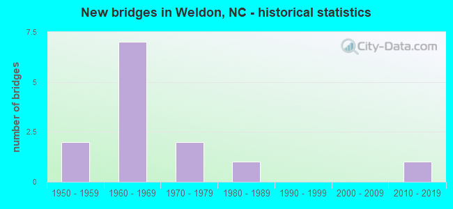
- New bridges - historical statistics
- 21950-1959
- 71960-1969
- 21970-1979
- 11980-1989
- 12010-2019


- Bridge Condition - Deck
- 14.3%Excellent
- 14.3%Good
- 42.9%Satisfactory
- 28.6%Fair

- Bridge Condition - Superstructure
- 14.3%Excellent
- 14.3%Very good
- 28.6%Satisfactory
- 42.9%Fair

- Bridge Condition - Substructure
- 14.3%Very good
- 28.6%Satisfactory
- 57.1%Fair

- Bridge Condition - Channel
- 14.3%Very good
- 28.6%Good
- 14.3%Satisfactory
- 42.9%Fair
Find on map >> Show street view
Structure Number: 830039, Location: 1.3 MI E JCT I95 (Lat: 36.430647, Lng: -77.607614), Route carried "on" structure: US 158, Year Built: 1954, Status: Open, Structure Length: 1.37m (4.49ft), Average Daily Traffic: 13,000 (year 2018), Truck Traffic: 12%, Average Future Daily Traffic: 26,000 (year 2040), Design Load: HS 20+Mod, Features Intersected: CHOCKOYOTTE CREEK
Minimum Vertical Clearance: 30+ m (98+ ft), Kilometerpoint: 0.000, Lanes on structure: 4, Base Highway Network: Yes (Inventory Route: 2, Subroute: 58), Owner: State Highway Agency, Approaching Roadway Width: 14.6m (47.9ft), Material/Design: Concrete continuous, Design/Construction: Culvert, Number Of Spans In Main Unit: 4, Length of Maximum Span: 3.0m (9.8ft)
Condition: Channel: Good, Culverts: Fair, Operating Rating: 41.7 metric tons, Method Used To Determine Operating Rating: Field evaluation and documented engineering judgment, Inventory Rating: 32.6 metric tons, Method Used To Determine Inventory Rating: Field evaluation and documented engineering judgment, Structural Evaluation: Somewhat better than minimum adequacy, Waterway Adequacy: Better than present minimum criteria, Approach Roadway Alignment: Equal to present desirable criteria, Designated Inspection Frequency: Every 24 months, Underwater Inspection Frequency: Every 60 months, Inspection Date: Febuary 2021, Underwater Inspection Date: Febuary 2021
Find on map >> Show street view
Structure Number: 83005, Location: 1.0 MI S JCT SR1600 (Lat: 36.352967, Lng: -77.643400), Route carried "on" structure: State highway 903, Year Built: 1970, Status: Open, Structure Length: 3.20m (10.50ft), Average Daily Traffic: 1,600 (year 2018), Truck Traffic: 7%, Average Future Daily Traffic: 3,200 (year 2025), Design Load: HS 15, Features Intersected: QUANKEY CREEK
Minimum Vertical Clearance: 30+ m (98+ ft), Kilometerpoint: 0.000, Lanes on structure: 2, Owner: State Highway Agency, Approaching Roadway Width: 8.5m (27.9ft), Material/Design: Prestressed concrete, Design/Construction: Slab, Number Of Spans In Main Unit: 3, Length of Maximum Span: 10.3m (33.8ft), Curb-To-Curb Width: 8.9m (29.2ft), Out-to-Out Width: 9.2m (30.2ft)
Condition: Deck: Fair, Superstructure: Fair, Substructure: Fair, Channel: Good, Operating Rating: 45.3 metric tons, Method Used To Determine Operating Rating: Load Factor (LF), Inventory Rating: 27.2 metric tons, Method Used To Determine Inventory Rating: Load Factor (LF), Structural Evaluation: Somewhat better than minimum adequacy, Deck Geometry: Somewhat better than minimum adequacy, Waterway Adequacy: Equal to present minimum criteria, Approach Roadway Alignment: Equal to present desirable criteria, Designated Inspection Frequency: Every 24 months, Inspection Date: July 2021, Deck Structure Type: Concrete Precast Panels, Wearing Surface/Protective System: Wearing Surface: Bituminous
Find on map >> Show street view
Structure Number: 830063, Location: 0.4 MI.E. OF JCT.SR1150 (Lat: 36.430128, Lng: -77.591219), Route carried "on" structure: Alternate Interstate 158, Year Built: 1978, Status: Open, Structure Length: 23.16m (75.98ft), Average Daily Traffic: 9,300 (year 2018), Truck Traffic: 12%, Average Future Daily Traffic: 18,600 (year 2040), Design Load: HS 20+Mod, Features Intersected: ROANOKE RIVER
Minimum Vertical Clearance: 30+ m (98+ ft), Kilometerpoint: 0.000, Lanes on structure: 2, Base Highway Network: Yes (Inventory Route: 2, Subroute: 58), Owner: State Highway Agency, Approaching Roadway Width: 13.7m (44.9ft), Material/Design: Steel continuous, Design/Construction: Stringer/Multi-beam, Number Of Spans In Main Unit: 3, Number Of Approach Spans: 2, Length of Maximum Span: 54.8m (179.8ft), Curb-To-Curb Width: 13.4m (44.0ft), Out-to-Out Width: 14.2m (46.6ft)
Condition: Deck: Fair, Superstructure: Satisfactory, Substructure: Fair, Channel: Fair, Operating Rating: 89.8 metric tons, Method Used To Determine Operating Rating: Load Factor (LF), Inventory Rating: 59.8 metric tons, Method Used To Determine Inventory Rating: Load Factor (LF), Structural Evaluation: Somewhat better than minimum adequacy, Deck Geometry: Equal to present minimum criteria, Waterway Adequacy: Equal to present desirable criteria, Approach Roadway Alignment: Equal to present desirable criteria, Designated Inspection Frequency: Every 24 months, Underwater Inspection Frequency: Every 60 months, Inspection Date: January 2021, Underwater Inspection Date: August 2021, Deck Structure Type: Concrete Cast-file-Place, Wearing Surface/Protective System: Wearing Surface: Monolithic Concrete
Find on map >> Show street view
Structure Number: 830083, Location: 0.4 MI. E. JCT. NC903 (Lat: 36.362814, Lng: -77.656619), Route carried "on" structure: State highway 1600, Year Built: 2019, Status: Open, Structure Length: 2.49m (8.17ft), Average Daily Traffic: 1,600 (year 2015), Truck Traffic: 6%, Average Future Daily Traffic: 3,200 (year 2040), Design Load: HL 93, Features Intersected: QUANKEY CREEK
Minimum Vertical Clearance: 30+ m (98+ ft), Kilometerpoint: 0.000, Lanes on structure: 2, Owner: State Highway Agency, Approaching Roadway Width: 9.4m (30.8ft), Material/Design: Prestressed concrete, Design/Construction: Slab, Number Of Spans In Main Unit: 2, Length of Maximum Span: 16.4m (53.8ft), Curb-To-Curb Width: 9.1m (29.9ft), Out-to-Out Width: 10.0m (32.8ft)
Condition: Deck: Excellent, Superstructure: Excellent, Substructure: Very good, Channel: Very good, Operating Rating: 48.9 metric tons, Method Used To Determine Operating Rating: Load and Resistance Factor (LRFR), Inventory Rating: 38.1 metric tons, Method Used To Determine Inventory Rating: Load and Resistance Factor (LRFR), Structural Evaluation: Equal to present desirable criteria, Deck Geometry: Somewhat better than minimum adequacy, Waterway Adequacy: Better than present minimum criteria, Approach Roadway Alignment: Equal to present desirable criteria, Designated Inspection Frequency: Every 24 months, Inspection Date: September 2021, Deck Structure Type: Concrete Precast Panels, Wearing Surface/Protective System: Wearing Surface: Bituminous, Deck Protection: Epoxy Coated Reinforcing
Find on map >> Show street view
Structure Number: 830084, Location: 1.5 MI. N. JCT. NC903 (Lat: 36.377231, Lng: -77.648986), Route carried "on" structure: State highway 1600, Year Built: 1953, Year Reconstructed: 1974, Status: Posted for load, Structure Length: 1.09m (3.58ft), Average Daily Traffic: 1,900 (year 2016), Truck Traffic: 6%, Average Future Daily Traffic: 3,800 (year 2040), Features Intersected: LITTLE QUANKEY CREEK
Minimum Vertical Clearance: 30+ m (98+ ft), Kilometerpoint: 0.000, Lanes on structure: 2, Owner: State Highway Agency, Approaching Roadway Width: 6.7m (22.0ft), Material/Design: Steel, Design/Construction: Stringer/Multi-beam, Number Of Spans In Main Unit: 2, Length of Maximum Span: 5.4m (17.7ft), Curb-To-Curb Width: 7.2m (23.6ft), Out-to-Out Width: 7.3m (24.0ft)
Condition: Deck: Satisfactory, Superstructure: Fair, Substructure: Fair, Channel: Satisfactory, Operating Rating: 38.1 metric tons, Method Used To Determine Operating Rating: Allowable Stress (AS), Inventory Rating: 19.9 metric tons, Method Used To Determine Inventory Rating: Allowable Stress (AS), Structural Evaluation: Somewhat better than minimum adequacy, Deck Geometry: High priority of corrective action, Waterway Adequacy: Equal to present minimum criteria, Approach Roadway Alignment: Equal to present desirable criteria, Bridge Posting: Required (Relationship of Operating Rating to Maximum Legal Load: 10.0 - 19.9% below), Designated Inspection Frequency: Every 24 months, Underwater Inspection Frequency: Every 60 months, Inspection Date: June 2021, Underwater Inspection Date: June 2018, Deck Structure Type: Corrugated Steel, Wearing Surface/Protective System: Wearing Surface: Bituminous
Find on map >> Show street view
Structure Number: 830105, Location: 1.1 MI. E. JCT. SR1615 (Lat: 36.353819, Lng: -77.679692), Route carried "on" structure: State highway 1600, Year Built: 1964, Status: Open, Structure Length: 8.80m (28.87ft), Average Daily Traffic: 690 (year 2015), Truck Traffic: 6%, Average Future Daily Traffic: 1,380 (year 2040), Design Load: HS 20+Mod, Features Intersected: I95
Minimum Vertical Clearance: 30+ m (98+ ft), Kilometerpoint: 0.000, Lanes on structure: 2, Lanes under structure: 4, Owner: State Highway Agency, Approaching Roadway Width: 6.7m (22.0ft), Skew: 2 degrees, Material/Design: Steel, Design/Construction: Stringer/Multi-beam, Number Of Spans In Main Unit: 4, Length of Maximum Span: 22.8m (74.8ft), Curb or Sidewalk Widths: Left: 0.3m (1.0ft), Right: 0.3m (1.0ft), Curb-To-Curb Width: 7.3m (24.0ft), Out-to-Out Width: 8.6m (28.2ft)
Condition: Deck: Satisfactory, Superstructure: Fair, Substructure: Satisfactory, Operating Rating: 77.1 metric tons, Method Used To Determine Operating Rating: Load Factor (LF), Inventory Rating: 46.2 metric tons, Method Used To Determine Inventory Rating: Load Factor (LF), Structural Evaluation: Somewhat better than minimum adequacy, Deck Geometry: Meets minimum limits, Underclear: High priority of corrective action, Approach Roadway Alignment: Equal to present desirable criteria, Designated Inspection Frequency: Every 24 months, Inspection Date: August 2021, Deck Structure Type: Concrete Cast-file-Place, Wearing Surface/Protective System: Wearing Surface: Latex Concrete
Find on map >> Show street view
Structure Number: 830107, Location: 0.8 MI.N JCT SR1600 (Lat: 36.363989, Lng: -77.672669), Route carried "on" structure: State highway 903, Year Built: 1964, Status: Open, Structure Length: 7.68m (25.20ft), Average Daily Traffic: 2,100 (year 2018), Truck Traffic: 7%, Average Future Daily Traffic: 4,200 (year 2040), Design Load: HS 20+Mod, Features Intersected: I95
Minimum Vertical Clearance: 30+ m (98+ ft), Kilometerpoint: 0.000, Lanes on structure: 2, Lanes under structure: 4, Owner: State Highway Agency, Approaching Roadway Width: 8.2m (26.9ft), Material/Design: Steel, Design/Construction: Stringer/Multi-beam, Number Of Spans In Main Unit: 4, Length of Maximum Span: 19.8m (65.0ft), Curb or Sidewalk Widths: Left: 0.4m (1.3ft), Right: 0.4m (1.3ft), Curb-To-Curb Width: 8.5m (27.9ft), Out-to-Out Width: 10.1m (33.1ft)
Condition: Deck: Satisfactory, Superstructure: Satisfactory, Substructure: Satisfactory, Operating Rating: 76.2 metric tons, Method Used To Determine Operating Rating: Load Factor (LF), Inventory Rating: 45.3 metric tons, Method Used To Determine Inventory Rating: Load Factor (LF), Structural Evaluation: Equal to present minimum criteria, Deck Geometry: Meets minimum limits, Underclear: High priority of corrective action, Approach Roadway Alignment: Equal to present desirable criteria, Designated Inspection Frequency: Every 24 months, Inspection Date: August 2021, Deck Structure Type: Concrete Cast-file-Place, Wearing Surface/Protective System: Wearing Surface: Latex Concrete
Find on map >> Show street view
Structure Number: 830108, Location: 0.6 MI N JCT NC903 (Lat: 36.370158, Lng: -77.668342), Route carried "on" structure: Interstate 95, Year Built: 1960, Status: Open, Structure Length: 1.28m (4.20ft), Average Daily Traffic: 45,500 (year 2019), Truck Traffic: 23%, Average Future Daily Traffic: 89,000 (year 2040), Design Load: HS 20+Mod, Features Intersected: QUANKEY CREEK
Minimum Vertical Clearance: 30+ m (98+ ft), Kilometerpoint: 51.237, Lanes on structure: 4, Base Highway Network: Yes (Inventory Route: 1, Subroute: 95), Owner: State Highway Agency, Approaching Roadway Width: 25.6m (84.0ft), Material/Design: Concrete continuous, Design/Construction: Culvert, Number Of Spans In Main Unit: 4, Length of Maximum Span: 3.0m (9.8ft)
Condition: Channel: Fair, Culverts: Fair, Operating Rating: 41.7 metric tons, Method Used To Determine Operating Rating: Load Factor (LF), Inventory Rating: 32.6 metric tons, Method Used To Determine Inventory Rating: Load Factor (LF), Structural Evaluation: Somewhat better than minimum adequacy, Waterway Adequacy: Better than present minimum criteria, Approach Roadway Alignment: Equal to present desirable criteria, Designated Inspection Frequency: Every 24 months, Underwater Inspection Frequency: Every 60 months, Inspection Date: June 2021, Underwater Inspection Date: June 2021
Find on map >> Show street view
Structure Number: 830184, Location: 0.1 MI. N. JCT. SR1709 (Lat: 36.418886, Lng: -77.613353), Route carried "on" structure: State highway 1641, Year Built: 1989, Status: Open, Structure Length: 3.04m (9.97ft), Average Daily Traffic: 2,600 (year 2015), Truck Traffic: 6%, Average Future Daily Traffic: 5,200 (year 2040), Design Load: HS 20+Mod, Features Intersected: CHOCKOYOTTE CREEK
Minimum Vertical Clearance: 30+ m (98+ ft), Kilometerpoint: 0.000, Lanes on structure: 2, Owner: State Highway Agency, Approaching Roadway Width: 9.7m (31.8ft), Skew: 3 degrees, Material/Design: Steel, Design/Construction: Stringer/Multi-beam, Number Of Spans In Main Unit: 2, Length of Maximum Span: 14.3m (46.9ft), Curb-To-Curb Width: 12.1m (39.7ft), Out-to-Out Width: 13.1m (43.0ft)
Condition: Deck: Good, Superstructure: Very good, Substructure: Fair, Channel: Fair, Operating Rating: 78.0 metric tons, Method Used To Determine Operating Rating: Load Factor (LF), Inventory Rating: 46.2 metric tons, Method Used To Determine Inventory Rating: Load Factor (LF), Structural Evaluation: Somewhat better than minimum adequacy, Deck Geometry: Somewhat better than minimum adequacy, Waterway Adequacy: Equal to present minimum criteria, Approach Roadway Alignment: Better than present minimum criteria, Designated Inspection Frequency: Every 24 months, Underwater Inspection Frequency: Every 60 months, Inspection Date: July 2021, Underwater Inspection Date: August 2021, Deck Structure Type: Concrete Cast-file-Place, Wearing Surface/Protective System: Wearing Surface: Monolithic Concrete, Deck Protection: Epoxy Coated Reinforcing
Find on map >> Show street view
Structure Number: 830105, Location: 1.1 MI. E. JCT. SR1615 (Lat: 36.353819, Lng: -77.679692), Route carried "under" structure: Interstate 95, Year Built: 1964, Structure Length: 0. m, Average Daily Traffic: 20,000 (year 2018), Truck Traffic: 23%, Features Intersected: SR1600
Minimum Vertical Clearance: 5.03m (16.50ft), Kilometerpoint: 50.749, Lanes on structure: 2, Lanes under structure: 2, Material/Design: Steel, Design/Construction: Stringer/Multi-beam, Length of Maximum Span: 22.8m (74.8ft)
Find on map >> Show street view
Structure Number: 830105, Location: 1.1 MI. E. JCT. SR1615 (Lat: 36.353819, Lng: -77.679692), Route carried "under" structure: Interstate 95, Year Built: 1964, Structure Length: 0. m, Average Daily Traffic: 20,000 (year 2018), Truck Traffic: 23%, Features Intersected: SR1600
Minimum Vertical Clearance: 4.87m (15.98ft), Kilometerpoint: 50.749, Lanes on structure: 2, Lanes under structure: 2, Material/Design: Steel, Design/Construction: Stringer/Multi-beam, Length of Maximum Span: 22.8m (74.8ft)
Find on map >> Show street view
Structure Number: 830107, Location: 0.8 MI.N JCT SR1600 (Lat: 36.363989, Lng: -77.672669), Route carried "under" structure: Interstate 95, Year Built: 1964, Structure Length: 0. m, Average Daily Traffic: 20,000 (year 2018), Truck Traffic: 23%, Features Intersected: NC903
Minimum Vertical Clearance: 4.90m (16.08ft), Kilometerpoint: 0.000, Lanes on structure: 2, Lanes under structure: 2, Material/Design: Steel, Design/Construction: Stringer/Multi-beam, Length of Maximum Span: 19.8m (65.0ft)
Find on map >> Show street view
Structure Number: 830107, Location: 0.8 MI.N JCT SR1600 (Lat: 36.363989, Lng: -77.672669), Route carried "under" structure: Interstate 95, Year Built: 1964, Structure Length: 0. m, Average Daily Traffic: 20,000 (year 2018), Truck Traffic: 23%, Features Intersected: NC903
Minimum Vertical Clearance: 4.95m (16.24ft), Kilometerpoint: 0.000, Lanes on structure: 2, Lanes under structure: 2, Material/Design: Steel, Design/Construction: Stringer/Multi-beam, Length of Maximum Span: 19.8m (65.0ft)