Bridge Statistics for West Bridgewater, Massachusetts (MA)
Condition, Traffic, Stress, Structural Evaluation, Project Costs
- National Bridge Inventory (NBI) Statistics
- 14Number of bridges
- 89ft / 26.6mTotal length
- $26,970,000Total costs
- 295,639Total average daily traffic
- 15,212Total average daily truck traffic
- 413,382Total future (year 2031) average daily traffic
- National Bridge Inventory (NBI) Registered Bridges for West Bridgewater
- No street view available for this location
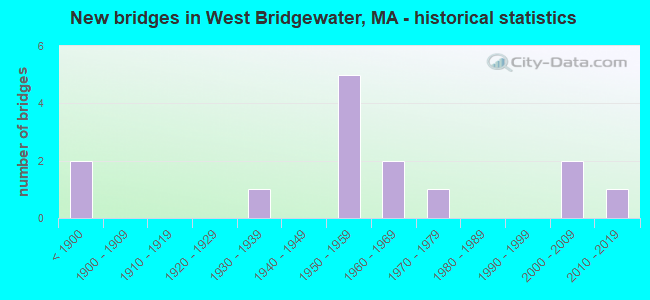
- New bridges - historical statistics
- 2Before 1900
- 11930-1939
- 51950-1959
- 21960-1969
- 11970-1979
- 22000-2009
- 12010-2019

- Reconstructed bridges - Historical Statistics
- 11940-1949
- 01950-1959
- 11960-1969


- Bridge Condition - Deck
- 9.1%Very good
- 45.5%Good
- 18.2%Satisfactory
- 27.3%Fair

- Bridge Condition - Superstructure
- 23.1%Very good
- 23.1%Good
- 23.1%Satisfactory
- 23.1%Fair
- 7.7%Poor

- Bridge Condition - Substructure
- 23.1%Very good
- 23.1%Good
- 30.8%Satisfactory
- 23.1%Fair

- Bridge Condition - Channel
- 30.0%Very good
- 40.0%Good
- 20.0%Satisfactory
- 10.0%Fair
Find on map >> Show street view
Structure Number: W1800146EDOTNBI, Location: 0.2 M S OF RTE 106 (Lat: 42.017503, Lng: -71.003433), Route carried "on" structure: State highway 28, Year Built: 1897, Year Reconstructed: 1947, Status: Posted for load, Structure Length: 1.19m (3.90ft), Average Daily Traffic: 29,100 (year 2020), Truck Traffic: 6%, Average Future Daily Traffic: 45,326 (year 2031), Design Load: H 20, Features Intersected: WATER TOWN RIVER
Minimum Vertical Clearance: 30+ m (98+ ft), Kilometerpoint: 153.608, Lanes on structure: 2, Base Highway Network: Yes, Owner: State Highway Agency, Approaching Roadway Width: 11.9m (39.0ft), Skew: 1 degrees, Material/Design: Masonry, Design/Construction: Arch - Deck, Number Of Spans In Main Unit: 1, Length of Maximum Span: 10.4m (34.1ft), Curb or Sidewalk Widths: Left: 1.9m (6.2ft), Right: 0.3m (1.0ft), Curb-To-Curb Width: 15.3m (50.2ft), Out-to-Out Width: 18.4m (60.4ft)
Condition: Deck: Satisfactory, Superstructure: Good, Substructure: Satisfactory, Channel: Satisfactory, Operating Rating: 40.1 metric tons, Method Used To Determine Operating Rating: Allowable Stress (AS), Inventory Rating: 18.9 metric tons, Method Used To Determine Inventory Rating: Allowable Stress (AS), Structural Evaluation: Meets minimum limits, Deck Geometry: Superior to present desirable criteria, Waterway Adequacy: Equal to present desirable criteria, Approach Roadway Alignment: Equal to present desirable criteria, Length Of Structure Improvement: 1.20m (3.94ft), Designated Inspection Frequency: Every 24 months, Underwater Inspection Frequency: Every 36 months, Inspection Date: May 2020, Underwater Inspection Date: September 2019, Bridge Improvement Cost: $868,000, Roadway Improvement Cost: $87,000, Total Project Cost: $1,303,000 ( Estimate for 2022), Deck Structure Type: Concrete Cast-file-Place, Wearing Surface/Protective System: Wearing Surface: Bituminous
Find on map >> Show street view
Structure Number: W180036AWMUNNBI, Location: ADJACENT TO RIVER AVE (Lat: 42.014967, Lng: -71.012239), Route carried "on" structure: City street , Year Built: 2008, Status: Open, Structure Length: 0.79m (2.59ft), Average Daily Traffic: 4,915 (year 2021), Truck Traffic: 3%, Average Future Daily Traffic: 7,423 (year 2032), Design Load: HS 20, Features Intersected: WATER TOWN RIVER, Facility Carried by Structure: HWY SOUTH ST
Minimum Vertical Clearance: 30+ m (98+ ft), Kilometerpoint: 0.000, Lanes on structure: 2, Owner: Town or Township Highway Agency, Approaching Roadway Width: 8.3m (27.2ft), Material/Design: Concrete, Design/Construction: Arch - Deck, Number Of Spans In Main Unit: 1, Length of Maximum Span: 7.9m (25.9ft), Curb or Sidewalk Widths: Left: 1.6m (5.2ft), Right: 0.0m, Curb-To-Curb Width: 8.4m (27.6ft), Out-to-Out Width: 10.9m (35.8ft)
Condition: Superstructure: Very good, Substructure: Very good, Channel: Very good, Inventory Rating: 55.6 metric tons, Method Used To Determine Inventory Rating: Load Factor (LF), Structural Evaluation: Equal to present desirable criteria, Deck Geometry: High priority of corrective action, Waterway Adequacy: Equal to present desirable criteria, Approach Roadway Alignment: Equal to present desirable criteria, Length Of Structure Improvement: 0.80m (2.62ft), Designated Inspection Frequency: Every 24 months, Inspection Date: May 2021, Bridge Improvement Cost: $379,000, Roadway Improvement Cost: $38,000, Total Project Cost: $569,000 ( Estimate for 2022)
Find on map >> Show street view
Structure Number: W1800444VMUNNBI, Location: .01 M FROM RIVER ST (Lat: 42.013581, Lng: -71.015747), Route carried "on" structure: City street , Year Built: 1968, Status: Posted for load, Structure Length: 1.01m (3.31ft), Average Daily Traffic: 776 (year 2021), Truck Traffic: 6%, Average Future Daily Traffic: 1,579 (year 2032), Features Intersected: WATER TOWN RIVER, Facility Carried by Structure: HWY FOREST ST
Minimum Vertical Clearance: 30+ m (98+ ft), Kilometerpoint: 1.706, Lanes on structure: 2, Owner: Town or Township Highway Agency, Approaching Roadway Width: 7.3m (24.0ft), Material/Design: Steel, Design/Construction: Culvert, Number Of Spans In Main Unit: 2, Length of Maximum Span: 4.3m (14.1ft), Curb-To-Curb Width: 7.3m (24.0ft), Out-to-Out Width: 11.2m (36.7ft)
Condition: Channel: Fair, Culverts: Fair, Structural Evaluation: Somewhat better than minimum adequacy, Deck Geometry: Meets minimum limits, Waterway Adequacy: Equal to present minimum criteria, Approach Roadway Alignment: Equal to present desirable criteria, Length Of Structure Improvement: 0.80m (2.62ft), Designated Inspection Frequency: Every 12 months, Underwater Inspection Frequency: Every 12 months, Inspection Date: July 2021, Underwater Inspection Date: June 2021, Bridge Improvement Cost: $318,000, Roadway Improvement Cost: $32,000, Total Project Cost: $478,000 ( Estimate for 2022)
Find on map >> Show street view
Structure Number: W1800644TMUNNBI, Location: 1.05M FROM RIVER ST (Lat: 42.001306, Lng: -71.018694), Route carried "on" structure: City street , Year Built: 1978, Status: Open, Structure Length: 1.28m (4.20ft), Average Daily Traffic: 100 (year 2021), Average Future Daily Traffic: 158 (year 2032), Design Load: HS 20, Features Intersected: WATER TOWN RIVER, Facility Carried by Structure: HWY FOREST ST
Minimum Vertical Clearance: 30+ m (98+ ft), Kilometerpoint: 0.016, Lanes on structure: 2, Owner: Town or Township Highway Agency, Approaching Roadway Width: 6.1m (20.0ft), Material/Design: Wood or Timber, Design/Construction: Stringer/Multi-beam, Number Of Spans In Main Unit: 1, Length of Maximum Span: 11.9m (39.0ft), Curb-To-Curb Width: 5.3m (17.4ft), Out-to-Out Width: 5.6m (18.4ft)
Condition: Deck: Good, Superstructure: Good, Substructure: Good, Channel: Good, Operating Rating: 38.0 metric tons, Method Used To Determine Operating Rating: Allowable Stress (AS), Inventory Rating: 25.8 metric tons, Method Used To Determine Inventory Rating: Allowable Stress (AS), Structural Evaluation: Equal to present minimum criteria, Deck Geometry: High priority of corrective action, Waterway Adequacy: Meets minimum limits, Approach Roadway Alignment: Equal to present desirable criteria, Length Of Structure Improvement: 1.30m (4.27ft), Designated Inspection Frequency: Every 24 months, Inspection Date: May 2021, Bridge Improvement Cost: $286,000, Roadway Improvement Cost: $29,000, Total Project Cost: $430,000 ( Estimate for 2022), Deck Structure Type: Wood or Timber, Wearing Surface/Protective System: Wearing Surface: Bituminous
Find on map >> Show street view
Structure Number: W1800742MMUNNBI, Location: .1 MI FROM E BRIDGEWATER (Lat: 42.038578, Lng: -70.987917), Route carried "on" structure: City street , Year Built: 1875, Status: Open, Structure Length: 0.91m (2.99ft), Average Daily Traffic: 7,400 (year 2021), Truck Traffic: 10%, Average Future Daily Traffic: 10,660 (year 2032), Features Intersected: WATER SALISBURY PLAIN R, Facility Carried by Structure: HWY BELMONT ST
Minimum Vertical Clearance: 30+ m (98+ ft), Kilometerpoint: 0.080, Lanes on structure: 2, Owner: Town or Township Highway Agency, Approaching Roadway Width: 7.0m (23.0ft), Material/Design: Masonry, Design/Construction: Arch - Deck, Number Of Spans In Main Unit: 1, Length of Maximum Span: 9.1m (29.9ft), Curb-To-Curb Width: 7.1m (23.3ft), Out-to-Out Width: 9.1m (29.9ft)
Condition: Superstructure: Satisfactory, Substructure: Fair, Channel: Good, Operating Rating: 77.7 metric tons, Method Used To Determine Operating Rating: Allowable Stress (AS), Inventory Rating: 77.7 metric tons, Method Used To Determine Inventory Rating: Allowable Stress (AS), Structural Evaluation: Somewhat better than minimum adequacy, Deck Geometry: High priority of replacement, Waterway Adequacy: Superior to present desirable criteria, Approach Roadway Alignment: Meets minimum limits, Length Of Structure Improvement: 1.00m (3.28ft), Designated Inspection Frequency: Every 24 months, Inspection Date: September 2021, Bridge Improvement Cost: $358,000, Roadway Improvement Cost: $36,000, Total Project Cost: $538,000 ( Estimate for 2022)
Find on map >> Show street view
Structure Number: W180116G5MUNNBI, Location: .1 MI N OF BRIDGEWATER (Lat: 41.991872, Lng: -71.025831), Route carried "on" structure: City street , Year Built: 2009, Status: Open, Structure Length: 1.97m (6.46ft), Average Daily Traffic: 2,198 (year 2019), Truck Traffic: 7%, Average Future Daily Traffic: 1,895 (year 2032), Design Load: HS 20, Features Intersected: WATER TOWN RIVER, Facility Carried by Structure: HWY SCOTLAND ST
Minimum Vertical Clearance: 30+ m (98+ ft), Kilometerpoint: 0.113, Lanes on structure: 2, Owner: Town or Township Highway Agency, Approaching Roadway Width: 8.6m (28.2ft), Material/Design: Prestressed concrete, Design/Construction: Box Beam or Girders - Single/Spread, Number Of Spans In Main Unit: 1, Length of Maximum Span: 17.2m (56.4ft), Curb-To-Curb Width: 8.0m (26.2ft), Out-to-Out Width: 9.0m (29.5ft)
Condition: Deck: Good, Superstructure: Very good, Substructure: Very good, Channel: Very good, Operating Rating: 77.1 metric tons, Method Used To Determine Operating Rating: Load Factor (LF), Inventory Rating: 46.2 metric tons, Method Used To Determine Inventory Rating: Load Factor (LF), Structural Evaluation: Equal to present desirable criteria, Deck Geometry: High priority of corrective action, Waterway Adequacy: Better than present minimum criteria, Approach Roadway Alignment: Equal to present desirable criteria, Length Of Structure Improvement: 2.00m (6.56ft), Designated Inspection Frequency: Every 24 months, Inspection Date: August 2021, Bridge Improvement Cost: $1,019,000, Roadway Improvement Cost: $102,000, Total Project Cost: $1,529,000 ( Estimate for 2022), Deck Structure Type: Concrete Cast-file-Place, Wearing Surface/Protective System: Wearing Surface: Integral Concrete, Deck Protection: Epoxy Coated Reinforcing
Find on map >> Show street view
Structure Number: W18012BLMDOTNBI, Location: .5 MI E OF ST 138 (Lat: 42.011222, Lng: -71.058206), Route carried "on" structure: State highway 106, Year Built: 2017, Status: Open, Structure Length: 2.09m (6.86ft), Average Daily Traffic: 15,742 (year 2019), Truck Traffic: 6%, Design Load: HL 93, Features Intersected: WATER HOCKOMOCK RIVER
Minimum Vertical Clearance: 30+ m (98+ ft), Kilometerpoint: 24.600, Lanes on structure: 2, Base Highway Network: Yes, Owner: State Highway Agency, Approaching Roadway Width: 9.8m (32.2ft), Material/Design: Steel, Design/Construction: Stringer/Multi-beam, Number Of Spans In Main Unit: 1, Length of Maximum Span: 19.8m (65.0ft), Curb or Sidewalk Widths: Left: 2.3m (7.5ft), Right: 2.3m (7.5ft), Curb-To-Curb Width: 9.8m (32.2ft), Out-to-Out Width: 14.3m (46.9ft)
Condition: Deck: Very good, Superstructure: Very good, Substructure: Very good, Channel: Very good, Operating Rating: 58.3 metric tons, Method Used To Determine Operating Rating: Load and Resistance Factor Rating (LRFR) rating reported by rating factor(RF) method using HL-93 loadings, Inventory Rating: 45.4 metric tons, Method Used To Determine Inventory Rating: Load and Resistance Factor Rating (LRFR) rating reported by rating factor(RF) method using HL-93 loadings, Structural Evaluation: Equal to present desirable criteria, Deck Geometry: Meets minimum limits, Waterway Adequacy: Superior to present desirable criteria, Approach Roadway Alignment: Equal to present desirable criteria, Designated Inspection Frequency: Every 24 months, Inspection Date: July 2021, Deck Structure Type: Concrete Precast Panels, Wearing Surface/Protective System: Wearing Surface: Bituminous, Membrane: Other, Deck Protection: Epoxy Coated Reinforcing
Find on map >> Show street view
Structure Number: W1801342NMUNNBI, Location: .2 MI E OF EASTON (Lat: 42.039669, Lng: -71.062647), Route carried "on" structure: City street , Year Built: 1967, Status: Open, Structure Length: 1.80m (5.91ft), Average Daily Traffic: 4,000 (year 2018), Truck Traffic: 19%, Average Future Daily Traffic: 10,897 (year 2031), Design Load: H 20, Features Intersected: WATER COWESSETT BROOK, Facility Carried by Structure: HWY WALNUT ST
Minimum Vertical Clearance: 30+ m (98+ ft), Kilometerpoint: 0.402, Lanes on structure: 2, Owner: Town or Township Highway Agency, Approaching Roadway Width: 9.1m (29.9ft), Material/Design: Concrete continuous, Design/Construction: Slab, Number Of Spans In Main Unit: 3, Length of Maximum Span: 5.8m (19.0ft), Curb or Sidewalk Widths: Left: 1.5m (4.9ft), Right: 0.4m (1.3ft), Curb-To-Curb Width: 9.1m (29.9ft), Out-to-Out Width: 11.9m (39.0ft)
Condition: Deck: Good, Superstructure: Good, Substructure: Good, Channel: Good, Operating Rating: 45.1 metric tons, Method Used To Determine Operating Rating: Allowable Stress (AS), Inventory Rating: 28.8 metric tons, Method Used To Determine Inventory Rating: Allowable Stress (AS), Structural Evaluation: Better than present minimum criteria, Deck Geometry: Meets minimum limits, Waterway Adequacy: Equal to present desirable criteria, Approach Roadway Alignment: Equal to present minimum criteria, Length Of Structure Improvement: 1.90m (6.23ft), Designated Inspection Frequency: Every 24 months, Inspection Date: September 2020, Bridge Improvement Cost: $889,000, Roadway Improvement Cost: $89,000, Total Project Cost: $1,334,000 ( Estimate for 2022), Deck Structure Type: Concrete Cast-file-Place, Wearing Surface/Protective System: Wearing Surface: Bituminous, Membrane: Built-up
Find on map >> Show street view
Structure Number: W1801444UMUNNBI, Location: .2 MI W OF RTE 24 (Lat: 42.024336, Lng: -71.060108), Route carried "on" structure: City street , Year Built: 1935, Status: Posted for load, Structure Length: 1.19m (3.90ft), Average Daily Traffic: 3,857 (year 2020), Truck Traffic: 15%, Average Future Daily Traffic: 9,476 (year 2031), Features Intersected: WATER COWESSETT BROOK, Facility Carried by Structure: HWY WEST ST
Minimum Vertical Clearance: 30+ m (98+ ft), Kilometerpoint: 0.274, Lanes on structure: 2, Owner: Town or Township Highway Agency, Approaching Roadway Width: 9.1m (29.9ft), Skew: 2 degrees, Material/Design: Concrete, Design/Construction: Slab, Number Of Spans In Main Unit: 2, Length of Maximum Span: 4.9m (16.1ft), Curb-To-Curb Width: 9.1m (29.9ft), Out-to-Out Width: 9.8m (32.2ft)
Condition: Deck: Fair, Superstructure: Fair, Substructure: Satisfactory, Channel: Satisfactory, Operating Rating: 49.4 metric tons, Method Used To Determine Operating Rating: Load Factor (LF), Inventory Rating: 33.0 metric tons, Method Used To Determine Inventory Rating: Load Factor (LF), Structural Evaluation: Somewhat better than minimum adequacy, Deck Geometry: Meets minimum limits, Waterway Adequacy: Better than present minimum criteria, Approach Roadway Alignment: Equal to present desirable criteria, Length Of Structure Improvement: 1.20m (3.94ft), Designated Inspection Frequency: Every 24 months, Underwater Inspection Frequency: Every 36 months, Inspection Date: May 2020, Underwater Inspection Date: November 2021, Bridge Improvement Cost: $462,000, Roadway Improvement Cost: $47,000, Total Project Cost: $694,000 ( Estimate for 2022), Deck Structure Type: Concrete Cast-file-Place, Wearing Surface/Protective System: Wearing Surface: Bituminous
Find on map >> Show street view
Structure Number: W180163MWDOTNBI, Location: .1 MI N OF BRIDGEWATER TL (Lat: 41.990494, Lng: -71.028722), Route carried "on" structure: State highway 24, Year Built: 1952, Year Reconstructed: 1974, Status: Open, Structure Length: 1.51m (4.95ft), Average Daily Traffic: 88,000 (year 2020), Truck Traffic: 3%, Average Future Daily Traffic: 118,448 (year 2032), Design Load: HS 20, Features Intersected: WATER TOWN RIVER
Minimum Vertical Clearance: 30+ m (98+ ft), Kilometerpoint: 41.391, Lanes on structure: 6, Base Highway Network: Yes, Owner: State Highway Agency, Approaching Roadway Width: 33.5m (109.9ft), Skew: 30 degrees, Material/Design: Concrete, Design/Construction: Tee Beam, Number Of Spans In Main Unit: 1, Length of Maximum Span: 14.1m (46.3ft), Curb-To-Curb Width: 34.7m (113.8ft), Out-to-Out Width: 36.6m (120.1ft)
Condition: Deck: Good, Superstructure: Fair, Substructure: Satisfactory, Channel: Good, Operating Rating: 56.5 metric tons, Method Used To Determine Operating Rating: Load Factor (LF), Inventory Rating: 33.9 metric tons, Method Used To Determine Inventory Rating: Load Factor (LF), Structural Evaluation: Somewhat better than minimum adequacy, Deck Geometry: Superior to present desirable criteria, Waterway Adequacy: Equal to present desirable criteria, Approach Roadway Alignment: Equal to present desirable criteria, Length Of Structure Improvement: 1.60m (5.25ft), Designated Inspection Frequency: Every 24 months, Underwater Inspection Frequency: Every 36 months, Inspection Date: May 2021, Underwater Inspection Date: August 2020, Bridge Improvement Cost: $2,302,000, Roadway Improvement Cost: $231,000, Total Project Cost: $3,454,000 ( Estimate for 2022), Deck Structure Type: Concrete Cast-file-Place, Wearing Surface/Protective System: Wearing Surface: Bituminous, Membrane: Built-up
Find on map >> Show street view
Structure Number: W180173W1DOTNBI, Location: .75 MI SO OF WEST ST (Lat: 42.014522, Lng: -71.044031), Route carried "on" structure: State highway 106, Year Built: 1954, Status: Open, Structure Length: 3.69m (12.11ft), Average Daily Traffic: 27,582 (year 2019), Truck Traffic: 14%, Average Future Daily Traffic: 54,802 (year 2032), Design Load: H 20, Features Intersected: ST 24
Minimum Vertical Clearance: 30+ m (98+ ft), Kilometerpoint: 25.794, Lanes on structure: 4, Lanes under structure: 8, Base Highway Network: Yes, Owner: State Highway Agency, Approaching Roadway Width: 17.1m (56.1ft), Skew: 20 degrees, Material/Design: Steel, Design/Construction: Stringer/Multi-beam, Number Of Spans In Main Unit: 2, Length of Maximum Span: 17.7m (58.1ft), Curb or Sidewalk Widths: Left: 1.1m (3.6ft), Right: 1.8m (5.9ft), Curb-To-Curb Width: 17.2m (56.4ft), Out-to-Out Width: 21.3m (69.9ft)
Condition: Deck: Fair, Superstructure: Fair, Substructure: Fair, Operating Rating: 33.6 metric tons, Method Used To Determine Operating Rating: Load Factor (LF), Inventory Rating: 24.6 metric tons, Method Used To Determine Inventory Rating: Load Factor (LF), Structural Evaluation: Somewhat better than minimum adequacy, Deck Geometry: Somewhat better than minimum adequacy, Underclear: High priority of corrective action, Approach Roadway Alignment: Equal to present desirable criteria, Length Of Structure Improvement: 3.70m (12.14ft), Designated Inspection Frequency: Every 24 months, Inspection Date: September 2021, Bridge Improvement Cost: $3,096,000, Roadway Improvement Cost: $310,000, Total Project Cost: $4,645,000 ( Estimate for 2022), Deck Structure Type: Concrete Cast-file-Place, Wearing Surface/Protective System: Wearing Surface: Bituminous, Membrane: Built-up
Find on map >> Show street view
Structure Number: W180183MXDOTNBI, Location: 1 MI N BRIDGEWATER T L (Lat: 42.002914, Lng: -71.036628), Route carried "on" structure: State highway 24, Year Built: 1953, Status: Open, Structure Length: 1.40m (4.59ft), Average Daily Traffic: 104,009 (year 2019), Truck Traffic: 3%, Average Future Daily Traffic: 138,505 (year 2033), Design Load: H 20, Features Intersected: HWY S ELM ST
Minimum Vertical Clearance: 30+ m (98+ ft), Kilometerpoint: 43.000, Lanes on structure: 6, Lanes under structure: 2, Base Highway Network: Yes, Owner: State Highway Agency, Approaching Roadway Width: 30.5m (100.1ft), Skew: 30 degrees, Material/Design: Concrete, Design/Construction: Tee Beam, Number Of Spans In Main Unit: 1, Length of Maximum Span: 13.4m (44.0ft), Curb or Sidewalk Widths: Left: 0.2m (0.7ft), Right: 0.2m (0.7ft), Curb-To-Curb Width: 30.5m (100.1ft), Out-to-Out Width: 36.9m (121.1ft)
Condition: Deck: Satisfactory, Superstructure: Satisfactory, Substructure: Good, Operating Rating: 47.0 metric tons, Method Used To Determine Operating Rating: Load Factor (LF), Inventory Rating: 30.3 metric tons, Method Used To Determine Inventory Rating: Load Factor (LF), Structural Evaluation: Equal to present minimum criteria, Deck Geometry: Superior to present desirable criteria, Underclear: Meets minimum limits, Approach Roadway Alignment: Equal to present desirable criteria, Length Of Structure Improvement: 1.50m (4.92ft), Designated Inspection Frequency: Every 24 months, Inspection Date: Febuary 2022, Bridge Improvement Cost: $2,175,000, Roadway Improvement Cost: $218,000, Total Project Cost: $3,263,000 ( Estimate for 2022), Deck Structure Type: Concrete Cast-file-Place, Wearing Surface/Protective System: Wearing Surface: Bituminous, Membrane: Built-up
Find on map >> Show street view
Structure Number: W180193WWDOTNBI, Location: .8 MI NORTH OF ST106 (Lat: 42.023056, Lng: -71.048481), Route carried "on" structure: City street , Year Built: 1953, Status: Posted for load, Structure Length: 3.96m (12.99ft), Average Daily Traffic: 5,560 (year 2019), Truck Traffic: 6%, Average Future Daily Traffic: 10,265 (year 2032), Design Load: H 20, Features Intersected: ST 24, Facility Carried by Structure: HWY WEST ST
Minimum Vertical Clearance: 30+ m (98+ ft), Kilometerpoint: 1.287, Lanes on structure: 2, Lanes under structure: 6, Owner: State Highway Agency, Approaching Roadway Width: 9.1m (29.9ft), Skew: 3 degrees, Material/Design: Steel, Design/Construction: Stringer/Multi-beam, Number Of Spans In Main Unit: 2, Length of Maximum Span: 19.5m (64.0ft), Curb or Sidewalk Widths: Left: 1.5m (4.9ft), Right: 0.3m (1.0ft), Curb-To-Curb Width: 9.1m (29.9ft), Out-to-Out Width: 11.6m (38.1ft)
Condition: Deck: Good, Superstructure: Satisfactory, Substructure: Satisfactory, Operating Rating: 33.7 metric tons, Method Used To Determine Operating Rating: Allowable Stress (AS), Inventory Rating: 18.4 metric tons, Method Used To Determine Inventory Rating: Allowable Stress (AS), Structural Evaluation: Meets minimum limits, Deck Geometry: High priority of corrective action, Underclear: High priority of corrective action, Approach Roadway Alignment: Better than present minimum criteria, Length Of Structure Improvement: 4.00m (13.12ft), Designated Inspection Frequency: Every 24 months, Inspection Date: September 2021, Bridge Improvement Cost: $1,823,000, Roadway Improvement Cost: $183,000, Total Project Cost: $2,735,000 ( Estimate for 2022), Deck Structure Type: Concrete Cast-file-Place, Wearing Surface/Protective System: Wearing Surface: Bituminous, Membrane: Built-up
Find on map >> Show street view
Structure Number: W180203YRDOTNBI, Location: .2 MI EAST OF MANLEY ROAD (Lat: 42.041464, Lng: -71.054817), Route carried "on" structure: City street , Year Built: 1953, Status: Posted for load, Structure Length: 3.81m (12.50ft), Average Daily Traffic: 2,400 (year 2021), Truck Traffic: 6%, Average Future Daily Traffic: 3,948 (year 2032), Design Load: H 20, Features Intersected: ST 24, Facility Carried by Structure: HWY WALNUT ST
Minimum Vertical Clearance: 30+ m (98+ ft), Kilometerpoint: 0.000, Lanes on structure: 2, Lanes under structure: 6, Owner: State Highway Agency, Approaching Roadway Width: 9.1m (29.9ft), Skew: 1 degrees, Material/Design: Steel, Design/Construction: Stringer/Multi-beam, Number Of Spans In Main Unit: 2, Length of Maximum Span: 17.7m (58.1ft), Curb or Sidewalk Widths: Left: 1.8m (5.9ft), Right: 0.6m (2.0ft), Curb-To-Curb Width: 9.1m (29.9ft), Out-to-Out Width: 11.6m (38.1ft)
Condition: Deck: Fair, Superstructure: Poor, Substructure: Fair, Operating Rating: 35.1 metric tons, Method Used To Determine Operating Rating: Load Factor (LF), Inventory Rating: 21.0 metric tons, Method Used To Determine Inventory Rating: Load Factor (LF), Structural Evaluation: Meets minimum limits, Deck Geometry: Meets minimum limits, Underclear: High priority of replacement, Approach Roadway Alignment: Equal to present desirable criteria, Length Of Structure Improvement: 4.80m (15.75ft), Designated Inspection Frequency: Every 12 months, Other Special Inspection Frequency: Every 12 months, Inspection Date: September 2021, Other Special Inspection Date: September 2021, Bridge Improvement Cost: $3,998,000, Roadway Improvement Cost: $400,000, Total Project Cost: $5,998,000 ( Estimate for 2022), Deck Structure Type: Concrete Cast-file-Place, Wearing Surface/Protective System: Wearing Surface: Bituminous, Membrane: Built-up, Deck Protection: Other