Bridge Statistics for West Carrollton City, Ohio (OH)
Condition, Traffic, Stress, Structural Evaluation, Project Costs
- National Bridge Inventory (NBI) Statistics
- 22Number of bridges
- 328ft / 99.9mTotal length
- 515,341Total average daily traffic
- 60,101Total average daily truck traffic
- National Bridge Inventory (NBI) Registered Bridges for West Carrollton City
- No street view available for this location
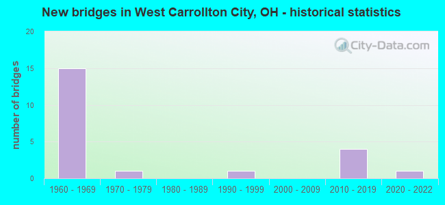
- New bridges - historical statistics
- 151960-1969
- 11970-1979
- 11990-1999
- 42010-2019
- 12020-2022
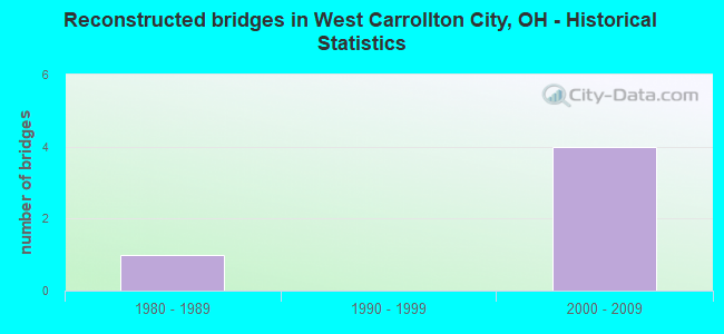
- Reconstructed bridges - Historical Statistics
- 11980-1989
- 01990-1999
- 42000-2009
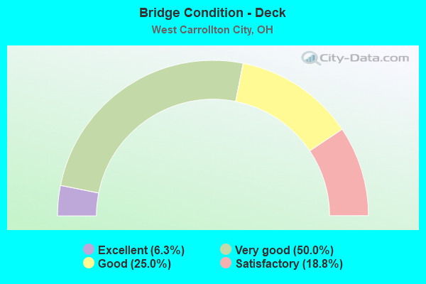
- Bridge Condition - Deck
- 6.3%Excellent
- 50.0%Very good
- 25.0%Good
- 18.8%Satisfactory
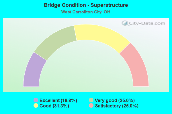
- Bridge Condition - Superstructure
- 18.8%Excellent
- 25.0%Very good
- 31.3%Good
- 25.0%Satisfactory

- Bridge Condition - Substructure
- 6.3%Excellent
- 25.0%Very good
- 50.0%Good
- 18.8%Satisfactory
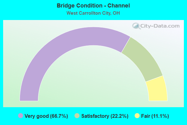
- Bridge Condition - Channel
- 66.7%Very good
- 22.2%Satisfactory
- 11.1%Fair
Find on map >> Show street view
Structure Number: 5706572, Location: 3.44MI.S. OF JCT. SR-741 (Lat: 39.673619, Lng: -84.232750), Route carried "on" structure: Interstate 75, Year Built: 1960, Status: Open, Structure Length: 3.99m (13.09ft), Average Daily Traffic: 50,323 (year 2015), Truck Traffic: 14%, Average Future Daily Traffic: 69,848 (year 2035), Design Load: HS 20, Features Intersected: ALEX BELL ROAD
Minimum Vertical Clearance: 30+ m (98+ ft), Kilometerpoint: 9.881, Lanes on structure: 3, Lanes under structure: 3, Base Highway Network: Yes, Owner: State Highway Agency, Approaching Roadway Width: 11.0m (36.1ft), Skew: 1 degrees, Material/Design: Concrete continuous, Design/Construction: Slab, Number Of Spans In Main Unit: 3, Length of Maximum Span: 14.3m (46.9ft), Curb-To-Curb Width: 15.8m (51.8ft), Out-to-Out Width: 17.2m (56.4ft)
Condition: Deck: Satisfactory, Superstructure: Satisfactory, Substructure: Good, Operating Rating: 42.1 metric tons, Method Used To Determine Operating Rating: Load Factor (LF) rating reported by rating factor (RF) method using MS18 loading, Inventory Rating: 32.4 metric tons, Method Used To Determine Inventory Rating: Load Factor (LF) rating reported by rating factor (RF) method using MS18 loading, Structural Evaluation: Equal to present minimum criteria, Deck Geometry: Somewhat better than minimum adequacy, Underclear: Somewhat better than minimum adequacy, Approach Roadway Alignment: Superior to present desirable criteria, Designated Inspection Frequency: Every 12 months, Inspection Date: November 2021, Deck Structure Type: Concrete Cast-file-Place, Wearing Surface/Protective System: Wearing Surface: Bituminous
Find on map >> Show street view
Structure Number: 5706602, Location: 3.44MI.S OF JCT. SR-741 (Lat: 39.673681, Lng: -84.233531), Route carried "on" structure: Interstate 75, Year Built: 1960, Status: Open, Structure Length: 3.99m (13.09ft), Average Daily Traffic: 50,323 (year 2015), Truck Traffic: 14%, Average Future Daily Traffic: 69,848 (year 2035), Design Load: HS 20, Features Intersected: ALEX BELL ROAD
Minimum Vertical Clearance: 30+ m (98+ ft), Kilometerpoint: 9.881, Lanes on structure: 3, Lanes under structure: 3, Base Highway Network: Yes, Owner: State Highway Agency, Approaching Roadway Width: 11.0m (36.1ft), Skew: 1 degrees, Material/Design: Concrete continuous, Design/Construction: Slab, Number Of Spans In Main Unit: 3, Length of Maximum Span: 14.3m (46.9ft), Curb-To-Curb Width: 15.8m (51.8ft), Out-to-Out Width: 17.2m (56.4ft)
Condition: Deck: Satisfactory, Superstructure: Satisfactory, Substructure: Good, Operating Rating: 42.1 metric tons, Method Used To Determine Operating Rating: Load Factor (LF) rating reported by rating factor (RF) method using MS18 loading, Inventory Rating: 32.4 metric tons, Method Used To Determine Inventory Rating: Load Factor (LF) rating reported by rating factor (RF) method using MS18 loading, Structural Evaluation: Equal to present minimum criteria, Deck Geometry: Somewhat better than minimum adequacy, Underclear: Somewhat better than minimum adequacy, Approach Roadway Alignment: Superior to present desirable criteria, Designated Inspection Frequency: Every 12 months, Inspection Date: November 2021, Deck Structure Type: Concrete Cast-file-Place, Wearing Surface/Protective System: Wearing Surface: Bituminous
Find on map >> Show street view
Structure Number: 5706637, Location: 3.19MI.S OF JCT. SR-741 (Lat: 39.677119, Lng: -84.231411), Route carried "on" structure: Interstate 75, Year Built: 1960, Status: Open, Structure Length: 9.81m (32.19ft), Average Daily Traffic: 50,323 (year 2015), Truck Traffic: 14%, Average Future Daily Traffic: 69,848 (year 2035), Design Load: HS 20+Mod, Features Intersected: NS RR EAST DIXIE DRIVE*E
Minimum Vertical Clearance: 30+ m (98+ ft), Kilometerpoint: 10.284, Lanes on structure: 5, Lanes under structure: 2, Base Highway Network: Yes, Owner: State Highway Agency, Approaching Roadway Width: 11.0m (36.1ft), Skew: 4 degrees, Material/Design: Steel continuous, Design/Construction: Stringer/Multi-beam, Number Of Spans In Main Unit: 5, Length of Maximum Span: 20.7m (67.9ft), Curb-To-Curb Width: 22.6m (74.1ft), Out-to-Out Width: 24.0m (78.7ft)
Condition: Deck: Good, Superstructure: Good, Substructure: Very good, Operating Rating: 58.3 metric tons, Method Used To Determine Operating Rating: Allowable Stress (AS) rating reported by rating factor (RF) method using MS18 loading, Inventory Rating: 35.6 metric tons, Method Used To Determine Inventory Rating: Allowable Stress (AS) rating reported by rating factor (RF) method using MS18 loading, Structural Evaluation: Better than present minimum criteria, Deck Geometry: Meets minimum limits, Underclear: High priority of corrective action, Approach Roadway Alignment: Equal to present desirable criteria, Designated Inspection Frequency: Every 24 months, Inspection Date: November 2021, Deck Structure Type: Concrete Cast-file-Place, Wearing Surface/Protective System: Wearing Surface: Integral Concrete
Find on map >> Show street view
Structure Number: 5706661, Location: 3.19MI.S. OF JCT. SR-741 (Lat: 39.676731, Lng: -84.232381), Route carried "on" structure: Interstate 75, Year Built: 1960, Status: Open, Structure Length: 8.90m (29.20ft), Average Daily Traffic: 50,323 (year 2015), Truck Traffic: 14%, Average Future Daily Traffic: 69,848 (year 2035), Design Load: HS 20+Mod, Features Intersected: NS RR EAST DIXIE DRIVE*E
Minimum Vertical Clearance: 30+ m (98+ ft), Kilometerpoint: 10.284, Lanes on structure: 4, Lanes under structure: 2, Base Highway Network: Yes, Owner: State Highway Agency, Approaching Roadway Width: 11.0m (36.1ft), Skew: 4 degrees, Material/Design: Steel continuous, Design/Construction: Stringer/Multi-beam, Number Of Spans In Main Unit: 4, Length of Maximum Span: 23.2m (76.1ft), Curb-To-Curb Width: 19.4m (63.6ft), Out-to-Out Width: 20.8m (68.2ft)
Condition: Deck: Good, Superstructure: Good, Substructure: Very good, Operating Rating: 61.6 metric tons, Method Used To Determine Operating Rating: Allowable Stress (AS) rating reported by rating factor (RF) method using MS18 loading, Inventory Rating: 35.6 metric tons, Method Used To Determine Inventory Rating: Allowable Stress (AS) rating reported by rating factor (RF) method using MS18 loading, Structural Evaluation: Better than present minimum criteria, Deck Geometry: Somewhat better than minimum adequacy, Underclear: High priority of corrective action, Approach Roadway Alignment: Equal to present desirable criteria, Designated Inspection Frequency: Every 24 months, Inspection Date: November 2021, Deck Structure Type: Concrete Cast-file-Place, Wearing Surface/Protective System: Wearing Surface: Integral Concrete
Find on map >> Show street view
Structure Number: 5706726, Location: 2.92MI.S OF JCT. SR-741 (Lat: 39.681189, Lng: -84.230711), Route carried "on" structure: Interstate 75, Year Built: 1966, Year Reconstructed: 2012, Status: Open, Structure Length: 9.36m (30.71ft), Average Daily Traffic: 45,579 (year 2015), Truck Traffic: 14%, Average Future Daily Traffic: 63,264 (year 2035), Design Load: HS 20+Mod, Features Intersected: CENTRAL AVE
Minimum Vertical Clearance: 30+ m (98+ ft), Kilometerpoint: 10.718, Lanes on structure: 3, Lanes under structure: 3, Base Highway Network: Yes, Owner: State Highway Agency, Approaching Roadway Width: 11.0m (36.1ft), Skew: 4 degrees, Material/Design: Steel continuous, Design/Construction: Stringer/Multi-beam, Number Of Spans In Main Unit: 4, Length of Maximum Span: 25.9m (85.0ft), Curb-To-Curb Width: 15.7m (51.5ft), Out-to-Out Width: 17.2m (56.4ft)
Condition: Deck: Very good, Superstructure: Good, Substructure: Very good, Operating Rating: 68.0 metric tons, Method Used To Determine Operating Rating: Load Factor (LF) rating reported by rating factor (RF) method using MS18 loading, Inventory Rating: 45.4 metric tons, Method Used To Determine Inventory Rating: Load Factor (LF) rating reported by rating factor (RF) method using MS18 loading, Structural Evaluation: Better than present minimum criteria, Deck Geometry: Somewhat better than minimum adequacy, Underclear: High priority of corrective action, Approach Roadway Alignment: Equal to present desirable criteria, Designated Inspection Frequency: Every 24 months, Inspection Date: November 2021, Deck Structure Type: Concrete Cast-file-Place, Wearing Surface/Protective System: Wearing Surface: Integral Concrete
Find on map >> Show street view
Structure Number: 5706742, Location: 2.9MI. S. OF JCT SR-741 (Lat: 39.680781, Lng: -84.230050), Route carried "on" structure: Interstate 75, Year Built: 2011, Status: Open, Structure Length: 10.52m (34.51ft), Average Daily Traffic: 45,579 (year 2015), Truck Traffic: 14%, Average Future Daily Traffic: 63,264 (year 2035), Design Load: HS 25 or greater, Features Intersected: CENTRAL AVE*W
Minimum Vertical Clearance: 30+ m (98+ ft), Kilometerpoint: 10.694, Lanes on structure: 3, Lanes under structure: 6, Base Highway Network: Yes, Owner: State Highway Agency, Approaching Roadway Width: 19.5m (64.0ft), Skew: 4 degrees, Material/Design: Steel continuous, Design/Construction: Stringer/Multi-beam, Number Of Spans In Main Unit: 4, Length of Maximum Span: 33.8m (110.9ft), Curb-To-Curb Width: 19.5m (64.0ft), Out-to-Out Width: 20.4m (66.9ft)
Condition: Deck: Very good, Superstructure: Excellent, Substructure: Good, Operating Rating: 68.0 metric tons, Method Used To Determine Operating Rating: Load Factor (LF) rating reported by rating factor (RF) method using MS18 loading, Inventory Rating: 38.9 metric tons, Method Used To Determine Inventory Rating: Load Factor (LF) rating reported by rating factor (RF) method using MS18 loading, Structural Evaluation: Better than present minimum criteria, Deck Geometry: Superior to present desirable criteria, Underclear: High priority of corrective action, Approach Roadway Alignment: Equal to present desirable criteria, Designated Inspection Frequency: Every 24 months, Inspection Date: November 2021, Deck Structure Type: Concrete Cast-file-Place, Wearing Surface/Protective System: Wearing Surface: Monolithic Concrete, Membrane: Epoxy, Deck Protection: Epoxy Coated Reinforcing
Find on map >> Show street view
Structure Number: 5706785, Location: 2.72MI.S. OF JCT. SR-741 (Lat: 39.683800, Lng: -84.229800), Route carried "on" structure: Interstate 75, Year Built: 1966, Year Reconstructed: 2012, Status: Open, Structure Length: 4.75m (15.58ft), Average Daily Traffic: 50,329 (year 2015), Truck Traffic: 14%, Average Future Daily Traffic: 69,857 (year 2035), Design Load: HS 20, Features Intersected: HOLES CREEK
Minimum Vertical Clearance: 30+ m (98+ ft), Kilometerpoint: 11.040, Lanes on structure: 4, Base Highway Network: Yes, Owner: State Highway Agency, Approaching Roadway Width: 16.4m (53.8ft), Material/Design: Steel continuous, Design/Construction: Stringer/Multi-beam, Number Of Spans In Main Unit: 3, Length of Maximum Span: 18.3m (60.0ft), Curb-To-Curb Width: 18.6m (61.0ft), Out-to-Out Width: 20.0m (65.6ft)
Condition: Deck: Very good, Superstructure: Good, Substructure: Good, Channel: Very good, Operating Rating: 58.3 metric tons, Method Used To Determine Operating Rating: Load Factor (LF) rating reported by rating factor (RF) method using MS18 loading, Inventory Rating: 35.6 metric tons, Method Used To Determine Inventory Rating: Load Factor (LF) rating reported by rating factor (RF) method using MS18 loading, Structural Evaluation: Better than present minimum criteria, Deck Geometry: Meets minimum limits, Waterway Adequacy: Superior to present desirable criteria, Approach Roadway Alignment: Superior to present desirable criteria, Designated Inspection Frequency: Every 24 months, Inspection Date: November 2021, Deck Structure Type: Concrete Cast-file-Place, Wearing Surface/Protective System: Wearing Surface: Integral Concrete
Find on map >> Show street view
Structure Number: 5706815, Location: 2.72MI.S. OF JCT. SR-741 (Lat: 39.683769, Lng: -84.229181), Route carried "on" structure: Interstate 75, Year Built: 1966, Status: Open, Structure Length: 5.03m (16.50ft), Average Daily Traffic: 50,329 (year 2015), Truck Traffic: 14%, Average Future Daily Traffic: 69,857 (year 2035), Design Load: HS 20+Mod, Features Intersected: HOLES CREEK
Minimum Vertical Clearance: 30+ m (98+ ft), Kilometerpoint: 11.040, Lanes on structure: 4, Base Highway Network: Yes, Owner: State Highway Agency, Approaching Roadway Width: 11.0m (36.1ft), Material/Design: Steel continuous, Design/Construction: Stringer/Multi-beam, Number Of Spans In Main Unit: 3, Length of Maximum Span: 18.3m (60.0ft), Curb-To-Curb Width: 21.5m (70.5ft), Out-to-Out Width: 24.0m (78.7ft)
Condition: Deck: Very good, Superstructure: Very good, Substructure: Good, Channel: Very good, Operating Rating: 94.0 metric tons, Method Used To Determine Operating Rating: Load Factor (LF) rating reported by rating factor (RF) method using MS18 loading, Inventory Rating: 55.1 metric tons, Method Used To Determine Inventory Rating: Load Factor (LF) rating reported by rating factor (RF) method using MS18 loading, Structural Evaluation: Better than present minimum criteria, Deck Geometry: Better than present minimum criteria, Waterway Adequacy: Superior to present desirable criteria, Approach Roadway Alignment: Superior to present desirable criteria, Designated Inspection Frequency: Every 24 months, Inspection Date: November 2021, Deck Structure Type: Concrete Cast-file-Place, Wearing Surface/Protective System: Wearing Surface: Integral Concrete, Membrane: Epoxy, Deck Protection: Epoxy Coated Reinforcing
Find on map >> Show street view
Structure Number: 5764688, Location: .5 MILES S DAYTON CIN PK (Lat: 39.667631, Lng: -84.241200), Route carried "on" structure: City street M0159, Year Built: 2010, Status: Open, Structure Length: 2.29m (7.51ft), Average Daily Traffic: 14,591 (year 2018), Truck Traffic: 6%, Average Future Daily Traffic: 20,252 (year 2038), Design Load: HL 93, Features Intersected: Owl Creek
Minimum Vertical Clearance: 30+ m (98+ ft), Kilometerpoint: 3.943, Lanes on structure: 5, Owner: County Highway Agency, Approaching Roadway Width: 16.5m (54.1ft), Material/Design: Concrete continuous, Design/Construction: Slab, Number Of Spans In Main Unit: 3, Length of Maximum Span: 8.5m (27.9ft), Curb or Sidewalk Widths: Left: 1.5m (4.9ft), Right: 1.5m (4.9ft), Curb-To-Curb Width: 16.2m (53.1ft), Out-to-Out Width: 20.0m (65.6ft)
Condition: Deck: Very good, Superstructure: Very good, Substructure: Very good, Channel: Satisfactory, Operating Rating: 74.5 metric tons, Method Used To Determine Operating Rating: Load Factor (LF) rating reported by rating factor (RF) method using MS18 loading, Inventory Rating: 55.1 metric tons, Method Used To Determine Inventory Rating: Load Factor (LF) rating reported by rating factor (RF) method using MS18 loading, Structural Evaluation: Equal to present desirable criteria, Deck Geometry: High priority of replacement, Waterway Adequacy: Superior to present desirable criteria, Approach Roadway Alignment: Equal to present desirable criteria, Designated Inspection Frequency: Every 24 months, Inspection Date: June 2021, Deck Structure Type: Other, Wearing Surface/Protective System: Wearing Surface: Monolithic Concrete, Deck Protection: Epoxy Coated Reinforcing
Find on map >> Show street view
Structure Number: 5764718, Location: 600 FT EAST OF MAYROSE ST (Lat: 39.664319, Lng: -84.243431), Route carried "on" structure: City street 3327, Year Built: 1999, Status: Open, Structure Length: 1.24m (4.07ft), Average Daily Traffic: 648 (year 2018), Truck Traffic: 5%, Average Future Daily Traffic: 1,041 (year 2038), Design Load: HS 20+Mod, Features Intersected: TRIBUTARY TO OWL CREEK, Facility Carried by Structure: PRIMROSE DRIVE
Minimum Vertical Clearance: 5.49m (18.01ft), Kilometerpoint: 1.609, Lanes on structure: 2, Owner: City or Municipal Highway Agency, Approaching Roadway Width: 9.1m (29.9ft), Material/Design: Prestressed concrete, Design/Construction: Box Beam or Girders - Multiple, Number Of Spans In Main Unit: 1, Length of Maximum Span: 11.4m (37.4ft), Curb or Sidewalk Widths: Left: 1.5m (4.9ft), Right: 1.5m (4.9ft), Curb-To-Curb Width: 9.1m (29.9ft), Out-to-Out Width: 12.2m (40.0ft)
Condition: Deck: Satisfactory, Superstructure: Satisfactory, Substructure: Good, Channel: Very good, Operating Rating: 58.3 metric tons, Method Used To Determine Operating Rating: Load Factor (LF) rating reported by rating factor (RF) method using MS18 loading, Inventory Rating: 35.6 metric tons, Method Used To Determine Inventory Rating: Load Factor (LF) rating reported by rating factor (RF) method using MS18 loading, Structural Evaluation: Equal to present minimum criteria, Deck Geometry: Equal to present minimum criteria, Waterway Adequacy: Equal to present desirable criteria, Approach Roadway Alignment: Equal to present desirable criteria, Designated Inspection Frequency: Every 12 months, Inspection Date: June 2021, Wearing Surface/Protective System: Wearing Surface: Bituminous, Membrane: Preformed Fabric
Find on map >> Show street view
Structure Number: 5764735, Location: 0.3 MI S OF W CENTRAL AVE (Lat: 39.667869, Lng: -84.250011), Route carried "on" structure: County highway 638, Year Built: 2020, Status: Open, Structure Length: 2.32m (7.61ft), Average Daily Traffic: 5,100 (year 2018), Truck Traffic: 5%, Average Future Daily Traffic: 6,975 (year 2038), Design Load: HL 93, Features Intersected: OWL CREEK, Facility Carried by Structure: ELM STREET
Minimum Vertical Clearance: 30+ m (98+ ft), Kilometerpoint: 2.607, Lanes on structure: 2, Owner: City or Municipal Highway Agency, Approaching Roadway Width: 9.1m (29.9ft), Material/Design: Concrete continuous, Design/Construction: Slab, Number Of Spans In Main Unit: 3, Length of Maximum Span: 8.7m (28.5ft), Curb or Sidewalk Widths: Left: 2.0m (6.6ft), Right: 2.0m (6.6ft), Curb-To-Curb Width: 9.1m (29.9ft), Out-to-Out Width: 13.1m (43.0ft)
Condition: Deck: Excellent, Superstructure: Excellent, Substructure: Excellent, Channel: Very good, Operating Rating: 45.4 metric tons, Method Used To Determine Operating Rating: Load and Resistance Factor Rating (LRFR) rating reported by rating factor(RF) method using HL-93 loadings, Inventory Rating: 35.6 metric tons, Method Used To Determine Inventory Rating: Load and Resistance Factor Rating (LRFR) rating reported by rating factor(RF) method using HL-93 loadings, Structural Evaluation: Superior to present desirable criteria, Deck Geometry: High priority of corrective action, Waterway Adequacy: Equal to present minimum criteria, Approach Roadway Alignment: Equal to present desirable criteria, Designated Inspection Frequency: Every 12 months, Inspection Date: June 2021, Deck Structure Type: Concrete Cast-file-Place, Wearing Surface/Protective System: Wearing Surface: Monolithic Concrete, Deck Protection: Epoxy Coated Reinforcing
Find on map >> Show street view
Structure Number: 5764769, Location: .5 MILE WEST OF SR 741 (Lat: 39.682800, Lng: -84.227350), Route carried "on" structure: City street M0099, Year Built: 1961, Status: Open, Structure Length: 4.85m (15.91ft), Average Daily Traffic: 11,718 (year 2018), Truck Traffic: 3%, Average Future Daily Traffic: 16,265 (year 2038), Features Intersected: Holes Creek, Facility Carried by Structure: Dayton Cincinnati
Minimum Vertical Clearance: 30+ m (98+ ft), Kilometerpoint: 13.502, Lanes on structure: 2, Base Highway Network: Yes, Owner: County Highway Agency, Approaching Roadway Width: 7.3m (24.0ft), Material/Design: Steel continuous, Design/Construction: Stringer/Multi-beam, Number Of Spans In Main Unit: 3, Length of Maximum Span: 17.4m (57.1ft), Curb-To-Curb Width: 11.5m (37.7ft), Out-to-Out Width: 12.9m (42.3ft)
Condition: Deck: Good, Superstructure: Satisfactory, Substructure: Satisfactory, Channel: Very good, Operating Rating: 58.3 metric tons, Method Used To Determine Operating Rating: Load Factor (LF) rating reported by rating factor (RF) method using MS18 loading, Inventory Rating: 35.6 metric tons, Method Used To Determine Inventory Rating: Load Factor (LF) rating reported by rating factor (RF) method using MS18 loading, Structural Evaluation: Equal to present minimum criteria, Deck Geometry: Equal to present minimum criteria, Waterway Adequacy: Equal to present desirable criteria, Approach Roadway Alignment: Equal to present desirable criteria, Designated Inspection Frequency: Every 12 months, Inspection Date: June 2021, Deck Structure Type: Concrete Cast-file-Place, Wearing Surface/Protective System: Wearing Surface: Integral Concrete
Find on map >> Show street view
Structure Number: 5764777, Location: .5 MILES WEST OF SR 741 (Lat: 39.683889, Lng: -84.225561), Route carried "on" structure: City street M0099, Year Built: 1961, Year Reconstructed: 2012, Status: Open, Structure Length: 4.88m (16.01ft), Average Daily Traffic: 13,391 (year 2018), Truck Traffic: 3%, Average Future Daily Traffic: 18,587 (year 2038), Design Load: HS 20+Mod, Features Intersected: Holes Creek, Facility Carried by Structure: Dayton Cincinnati
Minimum Vertical Clearance: 30+ m (98+ ft), Kilometerpoint: 13.502, Lanes on structure: 4, Base Highway Network: Yes, Owner: County Highway Agency, Approaching Roadway Width: 18.6m (61.0ft), Material/Design: Steel continuous, Design/Construction: Stringer/Multi-beam, Number Of Spans In Main Unit: 3, Length of Maximum Span: 18.3m (60.0ft), Curb or Sidewalk Widths: Left: 0.3m (1.0ft), Right: 0.3m (1.0ft), Curb-To-Curb Width: 18.6m (61.0ft), Out-to-Out Width: 19.7m (64.6ft)
Condition: Deck: Very good, Superstructure: Excellent, Substructure: Good, Channel: Very good, Operating Rating: 55.1 metric tons, Method Used To Determine Operating Rating: Load Factor (LF) rating reported by rating factor (RF) method using MS18 loading, Inventory Rating: 32.4 metric tons, Method Used To Determine Inventory Rating: Load Factor (LF) rating reported by rating factor (RF) method using MS18 loading, Structural Evaluation: Better than present minimum criteria, Deck Geometry: Equal to present minimum criteria, Waterway Adequacy: Equal to present desirable criteria, Approach Roadway Alignment: Equal to present desirable criteria, Designated Inspection Frequency: Every 24 months, Inspection Date: June 2021, Deck Structure Type: Concrete Cast-file-Place, Wearing Surface/Protective System: Wearing Surface: Integral Concrete
Find on map >> Show street view
Structure Number: 5764807, Location: .3 MILE WEST OF SR 741 (Lat: 39.684250, Lng: -84.225050), Route carried "on" structure: County highway 99, Year Built: 1961, Year Reconstructed: 1993, Status: Open, Structure Length: 7.37m (24.18ft), Average Daily Traffic: 19,768 (year 2018), Truck Traffic: 2%, Average Future Daily Traffic: 27,438 (year 2038), Design Load: HS 20+Mod, Features Intersected: CONRAIL RR, Facility Carried by Structure: S DIXIE DR
Minimum Vertical Clearance: 9.14m (29.99ft), Kilometerpoint: 13.760, Lanes on structure: 4, Base Highway Network: Yes, Owner: City or Municipal Highway Agency, Approaching Roadway Width: 26.8m (87.9ft), Skew: 35 degrees, Material/Design: Steel continuous, Design/Construction: Stringer/Multi-beam, Number Of Spans In Main Unit: 3, Length of Maximum Span: 27.4m (89.9ft), Curb-To-Curb Width: 26.1m (85.6ft), Out-to-Out Width: 27.5m (90.2ft)
Condition: Deck: Good, Superstructure: Good, Substructure: Satisfactory, Operating Rating: 45.4 metric tons, Method Used To Determine Operating Rating: Load Factor (LF) rating reported by rating factor (RF) method using MS18 loading, Inventory Rating: 29.2 metric tons, Method Used To Determine Inventory Rating: Load Factor (LF) rating reported by rating factor (RF) method using MS18 loading, Structural Evaluation: Equal to present minimum criteria, Deck Geometry: Superior to present desirable criteria, Underclear: Somewhat better than minimum adequacy, Approach Roadway Alignment: Equal to present desirable criteria, Designated Inspection Frequency: Every 12 months, Inspection Date: June 2021, Deck Structure Type: Concrete Cast-file-Place, Wearing Surface/Protective System: Wearing Surface: Monolithic Concrete
Find on map >> Show street view
Structure Number: 5764823, Location: OVER GREAT MIAMI RIVER (Lat: 39.673881, Lng: -84.262750), Route carried "on" structure: City street M0050, Year Built: 1972, Year Reconstructed: 2012, Status: Open, Structure Length: 18.20m (59.71ft), Average Daily Traffic: 4,239 (year 2018), Truck Traffic: 7%, Average Future Daily Traffic: 5,884 (year 2038), Design Load: HS 20, Features Intersected: Great Miami River, Facility Carried by Structure: Farmrsvlle W Crltn
Minimum Vertical Clearance: 30+ m (98+ ft), Kilometerpoint: 3.943, Lanes on structure: 2, Owner: County Highway Agency, Approaching Roadway Width: 12.2m (40.0ft), Skew: 2 degrees, Material/Design: Steel continuous, Design/Construction: Stringer/Multi-beam, Number Of Spans In Main Unit: 7, Length of Maximum Span: 27.4m (89.9ft), Curb-To-Curb Width: 12.2m (40.0ft), Out-to-Out Width: 12.2m (40.0ft)
Condition: Deck: Very good, Superstructure: Very good, Substructure: Satisfactory, Channel: Fair, Operating Rating: 79.7 metric tons, Method Used To Determine Operating Rating: Load Factor (LF) rating reported by rating factor (RF) method using MS18 loading, Inventory Rating: 48.6 metric tons, Method Used To Determine Inventory Rating: Load Factor (LF) rating reported by rating factor (RF) method using MS18 loading, Structural Evaluation: Equal to present minimum criteria, Deck Geometry: Equal to present minimum criteria, Waterway Adequacy: Equal to present desirable criteria, Approach Roadway Alignment: Equal to present minimum criteria, Designated Inspection Frequency: Every 12 months, Underwater Inspection Frequency: Every 60 months, Inspection Date: July 2021, Underwater Inspection Date: October 2019, Deck Structure Type: Concrete Cast-file-Place, Wearing Surface/Protective System: Wearing Surface: Monolithic Concrete, Deck Protection: Epoxy Coated Reinforcing
Find on map >> Show street view
Structure Number: 576489, Location: INT WITH GIBBONS RD (Lat: 39.667711, Lng: -84.245889), Route carried "on" structure: City street 3308, Year Built: 2010, Status: Open, Structure Length: 2.38m (7.81ft), Average Daily Traffic: 970 (year 2018), Truck Traffic: 5%, Average Future Daily Traffic: 1,347 (year 2038), Design Load: HS 25 or greater, Features Intersected: OWL CREEK, Facility Carried by Structure: MAYROSE STREET
Minimum Vertical Clearance: 30+ m (98+ ft), Kilometerpoint: 4.828, Lanes on structure: 2, Owner: City or Municipal Highway Agency, Approaching Roadway Width: 9.1m (29.9ft), Material/Design: Prestressed concrete, Design/Construction: Box Beam or Girders - Multiple, Number Of Spans In Main Unit: 3, Length of Maximum Span: 7.9m (25.9ft), Curb or Sidewalk Widths: Left: 1.2m (3.9ft), Right: 1.2m (3.9ft), Curb-To-Curb Width: 9.1m (29.9ft), Out-to-Out Width: 11.6m (38.1ft)
Condition: Deck: Very good, Superstructure: Very good, Substructure: Good, Channel: Satisfactory, Operating Rating: 58.3 metric tons, Method Used To Determine Operating Rating: Load and Resistance Factor Rating (LRFR) rating reported by rating factor(RF) method using HL-93 loadings, Inventory Rating: 45.4 metric tons, Method Used To Determine Inventory Rating: Load and Resistance Factor Rating (LRFR) rating reported by rating factor(RF) method using HL-93 loadings, Structural Evaluation: Better than present minimum criteria, Deck Geometry: Equal to present minimum criteria, Waterway Adequacy: Equal to present minimum criteria, Approach Roadway Alignment: Equal to present desirable criteria, Designated Inspection Frequency: Every 24 months, Inspection Date: June 2021, Deck Structure Type: Other, Wearing Surface/Protective System: Wearing Surface: Bituminous, Membrane: Preformed Fabric, Deck Protection: Other
Find on map >> Show street view
Structure Number: 5706572, Location: 3.44MI.S. OF JCT. SR-741 (Lat: 39.673619, Lng: -84.232750), Route carried "under" structure: County highway 78, Year Built: 1960, Structure Length: 0. m, Average Daily Traffic: 13,901 (year 2015), Truck Traffic: 7%, Features Intersected: I75*S, Facility Carried by Structure: SB IR-75
Minimum Vertical Clearance: 4.62m (15.16ft), Kilometerpoint: 0.805, Lanes on structure: 3, Lanes under structure: 3, Material/Design: Concrete continuous, Design/Construction: Slab, Length of Maximum Span: 14.3m (46.9ft)
Find on map >> Show street view
Structure Number: 5706602, Location: 3.44MI.S OF JCT. SR-741 (Lat: 39.673681, Lng: -84.233531), Route carried "under" structure: County highway 78, Year Built: 1960, Structure Length: 0. m, Average Daily Traffic: 13,901 (year 2015), Truck Traffic: 7%, Features Intersected: I75*N, Facility Carried by Structure: NB IR-75
Minimum Vertical Clearance: 4.75m (15.58ft), Kilometerpoint: 0.644, Lanes on structure: 3, Lanes under structure: 3, Material/Design: Concrete continuous, Design/Construction: Slab, Length of Maximum Span: 14.3m (46.9ft)
Find on map >> Show street view
Structure Number: 5706637, Location: 3.19MI.S OF JCT. SR-741 (Lat: 39.677119, Lng: -84.231411), Route carried "under" structure: County highway 99, Year Built: 1960, Structure Length: 0. m, Average Daily Traffic: 10,831 (year 2015), Truck Traffic: 2%, Features Intersected: I75*S, Facility Carried by Structure: SB IR-75
Minimum Vertical Clearance: 5.97m (19.59ft), Kilometerpoint: 1.432, Lanes on structure: 5, Lanes under structure: 2, Material/Design: Steel continuous, Design/Construction: Stringer/Multi-beam, Length of Maximum Span: 20.7m (67.9ft)
Find on map >> Show street view
Structure Number: 5706661, Location: 3.19MI.S. OF JCT. SR-741 (Lat: 39.676731, Lng: -84.232381), Route carried "under" structure: County highway 99, Year Built: 1960, Structure Length: 0. m, Average Daily Traffic: 10,831 (year 2015), Truck Traffic: 2%, Features Intersected: I75*N, Facility Carried by Structure: NB IR-75
Minimum Vertical Clearance: 6.55m (21.49ft), Kilometerpoint: 1.529, Lanes on structure: 4, Lanes under structure: 2, Material/Design: Steel continuous, Design/Construction: Stringer/Multi-beam, Length of Maximum Span: 23.2m (76.1ft)
Find on map >> Show street view
Structure Number: 5706726, Location: 2.92MI.S OF JCT. SR-741 (Lat: 39.681189, Lng: -84.230711), Route carried "under" structure: County highway C0099, Year Built: 1966, Structure Length: 0. m, Average Daily Traffic: 1,344 (year 2015), Truck Traffic: 2%, Features Intersected: I75*S, Facility Carried by Structure: IR75S
Minimum Vertical Clearance: 5.26m (17.26ft), Kilometerpoint: 12.921, Lanes on structure: 3, Lanes under structure: 3, Material/Design: Steel continuous, Design/Construction: Stringer/Multi-beam, Length of Maximum Span: 25.9m (85.0ft)
Find on map >> Show street view
Structure Number: 5706742, Location: 2.9MI. S. OF JCT SR-741 (Lat: 39.680781, Lng: -84.230050), Route carried "under" structure: County highway C0099, Year Built: 2011, Structure Length: 0. m, Average Daily Traffic: 1,000 (year 2015), Truck Traffic: 1%, Features Intersected: IR 75N, Facility Carried by Structure: NB I75
Minimum Vertical Clearance: 5.06m (16.60ft), Kilometerpoint: 13.013, Lanes on structure: 3, Lanes under structure: 6, Material/Design: Steel continuous, Design/Construction: Stringer/Multi-beam, Length of Maximum Span: 33.8m (110.9ft)