Bridge Statistics for West Freehold, New Jersey (NJ)
Condition, Traffic, Stress, Structural Evaluation, Project Costs
- National Bridge Inventory (NBI) Statistics
- 35Number of bridges
- 315ft / 95.9mTotal length
- $11,619,000Total costs
- 643,851Total average daily traffic
- 27,543Total average daily truck traffic
- National Bridge Inventory (NBI) Registered Bridges for West Freehold
- No street view available for this location
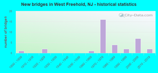
- New bridges - historical statistics
- 11900-1909
- 21920-1929
- 11960-1969
- 161970-1979
- 41980-1989
- 21990-1999
- 72000-2009
- 22010-2019


- Bridge Condition - Deck
- 5.0%Very good
- 45.0%Good
- 40.0%Satisfactory
- 10.0%Fair

- Bridge Condition - Superstructure
- 31.8%Very good
- 27.3%Good
- 27.3%Satisfactory
- 9.1%Fair
- 4.5%Poor

- Bridge Condition - Substructure
- 13.6%Very good
- 63.6%Good
- 13.6%Satisfactory
- 4.5%Fair
- 4.5%Poor

- Bridge Condition - Channel
- 8.3%Very good
- 16.7%Good
- 41.7%Satisfactory
- 33.3%Fair
Find on map >> Show street view
Structure Number: 1300F3, Location: 0.25 MI E OF US 9 JCT (Lat: 40.220411, Lng: -74.261861), Route carried "on" structure: County highway 524, Year Built: 1900, Status: Open, Structure Length: 1.37m (4.49ft), Average Daily Traffic: 9,954 (year 2021), Truck Traffic: 4%, Average Future Daily Traffic: 12,146 (year 2041), Features Intersected: APPLEGATES CREEK
Minimum Vertical Clearance: 30+ m (98+ ft), Kilometerpoint: 41.038, Lanes on structure: 2, Owner: County Highway Agency, Approaching Roadway Width: 10.1m (33.1ft), Material/Design: Concrete, Design/Construction: Arch - Deck, Number Of Spans In Main Unit: 1, Length of Maximum Span: 9.1m (29.9ft), Curb-To-Curb Width: 7.6m (24.9ft), Out-to-Out Width: 9.1m (29.9ft)
Condition: Superstructure: Fair, Substructure: Satisfactory, Channel: Fair, Operating Rating: 46.3 metric tons, Method Used To Determine Operating Rating: Field evaluation and documented engineering judgment, Inventory Rating: 28.1 metric tons, Method Used To Determine Inventory Rating: Field evaluation and documented engineering judgment, Structural Evaluation: Somewhat better than minimum adequacy, Deck Geometry: High priority of replacement, Waterway Adequacy: Superior to present desirable criteria, Approach Roadway Alignment: Equal to present minimum criteria, Length Of Structure Improvement: 1.98m (6.50ft), Designated Inspection Frequency: Every 24 months, Other Special Inspection Frequency: Every 24 months, Inspection Date: May 2021, Other Special Inspection Date: May 2021, Bridge Improvement Cost: $1,013,000, Roadway Improvement Cost: $252,000, Total Project Cost: $1,833,000 ( Estimate for 2021)
Find on map >> Show street view
Structure Number: 1300F32, Location: 1 ML WEST OF US 9 JCT. (Lat: 40.220919, Lng: -74.288250), Route carried "on" structure: County highway 524, Year Built: 1968, Status: Open, Structure Length: 0.67m (2.20ft), Average Daily Traffic: 9,954 (year 2021), Truck Traffic: 4%, Average Future Daily Traffic: 12,146 (year 2041), Features Intersected: BR OF MANASQUAN RIVER
Minimum Vertical Clearance: 30+ m (98+ ft), Kilometerpoint: 39.493, Lanes on structure: 2, Owner: County Highway Agency, Approaching Roadway Width: 12.2m (40.0ft), Material/Design: Concrete, Design/Construction: Slab, Number Of Spans In Main Unit: 1, Length of Maximum Span: 6.1m (20.0ft), Curb or Sidewalk Widths: Left: 3.3m (10.8ft), Right: 3.1m (10.2ft), Curb-To-Curb Width: 12.5m (41.0ft), Out-to-Out Width: 19.5m (64.0ft)
Condition: Deck: Good, Superstructure: Good, Substructure: Good, Channel: Fair, Operating Rating: 51.7 metric tons, Method Used To Determine Operating Rating: Load Factor (LF), Inventory Rating: 30.8 metric tons, Method Used To Determine Inventory Rating: Load Factor (LF), Structural Evaluation: Better than present minimum criteria, Deck Geometry: Somewhat better than minimum adequacy, Waterway Adequacy: Equal to present minimum criteria, Approach Roadway Alignment: Equal to present desirable criteria, Designated Inspection Frequency: Every 24 months, Inspection Date: May 2021, Deck Structure Type: Concrete Cast-file-Place, Wearing Surface/Protective System: Wearing Surface: Bituminous
Find on map >> Show street view
Structure Number: 1300F35, Location: 0.19 mile north of RT 524 (Lat: 40.221150, Lng: -74.313550), Route carried "on" structure: ServiceCity street , Year Built: 1998, Status: Open, Structure Length: 0.76m (2.49ft), Average Daily Traffic: 2,447 (year 2021), Truck Traffic: 3%, Average Future Daily Traffic: 2,986 (year 2041), Design Load: HS 20, Features Intersected: Manasquan River-Trib., Facility Carried by Structure: Iron Bridge Road
Minimum Vertical Clearance: 30+ m (98+ ft), Kilometerpoint: 0.306, Lanes on structure: 2, Owner: County Highway Agency, Approaching Roadway Width: 11.9m (39.0ft), Material/Design: Concrete, Design/Construction: Culvert, Number Of Spans In Main Unit: 2, Length of Maximum Span: 3.7m (12.1ft), Curb or Sidewalk Widths: Left: 1.2m (3.9ft), Right: 1.2m (3.9ft), Curb-To-Curb Width: 12.1m (39.7ft), Out-to-Out Width: 21.2m (69.6ft)
Condition: Channel: Satisfactory, Culverts: Good, Operating Rating: 54.4 metric tons, Method Used To Determine Operating Rating: Field evaluation and documented engineering judgment, Inventory Rating: 32.7 metric tons, Method Used To Determine Inventory Rating: Field evaluation and documented engineering judgment, Structural Evaluation: Better than present minimum criteria, Deck Geometry: Somewhat better than minimum adequacy, Waterway Adequacy: Better than present minimum criteria, Approach Roadway Alignment: Better than present minimum criteria, Designated Inspection Frequency: Every 24 months, Inspection Date: May 2021, Wearing Surface/Protective System: Wearing Surface: Monolithic Concrete
Find on map >> Show street view
Structure Number: 1300F45, Location: 0.63mi S OF INT W RT 524 (Lat: 40.211669, Lng: -74.295561), Route carried "on" structure: City street , Year Built: 2002, Status: Open, Structure Length: 1.07m (3.51ft), Average Daily Traffic: 1,631 (year 2021), Truck Traffic: 3%, Average Future Daily Traffic: 1,991 (year 2041), Design Load: HS 20, Features Intersected: MANASQUAN RIVER, Facility Carried by Structure: GEORGIA ROAD
Minimum Vertical Clearance: 30+ m (98+ ft), Kilometerpoint: 0.000, Lanes on structure: 2, Owner: County Highway Agency, Approaching Roadway Width: 12.2m (40.0ft), Material/Design: Concrete, Design/Construction: Arch - Deck, Number Of Spans In Main Unit: 1, Length of Maximum Span: 10.7m (35.1ft), Curb or Sidewalk Widths: Left: 1.5m (4.9ft), Right: 1.8m (5.9ft), Curb-To-Curb Width: 12.2m (40.0ft), Out-to-Out Width: 15.8m (51.8ft)
Condition: Superstructure: Very good, Substructure: Good, Channel: Satisfactory, Operating Rating: 54.4 metric tons, Method Used To Determine Operating Rating: Field evaluation and documented engineering judgment, Inventory Rating: 32.7 metric tons, Method Used To Determine Inventory Rating: Field evaluation and documented engineering judgment, Structural Evaluation: Better than present minimum criteria, Deck Geometry: Better than present minimum criteria, Waterway Adequacy: Better than present minimum criteria, Approach Roadway Alignment: Equal to present desirable criteria, Designated Inspection Frequency: Every 24 months, Inspection Date: May 2021, Wearing Surface/Protective System: Wearing Surface: Bituminous
Find on map >> Show street view
Structure Number: 1300F51, Location: 1 MILE WEST OF US 9 (Lat: 40.210281, Lng: -74.277500), Route carried "on" structure: County highway 23, Year Built: 1929, Status: Open, Structure Length: 1.04m (3.41ft), Average Daily Traffic: 12,946 (year 2021), Truck Traffic: 3%, Average Future Daily Traffic: 15,797 (year 2041), Features Intersected: MANASQUAN RIVER, Facility Carried by Structure: JACKSON MILLS ROAD
Minimum Vertical Clearance: 30+ m (98+ ft), Kilometerpoint: 4.925, Lanes on structure: 2, Owner: County Highway Agency, Approaching Roadway Width: 7.9m (25.9ft), Material/Design: Steel, Design/Construction: Stringer/Multi-beam, Number Of Spans In Main Unit: 1, Length of Maximum Span: 8.8m (28.9ft), Curb-To-Curb Width: 7.9m (25.9ft), Out-to-Out Width: 9.1m (29.9ft)
Condition: Deck: Fair, Superstructure: Fair, Substructure: Fair, Channel: Satisfactory, Operating Rating: 52.6 metric tons, Method Used To Determine Operating Rating: Load Factor (LF), Inventory Rating: 31.8 metric tons, Method Used To Determine Inventory Rating: Load Factor (LF), Structural Evaluation: Somewhat better than minimum adequacy, Deck Geometry: High priority of replacement, Waterway Adequacy: Superior to present desirable criteria, Approach Roadway Alignment: Better than present minimum criteria, Length Of Structure Improvement: 1.68m (5.51ft), Designated Inspection Frequency: Every 24 months, Inspection Date: May 2021, Bridge Improvement Cost: $1,554,000, Roadway Improvement Cost: $233,000, Total Project Cost: $2,331,000 ( Estimate for 2021), Deck Structure Type: Concrete Cast-file-Place, Wearing Surface/Protective System: Wearing Surface: Bituminous
Find on map >> Show street view
Structure Number: 1300HL8, Location: 0.6 MILE SOUTH OF RT 524 (Lat: 40.204989, Lng: -74.238969), Route carried "on" structure: Other road , Year Built: 2015, Status: Open, Structure Length: 2.87m (9.42ft), Average Daily Traffic: 1,220 (year 2021), Truck Traffic: 3%, Average Future Daily Traffic: 1,489 (year 2041), Design Load: HL 93, Features Intersected: MANASQUAN RIVER, Facility Carried by Structure: HAVENS BRIDGE ROAD
Minimum Vertical Clearance: 30+ m (98+ ft), Kilometerpoint: 0.000, Lanes on structure: 2, Owner: County Highway Agency, Approaching Roadway Width: 9.1m (29.9ft), Material/Design: Prestressed concrete, Design/Construction: Box Beam or Girders - Multiple, Number Of Spans In Main Unit: 4, Length of Maximum Span: 9.1m (29.9ft), Curb or Sidewalk Widths: Left: 1.5m (4.9ft), Right: 0.3m (1.0ft), Curb-To-Curb Width: 9.1m (29.9ft), Out-to-Out Width: 12.2m (40.0ft)
Condition: Deck: Good, Superstructure: Very good, Substructure: Very good, Channel: Good, Operating Rating: 96.9 metric tons, Method Used To Determine Operating Rating: Load and Resistance Factor Rating (LRFR) rating reported by rating factor(RF) method using HL-93 loadings, Inventory Rating: 74.5 metric tons, Method Used To Determine Inventory Rating: Load and Resistance Factor Rating (LRFR) rating reported by rating factor(RF) method using HL-93 loadings, Structural Evaluation: Equal to present desirable criteria, Deck Geometry: Somewhat better than minimum adequacy, Waterway Adequacy: Better than present minimum criteria, Approach Roadway Alignment: Equal to present minimum criteria, Length Of Structure Improvement: 2.80m (9.19ft), Designated Inspection Frequency: Every 24 months, Inspection Date: April 2021, Bridge Improvement Cost: $41,000, Roadway Improvement Cost: $4,000, Total Project Cost: $58,000, Deck Structure Type: Concrete Precast Panels, Wearing Surface/Protective System: Wearing Surface: Monolithic Concrete
Find on map >> Show street view
Structure Number: 130115, Location: 1.0MI. SO. OF CO. RT. 524 (Lat: 40.204439, Lng: -74.255989), Route carried "on" structure: US 9, Year Built: 1974, Status: Open, Structure Length: 1.98m (6.50ft), Average Daily Traffic: 50,463 (year 2020), Truck Traffic: 4%, Average Future Daily Traffic: 55,742 (year 2040), Design Load: HS 20, Features Intersected: MANASQUAN RIVER
Minimum Vertical Clearance: 30+ m (98+ ft), Kilometerpoint: 177.076, Lanes on structure: 5, Base Highway Network: Yes, Owner: State Highway Agency, Approaching Roadway Width: 25.3m (83.0ft), Skew: 31 degrees, Material/Design: Prestressed concrete, Design/Construction: Box Beam or Girders - Multiple, Number Of Spans In Main Unit: 1, Length of Maximum Span: 19.2m (63.0ft), Curb or Sidewalk Widths: Left: 1.8m (5.9ft), Right: 1.8m (5.9ft), Curb-To-Curb Width: 25.3m (83.0ft), Out-to-Out Width: 30.5m (100.1ft)
Condition: Deck: Fair, Superstructure: Satisfactory, Substructure: Satisfactory, Channel: Fair, Operating Rating: 45.4 metric tons, Method Used To Determine Operating Rating: Load Factor (LF), Inventory Rating: 23.6 metric tons, Method Used To Determine Inventory Rating: Load Factor (LF), Structural Evaluation: Somewhat better than minimum adequacy, Deck Geometry: Superior to present desirable criteria, Waterway Adequacy: Superior to present desirable criteria, Approach Roadway Alignment: Equal to present desirable criteria, Designated Inspection Frequency: Every 24 months, Inspection Date: March 2020, Deck Structure Type: Concrete Cast-file-Place, Wearing Surface/Protective System: Wearing Surface: Bituminous, Membrane: Epoxy
Find on map >> Show street view
Structure Number: 1301151, Location: 1.86 MI S OF NJ 33F JCT (Lat: 40.217939, Lng: -74.263531), Route carried "on" structure: US 9, Year Built: 1973, Status: Open, Structure Length: 1.07m (3.51ft), Average Daily Traffic: 54,146 (year 2021), Truck Traffic: 4%, Average Future Daily Traffic: 66,068 (year 2041), Design Load: HS 20, Features Intersected: DEBOIS CREEK
Minimum Vertical Clearance: 30+ m (98+ ft), Kilometerpoint: 178.718, Lanes on structure: 4, Base Highway Network: Yes, Owner: State Highway Agency, Approaching Roadway Width: 25.3m (83.0ft), Skew: 22 degrees, Material/Design: Concrete, Design/Construction: Culvert, Number Of Spans In Main Unit: 2, Length of Maximum Span: 5.2m (17.1ft)
Condition: Channel: Fair, Culverts: Good, Inventory Rating: 57.2 metric tons, Method Used To Determine Inventory Rating: Load Factor (LF), Structural Evaluation: Better than present minimum criteria, Waterway Adequacy: Superior to present desirable criteria, Approach Roadway Alignment: Equal to present desirable criteria, Designated Inspection Frequency: Every 24 months, Inspection Date: June 2021
Find on map >> Show street view
Structure Number: 1304156, Location: 0.42 MI W OF CR 527 JCT (Lat: 40.253131, Lng: -74.349669), Route carried "on" structure: State highway 33, Year Built: 1927, Year Reconstructed: 1966, Status: Open, Structure Length: 1.13m (3.71ft), Average Daily Traffic: 29,357 (year 2021), Truck Traffic: 4%, Average Future Daily Traffic: 35,821 (year 2041), Design Load: HS 20, Features Intersected: MANALAPAN BROOK
Minimum Vertical Clearance: 30+ m (98+ ft), Kilometerpoint: 37.964, Lanes on structure: 4, Base Highway Network: Yes, Owner: State Highway Agency, Approaching Roadway Width: 23.2m (76.1ft), Skew: 23 degrees, Material/Design: Steel, Design/Construction: Stringer/Multi-beam, Number Of Spans In Main Unit: 1, Length of Maximum Span: 10.1m (33.1ft), Curb or Sidewalk Widths: Left: 1.8m (5.9ft), Right: 0.0m, Curb-To-Curb Width: 30.5m (100.1ft), Out-to-Out Width: 33.1m (108.6ft)
Condition: Deck: Satisfactory, Superstructure: Poor, Substructure: Poor, Channel: Good, Operating Rating: 59.9 metric tons, Method Used To Determine Operating Rating: Load Factor (LF), Inventory Rating: 36.3 metric tons, Method Used To Determine Inventory Rating: Load Factor (LF), Structural Evaluation: Meets minimum limits, Deck Geometry: Superior to present desirable criteria, Waterway Adequacy: Superior to present desirable criteria, Approach Roadway Alignment: Equal to present desirable criteria, Length Of Structure Improvement: 1.80m (5.91ft), Designated Inspection Frequency: Every 24 months, Inspection Date: May 2021, Bridge Improvement Cost: $2,249,000, Roadway Improvement Cost: $179,000, Total Project Cost: $3,600,000 ( Estimate for 2021), Deck Structure Type: Concrete Cast-file-Place, Wearing Surface/Protective System: Wearing Surface: Bituminous
Find on map >> Show street view
Structure Number: 1305162, Location: 2.1 MI EAST OF NJ 79 JCT (Lat: 40.234889, Lng: -74.237761), Route carried "on" structure: State highway 33, Year Built: 2002, Status: Open, Structure Length: 4.39m (14.40ft), Average Daily Traffic: 18,270 (year 2021), Truck Traffic: 5%, Average Future Daily Traffic: 22,293 (year 2041), Design Load: HL 93, Features Intersected: NJ TRANSIT (ABANDONED)
Minimum Vertical Clearance: 30+ m (98+ ft), Kilometerpoint: 47.926, Lanes on structure: 2, Base Highway Network: Yes, Owner: State Highway Agency, Approaching Roadway Width: 16.8m (55.1ft), Skew: 15 degrees, Material/Design: Steel, Design/Construction: Stringer/Multi-beam, Number Of Spans In Main Unit: 1, Length of Maximum Span: 42.4m (139.1ft), Curb-To-Curb Width: 16.8m (55.1ft), Out-to-Out Width: 18.9m (62.0ft)
Condition: Deck: Good, Superstructure: Very good, Substructure: Good, Operating Rating: 67.7 metric tons, Method Used To Determine Operating Rating: Load and Resistance Factor Rating (LRFR) rating reported by rating factor(RF) method using HL-93 loadings, Inventory Rating: 52.8 metric tons, Method Used To Determine Inventory Rating: Load and Resistance Factor Rating (LRFR) rating reported by rating factor(RF) method using HL-93 loadings, Structural Evaluation: Better than present minimum criteria, Deck Geometry: Superior to present desirable criteria, Underclear: Superior to present desirable criteria, Approach Roadway Alignment: Better than present minimum criteria, Designated Inspection Frequency: Every 24 months, Inspection Date: March 2021, Deck Structure Type: Concrete Cast-file-Place, Wearing Surface/Protective System: Wearing Surface: Monolithic Concrete, Deck Protection: Epoxy Coated Reinforcing
Find on map >> Show street view
Structure Number: 1305163, Location: 1.5 MI NORTH OF CR524 (Lat: 40.234369, Lng: -74.232589), Route carried "on" structure: City street , Year Built: 2001, Status: Open, Structure Length: 4.42m (14.50ft), Average Daily Traffic: 8,421 (year 2020), Truck Traffic: 1%, Average Future Daily Traffic: 10,105 (year 2040), Design Load: HL 93, Features Intersected: NJ 33, Facility Carried by Structure: HOWELL ROAD
Minimum Vertical Clearance: 30+ m (98+ ft), Kilometerpoint: 5.230, Lanes on structure: 2, Lanes under structure: 2, Owner: State Highway Agency, Approaching Roadway Width: 16.8m (55.1ft), Skew: 2 degrees, Material/Design: Steel continuous, Design/Construction: Stringer/Multi-beam, Number Of Spans In Main Unit: 2, Length of Maximum Span: 21.0m (68.9ft), Curb or Sidewalk Widths: Left: 0.0m, Right: 1.8m (5.9ft), Curb-To-Curb Width: 16.8m (55.1ft), Out-to-Out Width: 19.4m (63.6ft)
Condition: Deck: Good, Superstructure: Very good, Substructure: Good, Operating Rating: 59.6 metric tons, Method Used To Determine Operating Rating: Load and Resistance Factor Rating (LRFR) rating reported by rating factor(RF) method using HL-93 loadings, Inventory Rating: 46.0 metric tons, Method Used To Determine Inventory Rating: Load and Resistance Factor Rating (LRFR) rating reported by rating factor(RF) method using HL-93 loadings, Structural Evaluation: Better than present minimum criteria, Deck Geometry: Superior to present desirable criteria, Underclear: Equal to present minimum criteria, Approach Roadway Alignment: Equal to present minimum criteria, Designated Inspection Frequency: Every 24 months, Inspection Date: July 2020, Deck Structure Type: Concrete Cast-file-Place, Wearing Surface/Protective System: Wearing Surface: Monolithic Concrete, Deck Protection: Epoxy Coated Reinforcing
Find on map >> Show street view
Structure Number: 1305166, Location: 0.41 Mile E of Halls Mill (Lat: 40.236339, Lng: -74.244839), Route carried "on" structure: State highway 33, Year Built: 2003, Status: Open, Structure Length: 12.28m (40.29ft), Average Daily Traffic: 20,349 (year 2021), Truck Traffic: 5%, Average Future Daily Traffic: 24,419 (year 2041), Design Load: HL 93, Features Intersected: BURKES CREEK
Minimum Vertical Clearance: 30+ m (98+ ft), Kilometerpoint: 47.347, Lanes on structure: 2, Base Highway Network: Yes, Owner: State Highway Agency, Approaching Roadway Width: 18.6m (61.0ft), Skew: 30 degrees, Material/Design: Steel continuous, Design/Construction: Stringer/Multi-beam, Number Of Spans In Main Unit: 3, Length of Maximum Span: 50.3m (165.0ft), Curb-To-Curb Width: 28.4m (93.2ft), Out-to-Out Width: 30.3m (99.4ft)
Condition: Deck: Good, Superstructure: Very good, Substructure: Very good, Channel: Very good, Operating Rating: 43.4 metric tons, Method Used To Determine Operating Rating: Load and Resistance Factor Rating (LRFR) rating reported by rating factor(RF) method using HL-93 loadings, Inventory Rating: 33.0 metric tons, Method Used To Determine Inventory Rating: Load and Resistance Factor Rating (LRFR) rating reported by rating factor(RF) method using HL-93 loadings, Structural Evaluation: Equal to present desirable criteria, Deck Geometry: Superior to present desirable criteria, Waterway Adequacy: Superior to present desirable criteria, Approach Roadway Alignment: Equal to present desirable criteria, Designated Inspection Frequency: Every 24 months, Inspection Date: May 2021, Deck Structure Type: Concrete Cast-file-Place, Wearing Surface/Protective System: Wearing Surface: Monolithic Concrete, Deck Protection: Epoxy Coated Reinforcing
Find on map >> Show street view
Structure Number: 130HL13, Location: .5 MI E OF CO RT 23 (Lat: 40.209081, Lng: -74.268550), Route carried "on" structure: City street , Year Built: 1991, Status: Open, Structure Length: 0.94m (3.08ft), Average Daily Traffic: 5,120 (year 2021), Truck Traffic: 1%, Average Future Daily Traffic: 6,130 (year 2041), Design Load: HS 20+Mod, Features Intersected: DEBOIS CREEK, Facility Carried by Structure: STRICKLAND ROAD
Minimum Vertical Clearance: 30+ m (98+ ft), Kilometerpoint: 0.756, Lanes on structure: 2, Owner: County Highway Agency, Approaching Roadway Width: 12.2m (40.0ft), Material/Design: Concrete continuous, Design/Construction: Slab, Number Of Spans In Main Unit: 2, Length of Maximum Span: 4.6m (15.1ft), Curb or Sidewalk Widths: Left: 1.5m (4.9ft), Right: 0.2m (0.7ft), Curb-To-Curb Width: 12.2m (40.0ft), Out-to-Out Width: 14.6m (47.9ft)
Condition: Deck: Satisfactory, Superstructure: Satisfactory, Substructure: Good, Channel: Satisfactory, Operating Rating: 64.4 metric tons, Method Used To Determine Operating Rating: Load Factor (LF), Inventory Rating: 38.1 metric tons, Method Used To Determine Inventory Rating: Load Factor (LF), Structural Evaluation: Equal to present minimum criteria, Deck Geometry: Somewhat better than minimum adequacy, Waterway Adequacy: Better than present minimum criteria, Approach Roadway Alignment: Equal to present desirable criteria, Designated Inspection Frequency: Every 24 months, Inspection Date: April 2021, Deck Structure Type: Concrete Cast-file-Place, Wearing Surface/Protective System: Wearing Surface: Monolithic Concrete, Deck Protection: Epoxy Coated Reinforcing
Find on map >> Show street view
Structure Number: 130MN1, Location: 0.35 MILE SOUTH OF NJ 33 (Lat: 40.248569, Lng: -74.342700), Route carried "on" structure: County highway 527, Year Built: 2011, Status: Open, Structure Length: 0.94m (3.08ft), Average Daily Traffic: 10,438 (year 2021), Truck Traffic: 3%, Average Future Daily Traffic: 12,736 (year 2041), Design Load: HS 25 or greater, Features Intersected: MANALAPAN BROOK, Facility Carried by Structure: SWEETMANS LANE
Minimum Vertical Clearance: 30+ m (98+ ft), Kilometerpoint: 42.261, Lanes on structure: 2, Owner: County Highway Agency, Approaching Roadway Width: 9.1m (29.9ft), Material/Design: Prestressed concrete, Design/Construction: Stringer/Multi-beam, Number Of Spans In Main Unit: 1, Length of Maximum Span: 7.9m (25.9ft), Curb or Sidewalk Widths: Left: 0.5m (1.6ft), Right: 1.8m (5.9ft), Curb-To-Curb Width: 9.1m (29.9ft), Out-to-Out Width: 12.5m (41.0ft)
Condition: Deck: Good, Superstructure: Very good, Substructure: Good, Channel: Satisfactory, Operating Rating: 46.3 metric tons, Method Used To Determine Operating Rating: Load Factor (LF), Inventory Rating: 29.0 metric tons, Method Used To Determine Inventory Rating: Load Factor (LF), Structural Evaluation: Better than present minimum criteria, Deck Geometry: High priority of corrective action, Waterway Adequacy: Superior to present desirable criteria, Approach Roadway Alignment: Equal to present minimum criteria, Length Of Structure Improvement: 0.94m (3.08ft), Designated Inspection Frequency: Every 24 months, Inspection Date: May 2021, Bridge Improvement Cost: $39,000, Roadway Improvement Cost: $17,000, Total Project Cost: $103,000 ( Estimate for 2021), Deck Structure Type: Concrete Cast-file-Place, Wearing Surface/Protective System: Wearing Surface: Monolithic Concrete, Deck Protection: Galvanized Reinforcing
Find on map >> Show street view
Structure Number: 133115, Location: 0.67 MI E OF CR 527 JCT (Lat: 40.253339, Lng: -74.329489), Route carried "on" structure: Ramp State highway 33, Year Built: 1974, Status: Open, Structure Length: 6.86m (22.51ft), Average Daily Traffic: 4,930 (year 2021), Truck Traffic: 4%, Average Future Daily Traffic: 6,015 (year 2041), Design Load: HS 20+Mod, Features Intersected: NJ 33 FREEWAY, Facility Carried by Structure: RAMP "W"
Minimum Vertical Clearance: 30+ m (98+ ft), Kilometerpoint: 39.719, Lanes on structure: 2, Lanes under structure: 4, Owner: State Highway Agency, Approaching Roadway Width: 6.7m (22.0ft), Skew: 4 degrees, Material/Design: Steel, Design/Construction: Stringer/Multi-beam, Number Of Spans In Main Unit: 2, Length of Maximum Span: 36.0m (118.1ft), Curb or Sidewalk Widths: Left: 0.8m (2.6ft), Right: 0.8m (2.6ft), Curb-To-Curb Width: 6.7m (22.0ft), Out-to-Out Width: 9.5m (31.2ft)
Condition: Deck: Satisfactory, Superstructure: Satisfactory, Substructure: Good, Operating Rating: 89.8 metric tons, Method Used To Determine Operating Rating: Load Factor (LF), Inventory Rating: 53.5 metric tons, Method Used To Determine Inventory Rating: Load Factor (LF), Structural Evaluation: Equal to present minimum criteria, Deck Geometry: High priority of replacement, Underclear: High priority of corrective action, Approach Roadway Alignment: Equal to present minimum criteria, Length Of Structure Improvement: 6.86m (22.51ft), Designated Inspection Frequency: Every 24 months, Inspection Date: December 2021, Bridge Improvement Cost: $621,000, Roadway Improvement Cost: $110,000, Total Project Cost: $948,000 ( Estimate for 2021), Deck Structure Type: Concrete Cast-file-Place, Wearing Surface/Protective System: Wearing Surface: Monolithic Concrete
Find on map >> Show street view
Structure Number: 1331151, Location: 0.91 MI WEST OF RT 537 (Lat: 40.251011, Lng: -74.310839), Route carried "on" structure: Other road , Year Built: 1974, Status: Open, Structure Length: 8.38m (27.49ft), Average Daily Traffic: 3,948 (year 2019), Truck Traffic: 1%, Average Future Daily Traffic: 4,738 (year 2039), Design Load: HS 20, Features Intersected: RT 33 FREEWAY, Facility Carried by Structure: WEMROCK ROAD
Minimum Vertical Clearance: 30+ m (98+ ft), Kilometerpoint: 0.354, Lanes on structure: 3, Lanes under structure: 6, Owner: State Highway Agency, Approaching Roadway Width: 15.2m (49.9ft), Skew: 4 degrees, Material/Design: Steel, Design/Construction: Stringer/Multi-beam, Number Of Spans In Main Unit: 2, Length of Maximum Span: 41.1m (134.8ft), Curb or Sidewalk Widths: Left: 0.5m (1.6ft), Right: 1.8m (5.9ft), Curb-To-Curb Width: 15.2m (49.9ft), Out-to-Out Width: 18.8m (61.7ft)
Condition: Deck: Satisfactory, Superstructure: Good, Substructure: Satisfactory, Inventory Rating: 54.4 metric tons, Method Used To Determine Inventory Rating: Load Factor (LF), Structural Evaluation: Equal to present minimum criteria, Deck Geometry: Equal to present minimum criteria, Underclear: High priority of corrective action, Approach Roadway Alignment: Equal to present minimum criteria, Length Of Structure Improvement: 8.38m (27.49ft), Designated Inspection Frequency: Every 24 months, Inspection Date: June 2021, Bridge Improvement Cost: $1,208,000, Total Project Cost: $1,208,000 ( Estimate for 2019), Deck Structure Type: Concrete Cast-file-Place, Wearing Surface/Protective System: Wearing Surface: Monolithic Concrete
Find on map >> Show street view
Structure Number: 1331152, Location: 0.95 MI WEST OF US 9 (Lat: 40.246711, Lng: -74.294489), Route carried "on" structure: County highway 537, Year Built: 1974, Status: Open, Structure Length: 5.91m (19.39ft), Average Daily Traffic: 15,464 (year 2021), Truck Traffic: 4%, Average Future Daily Traffic: 18,869 (year 2041), Design Load: HS 20+Mod, Features Intersected: NJ 33 FREEWAY
Minimum Vertical Clearance: 30+ m (98+ ft), Kilometerpoint: 81.787, Lanes on structure: 4, Lanes under structure: 6, Owner: State Highway Agency, Approaching Roadway Width: 15.2m (49.9ft), Skew: 1 degrees, Material/Design: Steel, Design/Construction: Stringer/Multi-beam, Number Of Spans In Main Unit: 2, Length of Maximum Span: 29.0m (95.1ft), Curb or Sidewalk Widths: Left: 0.5m (1.6ft), Right: 1.8m (5.9ft), Curb-To-Curb Width: 15.2m (49.9ft), Out-to-Out Width: 18.8m (61.7ft)
Condition: Deck: Satisfactory, Superstructure: Good, Substructure: Good, Inventory Rating: 71.7 metric tons, Method Used To Determine Inventory Rating: Load Factor (LF), Structural Evaluation: Better than present minimum criteria, Deck Geometry: High priority of corrective action, Underclear: High priority of corrective action, Approach Roadway Alignment: Equal to present desirable criteria, Length Of Structure Improvement: 5.91m (19.39ft), Designated Inspection Frequency: Every 24 months, Inspection Date: December 2021, Bridge Improvement Cost: $1,070,000, Roadway Improvement Cost: $161,000, Total Project Cost: $1,538,000 ( Estimate for 2021), Deck Structure Type: Concrete Cast-file-Place, Wearing Surface/Protective System: Wearing Surface: Monolithic Concrete
Find on map >> Show street view
Structure Number: 1331153, Location: 0.2 MI WEST OF RT 79 (Lat: 40.241800, Lng: -74.278500), Route carried "on" structure: State highway 33F, Year Built: 1974, Status: Open, Structure Length: 6.86m (22.51ft), Average Daily Traffic: 14,550 (year 2020), Truck Traffic: 5%, Average Future Daily Traffic: 17,750 (year 2040), Design Load: HS 20, Features Intersected: US 9, Facility Carried by Structure: RT NJ 33 FRWY WB
Minimum Vertical Clearance: 30+ m (98+ ft), Kilometerpoint: 44.321, Lanes on structure: 3, Lanes under structure: 4, Base Highway Network: Yes, Owner: State Highway Agency, Approaching Roadway Width: 16.2m (53.1ft), Skew: 4 degrees, Material/Design: Steel, Design/Construction: Stringer/Multi-beam, Number Of Spans In Main Unit: 2, Length of Maximum Span: 34.4m (112.9ft), Curb or Sidewalk Widths: Left: 0.2m (0.7ft), Right: 0.2m (0.7ft), Curb-To-Curb Width: 16.2m (53.1ft), Out-to-Out Width: 17.8m (58.4ft)
Condition: Deck: Satisfactory, Superstructure: Good, Substructure: Good, Inventory Rating: 61.7 metric tons, Method Used To Determine Inventory Rating: Load Factor (LF), Structural Evaluation: Better than present minimum criteria, Deck Geometry: Equal to present minimum criteria, Underclear: Equal to present minimum criteria, Approach Roadway Alignment: Equal to present desirable criteria, Designated Inspection Frequency: Every 24 months, Inspection Date: Febuary 2020, Deck Structure Type: Concrete Cast-file-Place, Wearing Surface/Protective System: Deck Protection: Other
Find on map >> Show street view
Structure Number: 1331154, Location: 1 MILE EAST OF CO 537 JCT (Lat: 40.241861, Lng: -74.278769), Route carried "on" structure: State highway 33, Year Built: 1974, Status: Open, Structure Length: 6.89m (22.60ft), Average Daily Traffic: 14,040 (year 2020), Truck Traffic: 5%, Average Future Daily Traffic: 17,130 (year 2040), Design Load: HS 20, Features Intersected: US 9
Minimum Vertical Clearance: 30+ m (98+ ft), Kilometerpoint: 44.321, Lanes on structure: 2, Lanes under structure: 4, Base Highway Network: Yes, Owner: State Highway Agency, Approaching Roadway Width: 12.8m (42.0ft), Skew: 4 degrees, Material/Design: Steel, Design/Construction: Stringer/Multi-beam, Number Of Spans In Main Unit: 2, Length of Maximum Span: 33.2m (108.9ft), Curb or Sidewalk Widths: Left: 0.0m, Right: 0.2m (0.7ft), Curb-To-Curb Width: 13.0m (42.7ft), Out-to-Out Width: 14.7m (48.2ft)
Condition: Deck: Satisfactory, Superstructure: Good, Substructure: Good, Inventory Rating: 61.7 metric tons, Method Used To Determine Inventory Rating: Load Factor (LF), Structural Evaluation: Better than present minimum criteria, Deck Geometry: Superior to present desirable criteria, Underclear: Somewhat better than minimum adequacy, Approach Roadway Alignment: Equal to present desirable criteria, Designated Inspection Frequency: Every 24 months, Inspection Date: August 2020, Deck Structure Type: Concrete Cast-file-Place, Wearing Surface/Protective System: Wearing Surface: Monolithic Concrete
Find on map >> Show street view
Structure Number: 133215, Location: 0.2MI EAST OF US9 (Lat: 40.241881, Lng: -74.274931), Route carried "on" structure: State highway 33, Year Built: 1974, Status: Open, Structure Length: 3.51m (11.52ft), Average Daily Traffic: 14,463 (year 2021), Truck Traffic: 5%, Average Future Daily Traffic: 17,664 (year 2041), Design Load: HS 20, Features Intersected: NJ ROUTE 79
Minimum Vertical Clearance: 30+ m (98+ ft), Kilometerpoint: 44.563, Lanes on structure: 3, Lanes under structure: 4, Base Highway Network: Yes, Owner: State Highway Agency, Approaching Roadway Width: 17.7m (58.1ft), Material/Design: Steel, Design/Construction: Stringer/Multi-beam, Number Of Spans In Main Unit: 1, Length of Maximum Span: 33.5m (109.9ft), Curb or Sidewalk Widths: Left: 0.2m (0.7ft), Right: 0.2m (0.7ft), Curb-To-Curb Width: 18.5m (60.7ft), Out-to-Out Width: 20.3m (66.6ft)
Condition: Deck: Satisfactory, Superstructure: Satisfactory, Substructure: Good, Operating Rating: 71.7 metric tons, Method Used To Determine Operating Rating: Load Factor (LF), Inventory Rating: 42.6 metric tons, Method Used To Determine Inventory Rating: Load Factor (LF), Structural Evaluation: Equal to present minimum criteria, Deck Geometry: Superior to present desirable criteria, Underclear: Meets minimum limits, Approach Roadway Alignment: Equal to present desirable criteria, Designated Inspection Frequency: Every 24 months, Inspection Date: April 2021, Deck Structure Type: Concrete Cast-file-Place, Wearing Surface/Protective System: Wearing Surface: Monolithic Concrete
Find on map >> Show street view
Structure Number: 1332151, Location: 0.2 MI EAST OF US 9 (Lat: 40.241561, Lng: -74.275439), Route carried "on" structure: State highway 33, Year Built: 1974, Status: Open, Structure Length: 3.44m (11.29ft), Average Daily Traffic: 13,396 (year 2021), Truck Traffic: 4%, Average Future Daily Traffic: 16,361 (year 2041), Design Load: HS 20+Mod, Features Intersected: NJ 79
Minimum Vertical Clearance: 30+ m (98+ ft), Kilometerpoint: 44.563, Lanes on structure: 2, Lanes under structure: 3, Base Highway Network: Yes, Owner: State Highway Agency, Approaching Roadway Width: 17.4m (57.1ft), Material/Design: Steel, Design/Construction: Stringer/Multi-beam, Number Of Spans In Main Unit: 1, Length of Maximum Span: 33.5m (109.9ft), Curb or Sidewalk Widths: Left: 0.2m (0.7ft), Right: 0.2m (0.7ft), Curb-To-Curb Width: 18.8m (61.7ft), Out-to-Out Width: 20.1m (65.9ft)
Condition: Deck: Good, Superstructure: Good, Substructure: Good, Operating Rating: 81.6 metric tons, Method Used To Determine Operating Rating: Load Factor (LF), Inventory Rating: 49.0 metric tons, Method Used To Determine Inventory Rating: Load Factor (LF), Structural Evaluation: Better than present minimum criteria, Deck Geometry: Superior to present desirable criteria, Underclear: Equal to present minimum criteria, Approach Roadway Alignment: Equal to present desirable criteria, Designated Inspection Frequency: Every 24 months, Inspection Date: April 2021, Deck Structure Type: Concrete Cast-file-Place, Wearing Surface/Protective System: Wearing Surface: Monolithic Concrete
Find on map >> Show street view
Structure Number: 1332153, Location: 0.7 MI EAST OF US 9 JCT (Lat: 40.241481, Lng: -74.264239), Route carried "on" structure: City street , Year Built: 1987, Status: Open, Structure Length: 8.72m (28.61ft), Average Daily Traffic: 2,310 (year 2021), Truck Traffic: 1%, Average Future Daily Traffic: 2,820 (year 2041), Design Load: HS 20, Features Intersected: NJ ROUTE 33, Facility Carried by Structure: WILLOW BROOK ROAD
Minimum Vertical Clearance: 30+ m (98+ ft), Kilometerpoint: 0.000, Lanes on structure: 2, Lanes under structure: 4, Owner: State Highway Agency, Approaching Roadway Width: 12.2m (40.0ft), Skew: 5 degrees, Material/Design: Steel, Design/Construction: Stringer/Multi-beam, Number Of Spans In Main Unit: 2, Length of Maximum Span: 43.3m (142.1ft), Curb or Sidewalk Widths: Left: 1.8m (5.9ft), Right: 0.0m, Curb-To-Curb Width: 12.2m (40.0ft), Out-to-Out Width: 14.9m (48.9ft)
Condition: Deck: Very good, Superstructure: Satisfactory, Substructure: Good, Operating Rating: 89.8 metric tons, Method Used To Determine Operating Rating: Load Factor (LF), Inventory Rating: 84.4 metric tons, Method Used To Determine Inventory Rating: Load Factor (LF), Structural Evaluation: Equal to present minimum criteria, Deck Geometry: Equal to present minimum criteria, Underclear: Equal to present minimum criteria, Approach Roadway Alignment: Equal to present desirable criteria, Designated Inspection Frequency: Every 24 months, Inspection Date: December 2021, Deck Structure Type: Concrete Cast-file-Place, Wearing Surface/Protective System: Wearing Surface: Monolithic Concrete, Deck Protection: Epoxy Coated Reinforcing
Find on map >> Show street view
Structure Number: 1332159, Location: 1.5 MILES EAST OF ROUTE 9 (Lat: 40.235950, Lng: -74.251169), Route carried "on" structure: Other road , Year Built: 1987, Status: Open, Structure Length: 5.94m (19.49ft), Average Daily Traffic: 13,540 (year 2021), Truck Traffic: 4%, Average Future Daily Traffic: 16,521 (year 2041), Design Load: HS 20+Mod, Features Intersected: N.J. ROUTE 33 FRWY., Facility Carried by Structure: HALLS MILL RD
Minimum Vertical Clearance: 30+ m (98+ ft), Kilometerpoint: 0.386, Lanes on structure: 6, Lanes under structure: 4, Owner: State Highway Agency, Approaching Roadway Width: 23.8m (78.1ft), Skew: 1 degrees, Material/Design: Steel, Design/Construction: Stringer/Multi-beam, Number Of Spans In Main Unit: 2, Length of Maximum Span: 29.0m (95.1ft), Curb or Sidewalk Widths: Left: 0.0m, Right: 1.8m (5.9ft), Curb-To-Curb Width: 23.8m (78.1ft), Out-to-Out Width: 26.5m (86.9ft)
Condition: Deck: Good, Superstructure: Satisfactory, Substructure: Good, Inventory Rating: 59.9 metric tons, Method Used To Determine Inventory Rating: Load Factor (LF), Structural Evaluation: Equal to present minimum criteria, Deck Geometry: Somewhat better than minimum adequacy, Underclear: Somewhat better than minimum adequacy, Approach Roadway Alignment: Equal to present desirable criteria, Designated Inspection Frequency: Every 24 months, Inspection Date: June 2021, Deck Structure Type: Concrete Cast-file-Place, Wearing Surface/Protective System: Wearing Surface: Monolithic Concrete, Deck Protection: Epoxy Coated Reinforcing
Find on map >> Show street view
Structure Number: 1336153, Location: 1.47 Mi East of NJ 79 Jct (Lat: 40.236081, Lng: -74.251200), Route carried "on" structure: County highway 55, Year Built: 2006, Status: Open, Structure Length: 4.45m (14.60ft), Average Daily Traffic: 22,250 (year 2020), Truck Traffic: 4%, Average Future Daily Traffic: 26,750 (year 2040), Design Load: HL 93, Features Intersected: NJ RT 33 BUSINESS, Facility Carried by Structure: HALLS MILL ROAD
Minimum Vertical Clearance: 30+ m (98+ ft), Kilometerpoint: 1.014, Lanes on structure: 6, Lanes under structure: 6, Owner: State Highway Agency, Approaching Roadway Width: 28.0m (91.9ft), Skew: 1 degrees, Material/Design: Steel, Design/Construction: Stringer/Multi-beam, Number Of Spans In Main Unit: 1, Length of Maximum Span: 43.6m (143.0ft), Curb or Sidewalk Widths: Left: 0.0m, Right: 1.8m (5.9ft), Curb-To-Curb Width: 28.0m (91.9ft), Out-to-Out Width: 30.7m (100.7ft)
Condition: Deck: Good, Superstructure: Very good, Substructure: Very good, Operating Rating: 67.1 metric tons, Method Used To Determine Operating Rating: Load and Resistance Factor Rating (LRFR) rating reported by rating factor(RF) method using HL-93 loadings, Inventory Rating: 61.9 metric tons, Method Used To Determine Inventory Rating: Load and Resistance Factor Rating (LRFR) rating reported by rating factor(RF) method using HL-93 loadings, Structural Evaluation: Equal to present desirable criteria, Deck Geometry: Superior to present desirable criteria, Underclear: Better than present minimum criteria, Approach Roadway Alignment: Superior to present desirable criteria, Designated Inspection Frequency: Every 24 months, Inspection Date: March 2020, Deck Structure Type: Concrete Cast-file-Place, Wearing Surface/Protective System: Deck Protection: Epoxy Coated Reinforcing
Find on map >> Show street view
Structure Number: 1305163, Location: 1.5 MI NORTH OF CR524 (Lat: 40.234369, Lng: -74.232589), Route carried "under" structure: State highway 33, Year Built: 2001, Structure Length: 0. m, Average Daily Traffic: 18,572 (year 2020), Truck Traffic: 5%, Features Intersected: NJ 33, Facility Carried by Structure: HOWELL ROAD
Minimum Vertical Clearance: 5.33m (17.49ft), Kilometerpoint: 48.345, Lanes on structure: 2, Lanes under structure: 2, Material/Design: Steel continuous, Design/Construction: Stringer/Multi-beam, Length of Maximum Span: 21.0m (68.9ft)
Find on map >> Show street view
Structure Number: 133115, Location: 0.67 MI E OF CR 527 JCT (Lat: 40.253339, Lng: -74.329489), Route carried "under" structure: State highway 33F, Year Built: 1974, Structure Length: 0. m, Average Daily Traffic: 38,498 (year 2021), Truck Traffic: 5%, Features Intersected: NJ 33 FREEWAY, Facility Carried by Structure: RAMP "W"
Minimum Vertical Clearance: 4.50m (14.76ft), Kilometerpoint: 39.719, Lanes on structure: 2, Lanes under structure: 4, Material/Design: Steel, Design/Construction: Stringer/Multi-beam, Length of Maximum Span: 36.0m (118.1ft)
Find on map >> Show street view
Structure Number: 1331151, Location: 0.91 MI WEST OF RT 537 (Lat: 40.251011, Lng: -74.310839), Route carried "under" structure: State highway 33F, Year Built: 1974, Structure Length: 0. m, Average Daily Traffic: 21,888 (year 2019), Truck Traffic: 5%, Features Intersected: RT 33 FREEWAY, Facility Carried by Structure: WEMROCK ROAD
Minimum Vertical Clearance: 4.85m (15.91ft), Kilometerpoint: 41.328, Lanes on structure: 3, Lanes under structure: 6, Material/Design: Steel, Design/Construction: Stringer/Multi-beam, Length of Maximum Span: 41.1m (134.8ft)
Find on map >> Show street view
Structure Number: 1331152, Location: 0.95 MI WEST OF US 9 (Lat: 40.246711, Lng: -74.294489), Route carried "under" structure: State highway 33, Year Built: 1974, Structure Length: 0. m, Average Daily Traffic: 28,635 (year 2021), Truck Traffic: 5%, Features Intersected: NJ 33 FREEWAY, Facility Carried by Structure: CR 537 & RAMPS
Minimum Vertical Clearance: 4.52m (14.83ft), Kilometerpoint: 42.792, Lanes on structure: 4, Lanes under structure: 6, Material/Design: Steel, Design/Construction: Stringer/Multi-beam, Length of Maximum Span: 29.0m (95.1ft)
Find on map >> Show street view
Structure Number: 1331153, Location: 0.2 MI WEST OF RT 79 (Lat: 40.241800, Lng: -74.278500), Route carried "under" structure: US 9, Year Built: 1974, Structure Length: 0. m, Average Daily Traffic: 43,925 (year 2020), Truck Traffic: 5%, Features Intersected: US 9, Facility Carried by Structure: RT NJ 33 FRWY WB
Minimum Vertical Clearance: 5.03m (16.50ft), Kilometerpoint: 181.711, Lanes on structure: 3, Lanes under structure: 4, Material/Design: Steel, Design/Construction: Stringer/Multi-beam, Length of Maximum Span: 34.4m (112.9ft)
Find on map >> Show street view
Structure Number: 1331154, Location: 1 MILE EAST OF CO 537 JCT (Lat: 40.241861, Lng: -74.278769), Route carried "under" structure: US 9, Year Built: 1974, Structure Length: 0. m, Average Daily Traffic: 49,650 (year 2020), Truck Traffic: 4%, Features Intersected: US 9, Facility Carried by Structure: NJ 33 EB
Minimum Vertical Clearance: 5.82m (19.09ft), Kilometerpoint: 181.711, Lanes on structure: 2, Lanes under structure: 4, Material/Design: Steel, Design/Construction: Stringer/Multi-beam, Length of Maximum Span: 33.2m (108.9ft)
Find on map >> Show street view
Structure Number: 133215, Location: 0.2MI EAST OF US9 (Lat: 40.241881, Lng: -74.274931), Route carried "under" structure: State highway 79, Year Built: 1974, Structure Length: 0. m, Average Daily Traffic: 19,180 (year 2021), Truck Traffic: 4%, Features Intersected: NJ ROUTE 79, Facility Carried by Structure: NJ ROUTE 33F WB
Minimum Vertical Clearance: 4.34m (14.24ft), Kilometerpoint: 0.241, Lanes on structure: 3, Lanes under structure: 4, Material/Design: Steel, Design/Construction: Stringer/Multi-beam, Length of Maximum Span: 33.5m (109.9ft)
Find on map >> Show street view
Structure Number: 1332151, Location: 0.2 MI EAST OF US 9 (Lat: 40.241561, Lng: -74.275439), Route carried "under" structure: State highway 79, Year Built: 1974, Structure Length: 0. m, Average Daily Traffic: 21,072 (year 2021), Truck Traffic: 4%, Features Intersected: NJ 79, Facility Carried by Structure: NJ 33 EB
Minimum Vertical Clearance: 4.72m (15.49ft), Kilometerpoint: 0.241, Lanes on structure: 2, Lanes under structure: 3, Material/Design: Steel, Design/Construction: Stringer/Multi-beam, Length of Maximum Span: 33.5m (109.9ft)
Find on map >> Show street view
Structure Number: 1332153, Location: 0.7 MI EAST OF US 9 JCT (Lat: 40.241481, Lng: -74.264239), Route carried "under" structure: State highway 33, Year Built: 1987, Structure Length: 0. m, Average Daily Traffic: 14,730 (year 2021), Truck Traffic: 5%, Features Intersected: NJ ROUTE 33, Facility Carried by Structure: WILLOW BROOK ROAD
Minimum Vertical Clearance: 6.27m (20.57ft), Kilometerpoint: 45.448, Lanes on structure: 2, Lanes under structure: 4, Material/Design: Steel, Design/Construction: Stringer/Multi-beam, Length of Maximum Span: 43.3m (142.1ft)
Find on map >> Show street view
Structure Number: 1332159, Location: 1.5 MILES EAST OF ROUTE 9 (Lat: 40.235950, Lng: -74.251169), Route carried "under" structure: State highway 33, Year Built: 1987, Structure Length: 0. m, Average Daily Traffic: 20,534 (year 2021), Truck Traffic: 5%, Features Intersected: N.J. ROUTE 33 FRWY., Facility Carried by Structure: HALLS MILL RD
Minimum Vertical Clearance: 5.24m (17.19ft), Kilometerpoint: 46.735, Lanes on structure: 6, Lanes under structure: 4, Material/Design: Steel, Design/Construction: Stringer/Multi-beam, Length of Maximum Span: 29.0m (95.1ft)
Find on map >> Show street view
Structure Number: 1336153, Location: 1.47 Mi East of NJ 79 Jct (Lat: 40.236081, Lng: -74.251200), Route carried "under" structure: Business State highway 33B, Year Built: 2006, Structure Length: 0. m, Average Daily Traffic: 13,560 (year 2020), Truck Traffic: 4%, Features Intersected: NJ RT 33 BUSINESS, Facility Carried by Structure: HALLS MILL ROAD
Minimum Vertical Clearance: 7.16m (23.49ft), Kilometerpoint: 7.950, Lanes on structure: 6, Lanes under structure: 6, Material/Design: Steel, Design/Construction: Stringer/Multi-beam, Length of Maximum Span: 43.6m (143.0ft)