Bridge Statistics for West Glendive, Montana (MT)
Condition, Traffic, Stress, Structural Evaluation, Project Costs
- National Bridge Inventory (NBI) Statistics
- 35Number of bridges
- 499ft / 152mTotal length
- 126,338Total average daily traffic
- 20,932Total average daily truck traffic
- National Bridge Inventory (NBI) Registered Bridges for West Glendive
- No street view available for this location
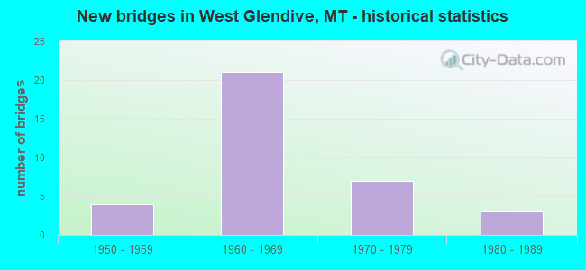
- New bridges - historical statistics
- 41950-1959
- 211960-1969
- 71970-1979
- 31980-1989


- Bridge Condition - Deck
- 8.7%Good
- 73.9%Satisfactory
- 17.4%Fair

- Bridge Condition - Superstructure
- 39.1%Good
- 52.2%Satisfactory
- 8.7%Fair

- Bridge Condition - Substructure
- 30.4%Good
- 56.5%Satisfactory
- 8.7%Fair
- 4.3%Poor

- Bridge Condition - Channel
- 15.4%Very good
- 46.2%Good
- 30.8%Satisfactory
- 7.7%Fair
Find on map >> Show street view
Structure Number: I00094206+08501, Location: 4M SW GLENIDVE (Lat: 47.040439, Lng: -104.810706), Route carried "on" structure: Interstate 94, Year Built: 1976, Status: Open, Structure Length: 1.26m (4.13ft), Average Daily Traffic: 4,294 (year 2020), Truck Traffic: 27%, Average Future Daily Traffic: 4,509 (year 2040), Design Load: HS 20, Features Intersected: SAND CREEK
Minimum Vertical Clearance: 30+ m (98+ ft), Kilometerpoint: 332.039, Lanes on structure: 4, Base Highway Network: Yes, Owner: State Highway Agency, Approaching Roadway Width: 11.6m (38.1ft), Skew: 1 degrees, Material/Design: Steel, Design/Construction: Culvert, Number Of Spans In Main Unit: 3, Length of Maximum Span: 3.3m (10.8ft)
Condition: Channel: Satisfactory, Culverts: Satisfactory, Structural Evaluation: Equal to present minimum criteria, Waterway Adequacy: Equal to present minimum criteria, Approach Roadway Alignment: Equal to present desirable criteria, Designated Inspection Frequency: Every 24 months, Inspection Date: May 2020
Find on map >> Show street view
Structure Number: I00094208+09521, Location: 1M SW GLENDIVE (Lat: 47.066925, Lng: -104.791133), Route carried "on" structure: Interstate 94, Year Built: 1976, Status: Open, Structure Length: 2.38m (7.81ft), Average Daily Traffic: 4,294 (year 2020), Truck Traffic: 27%, Average Future Daily Traffic: 4,509 (year 2040), Design Load: HS 20, Features Intersected: SEP ROAD 240
Minimum Vertical Clearance: 30+ m (98+ ft), Kilometerpoint: 335.337, Lanes on structure: 2, Lanes under structure: 2, Base Highway Network: Yes, Owner: State Highway Agency, Approaching Roadway Width: 11.8m (38.7ft), Material/Design: Concrete continuous, Design/Construction: Slab, Number Of Spans In Main Unit: 3, Length of Maximum Span: 9.1m (29.9ft), Curb or Sidewalk Widths: Left: 0.1m (0.3ft), Right: 0.1m (0.3ft), Curb-To-Curb Width: 12.6m (41.3ft), Out-to-Out Width: 13.4m (44.0ft)
Condition: Deck: Satisfactory, Superstructure: Satisfactory, Substructure: Satisfactory, Operating Rating: 36.3 metric tons, Method Used To Determine Operating Rating: Load and Resistance Factor (LRFR), Inventory Rating: 28.1 metric tons, Method Used To Determine Inventory Rating: Load and Resistance Factor (LRFR), Structural Evaluation: Equal to present minimum criteria, Deck Geometry: Better than present minimum criteria, Underclear: High priority of corrective action, Approach Roadway Alignment: Equal to present desirable criteria, Designated Inspection Frequency: Every 24 months, Inspection Date: May 2020, Deck Structure Type: Concrete Cast-file-Place, Wearing Surface/Protective System: Wearing Surface: Monolithic Concrete
Find on map >> Show street view
Structure Number: I00094208+09522, Location: 1M SW GLENDIVE (Lat: 47.067056, Lng: -104.791508), Route carried "on" structure: Interstate 94, Year Built: 1976, Status: Open, Structure Length: 2.38m (7.81ft), Average Daily Traffic: 4,294 (year 2020), Truck Traffic: 27%, Average Future Daily Traffic: 4,509 (year 2040), Design Load: HS 20, Features Intersected: SEP ROAD 240
Minimum Vertical Clearance: 30+ m (98+ ft), Kilometerpoint: 336.172, Lanes on structure: 2, Lanes under structure: 2, Base Highway Network: Yes, Owner: State Highway Agency, Approaching Roadway Width: 11.6m (38.1ft), Material/Design: Concrete continuous, Design/Construction: Slab, Number Of Spans In Main Unit: 3, Length of Maximum Span: 9.1m (29.9ft), Curb or Sidewalk Widths: Left: 0.1m (0.3ft), Right: 0.1m (0.3ft), Curb-To-Curb Width: 12.6m (41.3ft), Out-to-Out Width: 13.4m (44.0ft)
Condition: Deck: Satisfactory, Superstructure: Satisfactory, Substructure: Satisfactory, Operating Rating: 36.3 metric tons, Method Used To Determine Operating Rating: Load and Resistance Factor (LRFR), Inventory Rating: 28.1 metric tons, Method Used To Determine Inventory Rating: Load and Resistance Factor (LRFR), Structural Evaluation: Equal to present minimum criteria, Deck Geometry: Better than present minimum criteria, Underclear: Meets minimum limits, Approach Roadway Alignment: Equal to present desirable criteria, Designated Inspection Frequency: Every 24 months, Inspection Date: May 2020, Deck Structure Type: Concrete Cast-file-Place, Wearing Surface/Protective System: Wearing Surface: Monolithic Concrete
Find on map >> Show street view
Structure Number: I00094210+03711, Location: SW GLENDIVE (Lat: 47.086686, Lng: -104.778836), Route carried "on" structure: Interstate 94, Year Built: 1969, Status: Open, Structure Length: 5.73m (18.80ft), Average Daily Traffic: 4,706 (year 2020), Truck Traffic: 25%, Average Future Daily Traffic: 4,941 (year 2040), Design Load: HS 20, Features Intersected: INT P 98-W GLENDIVE
Minimum Vertical Clearance: 30+ m (98+ ft), Kilometerpoint: 337.735, Lanes on structure: 2, Lanes under structure: 2, Base Highway Network: Yes, Owner: State Highway Agency, Approaching Roadway Width: 11.6m (38.1ft), Skew: 2 degrees, Material/Design: Prestressed concrete, Design/Construction: Stringer/Multi-beam, Number Of Spans In Main Unit: 3, Length of Maximum Span: 23.5m (77.1ft), Curb or Sidewalk Widths: Left: 0.1m (0.3ft), Right: 0.1m (0.3ft), Curb-To-Curb Width: 11.6m (38.1ft), Out-to-Out Width: 12.3m (40.4ft)
Condition: Deck: Satisfactory, Superstructure: Good, Substructure: Good, Operating Rating: 49.0 metric tons, Method Used To Determine Operating Rating: Load and Resistance Factor (LRFR), Inventory Rating: 28.1 metric tons, Method Used To Determine Inventory Rating: Load and Resistance Factor (LRFR), Structural Evaluation: Better than present minimum criteria, Deck Geometry: Equal to present minimum criteria, Underclear: Somewhat better than minimum adequacy, Approach Roadway Alignment: Equal to present desirable criteria, Designated Inspection Frequency: Every 24 months, Inspection Date: May 2020, Deck Structure Type: Concrete Cast-file-Place, Wearing Surface/Protective System: Wearing Surface: Monolithic Concrete
Find on map >> Show street view
Structure Number: I00094210+03712, Location: SW GLENDIVE (Lat: 47.086678, Lng: -104.779172), Route carried "on" structure: Interstate 94, Year Built: 1969, Status: Open, Structure Length: 5.73m (18.80ft), Average Daily Traffic: 4,706 (year 2020), Truck Traffic: 25%, Average Future Daily Traffic: 4,941 (year 2040), Design Load: HS 20, Features Intersected: INT P 98-W GLENDIVE
Minimum Vertical Clearance: 30+ m (98+ ft), Kilometerpoint: 338.553, Lanes on structure: 2, Lanes under structure: 2, Base Highway Network: Yes, Owner: State Highway Agency, Approaching Roadway Width: 11.6m (38.1ft), Skew: 2 degrees, Material/Design: Prestressed concrete, Design/Construction: Stringer/Multi-beam, Number Of Spans In Main Unit: 3, Length of Maximum Span: 23.5m (77.1ft), Curb or Sidewalk Widths: Left: 0.1m (0.3ft), Right: 0.1m (0.3ft), Curb-To-Curb Width: 11.6m (38.1ft), Out-to-Out Width: 12.3m (40.4ft)
Condition: Deck: Satisfactory, Superstructure: Satisfactory, Substructure: Satisfactory, Operating Rating: 48.1 metric tons, Method Used To Determine Operating Rating: Load and Resistance Factor (LRFR), Inventory Rating: 28.1 metric tons, Method Used To Determine Inventory Rating: Load and Resistance Factor (LRFR), Structural Evaluation: Equal to present minimum criteria, Deck Geometry: Equal to present minimum criteria, Underclear: Somewhat better than minimum adequacy, Approach Roadway Alignment: Equal to present desirable criteria, Designated Inspection Frequency: Every 24 months, Inspection Date: May 2020, Deck Structure Type: Concrete Cast-file-Place, Wearing Surface/Protective System: Wearing Surface: Monolithic Concrete
Find on map >> Show street view
Structure Number: I00094211+04801, Location: W GLENDIVE (Lat: 47.101403, Lng: -104.769569), Route carried "on" structure: Interstate 94, Year Built: 1969, Status: Open, Structure Length: 24.04m (78.87ft), Average Daily Traffic: 4,706 (year 2020), Truck Traffic: 25%, Average Future Daily Traffic: 4,941 (year 2040), Design Load: HS 20, Features Intersected: INT CIRCLE-RR-7M CR
Minimum Vertical Clearance: 30+ m (98+ ft), Kilometerpoint: 339.522, Lanes on structure: 2, Lanes under structure: 2, Base Highway Network: Yes, Owner: State Highway Agency, Approaching Roadway Width: 11.6m (38.1ft), Material/Design: Prestressed concrete, Design/Construction: Stringer/Multi-beam, Number Of Spans In Main Unit: 13, Length of Maximum Span: 23.3m (76.4ft), Curb or Sidewalk Widths: Left: 0.1m (0.3ft), Right: 0.1m (0.3ft), Curb-To-Curb Width: 11.6m (38.1ft), Out-to-Out Width: 12.4m (40.7ft)
Condition: Deck: Fair, Superstructure: Good, Substructure: Satisfactory, Channel: Very good, Operating Rating: 41.7 metric tons, Method Used To Determine Operating Rating: Load and Resistance Factor (LRFR), Inventory Rating: 25.4 metric tons, Method Used To Determine Inventory Rating: Load and Resistance Factor (LRFR), Structural Evaluation: Equal to present minimum criteria, Deck Geometry: Equal to present minimum criteria, Underclear: High priority of corrective action, Waterway Adequacy: Equal to present desirable criteria, Approach Roadway Alignment: Equal to present desirable criteria, Designated Inspection Frequency: Every 24 months, Inspection Date: May 2020, Deck Structure Type: Concrete Cast-file-Place, Wearing Surface/Protective System: Wearing Surface: Monolithic Concrete
Find on map >> Show street view
Structure Number: I00094211+04802, Location: W GLENDIVE (Lat: 47.101461, Lng: -104.769872), Route carried "on" structure: Interstate 94, Year Built: 1969, Status: Open, Structure Length: 23.55m (77.26ft), Average Daily Traffic: 6,253 (year 2020), Truck Traffic: 19%, Average Future Daily Traffic: 7,222 (year 2040), Design Load: HS 20, Features Intersected: INT CIRCLE-RR-7M CR
Minimum Vertical Clearance: 30+ m (98+ ft), Kilometerpoint: 340.349, Lanes on structure: 2, Lanes under structure: 2, Base Highway Network: Yes, Owner: State Highway Agency, Approaching Roadway Width: 11.6m (38.1ft), Material/Design: Prestressed concrete, Design/Construction: Stringer/Multi-beam, Number Of Spans In Main Unit: 13, Length of Maximum Span: 23.5m (77.1ft), Curb or Sidewalk Widths: Left: 0.1m (0.3ft), Right: 0.1m (0.3ft), Curb-To-Curb Width: 11.6m (38.1ft), Out-to-Out Width: 12.4m (40.7ft)
Condition: Deck: Fair, Superstructure: Good, Substructure: Satisfactory, Channel: Satisfactory, Operating Rating: 48.1 metric tons, Method Used To Determine Operating Rating: Load and Resistance Factor (LRFR), Inventory Rating: 29.9 metric tons, Method Used To Determine Inventory Rating: Load and Resistance Factor (LRFR), Structural Evaluation: Equal to present minimum criteria, Deck Geometry: Equal to present minimum criteria, Underclear: High priority of corrective action, Waterway Adequacy: Equal to present desirable criteria, Approach Roadway Alignment: Equal to present desirable criteria, Designated Inspection Frequency: Every 24 months, Inspection Date: May 2020, Deck Structure Type: Concrete Cast-file-Place, Wearing Surface/Protective System: Wearing Surface: Monolithic Concrete
Find on map >> Show street view
Structure Number: I00094212+04211, Location: W GLENDIVE (Lat: 47.108978, Lng: -104.754053), Route carried "on" structure: Interstate 94, Year Built: 1969, Status: Open, Structure Length: 4.38m (14.37ft), Average Daily Traffic: 6,253 (year 2020), Truck Traffic: 19%, Average Future Daily Traffic: 7,222 (year 2040), Design Load: HS 20, Features Intersected: DRY CREEK
Minimum Vertical Clearance: 30+ m (98+ ft), Kilometerpoint: 341.010, Lanes on structure: 2, Base Highway Network: Yes, Owner: State Highway Agency, Approaching Roadway Width: 11.6m (38.1ft), Skew: 3 degrees, Material/Design: Prestressed concrete, Design/Construction: Stringer/Multi-beam, Number Of Spans In Main Unit: 2, Length of Maximum Span: 21.6m (70.9ft), Curb-To-Curb Width: 11.6m (38.1ft), Out-to-Out Width: 12.3m (40.4ft)
Condition: Deck: Satisfactory, Superstructure: Good, Substructure: Good, Channel: Satisfactory, Operating Rating: 49.9 metric tons, Method Used To Determine Operating Rating: Load and Resistance Factor (LRFR), Inventory Rating: 32.7 metric tons, Method Used To Determine Inventory Rating: Load and Resistance Factor (LRFR), Structural Evaluation: Better than present minimum criteria, Deck Geometry: Equal to present minimum criteria, Waterway Adequacy: Equal to present desirable criteria, Approach Roadway Alignment: Equal to present desirable criteria, Designated Inspection Frequency: Every 24 months, Inspection Date: November 2021, Deck Structure Type: Concrete Cast-file-Place, Wearing Surface/Protective System: Wearing Surface: Monolithic Concrete
Find on map >> Show street view
Structure Number: I00094212+04212, Location: W GLENDIVE (Lat: 47.109219, Lng: -104.754022), Route carried "on" structure: Interstate 94, Year Built: 1969, Status: Open, Structure Length: 4.38m (14.37ft), Average Daily Traffic: 6,253 (year 2020), Truck Traffic: 19%, Average Future Daily Traffic: 7,222 (year 2040), Design Load: HS 20, Features Intersected: DRY CREEK
Minimum Vertical Clearance: 30+ m (98+ ft), Kilometerpoint: 341.872, Lanes on structure: 2, Base Highway Network: Yes, Owner: State Highway Agency, Approaching Roadway Width: 11.6m (38.1ft), Skew: 3 degrees, Material/Design: Prestressed concrete, Design/Construction: Stringer/Multi-beam, Number Of Spans In Main Unit: 2, Length of Maximum Span: 21.6m (70.9ft), Curb-To-Curb Width: 11.6m (38.1ft), Out-to-Out Width: 12.3m (40.4ft)
Condition: Deck: Satisfactory, Superstructure: Good, Substructure: Satisfactory, Channel: Satisfactory, Operating Rating: 49.9 metric tons, Method Used To Determine Operating Rating: Load and Resistance Factor (LRFR), Inventory Rating: 29.0 metric tons, Method Used To Determine Inventory Rating: Load and Resistance Factor (LRFR), Structural Evaluation: Equal to present minimum criteria, Deck Geometry: Equal to present minimum criteria, Waterway Adequacy: Equal to present desirable criteria, Approach Roadway Alignment: Equal to present desirable criteria, Designated Inspection Frequency: Every 24 months, Inspection Date: November 2021, Deck Structure Type: Concrete Cast-file-Place, Wearing Surface/Protective System: Wearing Surface: Epoxy Overlay
Find on map >> Show street view
Structure Number: I00094213+03641, Location: NW GLENDIVE (Lat: 47.114875, Lng: -104.736094), Route carried "on" structure: Interstate 94, Year Built: 1969, Status: Open, Structure Length: 6.67m (21.88ft), Average Daily Traffic: 6,764 (year 2020), Truck Traffic: 18%, Average Future Daily Traffic: 7,812 (year 2040), Design Load: HS 20, Features Intersected: INT P 20-SIDNEY
Minimum Vertical Clearance: 30+ m (98+ ft), Kilometerpoint: 342.521, Lanes on structure: 2, Lanes under structure: 2, Base Highway Network: Yes, Owner: State Highway Agency, Approaching Roadway Width: 11.6m (38.1ft), Skew: 3 degrees, Material/Design: Prestressed concrete, Design/Construction: Stringer/Multi-beam, Number Of Spans In Main Unit: 3, Length of Maximum Span: 23.5m (77.1ft), Curb or Sidewalk Widths: Left: 0.1m (0.3ft), Right: 0.1m (0.3ft), Curb-To-Curb Width: 11.6m (38.1ft), Out-to-Out Width: 12.4m (40.7ft)
Condition: Deck: Fair, Superstructure: Good, Substructure: Satisfactory, Operating Rating: 32.7 metric tons, Method Used To Determine Operating Rating: Field evaluation and documented engineering judgment, Inventory Rating: 27.2 metric tons, Method Used To Determine Inventory Rating: Field evaluation and documented engineering judgment, Structural Evaluation: Equal to present minimum criteria, Deck Geometry: Equal to present minimum criteria, Underclear: Meets minimum limits, Approach Roadway Alignment: Equal to present desirable criteria, Designated Inspection Frequency: Every 24 months, Inspection Date: May 2020, Deck Structure Type: Concrete Cast-file-Place, Wearing Surface/Protective System: Wearing Surface: Monolithic Concrete
Find on map >> Show street view
Structure Number: I00094213+03642, Location: NW GLENDIVE (Lat: 47.115133, Lng: -104.736033), Route carried "on" structure: Interstate 94, Year Built: 1969, Status: Open, Structure Length: 6.67m (21.88ft), Average Daily Traffic: 6,764 (year 2020), Truck Traffic: 18%, Average Future Daily Traffic: 7,812 (year 2040), Design Load: HS 20, Features Intersected: INT P 20-SIDNEY
Minimum Vertical Clearance: 30+ m (98+ ft), Kilometerpoint: 343.387, Lanes on structure: 2, Lanes under structure: 2, Base Highway Network: Yes, Owner: State Highway Agency, Approaching Roadway Width: 11.6m (38.1ft), Skew: 3 degrees, Material/Design: Prestressed concrete, Design/Construction: Stringer/Multi-beam, Number Of Spans In Main Unit: 3, Length of Maximum Span: 23.5m (77.1ft), Curb or Sidewalk Widths: Left: 0.1m (0.3ft), Right: 0.1m (0.3ft), Curb-To-Curb Width: 11.6m (38.1ft), Out-to-Out Width: 12.4m (40.7ft)
Condition: Deck: Fair, Superstructure: Fair, Substructure: Satisfactory, Operating Rating: 32.7 metric tons, Method Used To Determine Operating Rating: Field evaluation and documented engineering judgment, Inventory Rating: 27.2 metric tons, Method Used To Determine Inventory Rating: Field evaluation and documented engineering judgment, Structural Evaluation: Somewhat better than minimum adequacy, Deck Geometry: Equal to present minimum criteria, Underclear: Meets minimum limits, Approach Roadway Alignment: Equal to present desirable criteria, Designated Inspection Frequency: Every 24 months, Inspection Date: May 2020, Deck Structure Type: Concrete Cast-file-Place, Wearing Surface/Protective System: Wearing Surface: Monolithic Concrete
Find on map >> Show street view
Structure Number: I00094213+06021, Location: NW GLENDIVE (Lat: 47.116475, Lng: -104.731525), Route carried "on" structure: Interstate 94, Year Built: 1969, Status: Open, Structure Length: 7.83m (25.69ft), Average Daily Traffic: 6,764 (year 2020), Truck Traffic: 18%, Average Future Daily Traffic: 7,812 (year 2040), Design Load: HS 20, Features Intersected: RR
Minimum Vertical Clearance: 30+ m (98+ ft), Kilometerpoint: 342.912, Lanes on structure: 2, Base Highway Network: Yes, Owner: State Highway Agency, Approaching Roadway Width: 11.6m (38.1ft), Skew: 3 degrees, Material/Design: Prestressed concrete, Design/Construction: Stringer/Multi-beam, Number Of Spans In Main Unit: 3, Length of Maximum Span: 28.3m (92.8ft), Curb or Sidewalk Widths: Left: 0.1m (0.3ft), Right: 0.1m (0.3ft), Curb-To-Curb Width: 11.6m (38.1ft), Out-to-Out Width: 12.3m (40.4ft)
Condition: Deck: Satisfactory, Superstructure: Good, Substructure: Fair, Operating Rating: 59.9 metric tons, Method Used To Determine Operating Rating: Load and Resistance Factor (LRFR), Inventory Rating: 37.2 metric tons, Method Used To Determine Inventory Rating: Load and Resistance Factor (LRFR), Structural Evaluation: Somewhat better than minimum adequacy, Deck Geometry: Equal to present minimum criteria, Underclear: Better than present minimum criteria, Approach Roadway Alignment: Equal to present desirable criteria, Designated Inspection Frequency: Every 24 months, Inspection Date: May 2020, Deck Structure Type: Concrete Cast-file-Place, Wearing Surface/Protective System: Wearing Surface: Monolithic Concrete
Find on map >> Show street view
Structure Number: I00094213+06022, Location: NW GLENDIVE (Lat: 47.116772, Lng: -104.731375), Route carried "on" structure: Interstate 94, Year Built: 1969, Status: Open, Structure Length: 7.77m (25.49ft), Average Daily Traffic: 6,764 (year 2020), Truck Traffic: 18%, Average Future Daily Traffic: 7,812 (year 2040), Design Load: HS 20, Features Intersected: RR
Minimum Vertical Clearance: 30+ m (98+ ft), Kilometerpoint: 343.785, Lanes on structure: 2, Base Highway Network: Yes, Owner: State Highway Agency, Approaching Roadway Width: 11.6m (38.1ft), Skew: 3 degrees, Material/Design: Prestressed concrete, Design/Construction: Stringer/Multi-beam, Number Of Spans In Main Unit: 3, Length of Maximum Span: 28.3m (92.8ft), Curb or Sidewalk Widths: Left: 0.1m (0.3ft), Right: 0.1m (0.3ft), Curb-To-Curb Width: 11.6m (38.1ft), Out-to-Out Width: 12.3m (40.4ft)
Condition: Deck: Satisfactory, Superstructure: Good, Substructure: Satisfactory, Operating Rating: 59.9 metric tons, Method Used To Determine Operating Rating: Load and Resistance Factor (LRFR), Inventory Rating: 37.2 metric tons, Method Used To Determine Inventory Rating: Load and Resistance Factor (LRFR), Structural Evaluation: Equal to present minimum criteria, Deck Geometry: Equal to present minimum criteria, Underclear: Better than present minimum criteria, Approach Roadway Alignment: Equal to present desirable criteria, Designated Inspection Frequency: Every 24 months, Inspection Date: May 2020, Deck Structure Type: Concrete Cast-file-Place, Wearing Surface/Protective System: Wearing Surface: Monolithic Concrete
Find on map >> Show street view
Structure Number: L11002000+03001, Location: 3M W GLENDIVE (Lat: 47.095500, Lng: -104.817756), Route carried "on" structure: County highway 11002, Year Built: 1983, Status: Open, Structure Length: 2.27m (7.45ft), Average Daily Traffic: 47 (year 2020), Truck Traffic: 3%, Average Future Daily Traffic: 49 (year 2040), Design Load: HS 20, Features Intersected: SEVEN MILE CREEK 025, Facility Carried by Structure: PLEASANT VIEW RD
Minimum Vertical Clearance: 30+ m (98+ ft), Kilometerpoint: 0.425, Lanes on structure: 2, Owner: County Highway Agency, Approaching Roadway Width: 8.5m (27.9ft), Material/Design: Steel continuous, Design/Construction: Stringer/Multi-beam, Number Of Spans In Main Unit: 4, Length of Maximum Span: 6.1m (20.0ft), Curb or Sidewalk Widths: Left: 0.1m (0.3ft), Right: 0.1m (0.3ft), Curb-To-Curb Width: 7.9m (25.9ft), Out-to-Out Width: 8.3m (27.2ft)
Condition: Deck: Satisfactory, Superstructure: Fair, Substructure: Poor, Channel: Good, Operating Rating: 59.0 metric tons, Method Used To Determine Operating Rating: Load Factor (LF), Inventory Rating: 35.4 metric tons, Method Used To Determine Inventory Rating: Load Factor (LF), Structural Evaluation: Meets minimum limits, Deck Geometry: Equal to present minimum criteria, Waterway Adequacy: Equal to present desirable criteria, Approach Roadway Alignment: Equal to present minimum criteria, Designated Inspection Frequency: Every 24 months, Inspection Date: March 2021, Deck Structure Type: Concrete Cast-file-Place, Wearing Surface/Protective System: Wearing Surface: Gravel
Find on map >> Show street view
Structure Number: L11020000+04001, Location: 1M SW GLENDIVE (Lat: 47.093331, Lng: -104.775569), Route carried "on" structure: ServiceCounty highway 11020, Year Built: 1969, Status: Open, Structure Length: 8.57m (28.12ft), Average Daily Traffic: 100 (year 2022), Truck Traffic: 3%, Average Future Daily Traffic: 100 (year 2037), Design Load: HS 15, Features Intersected: SEP I 94-7 MILE DR 094, Facility Carried by Structure: SEVEN MILE DR
Minimum Vertical Clearance: 30+ m (98+ ft), Kilometerpoint: 0.503, Lanes on structure: 2, Lanes under structure: 4, Owner: State Highway Agency, Approaching Roadway Width: 7.4m (24.3ft), Skew: 2 degrees, Material/Design: Prestressed concrete, Design/Construction: Stringer/Multi-beam, Number Of Spans In Main Unit: 4, Length of Maximum Span: 23.5m (77.1ft), Curb or Sidewalk Widths: Left: 0.1m (0.3ft), Right: 0.1m (0.3ft), Curb-To-Curb Width: 9.6m (31.5ft), Out-to-Out Width: 10.4m (34.1ft)
Condition: Deck: Satisfactory, Superstructure: Satisfactory, Substructure: Satisfactory, Operating Rating: 40.8 metric tons, Method Used To Determine Operating Rating: Load and Resistance Factor (LRFR), Inventory Rating: 22.7 metric tons, Method Used To Determine Inventory Rating: Load and Resistance Factor (LRFR), Structural Evaluation: Equal to present minimum criteria, Deck Geometry: Better than present minimum criteria, Underclear: Equal to present minimum criteria, Approach Roadway Alignment: Equal to present desirable criteria, Designated Inspection Frequency: Every 24 months, Inspection Date: November 2021, Deck Structure Type: Concrete Cast-file-Place, Wearing Surface/Protective System: Wearing Surface: Monolithic Concrete
Find on map >> Show street view
Structure Number: L11109004+09001, Location: 8M SW GLENDIVE (Lat: 47.034317, Lng: -104.794358), Route carried "on" structure: County highway 11109, Year Built: 1988, Status: Open, Structure Length: 1.17m (3.84ft), Average Daily Traffic: 691 (year 2020), Truck Traffic: 3%, Average Future Daily Traffic: 726 (year 2040), Features Intersected: SAND CREEK 038, Facility Carried by Structure: ROAD 261
Minimum Vertical Clearance: 30+ m (98+ ft), Kilometerpoint: 8.049, Lanes on structure: 2, Owner: County Highway Agency, Approaching Roadway Width: 8.5m (27.9ft), Material/Design: Steel continuous, Design/Construction: Stringer/Multi-beam, Number Of Spans In Main Unit: 2, Length of Maximum Span: 5.5m (18.0ft), Curb or Sidewalk Widths: Left: 0.2m (0.7ft), Right: 0.2m (0.7ft), Curb-To-Curb Width: 9.2m (30.2ft), Out-to-Out Width: 9.8m (32.2ft)
Condition: Deck: Satisfactory, Superstructure: Satisfactory, Substructure: Fair, Channel: Fair, Operating Rating: 88.9 metric tons, Method Used To Determine Operating Rating: Load Factor (LF), Inventory Rating: 53.5 metric tons, Method Used To Determine Inventory Rating: Load Factor (LF), Structural Evaluation: Somewhat better than minimum adequacy, Deck Geometry: Equal to present minimum criteria, Waterway Adequacy: Equal to present desirable criteria, Approach Roadway Alignment: Meets minimum limits, Designated Inspection Frequency: Every 24 months, Underwater Inspection Frequency: Every 48 months, Inspection Date: November 2021, Underwater Inspection Date: November 2019, Deck Structure Type: Concrete Cast-file-Place, Wearing Surface/Protective System: Wearing Surface: Gravel
Find on map >> Show street view
Structure Number: L11125000+03001, Location: 8M S GLENDIVE (Lat: 47.035294, Lng: -104.801947), Route carried "on" structure: County highway 11125, Year Built: 1983, Status: Open, Structure Length: 1.13m (3.71ft), Average Daily Traffic: 100 (year 2022), Truck Traffic: 3%, Average Future Daily Traffic: 100 (year 2037), Features Intersected: IRRIGATION CANAL 049, Facility Carried by Structure: PLEASANT VIEW RD
Minimum Vertical Clearance: 30+ m (98+ ft), Kilometerpoint: 0.779, Lanes on structure: 2, Owner: County Highway Agency, Approaching Roadway Width: 7.0m (23.0ft), Skew: 3 degrees, Material/Design: Steel continuous, Design/Construction: Stringer/Multi-beam, Number Of Spans In Main Unit: 2, Length of Maximum Span: 5.5m (18.0ft), Curb or Sidewalk Widths: Left: 0.2m (0.7ft), Right: 0.2m (0.7ft), Curb-To-Curb Width: 6.2m (20.3ft), Out-to-Out Width: 6.6m (21.7ft)
Condition: Deck: Good, Superstructure: Satisfactory, Substructure: Good, Channel: Very good, Structural Evaluation: Equal to present minimum criteria, Deck Geometry: Somewhat better than minimum adequacy, Waterway Adequacy: Equal to present desirable criteria, Approach Roadway Alignment: Equal to present minimum criteria, Designated Inspection Frequency: Every 24 months, Inspection Date: November 2021, Deck Structure Type: Concrete Cast-file-Place, Wearing Surface/Protective System: Wearing Surface: Integral Concrete
Find on map >> Show street view
Structure Number: L11125000+07001, Location: 7M SW GLENDIVE (Lat: 47.035300, Lng: -104.814475), Route carried "on" structure: ServiceCounty highway 11125, Year Built: 1976, Status: Open, Structure Length: 9.17m (30.09ft), Average Daily Traffic: 100 (year 2022), Truck Traffic: 3%, Average Future Daily Traffic: 100 (year 2037), Design Load: HS 20, Features Intersected: INT PLSNT VW RD-I 94 093, Facility Carried by Structure: PLEASANT VIEW RD
Minimum Vertical Clearance: 30+ m (98+ ft), Kilometerpoint: 1.731, Lanes on structure: 2, Lanes under structure: 4, Owner: State Highway Agency, Approaching Roadway Width: 9.8m (32.2ft), Skew: 2 degrees, Material/Design: Prestressed concrete, Design/Construction: Stringer/Multi-beam, Number Of Spans In Main Unit: 4, Length of Maximum Span: 32.6m (107.0ft), Curb or Sidewalk Widths: Left: 0.1m (0.3ft), Right: 0.1m (0.3ft), Curb-To-Curb Width: 9.6m (31.5ft), Out-to-Out Width: 10.5m (34.4ft)
Condition: Deck: Satisfactory, Superstructure: Satisfactory, Substructure: Satisfactory, Operating Rating: 53.5 metric tons, Method Used To Determine Operating Rating: Load and Resistance Factor (LRFR), Inventory Rating: 35.4 metric tons, Method Used To Determine Inventory Rating: Load and Resistance Factor (LRFR), Structural Evaluation: Equal to present minimum criteria, Deck Geometry: Better than present minimum criteria, Underclear: Better than present minimum criteria, Approach Roadway Alignment: Equal to present desirable criteria, Designated Inspection Frequency: Every 24 months, Inspection Date: January 2021, Deck Structure Type: Concrete Cast-file-Place, Wearing Surface/Protective System: Wearing Surface: Monolithic Concrete
Find on map >> Show street view
Structure Number: L11330000+05001, Location: GLENDIVE-JEFFRSN SCHL RD (Lat: 47.111386, Lng: -104.746953), Route carried "on" structure: ServiceCity street 5001, Year Built: 1969, Status: Open, Structure Length: 8.87m (29.10ft), Average Daily Traffic: 512 (year 2020), Average Future Daily Traffic: 538 (year 2040), Design Load: HS 15, Features Intersected: SEP I 94 002, Facility Carried by Structure: JEFFERSON SCHL RD
Minimum Vertical Clearance: 30+ m (98+ ft), Kilometerpoint: 0.996, Lanes on structure: 2, Lanes under structure: 4, Owner: State Highway Agency, Approaching Roadway Width: 9.1m (29.9ft), Skew: 2 degrees, Material/Design: Prestressed concrete, Design/Construction: Stringer/Multi-beam, Number Of Spans In Main Unit: 4, Length of Maximum Span: 23.5m (77.1ft), Curb or Sidewalk Widths: Left: 1.5m (4.9ft), Right: 0.0m, Curb-To-Curb Width: 10.4m (34.1ft), Out-to-Out Width: 12.6m (41.3ft)
Condition: Deck: Satisfactory, Superstructure: Satisfactory, Substructure: Satisfactory, Operating Rating: 38.1 metric tons, Method Used To Determine Operating Rating: Load and Resistance Factor (LRFR), Inventory Rating: 17.2 metric tons, Method Used To Determine Inventory Rating: Load and Resistance Factor (LRFR), Structural Evaluation: Meets minimum limits, Deck Geometry: Equal to present minimum criteria, Underclear: Equal to present minimum criteria, Approach Roadway Alignment: Equal to present minimum criteria, Designated Inspection Frequency: Every 24 months, Inspection Date: January 2021, Deck Structure Type: Concrete Cast-file-Place, Wearing Surface/Protective System: Wearing Surface: Monolithic Concrete
Find on map >> Show street view
Structure Number: P00057326+00931, Location: WEST GLENDIVE (Lat: 47.103167, Lng: -104.746278), Route carried "on" structure: State highway 200, Year Built: 1959, Status: Open, Structure Length: 3.66m (12.01ft), Average Daily Traffic: 5,178 (year 2020), Truck Traffic: 5%, Average Future Daily Traffic: 5,437 (year 2040), Design Load: HS 20, Features Intersected: DRY CREEK
Minimum Vertical Clearance: 30+ m (98+ ft), Kilometerpoint: 522.154, Lanes on structure: 2, Base Highway Network: Yes, Owner: State Highway Agency, Approaching Roadway Width: 11.0m (36.1ft), Material/Design: Concrete continuous, Design/Construction: Tee Beam, Number Of Spans In Main Unit: 4, Length of Maximum Span: 13.7m (44.9ft), Curb-To-Curb Width: 8.5m (27.9ft), Out-to-Out Width: 9.7m (31.8ft)
Condition: Deck: Satisfactory, Superstructure: Satisfactory, Substructure: Satisfactory, Channel: Good, Operating Rating: 31.8 metric tons, Method Used To Determine Operating Rating: Load and Resistance Factor (LRFR), Inventory Rating: 24.5 metric tons, Method Used To Determine Inventory Rating: Load and Resistance Factor (LRFR), Structural Evaluation: Equal to present minimum criteria, Deck Geometry: High priority of corrective action, Waterway Adequacy: Equal to present desirable criteria, Approach Roadway Alignment: Equal to present desirable criteria, Designated Inspection Frequency: Every 24 months, Inspection Date: January 2021, Deck Structure Type: Concrete Cast-file-Place, Wearing Surface/Protective System: Wearing Surface: Monolithic Concrete
Find on map >> Show street view
Structure Number: P00057326+00932, Location: WEST GLENDIVE (Lat: 47.103250, Lng: -104.746389), Route carried "on" structure: Business State highway 200, Year Built: 1959, Status: Open, Structure Length: 3.66m (12.01ft), Average Daily Traffic: 5,178 (year 2020), Truck Traffic: 5%, Average Future Daily Traffic: 5,437 (year 2040), Design Load: HS 20, Features Intersected: DRY CREEK
Minimum Vertical Clearance: 5.00m (16.40ft), Kilometerpoint: 522.153, Lanes on structure: 2, Base Highway Network: Yes, Owner: State Highway Agency, Approaching Roadway Width: 11.0m (36.1ft), Material/Design: Concrete continuous, Design/Construction: Tee Beam, Number Of Spans In Main Unit: 4, Length of Maximum Span: 13.7m (44.9ft), Curb-To-Curb Width: 8.5m (27.9ft), Out-to-Out Width: 9.7m (31.8ft)
Condition: Deck: Satisfactory, Superstructure: Satisfactory, Substructure: Good, Channel: Good, Operating Rating: 31.8 metric tons, Method Used To Determine Operating Rating: Load and Resistance Factor (LRFR), Inventory Rating: 24.5 metric tons, Method Used To Determine Inventory Rating: Load and Resistance Factor (LRFR), Structural Evaluation: Equal to present minimum criteria, Deck Geometry: High priority of corrective action, Waterway Adequacy: Equal to present desirable criteria, Approach Roadway Alignment: Equal to present desirable criteria, Designated Inspection Frequency: Every 24 months, Inspection Date: January 2021, Deck Structure Type: Concrete Cast-file-Place, Wearing Surface/Protective System: Wearing Surface: Monolithic Concrete
Find on map >> Show street view
Structure Number: P00098000+09741, Location: 1M SW GLENDIVE (Lat: 47.095469, Lng: -104.763119), Route carried "on" structure: City street 98, Year Built: 1959, Status: Open, Structure Length: 3.66m (12.01ft), Average Daily Traffic: 2,264 (year 2020), Truck Traffic: 7%, Average Future Daily Traffic: 2,377 (year 2040), Design Load: HS 20, Features Intersected: UPPER SEVEN MILE CREEK, Facility Carried by Structure: US 94
Minimum Vertical Clearance: 30+ m (98+ ft), Kilometerpoint: 1.612, Lanes on structure: 2, Base Highway Network: Yes, Owner: State Highway Agency, Approaching Roadway Width: 11.6m (38.1ft), Material/Design: Concrete continuous, Design/Construction: Tee Beam, Number Of Spans In Main Unit: 4, Length of Maximum Span: 13.7m (44.9ft), Curb-To-Curb Width: 8.5m (27.9ft), Out-to-Out Width: 9.7m (31.8ft)
Condition: Deck: Satisfactory, Superstructure: Satisfactory, Substructure: Good, Channel: Good, Operating Rating: 32.7 metric tons, Method Used To Determine Operating Rating: Load and Resistance Factor (LRFR), Inventory Rating: 25.4 metric tons, Method Used To Determine Inventory Rating: Load and Resistance Factor (LRFR), Structural Evaluation: Equal to present minimum criteria, Deck Geometry: Meets minimum limits, Waterway Adequacy: Equal to present minimum criteria, Approach Roadway Alignment: Equal to present minimum criteria, Designated Inspection Frequency: Every 24 months, Inspection Date: January 2021, Deck Structure Type: Concrete Cast-file-Place, Wearing Surface/Protective System: Wearing Surface: Monolithic Concrete
Find on map >> Show street view
Structure Number: P00098000+09742, Location: 1M SW GLENDIVE (Lat: 47.095561, Lng: -104.763225), Route carried "on" structure: Business City street 98, Year Built: 1959, Status: Open, Structure Length: 3.66m (12.01ft), Average Daily Traffic: 2,264 (year 2020), Truck Traffic: 7%, Average Future Daily Traffic: 2,377 (year 2040), Design Load: HS 20, Features Intersected: UPPER SEVEN MILE CREEK, Facility Carried by Structure: US 94
Minimum Vertical Clearance: 30+ m (98+ ft), Kilometerpoint: 1.610, Lanes on structure: 2, Base Highway Network: Yes, Owner: State Highway Agency, Approaching Roadway Width: 11.6m (38.1ft), Material/Design: Concrete continuous, Design/Construction: Tee Beam, Number Of Spans In Main Unit: 4, Length of Maximum Span: 13.7m (44.9ft), Curb-To-Curb Width: 8.5m (27.9ft), Out-to-Out Width: 9.7m (31.8ft)
Condition: Deck: Satisfactory, Superstructure: Satisfactory, Substructure: Good, Channel: Good, Operating Rating: 33.6 metric tons, Method Used To Determine Operating Rating: Load and Resistance Factor (LRFR), Inventory Rating: 25.4 metric tons, Method Used To Determine Inventory Rating: Load and Resistance Factor (LRFR), Structural Evaluation: Equal to present minimum criteria, Deck Geometry: High priority of corrective action, Waterway Adequacy: Equal to present minimum criteria, Approach Roadway Alignment: Equal to present minimum criteria, Designated Inspection Frequency: Every 24 months, Inspection Date: January 2021, Deck Structure Type: Concrete Cast-file-Place, Wearing Surface/Protective System: Wearing Surface: Monolithic Concrete
Find on map >> Show street view
Structure Number: S00335005+08631, Location: 5M S GLENDIVE (Lat: 47.024694, Lng: -104.741281), Route carried "on" structure: State highway 335, Year Built: 1966, Status: Open, Structure Length: 3.09m (10.14ft), Average Daily Traffic: 88 (year 2020), Truck Traffic: 7%, Average Future Daily Traffic: 92 (year 2040), Design Load: HS 20, Features Intersected: SAND CREEK, Facility Carried by Structure: MARSH RD
Minimum Vertical Clearance: 30+ m (98+ ft), Kilometerpoint: 9.804, Lanes on structure: 2, Owner: State Highway Agency, Approaching Roadway Width: 9.1m (29.9ft), Material/Design: Prestressed concrete, Design/Construction: Stringer/Multi-beam, Number Of Spans In Main Unit: 2, Length of Maximum Span: 15.2m (49.9ft), Curb-To-Curb Width: 9.1m (29.9ft), Out-to-Out Width: 10.8m (35.4ft)
Condition: Deck: Good, Superstructure: Good, Substructure: Good, Channel: Good, Operating Rating: 42.6 metric tons, Method Used To Determine Operating Rating: Load and Resistance Factor (LRFR), Inventory Rating: 32.7 metric tons, Method Used To Determine Inventory Rating: Load and Resistance Factor (LRFR), Structural Evaluation: Better than present minimum criteria, Deck Geometry: Better than present minimum criteria, Waterway Adequacy: Equal to present desirable criteria, Approach Roadway Alignment: Equal to present desirable criteria, Designated Inspection Frequency: Every 48 months, Inspection Date: December 2020, Deck Structure Type: Concrete Cast-file-Place
Find on map >> Show street view
Structure Number: I00094208+09521, Location: 1M SW GLENDIVE (Lat: 47.066925, Lng: -104.791133), Route carried "under" structure: ServiceCounty highway 11036, Year Built: 1976, Structure Length: 0. m, Average Daily Traffic: 100 (year 2022), Truck Traffic: 3%, Features Intersected: SEP ROAD 240, Facility Carried by Structure: I 94
Minimum Vertical Clearance: 4.42m (14.50ft), Kilometerpoint: 1.690, Lanes on structure: 2, Lanes under structure: 2, Material/Design: Concrete continuous, Design/Construction: Slab, Length of Maximum Span: 9.1m (29.9ft)
Find on map >> Show street view
Structure Number: I00094208+09522, Location: 1M SW GLENDIVE (Lat: 47.067056, Lng: -104.791508), Route carried "under" structure: ServiceCounty highway 11036, Year Built: 1976, Structure Length: 0. m, Average Daily Traffic: 100 (year 2022), Truck Traffic: 3%, Features Intersected: SEP ROAD 240, Facility Carried by Structure: I 94
Minimum Vertical Clearance: 4.58m (15.03ft), Kilometerpoint: 1.722, Lanes on structure: 2, Lanes under structure: 2, Material/Design: Concrete continuous, Design/Construction: Slab, Length of Maximum Span: 9.1m (29.9ft)
Find on map >> Show street view
Structure Number: I00094210+03711, Location: SW GLENDIVE (Lat: 47.086686, Lng: -104.778836), Route carried "under" structure: Business US 98, Year Built: 1969, Structure Length: 0. m, Average Daily Traffic: 1,085 (year 2020), Truck Traffic: 15%, Features Intersected: INT P 98-W GLENDIVE, Facility Carried by Structure: I 94
Minimum Vertical Clearance: 5.58m (18.31ft), Kilometerpoint: 0.000, Lanes on structure: 2, Lanes under structure: 2, Material/Design: Prestressed concrete, Design/Construction: Stringer/Multi-beam, Length of Maximum Span: 23.5m (77.1ft)
Find on map >> Show street view
Structure Number: I00094210+03712, Location: SW GLENDIVE (Lat: 47.086678, Lng: -104.779172), Route carried "under" structure: Business US 98, Year Built: 1969, Structure Length: 0. m, Average Daily Traffic: 1,085 (year 2020), Truck Traffic: 15%, Features Intersected: INT P 98-W GLENDIVE, Facility Carried by Structure: I 94
Minimum Vertical Clearance: 4.98m (16.34ft), Kilometerpoint: 0.000, Lanes on structure: 2, Lanes under structure: 2, Material/Design: Prestressed concrete, Design/Construction: Stringer/Multi-beam, Length of Maximum Span: 23.5m (77.1ft)
Find on map >> Show street view
Structure Number: I00094211+04801, Location: W GLENDIVE (Lat: 47.101403, Lng: -104.769569), Route carried "under" structure: Spur State highway 57, Year Built: 1969, Structure Length: 0. m, Average Daily Traffic: 2,108 (year 2020), Truck Traffic: 4%, Features Intersected: INT CIRCLE-RR-7M CR, Facility Carried by Structure: I 94
Minimum Vertical Clearance: 5.06m (16.60ft), Kilometerpoint: 520.358, Lanes on structure: 2, Lanes under structure: 2, Material/Design: Prestressed concrete, Design/Construction: Stringer/Multi-beam, Length of Maximum Span: 23.3m (76.4ft)
Find on map >> Show street view
Structure Number: I00094211+04802, Location: W GLENDIVE (Lat: 47.101461, Lng: -104.769872), Route carried "under" structure: Spur State highway 57, Year Built: 1969, Structure Length: 0. m, Average Daily Traffic: 2,108 (year 2020), Truck Traffic: 4%, Features Intersected: INT CIRCLE-RR-7M CR, Facility Carried by Structure: I 94
Minimum Vertical Clearance: 4.93m (16.17ft), Kilometerpoint: 520.336, Lanes on structure: 2, Lanes under structure: 2, Material/Design: Prestressed concrete, Design/Construction: Stringer/Multi-beam, Length of Maximum Span: 23.5m (77.1ft)
Find on map >> Show street view
Structure Number: I00094213+03641, Location: NW GLENDIVE (Lat: 47.114875, Lng: -104.736094), Route carried "under" structure: State highway 20, Year Built: 1969, Structure Length: 0. m, Average Daily Traffic: 7,581 (year 2020), Truck Traffic: 4%, Features Intersected: INT P 20-SIDNEY, Facility Carried by Structure: I 94
Minimum Vertical Clearance: 5.54m (18.18ft), Kilometerpoint: 0.959, Lanes on structure: 2, Lanes under structure: 2, Material/Design: Prestressed concrete, Design/Construction: Stringer/Multi-beam, Length of Maximum Span: 23.5m (77.1ft)
Find on map >> Show street view
Structure Number: I00094213+03642, Location: NW GLENDIVE (Lat: 47.115133, Lng: -104.736033), Route carried "under" structure: State highway 20, Year Built: 1969, Structure Length: 0. m, Average Daily Traffic: 7,581 (year 2020), Truck Traffic: 4%, Features Intersected: INT P 20-SIDNEY, Facility Carried by Structure: I 94
Minimum Vertical Clearance: 4.90m (16.08ft), Kilometerpoint: 0.989, Lanes on structure: 2, Lanes under structure: 2, Material/Design: Prestressed concrete, Design/Construction: Stringer/Multi-beam, Length of Maximum Span: 23.5m (77.1ft)
Find on map >> Show street view
Structure Number: L11020000+04001, Location: 1M SW GLENDIVE (Lat: 47.093331, Lng: -104.775569), Route carried "under" structure: Interstate 94, Year Built: 1969, Structure Length: 0. m, Average Daily Traffic: 4,706 (year 2020), Truck Traffic: 25%, Features Intersected: SEP I 94-7 MILE DR 094, Facility Carried by Structure: SEVEN MILE DR
Minimum Vertical Clearance: 5.11m (16.77ft), Kilometerpoint: 338.513, Lanes on structure: 2, Lanes under structure: 4, Material/Design: Prestressed concrete, Design/Construction: Stringer/Multi-beam, Length of Maximum Span: 23.5m (77.1ft)
Find on map >> Show street view
Structure Number: L11125000+07001, Location: 7M SW GLENDIVE (Lat: 47.035300, Lng: -104.814475), Route carried "under" structure: Interstate 94, Year Built: 1976, Structure Length: 0. m, Average Daily Traffic: 4,294 (year 2020), Truck Traffic: 27%, Features Intersected: INT PLSNT VW RD-I 94 093, Facility Carried by Structure: PLEASANT VIEW RD
Minimum Vertical Clearance: 5.36m (17.59ft), Kilometerpoint: 331.400, Lanes on structure: 2, Lanes under structure: 4, Material/Design: Prestressed concrete, Design/Construction: Stringer/Multi-beam, Length of Maximum Span: 32.6m (107.0ft)
Find on map >> Show street view
Structure Number: L11330000+05001, Location: GLENDIVE-JEFFRSN SCHL RD (Lat: 47.111386, Lng: -104.746953), Route carried "under" structure: Interstate 94, Year Built: 1969, Structure Length: 0. m, Average Daily Traffic: 6,253 (year 2020), Truck Traffic: 19%, Features Intersected: SEP I 94 002, Facility Carried by Structure: JEFFERSON SCHL RD
Minimum Vertical Clearance: 5.26m (17.26ft), Kilometerpoint: 341.609, Lanes on structure: 2, Lanes under structure: 4, Material/Design: Prestressed concrete, Design/Construction: Stringer/Multi-beam, Length of Maximum Span: 23.5m (77.1ft)