Bridge Statistics for Westlake, Louisiana (LA)
Condition, Traffic, Stress, Structural Evaluation, Project Costs
- National Bridge Inventory (NBI) Statistics
- 10Number of bridges
- 52ft / 15.8mTotal length
- 98,495Total average daily traffic
- 8,738Total average daily truck traffic
- National Bridge Inventory (NBI) Registered Bridges for Westlake
- No street view available for this location
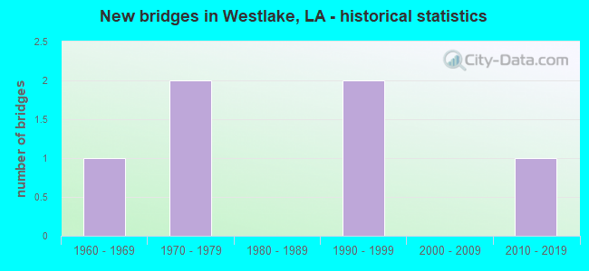
- New bridges - historical statistics
- 11960-1969
- 21970-1979
- 21990-1999
- 12010-2019


- Bridge Condition - Deck
- 50.0%Good
- 25.0%Satisfactory
- 25.0%Fair

- Bridge Condition - Superstructure
- 75.0%Good
- 25.0%Fair

- Bridge Condition - Substructure
- 75.0%Good
- 25.0%Satisfactory

- Bridge Condition - Channel
- 16.7%Very good
- 16.7%Good
- 33.3%Satisfactory
- 16.7%Fair
- 16.7%Poor

- Bridge Condition - Culverts
- 50.0%Good
- 50.0%Satisfactory
Find on map >> Show street view
Structure Number: 71000000070029, Location: 0.8 MI. NORTH OF LA 379 (Lat: 30.251239, Lng: -93.246831), Route carried "on" structure: County highway , Year Built: 2013, Status: Open, Structure Length: 4.27m (14.01ft), Average Daily Traffic: 4,463 (year 2019), Average Future Daily Traffic: 4,909 (year 2039), Design Load: HL 93, Features Intersected: MARINO BAYOU, Facility Carried by Structure: MILLER AVE
Minimum Vertical Clearance: 30+ m (98+ ft), Kilometerpoint: 0.000, Lanes on structure: 2, Owner: County Highway Agency, Approaching Roadway Width: 7.3m (24.0ft), Skew: 30 degrees, Material/Design: Concrete, Design/Construction: Slab, Number Of Spans In Main Unit: 7, Length of Maximum Span: 6.1m (20.0ft), Curb-To-Curb Width: 9.5m (31.2ft), Out-to-Out Width: 10.5m (34.4ft)
Condition: Deck: Good, Superstructure: Good, Substructure: Good, Channel: Very good, Operating Rating: 32.4 metric tons, Method Used To Determine Operating Rating: Load and Resistance Factor Rating (LRFR) rating reported by rating factor(RF) method using HL-93 loadings, Inventory Rating: 24.9 metric tons, Method Used To Determine Inventory Rating: Load and Resistance Factor Rating (LRFR) rating reported by rating factor(RF) method using HL-93 loadings, Structural Evaluation: Equal to present minimum criteria, Deck Geometry: Meets minimum limits, Waterway Adequacy: Equal to present desirable criteria, Approach Roadway Alignment: Better than present minimum criteria, Designated Inspection Frequency: Every 24 months, Underwater Inspection Frequency: Every 60 months, Inspection Date: December 2021, Underwater Inspection Date: December 2018, Deck Structure Type: Concrete Cast-file-Place, Wearing Surface/Protective System: Wearing Surface: Monolithic Concrete
Find on map >> Show street view
Structure Number: 71008101200301, Location: .3 MI NORTH OF LA 379 (Lat: 30.240961, Lng: -93.257700), Route carried "on" structure: State highway 378, Year Built: 1975, Status: Open, Structure Length: 2.01m (6.59ft), Average Daily Traffic: 25,700 (year 2016), Truck Traffic: 17%, Average Future Daily Traffic: 12,780 (year 2036), Design Load: HS 20, Features Intersected: BAYOU
Minimum Vertical Clearance: 30+ m (98+ ft), Kilometerpoint: 0.499, Lanes on structure: 4, Base Highway Network: Yes (Inventory Route: 810-12-1, Subroute: 10), Owner: State Highway Agency, Approaching Roadway Width: 21.3m (69.9ft), Skew: 27 degrees, Material/Design: Prestressed concrete, Design/Construction: Stringer/Multi-beam, Number Of Spans In Main Unit: 1, Length of Maximum Span: 20.1m (65.9ft), Curb-To-Curb Width: 21.0m (68.9ft), Out-to-Out Width: 22.0m (72.2ft)
Condition: Deck: Satisfactory, Superstructure: Good, Substructure: Good, Channel: Fair, Operating Rating: 68.9 metric tons, Method Used To Determine Operating Rating: Load Factor (LF), Inventory Rating: 32.7 metric tons, Method Used To Determine Inventory Rating: Load Factor (LF), Structural Evaluation: Better than present minimum criteria, Deck Geometry: Superior to present desirable criteria, Waterway Adequacy: Better than present minimum criteria, Approach Roadway Alignment: Equal to present minimum criteria, Designated Inspection Frequency: Every 24 months, Inspection Date: December 2021, Deck Structure Type: Concrete Cast-file-Place
Find on map >> Show street view
Structure Number: 71008101201371, Location: 1.37 MI NORTH OF LA 379 (Lat: 30.262000, Lng: -93.258200), Route carried "on" structure: State highway 378, Year Built: 1992, Status: Open, Structure Length: 0.94m (3.08ft), Average Daily Traffic: 25,700 (year 2016), Truck Traffic: 17%, Average Future Daily Traffic: 12,780 (year 2036), Design Load: HS 20, Features Intersected: BAYOU MARINA
Minimum Vertical Clearance: 30+ m (98+ ft), Kilometerpoint: 2.834, Lanes on structure: 5, Base Highway Network: Yes (Inventory Route: 810-12-1, Subroute: 10), Owner: State Highway Agency, Approaching Roadway Width: 18.9m (62.0ft), Material/Design: Concrete, Design/Construction: Culvert, Number Of Spans In Main Unit: 3, Length of Maximum Span: 3.0m (9.8ft), Curb or Sidewalk Widths: Left: 1.8m (5.9ft), Right: 1.8m (5.9ft), Curb-To-Curb Width: 18.9m (62.0ft), Out-to-Out Width: 23.8m (78.1ft)
Condition: Channel: Satisfactory, Culverts: Good, Operating Rating: 42.1 metric tons, Method Used To Determine Operating Rating: Load and Resistance Factor Rating (LRFR) rating reported by rating factor(RF) method using HL-93 loadings, Inventory Rating: 32.4 metric tons, Method Used To Determine Inventory Rating: Load and Resistance Factor Rating (LRFR) rating reported by rating factor(RF) method using HL-93 loadings, Structural Evaluation: Better than present minimum criteria, Deck Geometry: Meets minimum limits, Waterway Adequacy: Equal to present desirable criteria, Approach Roadway Alignment: Equal to present desirable criteria, Designated Inspection Frequency: Every 24 months, Inspection Date: November 2020, Deck Structure Type: Concrete Cast-file-Place
Find on map >> Show street view
Structure Number: 71030147931671, Location: 5.61 MI NE OF INT. 545 (Lat: 30.245369, Lng: -93.278950), Route carried "on" structure: County highway , Year Built: 1993, Status: Open, Structure Length: 1.04m (3.41ft), Average Daily Traffic: 8,204 (year 2021), Average Future Daily Traffic: 9,025 (year 2041), Design Load: HS 20, Features Intersected: GULLY, Facility Carried by Structure: OLD SPANISH TRAIL
Minimum Vertical Clearance: 30+ m (98+ ft), Kilometerpoint: 0.000, Lanes on structure: 2, Base Highway Network: Yes, Owner: County Highway Agency, Approaching Roadway Width: 11.0m (36.1ft), Material/Design: Steel, Design/Construction: Culvert, Number Of Spans In Main Unit: 3, Length of Maximum Span: 3.0m (9.8ft)
Condition: Channel: Poor, Culverts: Satisfactory, Operating Rating: 97.2 metric tons, Method Used To Determine Operating Rating: Load and Resistance Factor Rating (LRFR) rating reported by rating factor(RF) method using HL-93 loadings, Inventory Rating: 74.5 metric tons, Method Used To Determine Inventory Rating: Load and Resistance Factor Rating (LRFR) rating reported by rating factor(RF) method using HL-93 loadings, Structural Evaluation: Equal to present minimum criteria, Waterway Adequacy: Equal to present desirable criteria, Approach Roadway Alignment: Equal to present desirable criteria, Designated Inspection Frequency: Every 24 months, Inspection Date: December 2021
Find on map >> Show street view
Structure Number: 71030172931871, Location: 2.5 MI EAST OF LA 27 (Lat: 30.288650, Lng: -93.317400), Route carried "on" structure: County highway , Year Built: 1973, Status: Open, Structure Length: 1.16m (3.81ft), Average Daily Traffic: 1,154 (year 2021), Average Future Daily Traffic: 1,270 (year 2041), Design Load: HS 20, Features Intersected: COON GULLY, Facility Carried by Structure: ANTHONY FERRY RD
Minimum Vertical Clearance: 30+ m (98+ ft), Kilometerpoint: 4.360, Lanes on structure: 2, Owner: County Highway Agency, Approaching Roadway Width: 7.9m (25.9ft), Material/Design: Concrete, Design/Construction: Slab, Number Of Spans In Main Unit: 2, Length of Maximum Span: 5.8m (19.0ft), Curb-To-Curb Width: 8.5m (27.9ft), Out-to-Out Width: 9.4m (30.8ft)
Condition: Deck: Good, Superstructure: Good, Substructure: Satisfactory, Channel: Good, Operating Rating: 36.3 metric tons, Method Used To Determine Operating Rating: Load and Resistance Factor Rating (LRFR) rating reported by rating factor(RF) method using HL-93 loadings, Inventory Rating: 28.2 metric tons, Method Used To Determine Inventory Rating: Load and Resistance Factor Rating (LRFR) rating reported by rating factor(RF) method using HL-93 loadings, Structural Evaluation: Equal to present minimum criteria, Deck Geometry: Somewhat better than minimum adequacy, Waterway Adequacy: Equal to present desirable criteria, Approach Roadway Alignment: Better than present minimum criteria, Designated Inspection Frequency: Every 24 months, Inspection Date: June 2020, Deck Structure Type: Concrete Precast Panels, Wearing Surface/Protective System: Wearing Surface: Bituminous
Find on map >> Show street view
Structure Number: 71030175931881, Location: 0.4 MI NORTH OF LA 379 (Lat: 30.291069, Lng: -93.315019), Route carried "on" structure: County highway , Year Built: 1968, Status: Open, Structure Length: 6.37m (20.90ft), Average Daily Traffic: 1,154 (year 2021), Average Future Daily Traffic: 1,270 (year 2041), Design Load: HS 20, Features Intersected: HOUSTON RIVER, Facility Carried by Structure: ANTHONY FERRY RD
Minimum Vertical Clearance: 30+ m (98+ ft), Kilometerpoint: 0.000, Lanes on structure: 2, Owner: County Highway Agency, Approaching Roadway Width: 10.4m (34.1ft), Material/Design: Concrete, Design/Construction: Slab, Number Of Spans In Main Unit: 11, Length of Maximum Span: 5.8m (19.0ft), Curb or Sidewalk Widths: Left: 0.0m, Right: 0.9m (3.0ft), Curb-To-Curb Width: 8.5m (27.9ft), Out-to-Out Width: 10.7m (35.1ft)
Condition: Deck: Fair, Superstructure: Fair, Substructure: Good, Channel: Satisfactory, Operating Rating: 24.3 metric tons, Method Used To Determine Operating Rating: Load and Resistance Factor Rating (LRFR) rating reported by rating factor(RF) method using HL-93 loadings, Inventory Rating: 18.8 metric tons, Method Used To Determine Inventory Rating: Load and Resistance Factor Rating (LRFR) rating reported by rating factor(RF) method using HL-93 loadings, Structural Evaluation: Somewhat better than minimum adequacy, Deck Geometry: Somewhat better than minimum adequacy, Waterway Adequacy: Equal to present desirable criteria, Approach Roadway Alignment: Somewhat better than minimum adequacy, Designated Inspection Frequency: Every 24 months, Underwater Inspection Frequency: Every 60 months, Inspection Date: May 2020, Underwater Inspection Date: March 2019, Deck Structure Type: Concrete Precast Panels, Wearing Surface/Protective System: Wearing Surface: Bituminous
Find on map >> Show street view
Structure Number: 71004509127691, Location: 0.43 MI E OF LA 378 (Lat: 30.236961, Lng: -93.250489), Route carried "under" structure: State highway 379, Structure Length: 0. m, Average Daily Traffic: 1,280 (year 2014), Features Intersected: LA 379 UNDER I-10
Minimum Vertical Clearance: 29.26m (96.00ft), Kilometerpoint: 1.328, Lanes on structure: 2, Length of Maximum Span: 0.0m
Find on map >> Show street view
Structure Number: 71004509127691, Location: 0.43 M W OF LA 379/MILLER (Lat: 30.236919, Lng: -93.257539), Route carried "under" structure: Ramp State highway 378, Structure Length: 0. m, Average Daily Traffic: 2,130 (year 2014), Features Intersected: I-10 E SERVICE RD UNDER
Minimum Vertical Clearance: 5.88m (19.29ft), Kilometerpoint: 0.060, Lanes on structure: 2, Length of Maximum Span: 0.0m
Find on map >> Show street view
Structure Number: 71004509127691, Location: 0.37 MI S OF LA 379 (Lat: 30.237111, Lng: -93.257650), Route carried "under" structure: State highway 378, Structure Length: 0. m, Average Daily Traffic: 21,300 (year 2014), Features Intersected: LA 378 SB UNDER I-10
Minimum Vertical Clearance: 5.67m (18.60ft), Kilometerpoint: 0.072, Lanes on structure: 1, Length of Maximum Span: 0.0m
Find on map >> Show street view
Structure Number: 71004509127691, Location: 0.37 MI S OF LA 379 (Lat: 30.237111, Lng: -93.257711), Route carried "under" structure: Ramp Interstate 10, Structure Length: 0. m, Average Daily Traffic: 7,410 (year 2014), Features Intersected: I-10 WB TO LA 378 SB OFF
Minimum Vertical Clearance: 5.67m (18.60ft), Kilometerpoint: 0.087, Lanes on structure: 1, Length of Maximum Span: 0.0m