Bridge Statistics for Westphalia, Indiana (IN)
Condition, Traffic, Stress, Structural Evaluation, Project Costs
- National Bridge Inventory (NBI) Statistics
- 14Number of bridges
- 108ft / 32.6mTotal length
- $1,540,000Total costs
- 11,305Total average daily traffic
- 1,027Total average daily truck traffic
- 16,473Total future (year 2030) average daily traffic
- National Bridge Inventory (NBI) Registered Bridges for Westphalia
- No street view available for this location
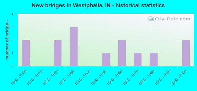
- New bridges - historical statistics
- 21900-1909
- 21920-1929
- 31930-1939
- 11950-1959
- 21960-1969
- 11970-1979
- 11980-1989
- 22000-2009

- Reconstructed bridges - Historical Statistics
- 11960-1969
- 11970-1979
- 31980-1989
- 21990-1999


- Bridge Condition - Deck
- 46.2%Good
- 30.8%Satisfactory
- 23.1%Fair

- Bridge Condition - Superstructure
- 46.2%Good
- 38.5%Satisfactory
- 15.4%Fair

- Bridge Condition - Substructure
- 7.7%Very good
- 23.1%Good
- 30.8%Satisfactory
- 38.5%Fair

- Bridge Condition - Channel
- 7.1%Very good
- 35.7%Good
- 35.7%Satisfactory
- 21.4%Fair
Find on map >> Show street view
Structure Number: 2082, Location: 01.74 W SR 67 (Lat: 38.867081, Lng: -87.252089), Route carried "on" structure: State highway 58, Year Built: 1920, Year Reconstructed: 1980, Status: Open, Structure Length: 1.49m (4.89ft), Average Daily Traffic: 593 (year 2004), Truck Traffic: 10%, Average Future Daily Traffic: 984 (year 2030), Design Load: HS 20, Features Intersected: POLLARD DITCH
Minimum Vertical Clearance: 30+ m (98+ ft), Kilometerpoint: 11.056, Lanes on structure: 2, Owner: State Highway Agency, Approaching Roadway Width: 7.3m (24.0ft), Material/Design: Prestressed concrete, Design/Construction: Box Beam or Girders - Multiple, Number Of Spans In Main Unit: 1, Length of Maximum Span: 13.7m (44.9ft), Curb or Sidewalk Widths: Left: 0.3m (1.0ft), Right: 0.3m (1.0ft), Curb-To-Curb Width: 8.7m (28.5ft), Out-to-Out Width: 9.3m (30.5ft)
Condition: Deck: Satisfactory, Superstructure: Fair, Substructure: Fair, Channel: Good, Operating Rating: 38.2 metric tons, Method Used To Determine Operating Rating: Load and Resistance Factor Rating (LRFR) rating reported by rating factor(RF) method using HL-93 loadings, Inventory Rating: 22.7 metric tons, Method Used To Determine Inventory Rating: Load and Resistance Factor Rating (LRFR) rating reported by rating factor(RF) method using HL-93 loadings, Structural Evaluation: Somewhat better than minimum adequacy, Deck Geometry: Somewhat better than minimum adequacy, Waterway Adequacy: Superior to present desirable criteria, Approach Roadway Alignment: Equal to present desirable criteria, Designated Inspection Frequency: Every 24 months, Inspection Date: November 2021, Deck Structure Type: Concrete Cast-file-Place, Wearing Surface/Protective System: Wearing Surface: Monolithic Concrete, Deck Protection: Epoxy Coated Reinforcing
Find on map >> Show street view
Structure Number: 2083, Location: 01.65 W SR 67 (Lat: 38.867089, Lng: -87.250661), Route carried "on" structure: State highway 58, Year Built: 1920, Year Reconstructed: 1980, Status: Open, Structure Length: 1.46m (4.79ft), Average Daily Traffic: 593 (year 2004), Truck Traffic: 10%, Average Future Daily Traffic: 984 (year 2030), Design Load: HS 20, Features Intersected: POLLARD DITCH
Minimum Vertical Clearance: 30+ m (98+ ft), Kilometerpoint: 11.201, Lanes on structure: 2, Owner: State Highway Agency, Approaching Roadway Width: 7.3m (24.0ft), Material/Design: Prestressed concrete, Design/Construction: Box Beam or Girders - Multiple, Number Of Spans In Main Unit: 1, Length of Maximum Span: 13.7m (44.9ft), Curb or Sidewalk Widths: Left: 0.3m (1.0ft), Right: 0.3m (1.0ft), Curb-To-Curb Width: 8.7m (28.5ft), Out-to-Out Width: 9.3m (30.5ft)
Condition: Deck: Fair, Superstructure: Satisfactory, Substructure: Satisfactory, Channel: Good, Operating Rating: 36.0 metric tons, Method Used To Determine Operating Rating: Load and Resistance Factor Rating (LRFR) rating reported by rating factor(RF) method using HL-93 loadings, Inventory Rating: 19.1 metric tons, Method Used To Determine Inventory Rating: Load and Resistance Factor Rating (LRFR) rating reported by rating factor(RF) method using HL-93 loadings, Structural Evaluation: Somewhat better than minimum adequacy, Deck Geometry: Somewhat better than minimum adequacy, Waterway Adequacy: Superior to present desirable criteria, Approach Roadway Alignment: Equal to present desirable criteria, Designated Inspection Frequency: Every 24 months, Inspection Date: November 2021, Deck Structure Type: Concrete Cast-file-Place, Wearing Surface/Protective System: Wearing Surface: Monolithic Concrete
Find on map >> Show street view
Structure Number: 2084, Location: 00.13 E SR 67 (Lat: 38.877219, Lng: -87.207239), Route carried "on" structure: State highway 58, Year Built: 1939, Year Reconstructed: 1983, Status: Open, Structure Length: 2.32m (7.61ft), Average Daily Traffic: 2,106 (year 2004), Truck Traffic: 10%, Average Future Daily Traffic: 3,497 (year 2030), Design Load: H 20, Features Intersected: GARDNER DITCH
Minimum Vertical Clearance: 30+ m (98+ ft), Kilometerpoint: 16.158, Lanes on structure: 2, Owner: State Highway Agency, Approaching Roadway Width: 9.1m (29.9ft), Skew: 2 degrees, Material/Design: Steel continuous, Design/Construction: Stringer/Multi-beam, Number Of Spans In Main Unit: 3, Length of Maximum Span: 8.8m (28.9ft), Curb-To-Curb Width: 10.4m (34.1ft), Out-to-Out Width: 11.1m (36.4ft)
Condition: Deck: Good, Superstructure: Good, Substructure: Very good, Channel: Good, Operating Rating: 51.8 metric tons, Method Used To Determine Operating Rating: Load Factor (LF), Inventory Rating: 31.0 metric tons, Method Used To Determine Inventory Rating: Load Factor (LF), Structural Evaluation: Better than present minimum criteria, Deck Geometry: Somewhat better than minimum adequacy, Waterway Adequacy: Superior to present desirable criteria, Approach Roadway Alignment: Equal to present desirable criteria, Designated Inspection Frequency: Every 24 months, Inspection Date: November 2021, Deck Structure Type: Concrete Cast-file-Place, Wearing Surface/Protective System: Wearing Surface: Monolithic Concrete
Find on map >> Show street view
Structure Number: 2374, Location: 01.19 S SR 58 (Lat: 38.848019, Lng: -87.236689), Route carried "on" structure: State highway 67, Year Built: 1932, Year Reconstructed: 1980, Status: Open, Structure Length: 3.44m (11.29ft), Average Daily Traffic: 3,557 (year 2004), Truck Traffic: 10%, Average Future Daily Traffic: 4,926 (year 2032), Design Load: H 20, Features Intersected: SPLUNGE CREEK
Minimum Vertical Clearance: 30+ m (98+ ft), Kilometerpoint: 28.807, Lanes on structure: 2, Owner: State Highway Agency, Approaching Roadway Width: 8.5m (27.9ft), Material/Design: Prestressed concrete, Design/Construction: Box Beam or Girders - Multiple, Number Of Spans In Main Unit: 1, Number Of Approach Spans: 2, Length of Maximum Span: 21.9m (71.9ft), Curb or Sidewalk Widths: Left: 0.3m (1.0ft), Right: 0.3m (1.0ft), Curb-To-Curb Width: 12.6m (41.3ft), Out-to-Out Width: 13.2m (43.3ft)
Condition: Deck: Fair, Superstructure: Good, Substructure: Satisfactory, Channel: Satisfactory, Operating Rating: 37.2 metric tons, Method Used To Determine Operating Rating: Load Factor (LF), Inventory Rating: 29.9 metric tons, Method Used To Determine Inventory Rating: Load Factor (LF), Structural Evaluation: Equal to present minimum criteria, Deck Geometry: Equal to present minimum criteria, Waterway Adequacy: Superior to present desirable criteria, Approach Roadway Alignment: Equal to present desirable criteria, Designated Inspection Frequency: Every 24 months, Inspection Date: September 2021, Deck Structure Type: Concrete Cast-file-Place, Wearing Surface/Protective System: Wearing Surface: Monolithic Concrete, Deck Protection: Epoxy Coated Reinforcing
Find on map >> Show street view
Structure Number: 2375, Location: 00.26 W SR 67 (Lat: 38.874011, Lng: -87.213489), Route carried "on" structure: State highway 58, Year Built: 1932, Year Reconstructed: 1969, Status: Open, Structure Length: 3.05m (10.01ft), Average Daily Traffic: 3,225 (year 2004), Truck Traffic: 10%, Average Future Daily Traffic: 4,468 (year 2030), Design Load: H 20, Features Intersected: SINGER DITCH
Minimum Vertical Clearance: 30+ m (98+ ft), Kilometerpoint: 15.530, Lanes on structure: 2, Owner: State Highway Agency, Approaching Roadway Width: 8.5m (27.9ft), Skew: 3 degrees, Material/Design: Concrete, Design/Construction: Culvert, Number Of Spans In Main Unit: 1, Number Of Approach Spans: 2, Length of Maximum Span: 18.3m (60.0ft), Curb or Sidewalk Widths: Left: 0.3m (1.0ft), Right: 0.3m (1.0ft), Curb-To-Curb Width: 12.5m (41.0ft), Out-to-Out Width: 13.1m (43.0ft)
Condition: Channel: Good, Culverts: Satisfactory, Operating Rating: 49.0 metric tons, Method Used To Determine Operating Rating: Field evaluation and documented engineering judgment, Inventory Rating: 29.4 metric tons, Method Used To Determine Inventory Rating: Field evaluation and documented engineering judgment, Structural Evaluation: Equal to present minimum criteria, Deck Geometry: Equal to present minimum criteria, Waterway Adequacy: Superior to present desirable criteria, Approach Roadway Alignment: Equal to present desirable criteria, Designated Inspection Frequency: Every 24 months, Inspection Date: September 2021
Find on map >> Show street view
Structure Number: 2800142, Location: 1.20 W OF CR 1425 W (Lat: 38.907831, Lng: -87.234969), Route carried "on" structure: County highway 40, Year Built: 1950, Status: Posted for load, Structure Length: 0.92m (3.02ft), Average Daily Traffic: 110 (year 2011), Truck Traffic: 3%, Average Future Daily Traffic: 140 (year 2031), Features Intersected: BRANCH OF SINGER DITCH, Facility Carried by Structure: CR 800 SOUTH
Minimum Vertical Clearance: 30+ m (98+ ft), Kilometerpoint: 0.000, Lanes on structure: 2, Owner: County Highway Agency, Approaching Roadway Width: 4.3m (14.1ft), Material/Design: Steel, Design/Construction: Stringer/Multi-beam, Number Of Spans In Main Unit: 1, Length of Maximum Span: 8.8m (28.9ft), Curb-To-Curb Width: 5.4m (17.7ft), Out-to-Out Width: 5.5m (18.0ft)
Condition: Deck: Good, Superstructure: Satisfactory, Substructure: Fair, Channel: Fair, Operating Rating: 29.4 metric tons, Method Used To Determine Operating Rating: Load Factor (LF), Inventory Rating: 17.6 metric tons, Method Used To Determine Inventory Rating: Load Factor (LF), Structural Evaluation: Somewhat better than minimum adequacy, Deck Geometry: High priority of replacement, Waterway Adequacy: Better than present minimum criteria, Approach Roadway Alignment: Equal to present desirable criteria, Bridge Posting: Required (Relationship of Operating Rating to Maximum Legal Load: 0.1 - 9.9% below), Length Of Structure Improvement: 1.22m (4.00ft), Designated Inspection Frequency: Every 24 months, Inspection Date: July 2021, Bridge Improvement Cost: $200,000, Roadway Improvement Cost: $100,000, Total Project Cost: $300,000 ( Estimate for 2021), Deck Structure Type: Open Grating
Find on map >> Show street view
Structure Number: 420003, Location: 00.14 W OF LEE PEPMIER RO (Lat: 38.889178, Lng: -87.262386), Route carried "on" structure: County highway , Year Built: 2005, Status: Open, Structure Length: 2.07m (6.79ft), Average Daily Traffic: 130 (year 2015), Truck Traffic: 1%, Average Future Daily Traffic: 170 (year 2035), Features Intersected: POLLARD DITCH, Facility Carried by Structure: GRANDVIEW ROAD
Minimum Vertical Clearance: 30+ m (98+ ft), Kilometerpoint: 0.000, Lanes on structure: 2, Owner: County Highway Agency, Approaching Roadway Width: 5.5m (18.0ft), Material/Design: Steel, Design/Construction: Stringer/Multi-beam, Number Of Spans In Main Unit: 1, Length of Maximum Span: 19.5m (64.0ft), Curb-To-Curb Width: 6.6m (21.7ft), Out-to-Out Width: 6.7m (22.0ft)
Condition: Deck: Good, Superstructure: Good, Substructure: Good, Channel: Very good, Operating Rating: 55.4 metric tons, Method Used To Determine Operating Rating: Load and Resistance Factor Rating (LRFR) rating reported by rating factor(RF) method using HL-93 loadings, Inventory Rating: 42.8 metric tons, Method Used To Determine Inventory Rating: Load and Resistance Factor Rating (LRFR) rating reported by rating factor(RF) method using HL-93 loadings, Structural Evaluation: Better than present minimum criteria, Deck Geometry: Meets minimum limits, Waterway Adequacy: Better than present minimum criteria, Approach Roadway Alignment: Equal to present minimum criteria, Designated Inspection Frequency: Every 24 months, Inspection Date: August 2021, Deck Structure Type: Concrete Cast-file-Place, Wearing Surface/Protective System: Wearing Surface: Monolithic Concrete
Find on map >> Show street view
Structure Number: 420011, Location: 00.02 E OF KOENIG ROAD (Lat: 38.833347, Lng: -87.215114), Route carried "on" structure: County highway , Year Built: 1968, Status: Open, Structure Length: 3.69m (12.11ft), Average Daily Traffic: 190 (year 2015), Truck Traffic: 3%, Average Future Daily Traffic: 250 (year 2035), Design Load: HS 20, Features Intersected: BLACK CREEK, Facility Carried by Structure: RIVERDALE ROAD
Minimum Vertical Clearance: 30+ m (98+ ft), Kilometerpoint: 0.000, Lanes on structure: 2, Owner: County Highway Agency, Approaching Roadway Width: 5.2m (17.1ft), Skew: 2 degrees, Material/Design: Prestressed concrete, Design/Construction: Box Beam or Girders - Multiple, Number Of Spans In Main Unit: 3, Length of Maximum Span: 15.9m (52.2ft), Curb or Sidewalk Widths: Left: 0.2m (0.7ft), Right: 0.2m (0.7ft), Curb-To-Curb Width: 8.5m (27.9ft), Out-to-Out Width: 9.1m (29.9ft)
Condition: Deck: Good, Superstructure: Good, Substructure: Satisfactory, Channel: Satisfactory, Operating Rating: 42.4 metric tons, Method Used To Determine Operating Rating: Load and Resistance Factor Rating (LRFR) rating reported by rating factor(RF) method using HL-93 loadings, Inventory Rating: 32.7 metric tons, Method Used To Determine Inventory Rating: Load and Resistance Factor Rating (LRFR) rating reported by rating factor(RF) method using HL-93 loadings, Structural Evaluation: Equal to present minimum criteria, Deck Geometry: Equal to present minimum criteria, Waterway Adequacy: Equal to present minimum criteria, Approach Roadway Alignment: Equal to present minimum criteria, Length Of Structure Improvement: 1.59m (5.22ft), Designated Inspection Frequency: Every 24 months, Inspection Date: September 2021, Deck Structure Type: Concrete Cast-file-Place, Wearing Surface/Protective System: Wearing Surface: Monolithic Concrete
Find on map >> Show street view
Structure Number: 4200209, Location: 00.46 E OF STATE ROAD 67 (Lat: 38.862489, Lng: -87.216200), Route carried "on" structure: County highway , Year Built: 1977, Status: Open, Structure Length: 2.38m (7.81ft), Average Daily Traffic: 190 (year 2015), Truck Traffic: 3%, Average Future Daily Traffic: 250 (year 2035), Design Load: HS 20, Features Intersected: SINGER DITCH, Facility Carried by Structure: HANCOCK ROAD
Minimum Vertical Clearance: 30+ m (98+ ft), Kilometerpoint: 0.000, Lanes on structure: 2, Owner: County Highway Agency, Approaching Roadway Width: 5.5m (18.0ft), Material/Design: Prestressed concrete, Design/Construction: Box Beam or Girders - Multiple, Number Of Spans In Main Unit: 3, Length of Maximum Span: 8.5m (27.9ft), Curb-To-Curb Width: 7.2m (23.6ft), Out-to-Out Width: 7.3m (24.0ft)
Condition: Deck: Satisfactory, Superstructure: Good, Substructure: Satisfactory, Channel: Satisfactory, Operating Rating: 31.1 metric tons, Method Used To Determine Operating Rating: Load and Resistance Factor Rating (LRFR) rating reported by rating factor(RF) method using HL-93 loadings, Inventory Rating: 19.1 metric tons, Method Used To Determine Inventory Rating: Load and Resistance Factor Rating (LRFR) rating reported by rating factor(RF) method using HL-93 loadings, Structural Evaluation: Somewhat better than minimum adequacy, Deck Geometry: Meets minimum limits, Waterway Adequacy: Equal to present minimum criteria, Approach Roadway Alignment: Equal to present minimum criteria, Designated Inspection Frequency: Every 24 months, Inspection Date: September 2021, Deck Structure Type: Concrete Precast Panels, Wearing Surface/Protective System: Wearing Surface: Bituminous
Find on map >> Show street view
Structure Number: 420021, Location: 00.91 W OF BOWMAN ROAD (Lat: 38.862439, Lng: -87.202461), Route carried "on" structure: County highway , Year Built: 1900, Year Reconstructed: 2003, Status: Posted for load, Structure Length: 3.71m (12.17ft), Average Daily Traffic: 141 (year 2021), Truck Traffic: 2%, Average Future Daily Traffic: 184 (year 2041), Features Intersected: BLACK CREEK, Facility Carried by Structure: HANCOCK ROAD
Minimum Vertical Clearance: 30+ m (98+ ft), Kilometerpoint: 0.000, Lanes on structure: 2, Owner: County Highway Agency, Approaching Roadway Width: 4.9m (16.1ft), Material/Design: Steel continuous, Design/Construction: Girder and Floorbeam System, Number Of Spans In Main Unit: 5, Length of Maximum Span: 10.4m (34.1ft), Curb-To-Curb Width: 6.2m (20.3ft), Out-to-Out Width: 6.2m (20.3ft)
Condition: Deck: Satisfactory, Superstructure: Fair, Substructure: Fair, Channel: Fair, Operating Rating: 10.0 metric tons, Method Used To Determine Operating Rating: Field evaluation and documented engineering judgment, Inventory Rating: 5.4 metric tons, Method Used To Determine Inventory Rating: Field evaluation and documented engineering judgment, Structural Evaluation: High priority of replacement, Deck Geometry: Meets minimum limits, Waterway Adequacy: Somewhat better than minimum adequacy, Approach Roadway Alignment: High priority of corrective action, Bridge Posting: Required (Relationship of Operating Rating to Maximum Legal Load: > 39.9% below), Length Of Structure Improvement: 4.57m (14.99ft), Designated Inspection Frequency: Every 24 months, Critical Feature Inspection Frequency: Every 24 months, Inspection Date: August 2021, Critical Feature Inspection Date: August 2021, Bridge Improvement Cost: $620,000, Roadway Improvement Cost: $360,000, Total Project Cost: $1,240,000 ( Estimate for 2021), Deck Structure Type: Open Grating
Find on map >> Show street view
Structure Number: 4200227, Location: 00.13 SW OF STREMMING ROA (Lat: 38.850589, Lng: -87.239372), Route carried "on" structure: County highway , Year Built: 1968, Status: Posted for load, Structure Length: 2.29m (7.51ft), Average Daily Traffic: 130 (year 2015), Truck Traffic: 2%, Average Future Daily Traffic: 170 (year 2035), Design Load: HS 20, Features Intersected: POLLARD DITCH, Facility Carried by Structure: SPANGER ROAD
Minimum Vertical Clearance: 30+ m (98+ ft), Kilometerpoint: 0.000, Lanes on structure: 2, Owner: County Highway Agency, Approaching Roadway Width: 4.6m (15.1ft), Material/Design: Prestressed concrete, Design/Construction: Box Beam or Girders - Multiple, Number Of Spans In Main Unit: 3, Length of Maximum Span: 10.7m (35.1ft), Curb or Sidewalk Widths: Left: 0.2m (0.7ft), Right: 0.2m (0.7ft), Curb-To-Curb Width: 5.8m (19.0ft), Out-to-Out Width: 6.1m (20.0ft)
Condition: Deck: Satisfactory, Superstructure: Satisfactory, Substructure: Fair, Channel: Fair, Operating Rating: 20.7 metric tons, Method Used To Determine Operating Rating: Load and Resistance Factor Rating (LRFR) rating reported by rating factor(RF) method using HL-93 loadings, Inventory Rating: 14.9 metric tons, Method Used To Determine Inventory Rating: Load and Resistance Factor Rating (LRFR) rating reported by rating factor(RF) method using HL-93 loadings, Structural Evaluation: Meets minimum limits, Deck Geometry: High priority of corrective action, Waterway Adequacy: Better than present minimum criteria, Approach Roadway Alignment: Equal to present minimum criteria, Bridge Posting: Required (Relationship of Operating Rating to Maximum Legal Load: > 39.9% below), Designated Inspection Frequency: Every 24 months, Inspection Date: September 2021, Deck Structure Type: Concrete Precast Panels, Wearing Surface/Protective System: Wearing Surface: Gravel
Find on map >> Show street view
Structure Number: 4200233, Location: 00.28 W OF STATE ROAD 67 (Lat: 38.877219, Lng: -87.214964), Route carried "on" structure: County highway , Year Built: 2006, Status: Open, Structure Length: 1.59m (5.22ft), Average Daily Traffic: 130 (year 2015), Truck Traffic: 2%, Average Future Daily Traffic: 170 (year 2035), Features Intersected: SINGER DITCH, Facility Carried by Structure: WAGNER ROAD
Minimum Vertical Clearance: 30+ m (98+ ft), Kilometerpoint: 0.000, Lanes on structure: 2, Owner: County Highway Agency, Approaching Roadway Width: 4.9m (16.1ft), Material/Design: Steel, Design/Construction: Stringer/Multi-beam, Number Of Spans In Main Unit: 1, Length of Maximum Span: 14.3m (46.9ft), Curb-To-Curb Width: 5.9m (19.4ft), Out-to-Out Width: 6.1m (20.0ft)
Condition: Deck: Good, Superstructure: Satisfactory, Substructure: Good, Channel: Good, Operating Rating: 39.2 metric tons, Method Used To Determine Operating Rating: Load and Resistance Factor Rating (LRFR) rating reported by rating factor(RF) method using HL-93 loadings, Inventory Rating: 30.1 metric tons, Method Used To Determine Inventory Rating: Load and Resistance Factor Rating (LRFR) rating reported by rating factor(RF) method using HL-93 loadings, Structural Evaluation: Equal to present minimum criteria, Deck Geometry: High priority of corrective action, Waterway Adequacy: Equal to present minimum criteria, Approach Roadway Alignment: Equal to present minimum criteria, Designated Inspection Frequency: Every 24 months, Inspection Date: September 2021, Deck Structure Type: Open Grating
Find on map >> Show street view
Structure Number: 4200234, Location: 00.45 N OF RIVERDALE ROAD (Lat: 38.839897, Lng: -87.215417), Route carried "on" structure: County highway , Year Built: 1905, Year Reconstructed: 2002, Status: Posted for load, Structure Length: 1.55m (5.09ft), Average Daily Traffic: 130 (year 2015), Truck Traffic: 2%, Average Future Daily Traffic: 170 (year 2035), Features Intersected: SINGER DITCH, Facility Carried by Structure: KOENIG ROAD
Minimum Vertical Clearance: 30+ m (98+ ft), Kilometerpoint: 0.000, Lanes on structure: 2, Owner: County Highway Agency, Approaching Roadway Width: 4.6m (15.1ft), Skew: 1 degrees, Material/Design: Steel, Design/Construction: Stringer/Multi-beam, Number Of Spans In Main Unit: 1, Length of Maximum Span: 14.5m (47.6ft), Curb-To-Curb Width: 5.8m (19.0ft), Out-to-Out Width: 6.0m (19.7ft)
Condition: Deck: Good, Superstructure: Good, Substructure: Good, Channel: Satisfactory, Operating Rating: 27.9 metric tons, Method Used To Determine Operating Rating: Load and Resistance Factor Rating (LRFR) rating reported by rating factor(RF) method using HL-93 loadings, Inventory Rating: 21.7 metric tons, Method Used To Determine Inventory Rating: Load and Resistance Factor Rating (LRFR) rating reported by rating factor(RF) method using HL-93 loadings, Structural Evaluation: Equal to present minimum criteria, Deck Geometry: High priority of corrective action, Waterway Adequacy: Somewhat better than minimum adequacy, Approach Roadway Alignment: Equal to present minimum criteria, Bridge Posting: Required (Relationship of Operating Rating to Maximum Legal Load: 20.0 - 29.9% below), Designated Inspection Frequency: Every 24 months, Inspection Date: September 2021, Deck Structure Type: Concrete Cast-file-Place, Wearing Surface/Protective System: Wearing Surface: Monolithic Concrete
Find on map >> Show street view
Structure Number: 4200235, Location: 00.94 W OF SPRANGER RD (Lat: 38.855919, Lng: -87.254861), Route carried "on" structure: County highway , Year Built: 1989, Status: Posted for load, Structure Length: 2.62m (8.60ft), Average Daily Traffic: 80 (year 2015), Truck Traffic: 1%, Average Future Daily Traffic: 110 (year 2035), Features Intersected: POLLARD DITCH, Facility Carried by Structure: JOHANNINGSMEIR RD
Minimum Vertical Clearance: 30+ m (98+ ft), Kilometerpoint: 0.000, Lanes on structure: 2, Owner: County Highway Agency, Approaching Roadway Width: 4.6m (15.1ft), Material/Design: Steel, Number Of Spans In Main Unit: 1, Length of Maximum Span: 19.8m (65.0ft), Curb-To-Curb Width: 5.4m (17.7ft), Out-to-Out Width: 5.6m (18.4ft)
Condition: Deck: Fair, Superstructure: Satisfactory, Substructure: Fair, Channel: Satisfactory, Operating Rating: 28.1 metric tons, Method Used To Determine Operating Rating: Field evaluation and documented engineering judgment, Inventory Rating: 19.0 metric tons, Method Used To Determine Inventory Rating: Field evaluation and documented engineering judgment, Structural Evaluation: Somewhat better than minimum adequacy, Deck Geometry: High priority of corrective action, Waterway Adequacy: Somewhat better than minimum adequacy, Approach Roadway Alignment: Equal to present minimum criteria, Bridge Posting: Required (Relationship of Operating Rating to Maximum Legal Load: 10.0 - 19.9% below), Designated Inspection Frequency: Every 24 months, Critical Feature Inspection Frequency: Every 24 months, Inspection Date: September 2021, Critical Feature Inspection Date: September 2021, Deck Structure Type: Steel plate, Wearing Surface/Protective System: Wearing Surface: Gravel