Bridge Statistics for Wheatfield, New York (NY)
Condition, Traffic, Stress, Structural Evaluation, Project Costs
- National Bridge Inventory (NBI) Statistics
- 23Number of bridges
- 95ft / 28.9mTotal length
- $27,296,000Total costs
- 124,260Total average daily traffic
- 3,629Total average daily truck traffic
- National Bridge Inventory (NBI) Registered Bridges for Wheatfield
- No street view available for this location
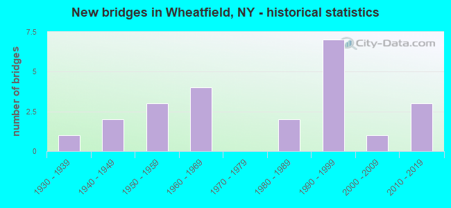
- New bridges - historical statistics
- 11930-1939
- 21940-1949
- 31950-1959
- 41960-1969
- 21980-1989
- 71990-1999
- 12000-2009
- 32010-2019
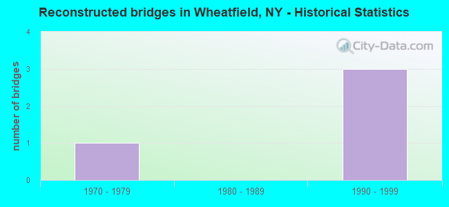
- Reconstructed bridges - Historical Statistics
- 11970-1979
- 01980-1989
- 31990-1999
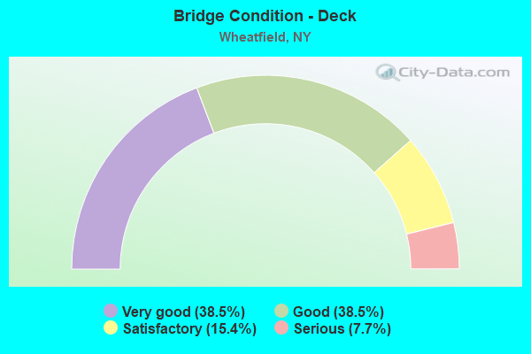
- Bridge Condition - Deck
- 38.5%Very good
- 38.5%Good
- 15.4%Satisfactory
- 7.7%Serious
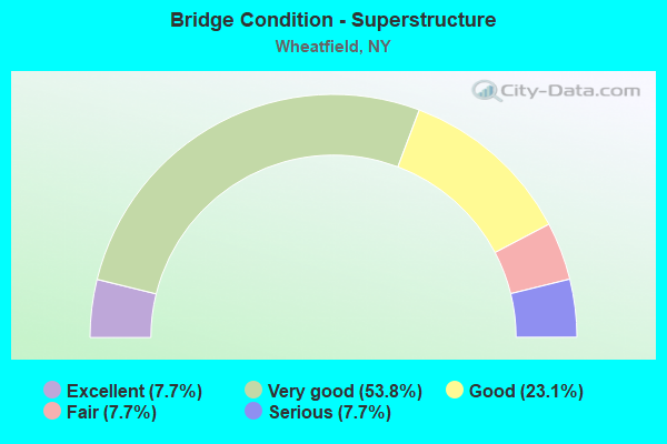
- Bridge Condition - Superstructure
- 7.7%Excellent
- 53.8%Very good
- 23.1%Good
- 7.7%Fair
- 7.7%Serious
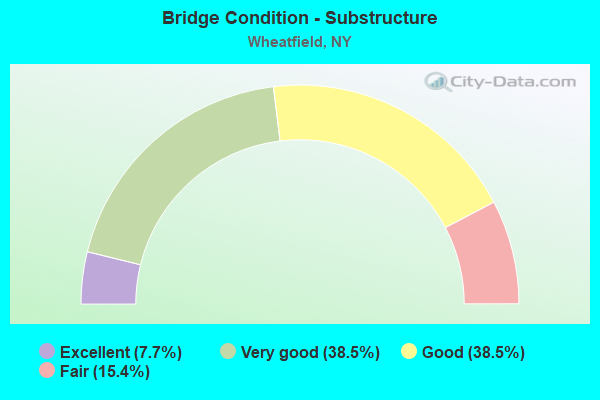
- Bridge Condition - Substructure
- 7.7%Excellent
- 38.5%Very good
- 38.5%Good
- 15.4%Fair
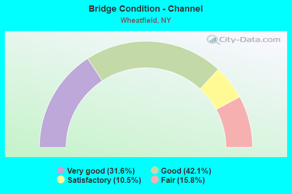
- Bridge Condition - Channel
- 31.6%Very good
- 42.1%Good
- 10.5%Satisfactory
- 15.8%Fair
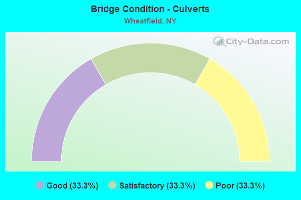
- Bridge Condition - Culverts
- 33.3%Good
- 33.3%Satisfactory
- 33.3%Poor
Find on map >> Show street view
Structure Number: 102852, Location: 0.3 MI S JCT RTS 62 & 425 (Lat: 43.056578, Lng: -78.831194), Route carried "on" structure: US 62, Year Built: 1998, Status: Open, Structure Length: 3.47m (11.38ft), Average Daily Traffic: 24,259 (year 2019), Truck Traffic: 2%, Average Future Daily Traffic: 24,373 (year 2040), Design Load: HS 25 or greater, Features Intersected: SAWYER CREEK
Minimum Vertical Clearance: 30+ m (98+ ft), Kilometerpoint: 0.660, Lanes on structure: 4, Base Highway Network: Yes, Owner: State Highway Agency, Approaching Roadway Width: 21.9m (71.9ft), Skew: 4 degrees, Material/Design: Steel, Design/Construction: Stringer/Multi-beam, Number Of Spans In Main Unit: 1, Length of Maximum Span: 33.2m (108.9ft), Curb or Sidewalk Widths: Left: 1.5m (4.9ft), Right: 0.0m, Curb-To-Curb Width: 21.9m (71.9ft), Out-to-Out Width: 24.1m (79.1ft)
Condition: Deck: Good, Superstructure: Very good, Substructure: Good, Channel: Very good, Operating Rating: 75.3 metric tons, Method Used To Determine Operating Rating: Load Factor (LF), Inventory Rating: 45.4 metric tons, Method Used To Determine Inventory Rating: Load Factor (LF), Structural Evaluation: Better than present minimum criteria, Deck Geometry: Superior to present desirable criteria, Waterway Adequacy: Equal to present minimum criteria, Approach Roadway Alignment: Equal to present desirable criteria, Length Of Structure Improvement: 3.47m (11.38ft), Designated Inspection Frequency: Every 24 months, Inspection Date: May 2020, Bridge Improvement Cost: $4,323,000, Roadway Improvement Cost: $2,532,000, Total Project Cost: $6,855,000 ( Estimate for 2021), Deck Structure Type: Concrete Cast-file-Place, Wearing Surface/Protective System: Wearing Surface: Monolithic Concrete, Deck Protection: Epoxy Coated Reinforcing
Find on map >> Show street view
Structure Number: 102854, Location: 2.3 MI NW JCT RTS 62 +429 (Lat: 43.098714, Lng: -78.925100), Route carried "on" structure: US 62, Year Built: 2012, Status: Open, Structure Length: 1.74m (5.71ft), Average Daily Traffic: 15,249 (year 2018), Truck Traffic: 4%, Average Future Daily Traffic: 15,320 (year 2040), Design Load: HL 93, Features Intersected: BERGHOLTZ CREEK
Minimum Vertical Clearance: 30+ m (98+ ft), Kilometerpoint: 9.863, Lanes on structure: 4, Base Highway Network: Yes, Owner: State Highway Agency, Approaching Roadway Width: 21.0m (68.9ft), Skew: 24 degrees, Material/Design: Steel, Design/Construction: Stringer/Multi-beam, Number Of Spans In Main Unit: 1, Length of Maximum Span: 17.1m (56.1ft), Curb or Sidewalk Widths: Left: 1.7m (5.6ft), Right: 0.0m, Curb-To-Curb Width: 21.0m (68.9ft), Out-to-Out Width: 23.5m (77.1ft)
Condition: Deck: Very good, Superstructure: Very good, Substructure: Very good, Channel: Very good, Operating Rating: 62.2 metric tons, Method Used To Determine Operating Rating: Load and Resistance Factor Rating (LRFR) rating reported by rating factor(RF) method using HL-93 loadings, Inventory Rating: 48.0 metric tons, Method Used To Determine Inventory Rating: Load and Resistance Factor Rating (LRFR) rating reported by rating factor(RF) method using HL-93 loadings, Structural Evaluation: Equal to present desirable criteria, Deck Geometry: Superior to present desirable criteria, Waterway Adequacy: Equal to present desirable criteria, Approach Roadway Alignment: Equal to present desirable criteria, Length Of Structure Improvement: 1.73m (5.68ft), Designated Inspection Frequency: Every 24 months, Inspection Date: October 2020, Bridge Improvement Cost: $2,483,000, Roadway Improvement Cost: $1,454,000, Total Project Cost: $3,938,000 ( Estimate for 2021), Deck Structure Type: Concrete Cast-file-Place, Wearing Surface/Protective System: Wearing Surface: Integral Concrete, Deck Protection: Epoxy Coated Reinforcing
Find on map >> Show street view
Structure Number: 104833, Location: AT JCT RTS 62 & 425 (Lat: 43.059275, Lng: -78.836953), Route carried "on" structure: State highway 425, Year Built: 1997, Status: Open, Structure Length: 0.67m (2.20ft), Average Daily Traffic: 8,320 (year 2020), Truck Traffic: 5%, Average Future Daily Traffic: 8,785 (year 2040), Design Load: HS 25 or greater, Features Intersected: SAWYER CREEK
Minimum Vertical Clearance: 30+ m (98+ ft), Kilometerpoint: 4.972, Lanes on structure: 4, Base Highway Network: Yes, Owner: State Highway Agency, Approaching Roadway Width: 18.5m (60.7ft), Skew: 1 degrees, Material/Design: Concrete, Design/Construction: Culvert, Number Of Spans In Main Unit: 1, Length of Maximum Span: 6.4m (21.0ft)
Condition: Channel: Very good, Culverts: Good, Operating Rating: 68.0 metric tons, Method Used To Determine Operating Rating: Load Factor (LF), Inventory Rating: 40.8 metric tons, Method Used To Determine Inventory Rating: Load Factor (LF), Structural Evaluation: Better than present minimum criteria, Waterway Adequacy: Equal to present minimum criteria, Approach Roadway Alignment: Equal to present desirable criteria, Length Of Structure Improvement: 0.67m (2.20ft), Designated Inspection Frequency: Every 24 months, Inspection Date: April 2021, Bridge Improvement Cost: $356,000, Roadway Improvement Cost: $208,000, Total Project Cost: $564,000 ( Estimate for 2021)
Find on map >> Show street view
Structure Number: 104844, Location: 1.8 MI S JCT RTS 429 & 31 (Lat: 43.117397, Lng: -78.889850), Route carried "on" structure: State highway 429, Year Built: 1997, Status: Open, Structure Length: 1.10m (3.61ft), Average Daily Traffic: 9,362 (year 2020), Truck Traffic: 6%, Average Future Daily Traffic: 9,886 (year 2040), Features Intersected: BERGHOLTZ CREEK
Minimum Vertical Clearance: 30+ m (98+ ft), Kilometerpoint: 9.783, Lanes on structure: 2, Base Highway Network: Yes, Owner: State Highway Agency, Approaching Roadway Width: 11.9m (39.0ft), Skew: 3 degrees, Material/Design: Concrete, Design/Construction: Frame, Number Of Spans In Main Unit: 1, Length of Maximum Span: 10.3m (33.8ft), Curb-To-Curb Width: 12.0m (39.4ft), Out-to-Out Width: 12.9m (42.3ft)
Condition: Deck: Very good, Superstructure: Very good, Substructure: Very good, Channel: Good, Operating Rating: 69.9 metric tons, Method Used To Determine Operating Rating: Load Factor (LF), Inventory Rating: 41.7 metric tons, Method Used To Determine Inventory Rating: Load Factor (LF), Structural Evaluation: Equal to present desirable criteria, Deck Geometry: Somewhat better than minimum adequacy, Waterway Adequacy: Equal to present desirable criteria, Approach Roadway Alignment: Equal to present desirable criteria, Length Of Structure Improvement: 1.09m (3.58ft), Designated Inspection Frequency: Every 24 months, Inspection Date: May 2020, Bridge Improvement Cost: $847,000, Roadway Improvement Cost: $496,000, Total Project Cost: $1,343,000 ( Estimate for 2021), Wearing Surface/Protective System: Wearing Surface: Bituminous, Membrane: Other
Find on map >> Show street view
Structure Number: 22137, Location: 0.7 MI NW JCT RT 62 & 425 (Lat: 43.065775, Lng: -78.844858), Route carried "on" structure: Other road , Year Built: 1997, Status: Open, Structure Length: 0.70m (2.30ft), Average Daily Traffic: 707 (year 2019), Truck Traffic: 3%, Average Future Daily Traffic: 990 (year 2039), Design Load: HS 25 or greater, Features Intersected: SAWYER CREEK, Facility Carried by Structure: KLEMER ROAD
Minimum Vertical Clearance: 30+ m (98+ ft), Kilometerpoint: 0.016, Lanes on structure: 2, Owner: Town or Township Highway Agency, Approaching Roadway Width: 9.1m (29.9ft), Skew: 1 degrees, Material/Design: Concrete, Design/Construction: Culvert, Number Of Spans In Main Unit: 1, Length of Maximum Span: 6.4m (21.0ft), Curb-To-Curb Width: 9.2m (30.2ft), Out-to-Out Width: 13.0m (42.7ft)
Condition: Channel: Good, Culverts: Satisfactory, Operating Rating: 99.8 metric tons, Method Used To Determine Operating Rating: Load Factor (LF), Inventory Rating: 59.9 metric tons, Method Used To Determine Inventory Rating: Load Factor (LF), Structural Evaluation: Equal to present minimum criteria, Deck Geometry: Equal to present minimum criteria, Waterway Adequacy: Equal to present desirable criteria, Approach Roadway Alignment: Equal to present desirable criteria, Length Of Structure Improvement: 0.70m (2.30ft), Designated Inspection Frequency: Every 24 months, Inspection Date: May 2020, Bridge Improvement Cost: $252,000, Roadway Improvement Cost: $148,000, Total Project Cost: $399,000 ( Estimate for 2021), Wearing Surface/Protective System: Wearing Surface: Bituminous, Membrane: Other
Find on map >> Show street view
Structure Number: 225731, Location: .6 MI. E OF NIAGARA FALLS (Lat: 43.098000, Lng: -78.927986), Route carried "on" structure: Other road , Year Built: 1958, Status: Open, Structure Length: 1.22m (4.00ft), Average Daily Traffic: 700 (year 2020), Truck Traffic: 1%, Average Future Daily Traffic: 980 (year 2040), Design Load: H 20, Features Intersected: BERGHOLTZ CREEK, Facility Carried by Structure: CAYUGA DR EXT
Minimum Vertical Clearance: 30+ m (98+ ft), Kilometerpoint: 1.448, Lanes on structure: 2, Owner: Town or Township Highway Agency, Approaching Roadway Width: 7.0m (23.0ft), Skew: 4 degrees, Material/Design: Steel, Design/Construction: Culvert, Number Of Spans In Main Unit: 3, Length of Maximum Span: 4.0m (13.1ft)
Condition: Channel: Satisfactory, Culverts: Satisfactory, Operating Rating: 72.8 metric tons, Method Used To Determine Operating Rating: Field evaluation and documented engineering judgment, Inventory Rating: 32.7 metric tons, Method Used To Determine Inventory Rating: Field evaluation and documented engineering judgment, Structural Evaluation: Equal to present minimum criteria, Waterway Adequacy: Better than present minimum criteria, Approach Roadway Alignment: Equal to present desirable criteria, Length Of Structure Improvement: 1.21m (3.97ft), Designated Inspection Frequency: Every 24 months, Inspection Date: October 2020, Bridge Improvement Cost: $236,000, Roadway Improvement Cost: $138,000, Total Project Cost: $374,000 ( Estimate for 2021)
Find on map >> Show street view
Structure Number: 226701, Location: 0.5 MI SE JCT RTS 62&182 (Lat: 43.095764, Lng: -78.934031), Route carried "on" structure: Other road , Year Built: 1981, Status: Posted for load, Structure Length: 1.71m (5.61ft), Average Daily Traffic: 1,154 (year 2020), Truck Traffic: 2%, Average Future Daily Traffic: 1,616 (year 2040), Design Load: HS 20, Features Intersected: BERGHOLTZ CREEK, Facility Carried by Structure: PLAZA DRIVE
Minimum Vertical Clearance: 30+ m (98+ ft), Kilometerpoint: 1.335, Lanes on structure: 2, Owner: Town or Township Highway Agency, Approaching Roadway Width: 7.3m (24.0ft), Material/Design: Steel, Design/Construction: Culvert, Number Of Spans In Main Unit: 2, Length of Maximum Span: 7.9m (25.9ft)
Condition: Channel: Fair, Culverts: Poor, Operating Rating: 9.1 metric tons, Method Used To Determine Operating Rating: Field evaluation and documented engineering judgment, Inventory Rating: 9.1 metric tons, Method Used To Determine Inventory Rating: Field evaluation and documented engineering judgment, Structural Evaluation: High priority of corrective action, Waterway Adequacy: Superior to present desirable criteria, Approach Roadway Alignment: Equal to present desirable criteria, Bridge Posting: Required (Relationship of Operating Rating to Maximum Legal Load: > 39.9% below), Length Of Structure Improvement: 1.70m (5.58ft), Designated Inspection Frequency: Every 12 months, Inspection Date: July 2021, Bridge Improvement Cost: $402,000, Roadway Improvement Cost: $235,000, Total Project Cost: $637,000 ( Estimate for 2021)
Find on map >> Show street view
Structure Number: 22688, Location: 1 MI N OF WARD RD & RT 62 (Lat: 43.102181, Lng: -78.890408), Route carried "on" structure: Other road , Year Built: 1993, Status: Open, Structure Length: 1.77m (5.81ft), Average Daily Traffic: 351 (year 2020), Truck Traffic: 2%, Average Future Daily Traffic: 491 (year 2040), Design Load: H 20, Features Intersected: BERGHOLTZ CREEK, Facility Carried by Structure: THORNWOODS DRIVE
Minimum Vertical Clearance: 30+ m (98+ ft), Kilometerpoint: 0.708, Lanes on structure: 2, Owner: Town or Township Highway Agency, Approaching Roadway Width: 9.1m (29.9ft), Material/Design: Concrete, Design/Construction: Culvert, Number Of Spans In Main Unit: 5, Length of Maximum Span: 3.3m (10.8ft), Curb or Sidewalk Widths: Left: 0.5m (1.6ft), Right: 0.5m (1.6ft), Curb-To-Curb Width: 7.3m (24.0ft), Out-to-Out Width: 9.2m (30.2ft)
Condition: Channel: Fair, Culverts: Poor, Operating Rating: 31.1 metric tons, Method Used To Determine Operating Rating: Load and Resistance Factor Rating (LRFR) rating reported by rating factor(RF) method using HL-93 loadings, Inventory Rating: 24.0 metric tons, Method Used To Determine Inventory Rating: Load and Resistance Factor Rating (LRFR) rating reported by rating factor(RF) method using HL-93 loadings, Structural Evaluation: Meets minimum limits, Deck Geometry: Somewhat better than minimum adequacy, Waterway Adequacy: Equal to present desirable criteria, Approach Roadway Alignment: Equal to present desirable criteria, Length Of Structure Improvement: 1.76m (5.77ft), Designated Inspection Frequency: Every 24 months, Inspection Date: April 2020, Bridge Improvement Cost: $523,000, Roadway Improvement Cost: $307,000, Total Project Cost: $830,000 ( Estimate for 2021), Wearing Surface/Protective System: Wearing Surface: Bituminous
Find on map >> Show street view
Structure Number: 332918, Location: 2.7 MI N OF N TONAWANDA (Lat: 43.079047, Lng: -78.825267), Route carried "on" structure: Other road , Year Built: 1990, Status: Open, Structure Length: 1.62m (5.31ft), Average Daily Traffic: 1,594 (year 2020), Truck Traffic: 4%, Average Future Daily Traffic: 1,972 (year 2040), Design Load: HS 20, Features Intersected: BULL CREEK, Facility Carried by Structure: HILL ROAD
Minimum Vertical Clearance: 30+ m (98+ ft), Kilometerpoint: 0.853, Lanes on structure: 2, Owner: County Highway Agency, Approaching Roadway Width: 8.5m (27.9ft), Skew: 1 degrees, Material/Design: Prestressed concrete, Design/Construction: Box Beam or Girders - Multiple, Number Of Spans In Main Unit: 1, Length of Maximum Span: 15.5m (50.9ft), Curb-To-Curb Width: 8.5m (27.9ft), Out-to-Out Width: 9.1m (29.9ft)
Condition: Deck: Good, Superstructure: Very good, Substructure: Very good, Channel: Good, Operating Rating: 57.2 metric tons, Method Used To Determine Operating Rating: Load Factor (LF), Inventory Rating: 35.4 metric tons, Method Used To Determine Inventory Rating: Load Factor (LF), Structural Evaluation: Equal to present desirable criteria, Deck Geometry: Somewhat better than minimum adequacy, Waterway Adequacy: Meets minimum limits, Approach Roadway Alignment: Equal to present desirable criteria, Length Of Structure Improvement: 1.61m (5.28ft), Designated Inspection Frequency: Every 24 months, Inspection Date: April 2020, Bridge Improvement Cost: $403,000, Roadway Improvement Cost: $236,000, Total Project Cost: $639,000 ( Estimate for 2021), Deck Structure Type: Concrete Cast-file-Place, Wearing Surface/Protective System: Wearing Surface: Integral Concrete
Find on map >> Show street view
Structure Number: 33292, Location: 1.3 MI NW OF ST JOHNSBURG (Lat: 43.101469, Lng: -78.906581), Route carried "on" structure: Other road , Year Built: 1940, Year Reconstructed: 1977, Status: Closed, Structure Length: 1.10m (3.61ft), Average Daily Traffic: 84 (year 2014), Truck Traffic: 11%, Average Future Daily Traffic: 118 (year 2034), Design Load: H 15, Features Intersected: BERGHOLTZ CREEK, Facility Carried by Structure: HUNT STREET
Minimum Vertical Clearance: 30+ m (98+ ft), Kilometerpoint: 0.129, Lanes on structure: 2, Owner: County Highway Agency, Approaching Roadway Width: 5.5m (18.0ft), Material/Design: Wood or Timber, Design/Construction: Slab, Number Of Spans In Main Unit: 2, Length of Maximum Span: 5.1m (16.7ft), Curb-To-Curb Width: 7.2m (23.6ft), Out-to-Out Width: 7.6m (24.9ft)
Condition: Deck: Serious, Superstructure: Serious, Substructure: Fair, Channel: Fair, Deck Geometry: Somewhat better than minimum adequacy, Waterway Adequacy: Better than present minimum criteria, Approach Roadway Alignment: Equal to present desirable criteria, Bridge Posting: Required (Relationship of Operating Rating to Maximum Legal Load: > 39.9% below), Length Of Structure Improvement: 1.09m (3.58ft), Designated Inspection Frequency: Every 12 months, Inspection Date: April 2021, Bridge Improvement Cost: $534,000, Roadway Improvement Cost: $313,000, Total Project Cost: $847,000 ( Estimate for 2021), Wearing Surface/Protective System: Wearing Surface: Bituminous
Find on map >> Show street view
Structure Number: 332926, Location: 1 MI NE OF N TONAWANDA (Lat: 43.051089, Lng: -78.831194), Route carried "on" structure: County highway , Year Built: 1986, Status: Open, Structure Length: 2.59m (8.50ft), Average Daily Traffic: 1,665 (year 2017), Truck Traffic: 3%, Average Future Daily Traffic: 2,060 (year 2040), Design Load: HS 20, Features Intersected: SAWYER CREEK, Facility Carried by Structure: LOCKPORT AVENUE
Minimum Vertical Clearance: 30+ m (98+ ft), Kilometerpoint: 0.097, Lanes on structure: 2, Owner: County Highway Agency, Approaching Roadway Width: 9.1m (29.9ft), Material/Design: Prestressed concrete, Design/Construction: Box Beam or Girders - Multiple, Number Of Spans In Main Unit: 1, Length of Maximum Span: 24.3m (79.7ft), Curb or Sidewalk Widths: Left: 1.5m (4.9ft), Right: 0.0m, Curb-To-Curb Width: 9.1m (29.9ft), Out-to-Out Width: 11.7m (38.4ft)
Condition: Deck: Satisfactory, Superstructure: Good, Substructure: Good, Channel: Very good, Operating Rating: 83.5 metric tons, Method Used To Determine Operating Rating: Load Factor (LF), Inventory Rating: 42.6 metric tons, Method Used To Determine Inventory Rating: Load Factor (LF), Structural Evaluation: Better than present minimum criteria, Deck Geometry: Somewhat better than minimum adequacy, Waterway Adequacy: Superior to present desirable criteria, Approach Roadway Alignment: Equal to present desirable criteria, Length Of Structure Improvement: 2.59m (8.50ft), Designated Inspection Frequency: Every 24 months, Inspection Date: September 2020, Bridge Improvement Cost: $1,012,000, Roadway Improvement Cost: $593,000, Total Project Cost: $1,604,000 ( Estimate for 2021), Deck Structure Type: Concrete Cast-file-Place, Wearing Surface/Protective System: Wearing Surface: Integral Concrete, Deck Protection: Epoxy Coated Reinforcing
Find on map >> Show street view
Structure Number: 332929, Location: 1.3 MI SOUTH OF SANBORN (Lat: 43.121258, Lng: -78.883372), Route carried "on" structure: County highway , Year Built: 2014, Status: Open, Structure Length: 1.34m (4.40ft), Average Daily Traffic: 10,267 (year 2020), Truck Traffic: 8%, Average Future Daily Traffic: 10,841 (year 2040), Design Load: HS 25 or greater, Features Intersected: BERGHOLTZ CREEK, Facility Carried by Structure: LOCKPORT ROAD
Minimum Vertical Clearance: 30+ m (98+ ft), Kilometerpoint: 9.493, Lanes on structure: 2, Owner: County Highway Agency, Approaching Roadway Width: 12.2m (40.0ft), Material/Design: Concrete, Design/Construction: Culvert, Number Of Spans In Main Unit: 2, Length of Maximum Span: 6.1m (20.0ft), Curb-To-Curb Width: 12.3m (40.4ft), Out-to-Out Width: 13.4m (44.0ft)
Condition: Channel: Good, Culverts: Good, Operating Rating: 76.9 metric tons, Method Used To Determine Operating Rating: Field evaluation and documented engineering judgment, Inventory Rating: 40.8 metric tons, Method Used To Determine Inventory Rating: Field evaluation and documented engineering judgment, Structural Evaluation: Better than present minimum criteria, Deck Geometry: Somewhat better than minimum adequacy, Waterway Adequacy: Equal to present desirable criteria, Approach Roadway Alignment: Equal to present desirable criteria, Length Of Structure Improvement: 1.34m (4.40ft), Designated Inspection Frequency: Every 24 months, Inspection Date: April 2020, Bridge Improvement Cost: $495,000, Roadway Improvement Cost: $290,000, Total Project Cost: $784,000 ( Estimate for 2021), Wearing Surface/Protective System: Wearing Surface: Bituminous
Find on map >> Show street view
Structure Number: 33293, Location: 3.1 MI SOUTH OF SHAWNEE (Lat: 43.084864, Lng: -78.827131), Route carried "on" structure: County highway , Year Built: 1937, Year Reconstructed: 2003, Status: Open, Structure Length: 1.22m (4.00ft), Average Daily Traffic: 956 (year 2017), Truck Traffic: 6%, Average Future Daily Traffic: 1,338 (year 2037), Design Load: HS 25 or greater, Features Intersected: BULL CREEK, Facility Carried by Structure: LOVELAND ROAD
Minimum Vertical Clearance: 30+ m (98+ ft), Kilometerpoint: 0.708, Lanes on structure: 2, Owner: County Highway Agency, Approaching Roadway Width: 10.4m (34.1ft), Material/Design: Prestressed concrete, Design/Construction: Box Beam or Girders - Multiple, Number Of Spans In Main Unit: 1, Length of Maximum Span: 11.9m (39.0ft), Curb-To-Curb Width: 10.5m (34.4ft), Out-to-Out Width: 11.3m (37.1ft)
Condition: Deck: Very good, Superstructure: Very good, Substructure: Good, Channel: Good, Operating Rating: 62.5 metric tons, Method Used To Determine Operating Rating: Load and Resistance Factor Rating (LRFR) rating reported by rating factor(RF) method using HL-93 loadings, Inventory Rating: 48.3 metric tons, Method Used To Determine Inventory Rating: Load and Resistance Factor Rating (LRFR) rating reported by rating factor(RF) method using HL-93 loadings, Structural Evaluation: Better than present minimum criteria, Deck Geometry: Equal to present minimum criteria, Waterway Adequacy: Equal to present minimum criteria, Approach Roadway Alignment: Equal to present desirable criteria, Length Of Structure Improvement: 1.21m (3.97ft), Designated Inspection Frequency: Every 24 months, Inspection Date: October 2021, Bridge Improvement Cost: $569,000, Roadway Improvement Cost: $333,000, Total Project Cost: $903,000 ( Estimate for 2021), Deck Structure Type: Concrete Cast-file-Place, Wearing Surface/Protective System: Wearing Surface: Integral Concrete
Find on map >> Show street view
Structure Number: 332934, Location: 1.4 MI NW OF ST JOHNSBURG (Lat: 43.101728, Lng: -78.910558), Route carried "on" structure: Other road , Year Built: 1947, Year Reconstructed: 1996, Status: Open, Structure Length: 1.46m (4.79ft), Average Daily Traffic: 391 (year 2018), Truck Traffic: 4%, Average Future Daily Traffic: 547 (year 2038), Features Intersected: BERGHOLTZ CREEK, Facility Carried by Structure: LUTHER STREET
Minimum Vertical Clearance: 30+ m (98+ ft), Kilometerpoint: 0.547, Lanes on structure: 2, Owner: County Highway Agency, Approaching Roadway Width: 7.3m (24.0ft), Material/Design: Prestressed concrete, Design/Construction: Box Beam or Girders - Multiple, Number Of Spans In Main Unit: 1, Length of Maximum Span: 14.0m (45.9ft), Curb-To-Curb Width: 9.1m (29.9ft), Out-to-Out Width: 10.1m (33.1ft)
Condition: Deck: Good, Superstructure: Good, Substructure: Good, Channel: Good, Operating Rating: 91.6 metric tons, Method Used To Determine Operating Rating: Load Factor (LF), Inventory Rating: 49.0 metric tons, Method Used To Determine Inventory Rating: Load Factor (LF), Structural Evaluation: Better than present minimum criteria, Deck Geometry: Equal to present minimum criteria, Waterway Adequacy: Better than present minimum criteria, Approach Roadway Alignment: Equal to present desirable criteria, Length Of Structure Improvement: 1.46m (4.79ft), Designated Inspection Frequency: Every 24 months, Inspection Date: August 2020, Bridge Improvement Cost: $482,000, Roadway Improvement Cost: $282,000, Total Project Cost: $765,000 ( Estimate for 2021), Deck Structure Type: Concrete Cast-file-Place, Wearing Surface/Protective System: Wearing Surface: Integral Concrete, Deck Protection: Epoxy Coated Reinforcing
Find on map >> Show street view
Structure Number: 332941, Location: 1.2 MI N OF ST JOHNSBURG (Lat: 43.104117, Lng: -78.892014), Route carried "on" structure: County highway , Year Built: 2018, Status: Open, Structure Length: 1.07m (3.51ft), Average Daily Traffic: 2,429 (year 2020), Truck Traffic: 5%, Average Future Daily Traffic: 3,005 (year 2040), Design Load: HL 93, Features Intersected: BERGHOLTZ CREEK, Facility Carried by Structure: NIAGARA ROAD
Minimum Vertical Clearance: 30+ m (98+ ft), Kilometerpoint: 2.961, Lanes on structure: 2, Owner: County Highway Agency, Approaching Roadway Width: 12.2m (40.0ft), Skew: 2 degrees, Material/Design: Concrete, Design/Construction: Frame, Number Of Spans In Main Unit: 1, Length of Maximum Span: 10.0m (32.8ft), Curb-To-Curb Width: 12.2m (40.0ft), Out-to-Out Width: 13.2m (43.3ft)
Condition: Deck: Very good, Superstructure: Very good, Substructure: Excellent, Channel: Very good, Operating Rating: 50.2 metric tons, Method Used To Determine Operating Rating: Load and Resistance Factor Rating (LRFR) rating reported by rating factor(RF) method using HL-93 loadings, Inventory Rating: 38.9 metric tons, Method Used To Determine Inventory Rating: Load and Resistance Factor Rating (LRFR) rating reported by rating factor(RF) method using HL-93 loadings, Structural Evaluation: Equal to present desirable criteria, Deck Geometry: Equal to present minimum criteria, Waterway Adequacy: Somewhat better than minimum adequacy, Approach Roadway Alignment: Equal to present desirable criteria, Length Of Structure Improvement: 1.06m (3.48ft), Designated Inspection Frequency: Every 24 months, Inspection Date: May 2021, Bridge Improvement Cost: $639,000, Roadway Improvement Cost: $374,000, Total Project Cost: $1,012,000 ( Estimate for 2021)
Find on map >> Show street view
Structure Number: 332954, Location: 1.6 MI NW OF ST JOHNSBURG (Lat: 43.101653, Lng: -78.913908), Route carried "on" structure: Other road , Year Built: 2007, Status: Open, Structure Length: 1.43m (4.69ft), Average Daily Traffic: 268 (year 2018), Truck Traffic: 4%, Average Future Daily Traffic: 375 (year 2038), Design Load: HS 25 or greater, Features Intersected: BERGHOLTZ CREEK, Facility Carried by Structure: ROHR STREET
Minimum Vertical Clearance: 30+ m (98+ ft), Kilometerpoint: 0.241, Lanes on structure: 2, Owner: County Highway Agency, Approaching Roadway Width: 7.0m (23.0ft), Material/Design: Prestressed concrete, Design/Construction: Box Beam or Girders - Multiple, Number Of Spans In Main Unit: 1, Length of Maximum Span: 14.0m (45.9ft), Curb-To-Curb Width: 9.3m (30.5ft), Out-to-Out Width: 10.1m (33.1ft)
Condition: Deck: Very good, Superstructure: Excellent, Substructure: Very good, Channel: Good, Operating Rating: 47.3 metric tons, Method Used To Determine Operating Rating: Load and Resistance Factor Rating (LRFR) rating reported by rating factor(RF) method using HL-93 loadings, Inventory Rating: 36.6 metric tons, Method Used To Determine Inventory Rating: Load and Resistance Factor Rating (LRFR) rating reported by rating factor(RF) method using HL-93 loadings, Structural Evaluation: Equal to present desirable criteria, Deck Geometry: Equal to present minimum criteria, Waterway Adequacy: Equal to present desirable criteria, Approach Roadway Alignment: Equal to present desirable criteria, Length Of Structure Improvement: 1.43m (4.69ft), Designated Inspection Frequency: Every 24 months, Inspection Date: April 2020, Bridge Improvement Cost: $554,000, Roadway Improvement Cost: $324,000, Total Project Cost: $878,000 ( Estimate for 2021), Wearing Surface/Protective System: Wearing Surface: Integral Concrete
Find on map >> Show street view
Structure Number: 332962, Location: 2.8 MI N OF NO TONAWANDA (Lat: 43.076672, Lng: -78.823006), Route carried "on" structure: County highway , Year Built: 1994, Status: Open, Structure Length: 2.01m (6.59ft), Average Daily Traffic: 2,556 (year 2017), Truck Traffic: 3%, Average Future Daily Traffic: 2,699 (year 2040), Features Intersected: BULL CREEK, Facility Carried by Structure: TOWN LINE ROAD
Minimum Vertical Clearance: 30+ m (98+ ft), Kilometerpoint: 2.751, Lanes on structure: 2, Owner: County Highway Agency, Approaching Roadway Width: 12.2m (40.0ft), Material/Design: Wood or Timber, Design/Construction: Slab, Number Of Spans In Main Unit: 2, Length of Maximum Span: 9.7m (31.8ft), Curb-To-Curb Width: 11.7m (38.4ft), Out-to-Out Width: 12.5m (41.0ft)
Condition: Deck: Good, Superstructure: Good, Substructure: Good, Channel: Good, Inventory Rating: 84.4 metric tons, Method Used To Determine Inventory Rating: Allowable Stress (AS), Structural Evaluation: Better than present minimum criteria, Deck Geometry: Somewhat better than minimum adequacy, Waterway Adequacy: Somewhat better than minimum adequacy, Approach Roadway Alignment: Equal to present desirable criteria, Length Of Structure Improvement: 2.01m (6.59ft), Designated Inspection Frequency: Every 24 months, Inspection Date: April 2021, Bridge Improvement Cost: $867,000, Roadway Improvement Cost: $508,000, Total Project Cost: $1,375,000 ( Estimate for 2021), Wearing Surface/Protective System: Wearing Surface: Bituminous, Membrane: Preformed Fabric
Find on map >> Show street view
Structure Number: 332966, Location: 2 MI NW OF ST JOHNSBURG (Lat: 43.098156, Lng: -78.927172), Route carried "on" structure: Other road , Year Built: 1950, Status: Open, Structure Length: 1.40m (4.59ft), Average Daily Traffic: 1,264 (year 2020), Truck Traffic: 2%, Average Future Daily Traffic: 1,770 (year 2040), Design Load: H 20, Features Intersected: BERGHOLTZ CREEK, Facility Carried by Structure: WALMORE ROAD
Minimum Vertical Clearance: 30+ m (98+ ft), Kilometerpoint: 1.738, Lanes on structure: 2, Owner: County Highway Agency, Approaching Roadway Width: 6.7m (22.0ft), Material/Design: Steel, Design/Construction: Stringer/Multi-beam, Number Of Spans In Main Unit: 2, Length of Maximum Span: 6.1m (20.0ft), Curb-To-Curb Width: 7.3m (24.0ft), Out-to-Out Width: 8.2m (26.9ft)
Condition: Deck: Satisfactory, Superstructure: Fair, Substructure: Fair, Channel: Satisfactory, Operating Rating: 41.7 metric tons, Method Used To Determine Operating Rating: Load Factor (LF), Inventory Rating: 24.5 metric tons, Method Used To Determine Inventory Rating: Load Factor (LF), Structural Evaluation: Somewhat better than minimum adequacy, Deck Geometry: Meets minimum limits, Waterway Adequacy: Better than present minimum criteria, Approach Roadway Alignment: Equal to present desirable criteria, Length Of Structure Improvement: 1.40m (4.59ft), Designated Inspection Frequency: Every 24 months, Inspection Date: September 2020, Bridge Improvement Cost: $597,000, Roadway Improvement Cost: $350,000, Total Project Cost: $947,000 ( Estimate for 2021), Deck Structure Type: Concrete Cast-file-Place, Wearing Surface/Protective System: Wearing Surface: Bituminous
Find on map >> Show street view
Structure Number: 332969, Location: .4 MI S JCT 952V & US 62 (Lat: 43.092278, Lng: -78.940903), Route carried "on" structure: State highway 952V, Year Built: 1963, Year Reconstructed: 2003, Status: Open, Structure Length: 1.31m (4.30ft), Average Daily Traffic: 6,365 (year 2020), Truck Traffic: 4%, Average Future Daily Traffic: 6,721 (year 2040), Design Load: H 20, Features Intersected: BERGHOLTZ CREEK
Minimum Vertical Clearance: 30+ m (98+ ft), Kilometerpoint: 2.333, Lanes on structure: 4, Base Highway Network: Yes, Owner: State Highway Agency, Approaching Roadway Width: 19.5m (64.0ft), Skew: 1 degrees, Material/Design: Prestressed concrete, Design/Construction: Stringer/Multi-beam, Number Of Spans In Main Unit: 1, Length of Maximum Span: 12.0m (39.4ft), Curb or Sidewalk Widths: Left: 1.8m (5.9ft), Right: 1.8m (5.9ft), Curb-To-Curb Width: 19.5m (64.0ft), Out-to-Out Width: 23.6m (77.4ft)
Condition: Deck: Good, Superstructure: Very good, Substructure: Very good, Channel: Very good, Operating Rating: 66.7 metric tons, Method Used To Determine Operating Rating: Load and Resistance Factor Rating (LRFR) rating reported by rating factor(RF) method using HL-93 loadings, Inventory Rating: 44.7 metric tons, Method Used To Determine Inventory Rating: Load and Resistance Factor Rating (LRFR) rating reported by rating factor(RF) method using HL-93 loadings, Structural Evaluation: Equal to present desirable criteria, Deck Geometry: Better than present minimum criteria, Waterway Adequacy: Equal to present minimum criteria, Approach Roadway Alignment: Equal to present desirable criteria, Length Of Structure Improvement: 1.31m (4.30ft), Designated Inspection Frequency: Every 24 months, Inspection Date: November 2020, Bridge Improvement Cost: $1,641,000, Roadway Improvement Cost: $961,000, Total Project Cost: $2,602,000 ( Estimate for 2021), Wearing Surface/Protective System: Wearing Surface: Monolithic Concrete
Find on map >> Show street view
Structure Number: 702853, Location: 1.9 MI NW JCT RTS 62&429 (Lat: 43.098064, Lng: -78.921906), Route carried "under" structure: US 62, Year Built: 1960, Structure Length: 0. m, Average Daily Traffic: 20,943 (year 1999), Features Intersected: RTE 62, Facility Carried by Structure: CSX TRANS/AMTRAK
Minimum Vertical Clearance: 4.72m (15.49ft), Kilometerpoint: 7.080, Lanes under structure: 6, Material/Design: Steel, Design/Construction: Girder and Floorbeam System, Length of Maximum Span: 17.6m (57.7ft)
Find on map >> Show street view
Structure Number: 732928, Location: .3 MI W JCT CR 6 & CR 129 (Lat: 43.121486, Lng: -78.933081), Route carried "under" structure: County highway , Year Built: 1958, Structure Length: 0. m, Average Daily Traffic: 6,847 (year 1973), Features Intersected: LOCKPORT RD -CR 6, Facility Carried by Structure: CSX TRANS/AMTRAK
Minimum Vertical Clearance: 4.31m (14.14ft), Kilometerpoint: 0.000, Lanes under structure: 2, Material/Design: Steel, Design/Construction: Girder and Floorbeam System, Length of Maximum Span: 22.8m (74.8ft)
Find on map >> Show street view
Structure Number: 73294, Location: .3 MI NE INT CR25 & CR129 (Lat: 43.100700, Lng: -78.921925), Route carried "under" structure: County highway , Year Built: 1960, Structure Length: 0. m, Average Daily Traffic: 3,998 (year 1973), Features Intersected: NIAGARA ROAD-CR25, Facility Carried by Structure: CSX TRANS/AMTRAK
Minimum Vertical Clearance: 4.31m (14.14ft), Kilometerpoint: 0.451, Lanes under structure: 2, Material/Design: Steel, Design/Construction: Girder and Floorbeam System, Length of Maximum Span: 23.4m (76.8ft)
Find on map >> Show street view
Structure Number: 732965, Location: .25 MI S JCT CR 6 & CR129 (Lat: 43.117694, Lng: -78.926864), Route carried "under" structure: County highway , Year Built: 1960, Structure Length: 0. m, Average Daily Traffic: 4,531 (year 1973), Features Intersected: WALMORE RD -CR129, Facility Carried by Structure: CSX TRANS/ AMTRAK
Minimum Vertical Clearance: 4.22m (13.85ft), Kilometerpoint: 2.043, Lanes under structure: 2, Material/Design: Steel, Design/Construction: Girder and Floorbeam System, Length of Maximum Span: 34.4m (112.9ft)