Bridge Statistics for Whitehall, West Virginia (WV)
Condition, Traffic, Stress, Structural Evaluation, Project Costs
- National Bridge Inventory (NBI) Statistics
- 27Number of bridges
- 207ft / 62.9mTotal length
- $13,445,000Total costs
- 272,352Total average daily traffic
- 33,870Total average daily truck traffic
- National Bridge Inventory (NBI) Registered Bridges for Whitehall
- No street view available for this location
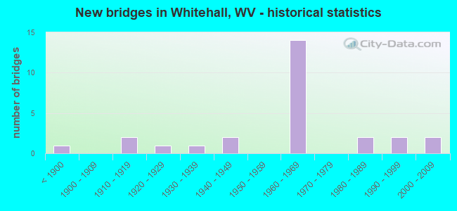
- New bridges - historical statistics
- 1Before 1900
- 21910-1919
- 11920-1929
- 11930-1939
- 21940-1949
- 141960-1969
- 21980-1989
- 21990-1999
- 22000-2009


- Bridge Condition - Deck
- 6.7%Very good
- 46.7%Good
- 20.0%Satisfactory
- 26.7%Fair

- Bridge Condition - Superstructure
- 15.8%Very good
- 31.6%Good
- 21.1%Satisfactory
- 21.1%Fair
- 5.3%Poor
- 5.3%Serious

- Bridge Condition - Substructure
- 38.9%Good
- 33.3%Satisfactory
- 27.8%Fair

- Bridge Condition - Channel
- 6.7%Excellent
- 33.3%Very good
- 46.7%Good
- 13.3%Fair
Find on map >> Show street view
Structure Number: 17A059, Location: 0.03 MI WEST CO RT 73/73 (Lat: 39.392200, Lng: -80.198400), Route carried "on" structure: County highway 1201, Year Built: 1981, Status: Open, Structure Length: 1.98m (6.50ft), Average Daily Traffic: 50 (year 2019), Truck Traffic: 8%, Average Future Daily Traffic: 80 (year 2041), Design Load: HS 25 or greater, Features Intersected: BOOTHS CREEK, Facility Carried by Structure: HARRISON CR 12/1
Minimum Vertical Clearance: 30+ m (98+ ft), Kilometerpoint: 0.016, Lanes on structure: 2, Owner: State Highway Agency, Approaching Roadway Width: 4.9m (16.1ft), Skew: 2 degrees, Material/Design: Steel, Design/Construction: Stringer/Multi-beam, Number Of Spans In Main Unit: 1, Length of Maximum Span: 18.1m (59.4ft), Curb-To-Curb Width: 5.5m (18.0ft), Out-to-Out Width: 5.5m (18.0ft)
Condition: Deck: Good, Superstructure: Satisfactory, Substructure: Good, Channel: Good, Operating Rating: 80.7 metric tons, Method Used To Determine Operating Rating: Load Factor (LF), Inventory Rating: 48.1 metric tons, Method Used To Determine Inventory Rating: Load Factor (LF), Structural Evaluation: Equal to present minimum criteria, Deck Geometry: Meets minimum limits, Waterway Adequacy: Equal to present minimum criteria, Approach Roadway Alignment: Meets minimum limits, Length Of Structure Improvement: 2.68m (8.79ft), Designated Inspection Frequency: Every 24 months, Inspection Date: December 2021, Bridge Improvement Cost: $411,000, Roadway Improvement Cost: $132,000, Total Project Cost: $628,000 ( Estimate for 2022), Deck Structure Type: Concrete Cast-file-Place, Wearing Surface/Protective System: Deck Protection: Galvanized Reinforcing
Find on map >> Show street view
Structure Number: 17A235, Location: 0.05 MI NORTH CO RT 1 (Lat: 39.371511, Lng: -80.203789), Route carried "on" structure: County highway 7373, Year Built: 1928, Status: Open, Structure Length: 1.06m (3.48ft), Average Daily Traffic: 3,200 (year 2018), Truck Traffic: 7%, Average Future Daily Traffic: 4,200 (year 2038), Features Intersected: THOMAS FORK, Facility Carried by Structure: HARR. CO. RT 73/73
Minimum Vertical Clearance: 30+ m (98+ ft), Kilometerpoint: 3.895, Lanes on structure: 2, Owner: State Highway Agency, Approaching Roadway Width: 7.6m (24.9ft), Skew: 5 degrees, Material/Design: Concrete, Design/Construction: Slab, Number Of Spans In Main Unit: 1, Length of Maximum Span: 8.8m (28.9ft), Curb-To-Curb Width: 6.0m (19.7ft), Out-to-Out Width: 6.9m (22.6ft)
Condition: Superstructure: Satisfactory, Substructure: Satisfactory, Channel: Fair, Operating Rating: 63.5 metric tons, Method Used To Determine Operating Rating: Field evaluation and documented engineering judgment, Inventory Rating: 29.0 metric tons, Method Used To Determine Inventory Rating: Field evaluation and documented engineering judgment, Structural Evaluation: Equal to present minimum criteria, Deck Geometry: High priority of replacement, Waterway Adequacy: Equal to present minimum criteria, Approach Roadway Alignment: Equal to present desirable criteria, Length Of Structure Improvement: 0.88m (2.89ft), Designated Inspection Frequency: Every 24 months, Inspection Date: April 2020, Bridge Improvement Cost: $241,000, Roadway Improvement Cost: $192,000, Total Project Cost: $464,000 ( Estimate for 2020), Deck Structure Type: Concrete Cast-file-Place, Wearing Surface/Protective System: Wearing Surface: Bituminous
Find on map >> Show street view
Structure Number: 17A265, Location: 3.15 MI SOUTH US RT 250 (Lat: 39.392911, Lng: -80.206611), Route carried "on" structure: Interstate 7900, Year Built: 1965, Status: Open, Structure Length: 3.83m (12.57ft), Average Daily Traffic: 22,700 (year 2019), Truck Traffic: 13%, Average Future Daily Traffic: 29,050 (year 2041), Design Load: HS 20, Features Intersected: Har Co Rt. 12/1, Facility Carried by Structure: INTERSTATE 79 NB
Minimum Vertical Clearance: 30+ m (98+ ft), Kilometerpoint: 207.477, Lanes on structure: 2, Lanes under structure: 2, Base Highway Network: Yes, Owner: State Highway Agency, Approaching Roadway Width: 11.0m (36.1ft), Material/Design: Steel continuous, Design/Construction: Stringer/Multi-beam, Number Of Spans In Main Unit: 1, Number Of Approach Spans: 2, Length of Maximum Span: 14.5m (47.6ft), Curb-To-Curb Width: 11.2m (36.7ft), Out-to-Out Width: 12.3m (40.4ft)
Condition: Deck: Satisfactory, Superstructure: Fair, Substructure: Satisfactory, Operating Rating: 56.2 metric tons, Method Used To Determine Operating Rating: Load Factor (LF), Inventory Rating: 34.5 metric tons, Method Used To Determine Inventory Rating: Load Factor (LF), Structural Evaluation: Somewhat better than minimum adequacy, Deck Geometry: Somewhat better than minimum adequacy, Underclear: Somewhat better than minimum adequacy, Approach Roadway Alignment: Equal to present desirable criteria, Length Of Structure Improvement: 3.84m (12.60ft), Designated Inspection Frequency: Every 24 months, Other Special Inspection Frequency: Every 12 months, Inspection Date: October 2021, Other Special Inspection Date: October 2021, Bridge Improvement Cost: $654,000, Roadway Improvement Cost: $121,000, Total Project Cost: $917,000 ( Estimate for 2022), Deck Structure Type: Concrete Cast-file-Place, Wearing Surface/Protective System: Wearing Surface: Latex Concrete
Find on map >> Show street view
Structure Number: 17A267, Location: 3.15 MI SOUTH US RT 250 (Lat: 39.392811, Lng: -80.206381), Route carried "on" structure: Interstate 7900, Year Built: 1965, Status: Open, Structure Length: 3.83m (12.57ft), Average Daily Traffic: 22,700 (year 2019), Truck Traffic: 13%, Average Future Daily Traffic: 29,050 (year 2041), Design Load: HS 20, Features Intersected: Harr Co Rt. 12/1, Facility Carried by Structure: INTERSTATE 79 SB
Minimum Vertical Clearance: 30+ m (98+ ft), Kilometerpoint: 207.477, Lanes on structure: 2, Lanes under structure: 2, Base Highway Network: Yes, Owner: State Highway Agency, Approaching Roadway Width: 11.0m (36.1ft), Material/Design: Steel continuous, Design/Construction: Stringer/Multi-beam, Number Of Spans In Main Unit: 1, Number Of Approach Spans: 2, Length of Maximum Span: 14.5m (47.6ft), Curb-To-Curb Width: 11.2m (36.7ft), Out-to-Out Width: 12.3m (40.4ft)
Condition: Deck: Satisfactory, Superstructure: Satisfactory, Substructure: Satisfactory, Operating Rating: 56.2 metric tons, Method Used To Determine Operating Rating: Load Factor (LF), Inventory Rating: 34.5 metric tons, Method Used To Determine Inventory Rating: Load Factor (LF), Structural Evaluation: Equal to present minimum criteria, Deck Geometry: Somewhat better than minimum adequacy, Underclear: Better than present minimum criteria, Approach Roadway Alignment: Equal to present desirable criteria, Length Of Structure Improvement: 3.84m (12.60ft), Designated Inspection Frequency: Every 24 months, Inspection Date: October 2021, Bridge Improvement Cost: $673,000, Roadway Improvement Cost: $117,000, Total Project Cost: $918,000 ( Estimate for 2022), Deck Structure Type: Concrete Cast-file-Place, Wearing Surface/Protective System: Wearing Surface: Latex Concrete
Find on map >> Show street view
Structure Number: 25A082, Location: 0.18 MI WEST CO RT 73/73 (Lat: 39.416111, Lng: -80.206031), Route carried "on" structure: County highway 2706, Year Built: 1992, Status: Open, Structure Length: 2.55m (8.37ft), Average Daily Traffic: 250 (year 2018), Truck Traffic: 9%, Average Future Daily Traffic: 300 (year 2038), Design Load: HS 25 or greater, Features Intersected: BOOTHS CREEK, Facility Carried by Structure: MARION CO RT 27/6
Minimum Vertical Clearance: 30+ m (98+ ft), Kilometerpoint: 3.975, Lanes on structure: 2, Owner: State Highway Agency, Approaching Roadway Width: 4.6m (15.1ft), Skew: 3 degrees, Material/Design: Prestressed concrete, Design/Construction: Box Beam or Girders - Multiple, Number Of Spans In Main Unit: 1, Length of Maximum Span: 25.0m (82.0ft), Curb-To-Curb Width: 6.1m (20.0ft), Out-to-Out Width: 6.5m (21.3ft)
Condition: Deck: Good, Superstructure: Good, Substructure: Good, Channel: Excellent, Operating Rating: 83.4 metric tons, Method Used To Determine Operating Rating: Load Factor (LF), Inventory Rating: 51.7 metric tons, Method Used To Determine Inventory Rating: Load Factor (LF), Structural Evaluation: Better than present minimum criteria, Deck Geometry: Meets minimum limits, Waterway Adequacy: Better than present minimum criteria, Approach Roadway Alignment: Meets minimum limits, Designated Inspection Frequency: Every 48 months, Inspection Date: July 2020, Deck Structure Type: Other, Wearing Surface/Protective System: Wearing Surface: Bituminous, Deck Protection: Epoxy Coated Reinforcing
Find on map >> Show street view
Structure Number: 25A125, Location: 0.01 MI WEST CO RT 73/73 (Lat: 39.399019, Lng: -80.199711), Route carried "on" structure: County highway 7316, Year Built: 1888, Status: Posted for load, Structure Length: 1.59m (5.22ft), Average Daily Traffic: 2 (year 2019), Average Future Daily Traffic: 2 (year 2041), Features Intersected: BOOTHS CREEK, Facility Carried by Structure: MARION CO RT 73/16
Minimum Vertical Clearance: 30+ m (98+ ft), Kilometerpoint: 0.016, Lanes on structure: 1, Owner: State Highway Agency, Approaching Roadway Width: 3.0m (9.8ft), Material/Design: Steel, Design/Construction: Truss - Thru, Number Of Spans In Main Unit: 1, Length of Maximum Span: 15.8m (51.8ft), Curb or Sidewalk Widths: Left: 0.1m (0.3ft), Right: 0.1m (0.3ft), Curb-To-Curb Width: 2.8m (9.2ft), Out-to-Out Width: 3.1m (10.2ft)
Condition: Deck: Good, Superstructure: Serious, Substructure: Fair, Channel: Good, Operating Rating: 6.3 metric tons, Method Used To Determine Operating Rating: Load Factor (LF), Inventory Rating: 3.6 metric tons, Method Used To Determine Inventory Rating: Load Factor (LF), Structural Evaluation: High priority of replacement, Deck Geometry: High priority of replacement, Waterway Adequacy: Equal to present minimum criteria, Approach Roadway Alignment: Meets minimum limits, Bridge Posting: Required (Relationship of Operating Rating to Maximum Legal Load: > 39.9% below), Length Of Structure Improvement: 2.26m (7.41ft), Designated Inspection Frequency: Every 24 months, Critical Feature Inspection Frequency: Every 24 months, Inspection Date: September 2021, Critical Feature Inspection Date: September 2021, Bridge Improvement Cost: $273,000, Roadway Improvement Cost: $174,000, Total Project Cost: $538,000 ( Estimate for 2021), Deck Structure Type: Wood or Timber
Find on map >> Show street view
Structure Number: 25A129, Location: 2.23 MI SOUTH US RT 250 (Lat: 39.405331, Lng: -80.203889), Route carried "on" structure: Interstate 7900, Year Built: 1966, Status: Open, Structure Length: 8.69m (28.51ft), Average Daily Traffic: 23,200 (year 2019), Truck Traffic: 14%, Average Future Daily Traffic: 31,550 (year 2041), Design Load: HS 20, Features Intersected: Mar. Co. Rt. 73/73, Facility Carried by Structure: INTERSTATE 79 NB
Minimum Vertical Clearance: 30+ m (98+ ft), Kilometerpoint: 208.957, Lanes on structure: 2, Lanes under structure: 2, Base Highway Network: Yes, Owner: State Highway Agency, Approaching Roadway Width: 11.6m (38.1ft), Skew: 3 degrees, Material/Design: Steel continuous, Design/Construction: Stringer/Multi-beam, Number Of Spans In Main Unit: 2, Number Of Approach Spans: 2, Length of Maximum Span: 24.4m (80.1ft), Curb-To-Curb Width: 9.1m (29.9ft), Out-to-Out Width: 10.7m (35.1ft)
Condition: Deck: Fair, Superstructure: Good, Substructure: Fair, Channel: Very good, Operating Rating: 59.9 metric tons, Method Used To Determine Operating Rating: Load Factor (LF), Inventory Rating: 36.3 metric tons, Method Used To Determine Inventory Rating: Load Factor (LF), Structural Evaluation: Somewhat better than minimum adequacy, Deck Geometry: Meets minimum limits, Underclear: Superior to present desirable criteria, Waterway Adequacy: Superior to present desirable criteria, Approach Roadway Alignment: Equal to present desirable criteria, Length Of Structure Improvement: 8.69m (28.51ft), Designated Inspection Frequency: Every 24 months, Inspection Date: September 2021, Bridge Improvement Cost: $1,332,000, Roadway Improvement Cost: $129,000, Total Project Cost: $1,781,000 ( Estimate for 2021), Deck Structure Type: Concrete Cast-file-Place, Wearing Surface/Protective System: Wearing Surface: Latex Concrete
Find on map >> Show street view
Structure Number: 25A131, Location: 1.28 MI SOUTH US RT 250 (Lat: 39.417950, Lng: -80.199119), Route carried "on" structure: Interstate 7900, Year Built: 1967, Status: Open, Structure Length: 0.62m (2.03ft), Average Daily Traffic: 50,400 (year 2018), Truck Traffic: 18%, Average Future Daily Traffic: 72,575 (year 2038), Design Load: HS 20, Features Intersected: Mar. Co. 29/1, Facility Carried by Structure: INTERSTATE 79
Minimum Vertical Clearance: 30+ m (98+ ft), Kilometerpoint: 210.534, Lanes on structure: 4, Lanes under structure: 2, Base Highway Network: Yes, Owner: State Highway Agency, Approaching Roadway Width: 23.2m (76.1ft), Material/Design: Concrete, Design/Construction: Culvert, Number Of Spans In Main Unit: 1, Length of Maximum Span: 6.2m (20.3ft)
Condition: Culverts: Good, Operating Rating: 71.7 metric tons, Method Used To Determine Operating Rating: Field evaluation and documented engineering judgment, Inventory Rating: 32.7 metric tons, Method Used To Determine Inventory Rating: Field evaluation and documented engineering judgment, Structural Evaluation: Better than present minimum criteria, Underclear: High priority of replacement, Approach Roadway Alignment: Equal to present desirable criteria, Length Of Structure Improvement: 1.10m (3.61ft), Designated Inspection Frequency: Every 24 months, Inspection Date: November 2020, Bridge Improvement Cost: $722,000, Roadway Improvement Cost: $683,000, Total Project Cost: $1,677,000 ( Estimate for 2020)
Find on map >> Show street view
Structure Number: 25A132, Location: 1.3 MI SOUTH CO RT 64/1 (Lat: 39.432200, Lng: -80.187300), Route carried "on" structure: Interstate 7900, Year Built: 1962, Status: Open, Structure Length: 7.07m (23.20ft), Average Daily Traffic: 24,750 (year 2019), Truck Traffic: 14%, Average Future Daily Traffic: 33,660 (year 2041), Design Load: HS 20, Features Intersected: US 250, Facility Carried by Structure: INTERSTATE 79 NB
Minimum Vertical Clearance: 30+ m (98+ ft), Kilometerpoint: 212.546, Lanes on structure: 2, Lanes under structure: 4, Base Highway Network: Yes, Owner: State Highway Agency, Approaching Roadway Width: 12.2m (40.0ft), Skew: 4 degrees, Material/Design: Steel continuous, Design/Construction: Stringer/Multi-beam, Number Of Spans In Main Unit: 1, Number Of Approach Spans: 2, Length of Maximum Span: 28.3m (92.8ft), Curb-To-Curb Width: 9.1m (29.9ft), Out-to-Out Width: 10.7m (35.1ft)
Condition: Deck: Fair, Superstructure: Good, Substructure: Satisfactory, Operating Rating: 61.7 metric tons, Method Used To Determine Operating Rating: Load Factor (LF), Inventory Rating: 37.2 metric tons, Method Used To Determine Inventory Rating: Load Factor (LF), Structural Evaluation: Equal to present minimum criteria, Deck Geometry: Meets minimum limits, Underclear: High priority of replacement, Approach Roadway Alignment: Better than present minimum criteria, Length Of Structure Improvement: 8.14m (26.71ft), Designated Inspection Frequency: Every 24 months, Inspection Date: December 2021, Bridge Improvement Cost: $827,000, Roadway Improvement Cost: $731,000, Total Project Cost: $1,872,000 ( Estimate for 2022), Deck Structure Type: Concrete Cast-file-Place, Wearing Surface/Protective System: Wearing Surface: Bituminous
Find on map >> Show street view
Structure Number: 25A133, Location: 1.3 MI SOUTH CO RT 64/1 (Lat: 39.432500, Lng: -80.187100), Route carried "on" structure: Interstate 7900, Year Built: 1962, Status: Open, Structure Length: 7.07m (23.20ft), Average Daily Traffic: 24,750 (year 2019), Truck Traffic: 14%, Average Future Daily Traffic: 33,660 (year 2041), Design Load: HS 20, Features Intersected: US 250, Facility Carried by Structure: INTERSTATE 79 SB
Minimum Vertical Clearance: 30+ m (98+ ft), Kilometerpoint: 212.546, Lanes on structure: 2, Lanes under structure: 4, Base Highway Network: Yes, Owner: State Highway Agency, Approaching Roadway Width: 12.2m (40.0ft), Skew: 4 degrees, Material/Design: Steel continuous, Design/Construction: Stringer/Multi-beam, Number Of Spans In Main Unit: 1, Number Of Approach Spans: 2, Length of Maximum Span: 28.3m (92.8ft), Curb-To-Curb Width: 9.1m (29.9ft), Out-to-Out Width: 10.7m (35.1ft)
Condition: Deck: Fair, Superstructure: Good, Substructure: Fair, Operating Rating: 61.7 metric tons, Method Used To Determine Operating Rating: Load Factor (LF), Inventory Rating: 37.2 metric tons, Method Used To Determine Inventory Rating: Load Factor (LF), Structural Evaluation: Somewhat better than minimum adequacy, Deck Geometry: Meets minimum limits, Underclear: High priority of replacement, Approach Roadway Alignment: Better than present minimum criteria, Length Of Structure Improvement: 8.14m (26.71ft), Designated Inspection Frequency: Every 24 months, Inspection Date: December 2021, Bridge Improvement Cost: $827,000, Roadway Improvement Cost: $731,000, Total Project Cost: $1,872,000 ( Estimate for 2022), Deck Structure Type: Concrete Cast-file-Place, Wearing Surface/Protective System: Wearing Surface: Bituminous
Find on map >> Show street view
Structure Number: 25A231, Location: 2.23 MI SOUTH US RT 250 (Lat: 39.405200, Lng: -80.203950), Route carried "on" structure: Interstate 7900, Year Built: 1966, Year Reconstructed: 1998, Status: Open, Structure Length: 8.69m (28.51ft), Average Daily Traffic: 22,800 (year 2018), Truck Traffic: 18%, Average Future Daily Traffic: 32,825 (year 2038), Design Load: HS 25 or greater, Features Intersected: Booths Creek & Mar 73/73, Facility Carried by Structure: INTERSTATE 79 SB
Minimum Vertical Clearance: 30+ m (98+ ft), Kilometerpoint: 208.957, Lanes on structure: 2, Lanes under structure: 2, Base Highway Network: Yes, Owner: State Highway Agency, Approaching Roadway Width: 11.6m (38.1ft), Skew: 3 degrees, Material/Design: Steel continuous, Design/Construction: Stringer/Multi-beam, Number Of Spans In Main Unit: 2, Number Of Approach Spans: 2, Length of Maximum Span: 24.4m (80.1ft), Curb-To-Curb Width: 9.8m (32.2ft), Out-to-Out Width: 10.9m (35.8ft)
Condition: Deck: Satisfactory, Superstructure: Satisfactory, Substructure: Satisfactory, Channel: Good, Operating Rating: 85.3 metric tons, Method Used To Determine Operating Rating: Load Factor (LF), Inventory Rating: 50.8 metric tons, Method Used To Determine Inventory Rating: Load Factor (LF), Structural Evaluation: Equal to present minimum criteria, Deck Geometry: Meets minimum limits, Underclear: Superior to present desirable criteria, Waterway Adequacy: Superior to present desirable criteria, Approach Roadway Alignment: Better than present minimum criteria, Designated Inspection Frequency: Every 24 months, Inspection Date: August 2020, Deck Structure Type: Concrete Cast-file-Place, Wearing Surface/Protective System: Wearing Surface: Monolithic Concrete
Find on map >> Show street view
Structure Number: 25A232, Location: 0.02 MI SOUTH MAR 29/2 (Lat: 39.414719, Lng: -80.203381), Route carried "on" structure: County highway 7373, Year Built: 1999, Status: Open, Structure Length: 2.22m (7.28ft), Average Daily Traffic: 3,200 (year 2018), Truck Traffic: 9%, Average Future Daily Traffic: 3,925 (year 2038), Design Load: HS 25 or greater, Features Intersected: BOOTHS CREEK, Facility Carried by Structure: MARION CO RT 73/73
Minimum Vertical Clearance: 30+ m (98+ ft), Kilometerpoint: 3.090, Lanes on structure: 2, Owner: State Highway Agency, Approaching Roadway Width: 7.9m (25.9ft), Skew: 2 degrees, Material/Design: Steel, Design/Construction: Stringer/Multi-beam, Number Of Spans In Main Unit: 1, Length of Maximum Span: 21.3m (69.9ft), Curb-To-Curb Width: 8.5m (27.9ft), Out-to-Out Width: 8.7m (28.5ft)
Condition: Deck: Good, Superstructure: Very good, Substructure: Good, Channel: Very good, Operating Rating: 65.3 metric tons, Method Used To Determine Operating Rating: Load Factor (LF), Inventory Rating: 39.0 metric tons, Method Used To Determine Inventory Rating: Load Factor (LF), Structural Evaluation: Better than present minimum criteria, Deck Geometry: Meets minimum limits, Waterway Adequacy: Superior to present desirable criteria, Approach Roadway Alignment: Equal to present minimum criteria, Length Of Structure Improvement: 2.44m (8.01ft), Designated Inspection Frequency: Every 48 months, Inspection Date: July 2019, Bridge Improvement Cost: $632,000, Roadway Improvement Cost: $105,000, Total Project Cost: $794,000 ( Estimate for 2019), Deck Structure Type: Concrete Cast-file-Place, Wearing Surface/Protective System: Deck Protection: Galvanized Reinforcing
Find on map >> Show street view
Structure Number: 25A251, Location: 0.06 MI SOUTH MRN CO 29/5 (Lat: 39.409361, Lng: -80.206239), Route carried "on" structure: County highway 7373, Year Built: 2003, Status: Open, Structure Length: 3.84m (12.60ft), Average Daily Traffic: 3,200 (year 2019), Truck Traffic: 8%, Average Future Daily Traffic: 4,990 (year 2041), Design Load: HS 25 or greater, Features Intersected: BOOTHS CREEK, Facility Carried by Structure: MARION CO RT 73/73
Minimum Vertical Clearance: 30+ m (98+ ft), Kilometerpoint: 2.414, Lanes on structure: 2, Owner: State Highway Agency, Approaching Roadway Width: 8.2m (26.9ft), Skew: 4 degrees, Material/Design: Steel, Design/Construction: Stringer/Multi-beam, Number Of Spans In Main Unit: 2, Length of Maximum Span: 18.1m (59.4ft), Curb-To-Curb Width: 8.5m (27.9ft), Out-to-Out Width: 8.7m (28.5ft)
Condition: Deck: Very good, Superstructure: Very good, Substructure: Satisfactory, Channel: Very good, Operating Rating: 78.0 metric tons, Method Used To Determine Operating Rating: Load Factor (LF), Inventory Rating: 47.2 metric tons, Method Used To Determine Inventory Rating: Load Factor (LF), Structural Evaluation: Equal to present minimum criteria, Deck Geometry: Meets minimum limits, Waterway Adequacy: Superior to present desirable criteria, Approach Roadway Alignment: Better than present minimum criteria, Designated Inspection Frequency: Every 48 months, Inspection Date: September 2021, Deck Structure Type: Closed Grating, Wearing Surface/Protective System: Deck Protection: Galvanized Reinforcing
Find on map >> Show street view
Structure Number: 46A001, Location: 0.02 MI EAST CO RT 1 (Lat: 39.369881, Lng: -80.200711), Route carried "on" structure: County highway 101, Year Built: 1919, Status: Open, Structure Length: 0.91m (2.99ft), Average Daily Traffic: 100 (year 2017), Average Future Daily Traffic: 120 (year 2039), Features Intersected: CORBIN BRANCH, Facility Carried by Structure: TAYLOR CO RT 1/1
Minimum Vertical Clearance: 30+ m (98+ ft), Kilometerpoint: 0.032, Lanes on structure: 1, Owner: State Highway Agency, Approaching Roadway Width: 3.7m (12.1ft), Material/Design: Concrete, Design/Construction: Arch - Deck, Number Of Spans In Main Unit: 1, Length of Maximum Span: 9.1m (29.9ft), Curb-To-Curb Width: 4.3m (14.1ft), Out-to-Out Width: 4.8m (15.7ft)
Condition: Superstructure: Fair, Substructure: Fair, Channel: Fair, Operating Rating: 47.2 metric tons, Method Used To Determine Operating Rating: Field evaluation and documented engineering judgment, Inventory Rating: 21.8 metric tons, Method Used To Determine Inventory Rating: Field evaluation and documented engineering judgment, Structural Evaluation: Somewhat better than minimum adequacy, Deck Geometry: Equal to present minimum criteria, Waterway Adequacy: Equal to present minimum criteria, Approach Roadway Alignment: Equal to present desirable criteria, Length Of Structure Improvement: 1.65m (5.41ft), Designated Inspection Frequency: Every 24 months, Inspection Date: Febuary 2021, Bridge Improvement Cost: $238,000, Roadway Improvement Cost: $154,000, Total Project Cost: $471,000 ( Estimate for 2021)
Find on map >> Show street view
Structure Number: 46A004, Location: 0.03 MI WEST CO RT 250/6 (Lat: 39.374600, Lng: -80.159700), Route carried "on" structure: County highway 200, Year Built: 1911, Status: Open, Structure Length: 0.98m (3.22ft), Average Daily Traffic: 100 (year 2019), Average Future Daily Traffic: 180 (year 2041), Features Intersected: HUSTEAD FORK, Facility Carried by Structure: TAYLOR CO RT 2
Minimum Vertical Clearance: 30+ m (98+ ft), Kilometerpoint: 1.609, Lanes on structure: 2, Owner: State Highway Agency, Approaching Roadway Width: 4.9m (16.1ft), Material/Design: Concrete, Design/Construction: Arch - Deck, Number Of Spans In Main Unit: 1, Length of Maximum Span: 9.8m (32.2ft), Curb or Sidewalk Widths: Left: 0.1m (0.3ft), Right: 0.1m (0.3ft), Curb-To-Curb Width: 6.5m (21.3ft), Out-to-Out Width: 6.7m (22.0ft)
Condition: Superstructure: Good, Substructure: Good, Channel: Very good, Operating Rating: 47.2 metric tons, Method Used To Determine Operating Rating: Field evaluation and documented engineering judgment, Inventory Rating: 21.8 metric tons, Method Used To Determine Inventory Rating: Field evaluation and documented engineering judgment, Structural Evaluation: Equal to present minimum criteria, Deck Geometry: Somewhat better than minimum adequacy, Waterway Adequacy: Equal to present desirable criteria, Approach Roadway Alignment: High priority of replacement, Length Of Structure Improvement: 1.74m (5.71ft), Designated Inspection Frequency: Every 24 months, Inspection Date: October 2021, Bridge Improvement Cost: $308,000, Roadway Improvement Cost: $175,000, Total Project Cost: $608,000 ( Estimate for 2022)
Find on map >> Show street view
Structure Number: 46A007, Location: 0.03 MI SOUTH CO RT 3/7 (Lat: 39.357700, Lng: -80.159339), Route carried "on" structure: County highway 305, Year Built: 1940, Status: Posted for load, Structure Length: 0.69m (2.26ft), Average Daily Traffic: 200 (year 2020), Truck Traffic: 6%, Average Future Daily Traffic: 225 (year 2040), Features Intersected: HUSTEAD FORK, Facility Carried by Structure: TAYLOR CO RTE 3/5
Minimum Vertical Clearance: 30+ m (98+ ft), Kilometerpoint: 1.239, Lanes on structure: 1, Owner: State Highway Agency, Approaching Roadway Width: 5.5m (18.0ft), Skew: 1 degrees, Material/Design: Steel, Design/Construction: Girder and Floorbeam System, Number Of Spans In Main Unit: 1, Length of Maximum Span: 6.6m (21.7ft), Curb-To-Curb Width: 4.1m (13.5ft), Out-to-Out Width: 4.2m (13.8ft)
Condition: Deck: Good, Superstructure: Poor, Substructure: Fair, Channel: Good, Operating Rating: 41.7 metric tons, Method Used To Determine Operating Rating: Load Factor (LF), Inventory Rating: 30.8 metric tons, Method Used To Determine Inventory Rating: Load Factor (LF), Structural Evaluation: Meets minimum limits, Deck Geometry: High priority of replacement, Waterway Adequacy: Better than present minimum criteria, Approach Roadway Alignment: Somewhat better than minimum adequacy, Length Of Structure Improvement: 1.31m (4.30ft), Designated Inspection Frequency: Every 24 months, Inspection Date: March 2020, Bridge Improvement Cost: $172,000, Roadway Improvement Cost: $129,000, Total Project Cost: $451,000 ( Estimate for 2020), Deck Structure Type: Wood or Timber, Wearing Surface/Protective System: Wearing Surface: Bituminous
Find on map >> Show street view
Structure Number: 46A008, Location: 0.05 MI SOUTH CO RT 250/6 (Lat: 39.369150, Lng: -80.157219), Route carried "on" structure: County highway 307, Year Built: 1943, Status: Open, Structure Length: 0.79m (2.59ft), Average Daily Traffic: 100 (year 2018), Average Future Daily Traffic: 120 (year 2038), Features Intersected: PLUMMER RUN, Facility Carried by Structure: TAYLOR CO. RT 3/7
Minimum Vertical Clearance: 30+ m (98+ ft), Kilometerpoint: 5.472, Lanes on structure: 1, Owner: State Highway Agency, Approaching Roadway Width: 4.9m (16.1ft), Skew: 2 degrees, Material/Design: Steel, Design/Construction: Stringer/Multi-beam, Number Of Spans In Main Unit: 1, Length of Maximum Span: 7.8m (25.6ft), Curb-To-Curb Width: 4.5m (14.8ft), Out-to-Out Width: 5.3m (17.4ft)
Condition: Deck: Fair, Superstructure: Fair, Substructure: Good, Channel: Good, Operating Rating: 82.5 metric tons, Method Used To Determine Operating Rating: Load Factor (LF), Inventory Rating: 49.0 metric tons, Method Used To Determine Inventory Rating: Load Factor (LF), Structural Evaluation: Somewhat better than minimum adequacy, Deck Geometry: Equal to present minimum criteria, Waterway Adequacy: Equal to present minimum criteria, Approach Roadway Alignment: Somewhat better than minimum adequacy, Length Of Structure Improvement: 1.37m (4.49ft), Designated Inspection Frequency: Every 24 months, Inspection Date: March 2020, Bridge Improvement Cost: $168,000, Roadway Improvement Cost: $131,000, Total Project Cost: $454,000 ( Estimate for 2020), Deck Structure Type: Concrete Cast-file-Place, Wearing Surface/Protective System: Wearing Surface: Bituminous
Find on map >> Show street view
Structure Number: 46A01, Location: 0.17 MI SOUTH CO RT 73/12 (Lat: 39.393331, Lng: -80.193600), Route carried "on" structure: County highway 316, Year Built: 1980, Status: Open, Structure Length: 1.85m (6.07ft), Average Daily Traffic: 100 (year 2018), Average Future Daily Traffic: 125 (year 2038), Design Load: HS 20, Features Intersected: HUSTEAD FORK, Facility Carried by Structure: TAYLOR CO RT 3/16
Minimum Vertical Clearance: 30+ m (98+ ft), Kilometerpoint: 0.193, Lanes on structure: 1, Owner: State Highway Agency, Approaching Roadway Width: 4.3m (14.1ft), Material/Design: Steel, Design/Construction: Stringer/Multi-beam, Number Of Spans In Main Unit: 1, Length of Maximum Span: 17.4m (57.1ft), Curb-To-Curb Width: 4.3m (14.1ft), Out-to-Out Width: 5.2m (17.1ft)
Condition: Deck: Good, Superstructure: Good, Substructure: Good, Channel: Good, Operating Rating: 87.1 metric tons, Method Used To Determine Operating Rating: Load Factor (LF), Inventory Rating: 52.6 metric tons, Method Used To Determine Inventory Rating: Load Factor (LF), Structural Evaluation: Better than present minimum criteria, Deck Geometry: Equal to present minimum criteria, Waterway Adequacy: Better than present minimum criteria, Approach Roadway Alignment: Better than present minimum criteria, Designated Inspection Frequency: Every 24 months, Inspection Date: September 2020, Deck Structure Type: Concrete Cast-file-Place, Wearing Surface/Protective System: Deck Protection: Epoxy Coated Reinforcing
Find on map >> Show street view
Structure Number: 46A041, Location: 0.48 MI NORTH CO RT 1 (Lat: 39.376439, Lng: -80.200000), Route carried "on" structure: County highway 7373, Year Built: 1937, Status: Open, Structure Length: 1.30m (4.27ft), Average Daily Traffic: 1,600 (year 2019), Truck Traffic: 6%, Average Future Daily Traffic: 1,875 (year 2039), Features Intersected: BOOTHS CREEK, Facility Carried by Structure: TAYLOR CO RT 73/73
Minimum Vertical Clearance: 30+ m (98+ ft), Kilometerpoint: 0.016, Lanes on structure: 2, Owner: State Highway Agency, Approaching Roadway Width: 6.7m (22.0ft), Material/Design: Concrete, Design/Construction: Arch - Deck, Number Of Spans In Main Unit: 1, Length of Maximum Span: 13.0m (42.7ft), Curb-To-Curb Width: 8.0m (26.2ft), Out-to-Out Width: 8.9m (29.2ft)
Condition: Superstructure: Fair, Channel: Good, Operating Rating: 55.3 metric tons, Method Used To Determine Operating Rating: Field evaluation and documented engineering judgment, Inventory Rating: 23.6 metric tons, Method Used To Determine Inventory Rating: Field evaluation and documented engineering judgment, Structural Evaluation: Somewhat better than minimum adequacy, Deck Geometry: Meets minimum limits, Waterway Adequacy: Equal to present desirable criteria, Approach Roadway Alignment: Better than present minimum criteria, Designated Inspection Frequency: Every 24 months, Inspection Date: January 2021
Find on map >> Show street view
Structure Number: 46A087, Location: 0.03 MI SOUTH CO RT 73/7 (Lat: 39.393011, Lng: -80.197011), Route carried "on" structure: County highway 7373, Year Built: 2006, Status: Open, Structure Length: 3.30m (10.83ft), Average Daily Traffic: 1,600 (year 2019), Truck Traffic: 6%, Average Future Daily Traffic: 1,875 (year 2039), Design Load: HL 93, Features Intersected: HUSTEAD FORK, Facility Carried by Structure: TAYLOR CO 73/73
Minimum Vertical Clearance: 30+ m (98+ ft), Kilometerpoint: 2.124, Lanes on structure: 2, Owner: State Highway Agency, Approaching Roadway Width: 9.8m (32.2ft), Skew: 2 degrees, Material/Design: Steel, Design/Construction: Stringer/Multi-beam, Number Of Spans In Main Unit: 1, Length of Maximum Span: 32.0m (105.0ft), Curb-To-Curb Width: 10.1m (33.1ft), Out-to-Out Width: 10.8m (35.4ft)
Condition: Deck: Good, Superstructure: Very good, Substructure: Good, Channel: Very good, Operating Rating: 59.9 metric tons, Method Used To Determine Operating Rating: Load and Resistance Factor (LRFR), Inventory Rating: 46.3 metric tons, Method Used To Determine Inventory Rating: Load and Resistance Factor (LRFR), Structural Evaluation: Better than present minimum criteria, Deck Geometry: Somewhat better than minimum adequacy, Waterway Adequacy: Equal to present desirable criteria, Approach Roadway Alignment: Equal to present desirable criteria, Designated Inspection Frequency: Every 24 months, Inspection Date: January 2021, Deck Structure Type: Concrete Cast-file-Place, Wearing Surface/Protective System: Deck Protection: Epoxy Coated Reinforcing
Find on map >> Show street view
Structure Number: 17A265, Location: 3.15 MI SOUTH US RT 250 (Lat: 39.392911, Lng: -80.206611), Route carried "under" structure: County highway 1201, Year Built: 1965, Structure Length: 0. m, Average Daily Traffic: 50 (year 0018), Features Intersected: Har Co Rt. 12/1, Facility Carried by Structure: INTERSTATE 79 NB
Minimum Vertical Clearance: 4.75m (15.58ft), Kilometerpoint: 0.724, Lanes on structure: 2, Lanes under structure: 2, Length of Maximum Span: 14.5m (47.6ft)
Find on map >> Show street view
Structure Number: 17A267, Location: 3.15 MI SOUTH US RT 250 (Lat: 39.392881, Lng: -80.206619), Route carried "under" structure: County highway 1201, Year Built: 1965, Structure Length: 0. m, Average Daily Traffic: 50 (year 0018), Features Intersected: Harr Co Rt. 12/1, Facility Carried by Structure: INTERSTATE 79 SB
Minimum Vertical Clearance: 5.26m (17.26ft), Kilometerpoint: 0.724, Lanes on structure: 2, Lanes under structure: 2, Length of Maximum Span: 14.5m (47.6ft)
Find on map >> Show street view
Structure Number: 25A129, Location: 2.23 MI SOUTH US RT 250 (Lat: 39.405331, Lng: -80.203889), Route carried "under" structure: County highway 7373, Year Built: 1966, Structure Length: 0. m, Average Daily Traffic: 3,200 (year 0018), Truck Traffic: 9%, Features Intersected: Mar. Co. Rt. 73/73, Facility Carried by Structure: INTERSTATE 79 NB
Minimum Vertical Clearance: 11.38m (37.34ft), Kilometerpoint: 1.851, Lanes on structure: 2, Lanes under structure: 2, Length of Maximum Span: 24.4m (80.1ft)
Find on map >> Show street view
Structure Number: 25A131, Location: 1.28 MI SOUTH US RT 250 (Lat: 39.417931, Lng: -80.199169), Route carried "under" structure: County highway 2901, Year Built: 1967, Structure Length: 0. m, Average Daily Traffic: 50 (year 0018), Features Intersected: Mar. Co. 29/1, Facility Carried by Structure: INTERSTATE 79
Minimum Vertical Clearance: 4.12m (13.52ft), Kilometerpoint: 0.628, Lanes on structure: 4, Lanes under structure: 2, Length of Maximum Span: 6.2m (20.3ft)
Find on map >> Show street view
Structure Number: 25A132, Location: 1.3 MI SOUTH CO RT 64/1 (Lat: 39.432289, Lng: -80.187181), Route carried "under" structure: US 25000, Year Built: 1962, Structure Length: 0. m, Average Daily Traffic: 30,400 (year 0018), Truck Traffic: 5%, Features Intersected: US 250, Facility Carried by Structure: INTERSTATE 79 NB
Minimum Vertical Clearance: 5.87m (19.26ft), Kilometerpoint: 5.021, Lanes on structure: 2, Lanes under structure: 4, Length of Maximum Span: 28.3m (92.8ft)
Find on map >> Show street view
Structure Number: 25A133, Location: 1.3 MI SOUTH CO RT 64/1 (Lat: 39.432461, Lng: -80.187119), Route carried "under" structure: US 25000, Year Built: 1962, Structure Length: 0. m, Average Daily Traffic: 30,400 (year 0018), Truck Traffic: 5%, Features Intersected: US 250, Facility Carried by Structure: INTERSTATE 79 SB
Minimum Vertical Clearance: 6.96m (22.83ft), Kilometerpoint: 5.069, Lanes on structure: 2, Lanes under structure: 4, Length of Maximum Span: 28.3m (92.8ft)
Find on map >> Show street view
Structure Number: 25A231, Location: 2.23 MI SOUTH US RT 250 (Lat: 39.405200, Lng: -80.203950), Route carried "under" structure: County highway 7373, Year Built: 1966, Structure Length: 0. m, Average Daily Traffic: 3,200 (year 0018), Truck Traffic: 9%, Features Intersected: Booths Creek & Mar 73/73, Facility Carried by Structure: INTERSTATE 79 SB
Minimum Vertical Clearance: 11.38m (37.34ft), Kilometerpoint: 1.851, Lanes on structure: 2, Lanes under structure: 2, Length of Maximum Span: 24.4m (80.1ft)