Bridge Statistics for Whitsett, North Carolina (NC)
Condition, Traffic, Stress, Structural Evaluation, Project Costs
- National Bridge Inventory (NBI) Statistics
- 11Number of bridges
- 75ft / 23.3mTotal length
- 376,290Total average daily traffic
- 66,028Total average daily truck traffic
- National Bridge Inventory (NBI) Registered Bridges for Whitsett
- No street view available for this location
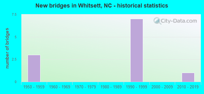
- New bridges - historical statistics
- 31950-1959
- 71990-1999
- 12010-2019


- Bridge Condition - Deck
- 40.0%Very good
- 60.0%Good

- Bridge Condition - Superstructure
- 40.0%Very good
- 40.0%Good
- 20.0%Poor

- Bridge Condition - Substructure
- 40.0%Very good
- 40.0%Good
- 20.0%Poor

- Bridge Condition - Channel
- 80.0%Good
- 20.0%Fair

- Bridge Condition - Culverts
- 50.0%Satisfactory
- 50.0%Fair
Find on map >> Show street view
Structure Number: 81015, Location: 1.1 MI. S. JCT. US70 (Lat: 36.061989, Lng: -79.566050), Route carried "on" structure: State highway 61, Year Built: 1992, Status: Open, Structure Length: 7.07m (23.20ft), Average Daily Traffic: 7,800 (year 2017), Truck Traffic: 7%, Average Future Daily Traffic: 15,600 (year 2040), Design Load: HS 20+Mod, Features Intersected: I40 & I85
Minimum Vertical Clearance: 30+ m (98+ ft), Kilometerpoint: 0.000, Lanes on structure: 2, Lanes under structure: 8, Owner: State Highway Agency, Approaching Roadway Width: 13.7m (44.9ft), Skew: 2 degrees, Material/Design: Prestressed concrete, Design/Construction: Stringer/Multi-beam, Number Of Spans In Main Unit: 4, Length of Maximum Span: 24.6m (80.7ft), Curb-To-Curb Width: 14.6m (47.9ft), Out-to-Out Width: 15.5m (50.9ft)
Condition: Deck: Good, Superstructure: Good, Substructure: Good, Operating Rating: 74.3 metric tons, Method Used To Determine Operating Rating: Load Factor (LF), Inventory Rating: 36.2 metric tons, Method Used To Determine Inventory Rating: Load Factor (LF), Structural Evaluation: Better than present minimum criteria, Deck Geometry: Superior to present desirable criteria, Underclear: Meets minimum limits, Approach Roadway Alignment: Equal to present desirable criteria, Designated Inspection Frequency: Every 24 months, Inspection Date: July 2020, Deck Structure Type: Concrete Cast-file-Place, Wearing Surface/Protective System: Wearing Surface: Monolithic Concrete, Deck Protection: Epoxy Coated Reinforcing
Find on map >> Show street view
Structure Number: 810203, Location: 0.5 MI. E. JCT. SR2800 (Lat: 36.111256, Lng: -79.602331), Route carried "on" structure: State highway 2755, Year Built: 2012, Status: Open, Structure Length: 1.58m (5.18ft), Average Daily Traffic: 990 (year 2017), Truck Traffic: 6%, Average Future Daily Traffic: 1,980 (year 2040), Design Load: HL 93, Features Intersected: ROCK CREEK
Minimum Vertical Clearance: 30+ m (98+ ft), Kilometerpoint: 0.000, Lanes on structure: 2, Owner: State Highway Agency, Approaching Roadway Width: 8.2m (26.9ft), Skew: 3 degrees, Material/Design: Prestressed concrete, Design/Construction: Slab, Number Of Spans In Main Unit: 1, Length of Maximum Span: 14.6m (47.9ft), Curb-To-Curb Width: 9.2m (30.2ft), Out-to-Out Width: 10.0m (32.8ft)
Condition: Deck: Very good, Superstructure: Very good, Substructure: Very good, Channel: Good, Operating Rating: 66.2 metric tons, Method Used To Determine Operating Rating: Load and Resistance Factor (LRFR), Inventory Rating: 51.7 metric tons, Method Used To Determine Inventory Rating: Load and Resistance Factor (LRFR), Structural Evaluation: Equal to present desirable criteria, Deck Geometry: Equal to present minimum criteria, Waterway Adequacy: Better than present minimum criteria, Approach Roadway Alignment: Equal to present desirable criteria, Designated Inspection Frequency: Every 24 months, Inspection Date: April 2020, Deck Structure Type: Concrete Precast Panels, Wearing Surface/Protective System: Wearing Surface: Bituminous
Find on map >> Show street view
Structure Number: 810205, Location: 0.6 MI. E. JCT. SR2808 (Lat: 36.094222, Lng: -79.598522), Route carried "on" structure: State highway 2752, Year Built: 1955, Year Reconstructed: 1988, Status: Posted for load, Structure Length: 1.24m (4.07ft), Average Daily Traffic: 1,300 (year 2017), Truck Traffic: 7%, Average Future Daily Traffic: 2,600 (year 2040), Features Intersected: ROCK CREEK
Minimum Vertical Clearance: 30+ m (98+ ft), Kilometerpoint: 0.000, Lanes on structure: 2, Owner: State Highway Agency, Approaching Roadway Width: 5.7m (18.7ft), Material/Design: Steel continuous, Design/Construction: Stringer/Multi-beam, Number Of Spans In Main Unit: 2, Length of Maximum Span: 6.0m (19.7ft), Curb-To-Curb Width: 6.9m (22.6ft), Out-to-Out Width: 7.3m (24.0ft)
Condition: Deck: Good, Superstructure: Poor, Substructure: Poor, Channel: Good, Operating Rating: 26.3 metric tons, Method Used To Determine Operating Rating: Load Factor (LF), Inventory Rating: 18.1 metric tons, Method Used To Determine Inventory Rating: Load Factor (LF), Structural Evaluation: Meets minimum limits, Deck Geometry: High priority of corrective action, Waterway Adequacy: Better than present minimum criteria, Approach Roadway Alignment: Equal to present desirable criteria, Bridge Posting: Required (Relationship of Operating Rating to Maximum Legal Load: 20.0 - 29.9% below), Designated Inspection Frequency: Every 24 months, Inspection Date: April 2020, Deck Structure Type: Wood or Timber, Wearing Surface/Protective System: Wearing Surface: Bituminous
Find on map >> Show street view
Structure Number: 810209, Location: 150 FT.S. JCT. SR3176 (Lat: 36.051278, Lng: -79.647047), Route carried "on" structure: State highway 3045, Year Built: 1990, Status: Open, Structure Length: 3.44m (11.29ft), Average Daily Traffic: 2,500 (year 2018), Truck Traffic: 6%, Average Future Daily Traffic: 5,000 (year 2040), Design Load: HS 20+Mod, Features Intersected: LITTLE ALAMANCE CREEK
Minimum Vertical Clearance: 30+ m (98+ ft), Kilometerpoint: 0.000, Lanes on structure: 2, Owner: State Highway Agency, Approaching Roadway Width: 9.4m (30.8ft), Material/Design: Prestressed concrete, Design/Construction: Slab, Number Of Spans In Main Unit: 3, Number Of Approach Spans: 2, Length of Maximum Span: 10.9m (35.8ft), Curb-To-Curb Width: 9.1m (29.9ft), Out-to-Out Width: 10.0m (32.8ft)
Condition: Deck: Very good, Superstructure: Very good, Substructure: Very good, Channel: Good, Operating Rating: 81.6 metric tons, Method Used To Determine Operating Rating: Load Factor (LF), Inventory Rating: 48.9 metric tons, Method Used To Determine Inventory Rating: Load Factor (LF), Structural Evaluation: Equal to present desirable criteria, Deck Geometry: Meets minimum limits, Waterway Adequacy: Better than present minimum criteria, Approach Roadway Alignment: Equal to present desirable criteria, Designated Inspection Frequency: Every 24 months, Inspection Date: July 2020, Deck Structure Type: Concrete Precast Panels, Wearing Surface/Protective System: Wearing Surface: Bituminous, Deck Protection: Epoxy Coated Reinforcing
Find on map >> Show street view
Structure Number: 810216, Location: 0.2 MI. W. JCT. SR2748 (Lat: 36.079192, Lng: -79.546767), Route carried "on" structure: US 70, Year Built: 1955, Status: Open, Structure Length: 1.21m (3.97ft), Average Daily Traffic: 11,000 (year 2019), Truck Traffic: 12%, Average Future Daily Traffic: 22,000 (year 2040), Features Intersected: BACK CREEK
Minimum Vertical Clearance: 30+ m (98+ ft), Kilometerpoint: 0.000, Lanes on structure: 2, Base Highway Network: Yes (Inventory Route: 2, Subroute: 70), Owner: State Highway Agency, Approaching Roadway Width: 7.6m (24.9ft), Skew: 5 degrees, Material/Design: Concrete continuous, Design/Construction: Culvert, Number Of Spans In Main Unit: 3, Length of Maximum Span: 2.4m (7.9ft)
Condition: Channel: Good, Culverts: Satisfactory, Operating Rating: 41.7 metric tons, Method Used To Determine Operating Rating: Field evaluation and documented engineering judgment, Inventory Rating: 32.6 metric tons, Method Used To Determine Inventory Rating: Field evaluation and documented engineering judgment, Structural Evaluation: Equal to present minimum criteria, Waterway Adequacy: Better than present minimum criteria, Approach Roadway Alignment: Equal to present desirable criteria, Designated Inspection Frequency: Every 24 months, Inspection Date: Febuary 2022
Find on map >> Show street view
Structure Number: 81038, Location: 0.6 MI. N. JCT. SR3055 (Lat: 36.060383, Lng: -79.595561), Route carried "on" structure: Interstate 40, Year Built: 1954, Year Reconstructed: 1994, Status: Open, Structure Length: 1.98m (6.50ft), Average Daily Traffic: 110,000 (year 2013), Truck Traffic: 23%, Average Future Daily Traffic: 220,000 (year 2040), Design Load: HS 20+Mod, Features Intersected: ROCK CREEK
Minimum Vertical Clearance: 30+ m (98+ ft), Kilometerpoint: 41.422, Lanes on structure: 8, Base Highway Network: Yes (Inventory Route: 1, Subroute: 85), Owner: State Highway Agency, Approaching Roadway Width: 41.4m (135.8ft), Skew: 34 degrees, Material/Design: Concrete continuous, Design/Construction: Culvert, Number Of Spans In Main Unit: 4, Length of Maximum Span: 3.3m (10.8ft)
Condition: Channel: Fair, Culverts: Fair, Operating Rating: 40.8 metric tons, Method Used To Determine Operating Rating: Load and Resistance Factor (LRFR), Inventory Rating: 31.7 metric tons, Method Used To Determine Inventory Rating: Load and Resistance Factor (LRFR), Structural Evaluation: Somewhat better than minimum adequacy, Waterway Adequacy: Better than present minimum criteria, Approach Roadway Alignment: Equal to present desirable criteria, Designated Inspection Frequency: Every 24 months, Inspection Date: July 2020
Find on map >> Show street view
Structure Number: 810381, Location: 1.1 MI.N.JCT.NC61 (Lat: 36.061633, Lng: -79.547453), Route carried "on" structure: State highway 2748, Year Built: 1992, Status: Open, Structure Length: 6.73m (22.08ft), Average Daily Traffic: 2,700 (year 2019), Truck Traffic: 6%, Average Future Daily Traffic: 5,400 (year 2040), Design Load: HS 20+Mod, Features Intersected: I40, I85
Minimum Vertical Clearance: 30+ m (98+ ft), Kilometerpoint: 0.000, Lanes on structure: 2, Lanes under structure: 8, Owner: State Highway Agency, Approaching Roadway Width: 7.3m (24.0ft), Skew: 1 degrees, Material/Design: Steel, Design/Construction: Stringer/Multi-beam, Number Of Spans In Main Unit: 2, Number Of Approach Spans: 2, Length of Maximum Span: 33.5m (109.9ft), Curb-To-Curb Width: 8.5m (27.9ft), Out-to-Out Width: 9.4m (30.8ft)
Condition: Deck: Good, Superstructure: Good, Substructure: Good, Operating Rating: 89.8 metric tons, Method Used To Determine Operating Rating: Load Factor (LF), Inventory Rating: 54.4 metric tons, Method Used To Determine Inventory Rating: Load Factor (LF), Structural Evaluation: Better than present minimum criteria, Deck Geometry: Meets minimum limits, Underclear: Meets minimum limits, Approach Roadway Alignment: Equal to present desirable criteria, Designated Inspection Frequency: Every 24 months, Inspection Date: December 2020, Deck Structure Type: Concrete Cast-file-Place, Wearing Surface/Protective System: Wearing Surface: Monolithic Concrete, Deck Protection: Epoxy Coated Reinforcing
Find on map >> Show street view
Structure Number: 81015, Location: 1.1 MI. S. JCT. US70 (Lat: 36.061989, Lng: -79.566050), Route carried "under" structure: Interstate 40, Year Built: 1992, Structure Length: 0. m, Average Daily Traffic: 58,500 (year 2018), Truck Traffic: 16%, Features Intersected: NC61
Minimum Vertical Clearance: 5.36m (17.59ft), Kilometerpoint: 41.928, Lanes on structure: 2, Lanes under structure: 4, Material/Design: Prestressed concrete, Design/Construction: Stringer/Multi-beam, Length of Maximum Span: 24.6m (80.7ft)
Find on map >> Show street view
Structure Number: 81015, Location: 1.1 MI. S. JCT. US70 (Lat: 36.061989, Lng: -79.566050), Route carried "under" structure: Interstate 40, Year Built: 1992, Structure Length: 0. m, Average Daily Traffic: 58,500 (year 2018), Truck Traffic: 16%, Features Intersected: NC61
Minimum Vertical Clearance: 5.45m (17.88ft), Kilometerpoint: 41.928, Lanes on structure: 2, Lanes under structure: 4, Material/Design: Prestressed concrete, Design/Construction: Stringer/Multi-beam, Length of Maximum Span: 24.6m (80.7ft)
Find on map >> Show street view
Structure Number: 810381, Location: 1.1 MI.N.JCT.NC61 (Lat: 36.061633, Lng: -79.547453), Route carried "under" structure: Interstate 40, Year Built: 1992, Structure Length: 0. m, Average Daily Traffic: 61,500 (year 2019), Truck Traffic: 16%, Features Intersected: SR2748
Minimum Vertical Clearance: 5.34m (17.52ft), Kilometerpoint: 42.248, Lanes on structure: 2, Lanes under structure: 4, Material/Design: Steel, Design/Construction: Stringer/Multi-beam, Length of Maximum Span: 33.5m (109.9ft)
Find on map >> Show street view
Structure Number: 810381, Location: 1.1 MI.N.JCT.NC61 (Lat: 36.061633, Lng: -79.547453), Route carried "under" structure: Interstate 40, Year Built: 1992, Structure Length: 0. m, Average Daily Traffic: 61,500 (year 2019), Truck Traffic: 16%, Features Intersected: SR2748
Minimum Vertical Clearance: 5.29m (17.36ft), Kilometerpoint: 42.248, Lanes on structure: 2, Lanes under structure: 4, Material/Design: Steel, Design/Construction: Stringer/Multi-beam, Length of Maximum Span: 33.5m (109.9ft)