Bridge Statistics for Winchester, Massachusetts (MA)
Condition, Traffic, Stress, Structural Evaluation, Project Costs
- National Bridge Inventory (NBI) Statistics
- 10Number of bridges
- 36ft / 11.1mTotal length
- $6,456,000Total costs
- 98,664Total average daily traffic
- 5,070Total average daily truck traffic
- 201,504Total future (year 2031) average daily traffic
- National Bridge Inventory (NBI) Registered Bridges for Winchester
- No street view available for this location
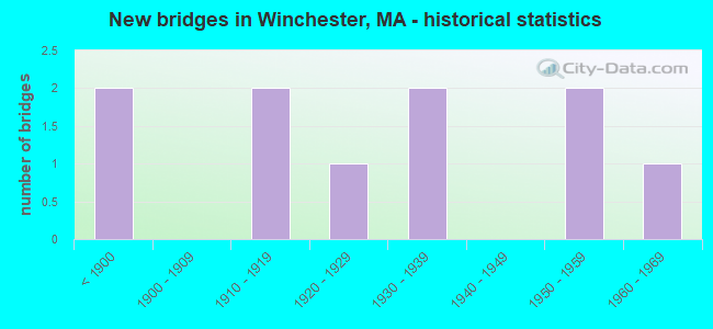
- New bridges - historical statistics
- 2Before 1900
- 21910-1919
- 11920-1929
- 21930-1939
- 21950-1959
- 11960-1969

- Reconstructed bridges - Historical Statistics
- 21980-1989
- 01990-1999
- 02000-2009
- 22010-2019


- Bridge Condition - Deck
- 50.0%Good
- 50.0%Fair

- Bridge Condition - Superstructure
- 25.0%Good
- 50.0%Satisfactory
- 25.0%Fair

- Bridge Condition - Substructure
- 25.0%Good
- 62.5%Satisfactory
- 12.5%Fair

- Bridge Condition - Channel
- 90.0%Good
- 10.0%Satisfactory
Find on map >> Show street view
Structure Number: W400012CFMUNNBI, Location: 1.13 KM W OF MEDFORD (Lat: 42.444336, Lng: -71.138789), Route carried "on" structure: City street , Year Built: 1920, Status: Open, Structure Length: 0.91m (2.99ft), Average Daily Traffic: 15,776 (year 2020), Average Future Daily Traffic: 18,794 (year 2033), Features Intersected: WATER ABERJONA RIVER, Facility Carried by Structure: HWY BACON ST
Minimum Vertical Clearance: 30+ m (98+ ft), Kilometerpoint: 0.901, Lanes on structure: 2, Owner: Town or Township Highway Agency, Approaching Roadway Width: 12.2m (40.0ft), Material/Design: Concrete, Design/Construction: Arch - Deck, Number Of Spans In Main Unit: 1, Length of Maximum Span: 9.1m (29.9ft), Curb or Sidewalk Widths: Left: 2.4m (7.9ft), Right: 2.5m (8.2ft), Curb-To-Curb Width: 12.1m (39.7ft), Out-to-Out Width: 18.2m (59.7ft)
Condition: Superstructure: Satisfactory, Substructure: Good, Channel: Good, Operating Rating: 50.9 metric tons, Method Used To Determine Operating Rating: Load Factor (LF), Inventory Rating: 30.5 metric tons, Method Used To Determine Inventory Rating: Load Factor (LF), Structural Evaluation: Equal to present minimum criteria, Deck Geometry: Somewhat better than minimum adequacy, Waterway Adequacy: Better than present minimum criteria, Approach Roadway Alignment: Equal to present minimum criteria, Length Of Structure Improvement: 1.00m (3.28ft), Designated Inspection Frequency: Every 24 months, Underwater Inspection Frequency: Every 36 months, Inspection Date: March 2020, Underwater Inspection Date: Febuary 2021, Bridge Improvement Cost: $715,000, Roadway Improvement Cost: $72,000, Total Project Cost: $1,073,000 ( Estimate for 2022), Wearing Surface/Protective System: Wearing Surface: Bituminous
Find on map >> Show street view
Structure Number: W400032CGMUNNBI, Location: 1.4 KM W MEDFORD (Lat: 42.451119, Lng: -71.136758), Route carried "on" structure: City street , Year Built: 1915, Status: Open, Structure Length: 1.07m (3.51ft), Average Daily Traffic: 9,800 (year 2017), Truck Traffic: 10%, Average Future Daily Traffic: 23,279 (year 2032), Features Intersected: WATER ABERJONA RIVER, Facility Carried by Structure: HWY WATERFLD RD
Minimum Vertical Clearance: 30+ m (98+ ft), Kilometerpoint: 0.177, Lanes on structure: 2, Owner: Town or Township Highway Agency, Approaching Roadway Width: 10.7m (35.1ft), Material/Design: Concrete, Design/Construction: Arch - Deck, Number Of Spans In Main Unit: 1, Length of Maximum Span: 10.7m (35.1ft), Curb or Sidewalk Widths: Left: 1.8m (5.9ft), Right: 2.7m (8.9ft), Curb-To-Curb Width: 10.7m (35.1ft), Out-to-Out Width: 16.6m (54.5ft)
Condition: Superstructure: Satisfactory, Substructure: Satisfactory, Channel: Good, Operating Rating: 95.3 metric tons, Method Used To Determine Operating Rating: Load Factor (LF), Inventory Rating: 57.1 metric tons, Method Used To Determine Inventory Rating: Load Factor (LF), Structural Evaluation: Equal to present minimum criteria, Deck Geometry: Meets minimum limits, Waterway Adequacy: Better than present minimum criteria, Approach Roadway Alignment: Somewhat better than minimum adequacy, Length Of Structure Improvement: 1.10m (3.61ft), Designated Inspection Frequency: Every 24 months, Underwater Inspection Frequency: Every 36 months, Inspection Date: December 2021, Underwater Inspection Date: Febuary 2022, Bridge Improvement Cost: $281,000, Roadway Improvement Cost: $29,000, Total Project Cost: $422,000 ( Estimate for 2022), Wearing Surface/Protective System: Wearing Surface: Bituminous
Find on map >> Show street view
Structure Number: W400042DAMUNNBI, Location: .16 KM. E. OF RT. 38 (Lat: 42.451653, Lng: -71.136036), Route carried "on" structure: City street , Year Built: 1915, Status: Open, Structure Length: 1.07m (3.51ft), Average Daily Traffic: 10,732 (year 2019), Truck Traffic: 10%, Average Future Daily Traffic: 14,909 (year 2032), Features Intersected: WATER ABERJONA RIVER, Facility Carried by Structure: ST 38 MAIN ST
Minimum Vertical Clearance: 30+ m (98+ ft), Kilometerpoint: 1.867, Lanes on structure: 2, Owner: Town or Township Highway Agency, Approaching Roadway Width: 15.2m (49.9ft), Material/Design: Concrete, Design/Construction: Arch - Deck, Number Of Spans In Main Unit: 1, Length of Maximum Span: 10.7m (35.1ft), Curb or Sidewalk Widths: Left: 3.0m (9.8ft), Right: 3.0m (9.8ft), Curb-To-Curb Width: 15.2m (49.9ft), Out-to-Out Width: 22.3m (73.2ft)
Condition: Superstructure: Satisfactory, Substructure: Satisfactory, Channel: Good, Inventory Rating: 92.0 metric tons, Method Used To Determine Inventory Rating: Allowable Stress (AS), Structural Evaluation: Equal to present minimum criteria, Deck Geometry: Superior to present desirable criteria, Waterway Adequacy: Better than present minimum criteria, Approach Roadway Alignment: Equal to present desirable criteria, Length Of Structure Improvement: 1.10m (3.61ft), Designated Inspection Frequency: Every 24 months, Underwater Inspection Frequency: Every 36 months, Inspection Date: December 2021, Underwater Inspection Date: March 2020, Bridge Improvement Cost: $193,000, Roadway Improvement Cost: $20,000, Total Project Cost: $290,000 ( Estimate for 2022), Wearing Surface/Protective System: Wearing Surface: Bituminous
Find on map >> Show street view
Structure Number: W400122CHMUNNBI, Location: .48 KM S. OF WOBURN (Lat: 42.469394, Lng: -71.125028), Route carried "on" structure: City street , Year Built: 1934, Status: Open, Structure Length: 0.76m (2.49ft), Average Daily Traffic: 18,233 (year 2020), Truck Traffic: 6%, Average Future Daily Traffic: 36,798 (year 2033), Design Load: HS 20, Features Intersected: WATER ABERJONA RIVER, Facility Carried by Structure: HWY WASHNGTON ST
Minimum Vertical Clearance: 30+ m (98+ ft), Kilometerpoint: 2.285, Lanes on structure: 2, Owner: Town or Township Highway Agency, Approaching Roadway Width: 9.1m (29.9ft), Material/Design: Concrete, Design/Construction: Slab, Number Of Spans In Main Unit: 1, Length of Maximum Span: 6.4m (21.0ft), Curb or Sidewalk Widths: Left: 3.0m (9.8ft), Right: 3.0m (9.8ft), Curb-To-Curb Width: 9.1m (29.9ft), Out-to-Out Width: 16.1m (52.8ft)
Condition: Deck: Fair, Superstructure: Fair, Substructure: Satisfactory, Channel: Good, Operating Rating: 69.7 metric tons, Method Used To Determine Operating Rating: Load Factor (LF), Inventory Rating: 41.8 metric tons, Method Used To Determine Inventory Rating: Load Factor (LF), Structural Evaluation: Somewhat better than minimum adequacy, Deck Geometry: High priority of corrective action, Waterway Adequacy: Better than present minimum criteria, Approach Roadway Alignment: Equal to present minimum criteria, Length Of Structure Improvement: 0.80m (2.62ft), Designated Inspection Frequency: Every 24 months, Underwater Inspection Frequency: Every 36 months, Inspection Date: March 2020, Underwater Inspection Date: December 2020, Bridge Improvement Cost: $506,000, Roadway Improvement Cost: $51,000, Total Project Cost: $760,000 ( Estimate for 2022), Deck Structure Type: Concrete Cast-file-Place, Wearing Surface/Protective System: Wearing Surface: Bituminous
Find on map >> Show street view
Structure Number: W400132CJMUNNBI, Location: BTW TWN HALL & FIRE STA. (Lat: 42.452950, Lng: -71.135339), Route carried "on" structure: City street , Year Built: 1890, Year Reconstructed: 2016, Status: Open, Structure Length: 1.36m (4.46ft), Average Daily Traffic: 10,600 (year 2019), Truck Traffic: 2%, Average Future Daily Traffic: 23,279 (year 2032), Features Intersected: WATER ABERJONA RIVER, Facility Carried by Structure: HWY MT VERNON ST
Minimum Vertical Clearance: 30+ m (98+ ft), Kilometerpoint: 0.225, Lanes on structure: 2, Owner: Town or Township Highway Agency, Approaching Roadway Width: 11.3m (37.1ft), Material/Design: Masonry, Design/Construction: Slab, Number Of Spans In Main Unit: 4, Length of Maximum Span: 2.4m (7.9ft), Curb or Sidewalk Widths: Left: 2.6m (8.5ft), Right: 2.7m (8.9ft), Curb-To-Curb Width: 11.3m (37.1ft), Out-to-Out Width: 17.2m (56.4ft)
Condition: Superstructure: Satisfactory, Substructure: Satisfactory, Channel: Good, Operating Rating: 43.2 metric tons, Method Used To Determine Operating Rating: Allowable Stress (AS), Inventory Rating: 34.0 metric tons, Method Used To Determine Inventory Rating: Allowable Stress (AS), Structural Evaluation: Equal to present minimum criteria, Deck Geometry: Meets minimum limits, Waterway Adequacy: Better than present minimum criteria, Approach Roadway Alignment: Equal to present desirable criteria, Designated Inspection Frequency: Every 24 months, Underwater Inspection Frequency: Every 48 months, Inspection Date: December 2021, Underwater Inspection Date: Febuary 2021, Wearing Surface/Protective System: Wearing Surface: Bituminous
Find on map >> Show street view
Structure Number: W400144D5DOTNBI, Location: ADJACENT TO BMRR (Lat: 42.442897, Lng: -71.142667), Route carried "on" structure: City street , Year Built: 1896, Year Reconstructed: 1993, Status: Posted for load-capacity, Structure Length: 1.77m (5.81ft), Average Daily Traffic: 6,206 (year 2019), Truck Traffic: 6%, Average Future Daily Traffic: 12,003 (year 2032), Design Load: H 20, Features Intersected: WATER ABERJONA RIVER, Facility Carried by Structure: HWY MYST VAL PKY
Minimum Vertical Clearance: 30+ m (98+ ft), Kilometerpoint: 0.016, Lanes on structure: 2, Owner: State Highway Agency, Approaching Roadway Width: 11.0m (36.1ft), Material/Design: Steel, Design/Construction: Arch - Deck, Number Of Spans In Main Unit: 1, Length of Maximum Span: 15.2m (49.9ft), Curb or Sidewalk Widths: Left: 2.5m (8.2ft), Right: 0.0m, Curb-To-Curb Width: 10.7m (35.1ft), Out-to-Out Width: 14.0m (45.9ft)
Condition: Deck: Good, Superstructure: Good, Substructure: Good, Channel: Good, Operating Rating: 34.0 metric tons, Method Used To Determine Operating Rating: Load Factor (LF), Inventory Rating: 20.3 metric tons, Method Used To Determine Inventory Rating: Load Factor (LF), Structural Evaluation: Somewhat better than minimum adequacy, Deck Geometry: Meets minimum limits, Waterway Adequacy: Equal to present minimum criteria, Approach Roadway Alignment: Meets minimum limits, Length Of Structure Improvement: 1.80m (5.91ft), Designated Inspection Frequency: Every 24 months, Underwater Inspection Frequency: Every 36 months, Inspection Date: August 2021, Underwater Inspection Date: Febuary 2021, Bridge Improvement Cost: $990,000, Roadway Improvement Cost: $100,000, Total Project Cost: $1,486,000 ( Estimate for 2022), Deck Structure Type: Concrete Cast-file-Place, Wearing Surface/Protective System: Wearing Surface: Bituminous, Membrane: Preformed Fabric, Deck Protection: Epoxy Coated Reinforcing
Find on map >> Show street view
Structure Number: W400192DBMUNNBI, Location: BTN. WEDGEPND & RR (Lat: 42.455694, Lng: -71.138111), Route carried "on" structure: State highway 38, Year Built: 1935, Year Reconstructed: 1989, Status: Open, Structure Length: 0.70m (2.30ft), Average Daily Traffic: 14,483 (year 2019), Truck Traffic: 6%, Average Future Daily Traffic: 38,377 (year 2032), Design Load: HS 20, Features Intersected: WATER WEDGE POND OTLT, Facility Carried by Structure: HWY MAIN ST
Minimum Vertical Clearance: 30+ m (98+ ft), Kilometerpoint: 1.368, Lanes on structure: 2, Owner: Town or Township Highway Agency, Approaching Roadway Width: 13.4m (44.0ft), Material/Design: Concrete, Design/Construction: Slab, Number Of Spans In Main Unit: 1, Length of Maximum Span: 6.1m (20.0ft), Curb or Sidewalk Widths: Left: 2.3m (7.5ft), Right: 2.3m (7.5ft), Curb-To-Curb Width: 13.4m (44.0ft), Out-to-Out Width: 18.8m (61.7ft)
Condition: Deck: Good, Superstructure: Good, Substructure: Fair, Channel: Good, Operating Rating: 53.8 metric tons, Method Used To Determine Operating Rating: Allowable Stress (AS), Inventory Rating: 35.5 metric tons, Method Used To Determine Inventory Rating: Allowable Stress (AS), Structural Evaluation: Somewhat better than minimum adequacy, Deck Geometry: Equal to present minimum criteria, Waterway Adequacy: Better than present minimum criteria, Approach Roadway Alignment: Better than present minimum criteria, Length Of Structure Improvement: 0.80m (2.62ft), Designated Inspection Frequency: Every 24 months, Underwater Inspection Frequency: Every 48 months, Inspection Date: August 2021, Underwater Inspection Date: December 2018, Bridge Improvement Cost: $591,000, Roadway Improvement Cost: $60,000, Total Project Cost: $887,000 ( Estimate for 2022), Deck Structure Type: Concrete Cast-file-Place, Wearing Surface/Protective System: Wearing Surface: Bituminous, Membrane: Built-up, Deck Protection: Epoxy Coated Reinforcing
Find on map >> Show street view
Structure Number: W400272CKMUNNBI, Location: 1.4 KM W STONEHAM (Lat: 42.456244, Lng: -71.136272), Route carried "on" structure: City street 38, Year Built: 1955, Status: Open, Structure Length: 1.27m (4.17ft), Average Daily Traffic: 11,800 (year 2019), Truck Traffic: 4%, Average Future Daily Traffic: 30,433 (year 2032), Design Load: HS 20, Features Intersected: WATER ABERJONA RIVER, Facility Carried by Structure: HWY SKILLINGS RD
Minimum Vertical Clearance: 30+ m (98+ ft), Kilometerpoint: 2.752, Lanes on structure: 2, Base Highway Network: Yes, Owner: Town or Township Highway Agency, Approaching Roadway Width: 13.4m (44.0ft), Skew: 4 degrees, Material/Design: Concrete, Design/Construction: Culvert, Number Of Spans In Main Unit: 2, Length of Maximum Span: 6.1m (20.0ft), Curb or Sidewalk Widths: Left: 1.8m (5.9ft), Right: 1.8m (5.9ft), Curb-To-Curb Width: 13.4m (44.0ft), Out-to-Out Width: 17.7m (58.1ft)
Condition: Channel: Satisfactory, Culverts: Fair, Operating Rating: 45.4 metric tons, Method Used To Determine Operating Rating: Load Factor (LF), Inventory Rating: 25.9 metric tons, Method Used To Determine Inventory Rating: Load Factor (LF), Structural Evaluation: Somewhat better than minimum adequacy, Deck Geometry: Equal to present minimum criteria, Waterway Adequacy: Better than present minimum criteria, Approach Roadway Alignment: Equal to present desirable criteria, Length Of Structure Improvement: 1.80m (5.91ft), Designated Inspection Frequency: Every 24 months, Underwater Inspection Frequency: Every 36 months, Inspection Date: December 2021, Underwater Inspection Date: December 2019, Bridge Improvement Cost: $688,000, Roadway Improvement Cost: $69,000, Total Project Cost: $1,033,000 ( Estimate for 2022), Wearing Surface/Protective System: Wearing Surface: Bituminous
Find on map >> Show street view
Structure Number: W400292D8MUNNBI, Location: 45 M W. OF SKILLING RD (Lat: 42.455692, Lng: -71.135686), Route carried "on" structure: City street , Year Built: 1955, Status: Posted for load, Structure Length: 1.22m (4.00ft), Average Daily Traffic: 646 (year 2018), Average Future Daily Traffic: 1,579 (year 2031), Design Load: HS 15, Features Intersected: WATER ABERJONA RIVER, Facility Carried by Structure: HWY SHORE RD
Minimum Vertical Clearance: 30+ m (98+ ft), Kilometerpoint: 0.338, Lanes on structure: 2, Owner: Town or Township Highway Agency, Approaching Roadway Width: 6.7m (22.0ft), Material/Design: Concrete, Design/Construction: Culvert, Number Of Spans In Main Unit: 3, Length of Maximum Span: 4.6m (15.1ft), Curb or Sidewalk Widths: Left: 0.8m (2.6ft), Right: 1.6m (5.2ft), Curb-To-Curb Width: 6.7m (22.0ft), Out-to-Out Width: 9.6m (31.5ft)
Condition: Channel: Good, Culverts: Fair, Operating Rating: 37.6 metric tons, Method Used To Determine Operating Rating: Load Factor (LF), Inventory Rating: 22.4 metric tons, Method Used To Determine Inventory Rating: Load Factor (LF), Structural Evaluation: Somewhat better than minimum adequacy, Deck Geometry: High priority of replacement, Waterway Adequacy: Equal to present minimum criteria, Approach Roadway Alignment: Better than present minimum criteria, Length Of Structure Improvement: 0.70m (2.30ft), Designated Inspection Frequency: Every 24 months, Underwater Inspection Frequency: Every 36 months, Inspection Date: August 2020, Underwater Inspection Date: December 2018, Bridge Improvement Cost: $336,000, Roadway Improvement Cost: $34,000, Total Project Cost: $505,000 ( Estimate for 2022), Deck Structure Type: Concrete Cast-file-Place, Wearing Surface/Protective System: Wearing Surface: Bituminous
Find on map >> Show street view
Structure Number: W400312D9MUNNBI, Location: AT ENT LYNCH JR. H.SCHOOL (Lat: 42.461539, Lng: -71.149414), Route carried "on" structure: City street , Year Built: 1960, Year Reconstructed: 2016, Status: Open, Structure Length: 0.94m (3.08ft), Average Daily Traffic: 388 (year 2020), Average Future Daily Traffic: 2,053 (year 2033), Features Intersected: WATER HORN POND BROOK, Facility Carried by Structure: HWY HRN PD BK RD
Minimum Vertical Clearance: 30+ m (98+ ft), Kilometerpoint: 0.016, Lanes on structure: 2, Owner: Town or Township Highway Agency, Approaching Roadway Width: 7.3m (24.0ft), Material/Design: Prestressed concrete, Design/Construction: Slab, Number Of Spans In Main Unit: 1, Length of Maximum Span: 8.8m (28.9ft), Curb or Sidewalk Widths: Left: 2.5m (8.2ft), Right: 0.0m, Curb-To-Curb Width: 6.7m (22.0ft), Out-to-Out Width: 9.8m (32.2ft)
Condition: Deck: Fair, Superstructure: Fair, Substructure: Satisfactory, Channel: Good, Operating Rating: 54.9 metric tons, Method Used To Determine Operating Rating: Load Factor (LF), Inventory Rating: 36.0 metric tons, Method Used To Determine Inventory Rating: Load Factor (LF), Structural Evaluation: Somewhat better than minimum adequacy, Deck Geometry: Meets minimum limits, Waterway Adequacy: Better than present minimum criteria, Approach Roadway Alignment: Better than present minimum criteria, Designated Inspection Frequency: Every 24 months, Inspection Date: March 2020, Deck Structure Type: Concrete Precast Panels, Wearing Surface/Protective System: Wearing Surface: Bituminous, Membrane: Other