Bridge Statistics for Winters, California (CA)
Condition, Traffic, Stress, Structural Evaluation, Project Costs
- National Bridge Inventory (NBI) Statistics
- 32Number of bridges
- 312ft / 95.3mTotal length
- $247,000Total costs
- 170,009Total average daily traffic
- 26,581Total average daily truck traffic
- National Bridge Inventory (NBI) Registered Bridges for Winters
- No street view available for this location
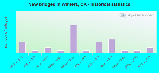
- New bridges - historical statistics
- 41910-1919
- 11920-1929
- 21930-1939
- 11940-1949
- 101950-1959
- 11960-1969
- 41970-1979
- 51980-1989
- 11990-1999
- 12000-2009
- 22010-2019

- Reconstructed bridges - Historical Statistics
- 11950-1959
- 01960-1969
- 01970-1979
- 21980-1989
- 11990-1999


- Bridge Condition - Deck
- 45.8%Good
- 33.3%Satisfactory
- 20.8%Fair

- Bridge Condition - Superstructure
- 68.0%Good
- 20.0%Satisfactory
- 12.0%Fair

- Bridge Condition - Substructure
- 80.0%Good
- 8.0%Satisfactory
- 8.0%Fair
- 4.0%Critical

- Bridge Condition - Channel
- 29.2%Very good
- 12.5%Good
- 37.5%Satisfactory
- 16.7%Fair
- 4.2%Poor
Find on map >> Show street view
Structure Number: 22 0035, Location: 03-YOL-128-6.53 (Lat: 38.511364, Lng: -122.008311), Route carried "on" structure: State highway 128, Year Built: 1915, Year Reconstructed: 1957, Status: Open, Structure Length: 0.82m (2.69ft), Average Daily Traffic: 3,200 (year 2010), Truck Traffic: 6%, Average Future Daily Traffic: 4,067 (year 2041), Features Intersected: SCHOOL DRAW
Minimum Vertical Clearance: 30+ m (98+ ft), Kilometerpoint: 6.530, Lanes on structure: 2, Base Highway Network: Yes (Inventory Route: 1, Subroute: 1), Owner: State Highway Agency, Approaching Roadway Width: 8.5m (27.9ft), Skew: 4 degrees, Material/Design: Concrete, Design/Construction: Slab, Number Of Spans In Main Unit: 1, Length of Maximum Span: 7.3m (24.0ft), Curb-To-Curb Width: 10.5m (34.4ft), Out-to-Out Width: 10.6m (34.8ft)
Condition: Deck: Satisfactory, Superstructure: Satisfactory, Substructure: Good, Channel: Satisfactory, Operating Rating: 40.5 metric tons, Method Used To Determine Operating Rating: Field evaluation and documented engineering judgment, Inventory Rating: 24.3 metric tons, Method Used To Determine Inventory Rating: Field evaluation and documented engineering judgment, Structural Evaluation: Equal to present minimum criteria, Deck Geometry: Somewhat better than minimum adequacy, Waterway Adequacy: Equal to present minimum criteria, Approach Roadway Alignment: Better than present minimum criteria, Designated Inspection Frequency: Every 24 months, Inspection Date: May 2021, Deck Structure Type: Concrete Cast-file-Place, Wearing Surface/Protective System: Wearing Surface: Bituminous
Find on map >> Show street view
Structure Number: 22 0072L, Location: 03-YOL-505-0.01 (Lat: 38.524931, Lng: -121.953061), Route carried "on" structure: Interstate 505, Year Built: 1959, Year Reconstructed: 1980, Status: Open, Structure Length: 12.78m (41.93ft), Average Daily Traffic: 12,000 (year 2010), Truck Traffic: 27%, Average Future Daily Traffic: 16,777 (year 2041), Design Load: HS 20, Features Intersected: PUTAH CRK RD,PUTAH CREEK
Minimum Vertical Clearance: 30+ m (98+ ft), Kilometerpoint: 0.010, Lanes on structure: 2, Lanes under structure: 2, Base Highway Network: Yes (Inventory Route: 5, Subroute: 1), Owner: State Highway Agency, Approaching Roadway Width: 11.7m (38.4ft), Skew: 1 degrees, Material/Design: Concrete continuous, Design/Construction: Box Beam or Girders - Multiple, Number Of Spans In Main Unit: 5, Length of Maximum Span: 27.4m (89.9ft), Curb-To-Curb Width: 11.7m (38.4ft), Out-to-Out Width: 12.8m (42.0ft)
Condition: Deck: Satisfactory, Superstructure: Satisfactory, Substructure: Satisfactory, Channel: Good, Operating Rating: 35.0 metric tons, Method Used To Determine Operating Rating: Load and Resistance Factor Rating (LRFR) rating reported by rating factor(RF) method using HL-93 loadings, Inventory Rating: 27.2 metric tons, Method Used To Determine Inventory Rating: Load and Resistance Factor Rating (LRFR) rating reported by rating factor(RF) method using HL-93 loadings, Structural Evaluation: Equal to present minimum criteria, Deck Geometry: Equal to present minimum criteria, Underclear: Meets minimum limits, Waterway Adequacy: Equal to present desirable criteria, Approach Roadway Alignment: Equal to present desirable criteria, Designated Inspection Frequency: Every 24 months, Inspection Date: May 2021, Deck Structure Type: Concrete Cast-file-Place, Wearing Surface/Protective System: Wearing Surface: Bituminous
Find on map >> Show street view
Structure Number: 22 0072R, Location: 03-YOL-505-0.01 (Lat: 38.525022, Lng: -121.952725), Route carried "on" structure: Interstate 505, Year Built: 1959, Year Reconstructed: 1980, Status: Open, Structure Length: 12.78m (41.93ft), Average Daily Traffic: 13,000 (year 2010), Truck Traffic: 27%, Average Future Daily Traffic: 20,335 (year 2041), Design Load: HS 20, Features Intersected: PUTAH CRK RD,PUTAH CREEK
Minimum Vertical Clearance: 30+ m (98+ ft), Kilometerpoint: 0.010, Lanes on structure: 2, Lanes under structure: 2, Base Highway Network: Yes (Inventory Route: 5, Subroute: 1), Owner: State Highway Agency, Approaching Roadway Width: 11.7m (38.4ft), Skew: 1 degrees, Material/Design: Concrete continuous, Design/Construction: Box Beam or Girders - Multiple, Number Of Spans In Main Unit: 5, Length of Maximum Span: 27.4m (89.9ft), Curb-To-Curb Width: 11.7m (38.4ft), Out-to-Out Width: 12.8m (42.0ft)
Condition: Deck: Satisfactory, Superstructure: Fair, Substructure: Good, Channel: Good, Operating Rating: 42.4 metric tons, Method Used To Determine Operating Rating: Load and Resistance Factor Rating (LRFR) rating reported by rating factor(RF) method using HL-93 loadings, Inventory Rating: 32.7 metric tons, Method Used To Determine Inventory Rating: Load and Resistance Factor Rating (LRFR) rating reported by rating factor(RF) method using HL-93 loadings, Structural Evaluation: Somewhat better than minimum adequacy, Deck Geometry: Equal to present minimum criteria, Underclear: Meets minimum limits, Waterway Adequacy: Equal to present desirable criteria, Approach Roadway Alignment: Equal to present desirable criteria, Designated Inspection Frequency: Every 24 months, Inspection Date: May 2021, Deck Structure Type: Concrete Cast-file-Place, Wearing Surface/Protective System: Wearing Surface: Bituminous
Find on map >> Show street view
Structure Number: 22 011, Location: 03-YOL-128-9.81 (Lat: 38.531203, Lng: -121.953411), Route carried "on" structure: State highway 128, Year Built: 1959, Status: Open, Structure Length: 8.43m (27.66ft), Average Daily Traffic: 12,000 (year 2010), Truck Traffic: 5%, Average Future Daily Traffic: 15,188 (year 2041), Design Load: HS 20, Features Intersected: INTERSTATE 505
Minimum Vertical Clearance: 30+ m (98+ ft), Kilometerpoint: 9.810, Lanes on structure: 2, Lanes under structure: 4, Base Highway Network: Yes (Inventory Route: 1, Subroute: 1), Owner: State Highway Agency, Approaching Roadway Width: 8.5m (27.9ft), Skew: 2 degrees, Material/Design: Concrete continuous, Design/Construction: Box Beam or Girders - Multiple, Number Of Spans In Main Unit: 4, Length of Maximum Span: 29.1m (95.5ft), Curb or Sidewalk Widths: Left: 0.6m (2.0ft), Right: 1.6m (5.2ft), Curb-To-Curb Width: 8.5m (27.9ft), Out-to-Out Width: 11.2m (36.7ft)
Condition: Deck: Satisfactory, Superstructure: Good, Substructure: Satisfactory, Operating Rating: 54.8 metric tons, Method Used To Determine Operating Rating: Load and Resistance Factor Rating (LRFR) rating reported by rating factor(RF) method using HL-93 loadings, Inventory Rating: 42.4 metric tons, Method Used To Determine Inventory Rating: Load and Resistance Factor Rating (LRFR) rating reported by rating factor(RF) method using HL-93 loadings, Structural Evaluation: Equal to present minimum criteria, Deck Geometry: Meets minimum limits, Underclear: Equal to present minimum criteria, Approach Roadway Alignment: Equal to present minimum criteria, Designated Inspection Frequency: Every 48 months, Inspection Date: May 2021, Deck Structure Type: Concrete Cast-file-Place, Wearing Surface/Protective System: Wearing Surface: Integral Concrete
Find on map >> Show street view
Structure Number: 22 0113L, Location: 03-YOL-505-3.37 (Lat: 38.574475, Lng: -121.953269), Route carried "on" structure: Interstate 505, Year Built: 1959, Status: Open, Structure Length: 2.27m (7.45ft), Average Daily Traffic: 12,000 (year 2010), Truck Traffic: 27%, Average Future Daily Traffic: 20,335 (year 2041), Design Load: HS 20, Features Intersected: CHICKAHOMINY SLOUGH
Minimum Vertical Clearance: 30+ m (98+ ft), Kilometerpoint: 3.370, Lanes on structure: 2, Base Highway Network: Yes (Inventory Route: 5, Subroute: 1), Owner: State Highway Agency, Approaching Roadway Width: 12.7m (41.7ft), Material/Design: Concrete continuous, Design/Construction: Slab, Number Of Spans In Main Unit: 3, Length of Maximum Span: 7.3m (24.0ft), Curb-To-Curb Width: 12.7m (41.7ft), Out-to-Out Width: 13.5m (44.3ft)
Condition: Deck: Fair, Superstructure: Fair, Substructure: Good, Channel: Satisfactory, Operating Rating: 56.4 metric tons, Method Used To Determine Operating Rating: Load Factor (LF), Inventory Rating: 34.0 metric tons, Method Used To Determine Inventory Rating: Load Factor (LF), Structural Evaluation: Somewhat better than minimum adequacy, Deck Geometry: Better than present minimum criteria, Waterway Adequacy: Better than present minimum criteria, Approach Roadway Alignment: Equal to present desirable criteria, Designated Inspection Frequency: Every 24 months, Inspection Date: May 2021, Deck Structure Type: Concrete Cast-file-Place, Wearing Surface/Protective System: Wearing Surface: Bituminous
Find on map >> Show street view
Structure Number: 22 0113R, Location: 03-YOL-505-3.37 (Lat: 38.574475, Lng: -121.952975), Route carried "on" structure: Interstate 505, Year Built: 1980, Status: Open, Structure Length: 2.32m (7.61ft), Average Daily Traffic: 12,000 (year 2010), Truck Traffic: 27%, Average Future Daily Traffic: 20,335 (year 2041), Design Load: HS 20, Features Intersected: CHICKAHOMINY SLOUGH
Minimum Vertical Clearance: 30+ m (98+ ft), Kilometerpoint: 3.370, Lanes on structure: 2, Base Highway Network: Yes (Inventory Route: 5, Subroute: 1), Owner: State Highway Agency, Approaching Roadway Width: 11.7m (38.4ft), Material/Design: Concrete continuous, Design/Construction: Slab, Number Of Spans In Main Unit: 3, Length of Maximum Span: 7.3m (24.0ft), Curb-To-Curb Width: 11.7m (38.4ft), Out-to-Out Width: 12.8m (42.0ft)
Condition: Deck: Good, Superstructure: Good, Substructure: Good, Channel: Satisfactory, Operating Rating: 99.8 metric tons, Method Used To Determine Operating Rating: Load Factor (LF), Inventory Rating: 60.9 metric tons, Method Used To Determine Inventory Rating: Load Factor (LF), Structural Evaluation: Better than present minimum criteria, Deck Geometry: Equal to present minimum criteria, Waterway Adequacy: Better than present minimum criteria, Approach Roadway Alignment: Equal to present desirable criteria, Designated Inspection Frequency: Every 24 months, Inspection Date: May 2021, Deck Structure Type: Concrete Cast-file-Place, Wearing Surface/Protective System: Wearing Surface: Integral Concrete
Find on map >> Show street view
Structure Number: 22 0119, Location: 03-YOL-505-1.18 (Lat: 38.542625, Lng: -121.952853), Route carried "on" structure: Interstate 505, Year Built: 1959, Status: Open, Structure Length: 0.67m (2.20ft), Average Daily Traffic: 14,000 (year 2010), Truck Traffic: 27%, Average Future Daily Traffic: 20,335 (year 2041), Features Intersected: DRY SLOUGH
Minimum Vertical Clearance: 30+ m (98+ ft), Kilometerpoint: 1.180, Lanes on structure: 4, Base Highway Network: Yes (Inventory Route: 5, Subroute: 1), Owner: State Highway Agency, Approaching Roadway Width: 39.0m (128.0ft), Skew: 21 degrees, Material/Design: Concrete continuous, Design/Construction: Culvert, Number Of Spans In Main Unit: 2, Length of Maximum Span: 3.0m (9.8ft)
Condition: Channel: Satisfactory, Culverts: Satisfactory, Operating Rating: 54.1 metric tons, Method Used To Determine Operating Rating: Field evaluation and documented engineering judgment, Inventory Rating: 32.4 metric tons, Method Used To Determine Inventory Rating: Field evaluation and documented engineering judgment, Structural Evaluation: Equal to present minimum criteria, Waterway Adequacy: Better than present minimum criteria, Approach Roadway Alignment: Equal to present desirable criteria, Designated Inspection Frequency: Every 24 months, Inspection Date: May 2021
Find on map >> Show street view
Structure Number: 22 016, Location: 03-YOL-505-2.50 (Lat: 38.561792, Lng: -121.953494), Route carried "on" structure: County highway , Year Built: 1980, Status: Open, Structure Length: 6.06m (19.88ft), Average Daily Traffic: 500 (year 2005), Truck Traffic: 10%, Average Future Daily Traffic: 813 (year 2041), Design Load: HS 20+Mod, Features Intersected: INTERSTATE 505, Facility Carried by Structure: COUNTY ROAD 31
Minimum Vertical Clearance: 30+ m (98+ ft), Kilometerpoint: 0.000, Lanes on structure: 2, Lanes under structure: 4, Owner: State Highway Agency, Approaching Roadway Width: 12.2m (40.0ft), Material/Design: Prestressed concrete continuous, Design/Construction: Box Beam or Girders - Multiple, Number Of Spans In Main Unit: 2, Length of Maximum Span: 29.8m (97.8ft), Curb-To-Curb Width: 12.2m (40.0ft), Out-to-Out Width: 13.3m (43.6ft)
Condition: Deck: Satisfactory, Superstructure: Good, Substructure: Good, Operating Rating: 54.1 metric tons, Method Used To Determine Operating Rating: Assigned rating based on Load Factor Design (LFD) reported in metric tons, Inventory Rating: 32.4 metric tons, Method Used To Determine Inventory Rating: Assigned rating based on Load Factor Design (LFD) reported in metric tons, Structural Evaluation: Better than present minimum criteria, Deck Geometry: Equal to present desirable criteria, Underclear: Somewhat better than minimum adequacy, Approach Roadway Alignment: Better than present minimum criteria, Designated Inspection Frequency: Every 48 months, Inspection Date: May 2021, Deck Structure Type: Concrete Cast-file-Place
Find on map >> Show street view
Structure Number: 22 0161, Location: 03-YOL-505-4.03 (Lat: 38.583972, Lng: -121.953600), Route carried "on" structure: County highway , Year Built: 1980, Status: Open, Structure Length: 6.00m (19.69ft), Average Daily Traffic: 250 (year 2005), Truck Traffic: 10%, Average Future Daily Traffic: 808 (year 2041), Design Load: HS 20+Mod, Features Intersected: INTERSTATE 505, Facility Carried by Structure: COUNTY ROAD 29A
Minimum Vertical Clearance: 30+ m (98+ ft), Kilometerpoint: 0.000, Lanes on structure: 2, Lanes under structure: 4, Owner: State Highway Agency, Approaching Roadway Width: 12.2m (40.0ft), Material/Design: Prestressed concrete continuous, Design/Construction: Box Beam or Girders - Multiple, Number Of Spans In Main Unit: 2, Length of Maximum Span: 29.9m (98.1ft), Curb-To-Curb Width: 12.2m (40.0ft), Out-to-Out Width: 13.3m (43.6ft)
Condition: Deck: Good, Superstructure: Good, Substructure: Good, Operating Rating: 54.1 metric tons, Method Used To Determine Operating Rating: Assigned rating based on Load Factor Design (LFD) reported in metric tons, Inventory Rating: 32.4 metric tons, Method Used To Determine Inventory Rating: Assigned rating based on Load Factor Design (LFD) reported in metric tons, Structural Evaluation: Better than present minimum criteria, Deck Geometry: Superior to present desirable criteria, Underclear: Equal to present minimum criteria, Approach Roadway Alignment: Equal to present desirable criteria, Designated Inspection Frequency: Every 48 months, Inspection Date: May 2021, Deck Structure Type: Concrete Cast-file-Place
Find on map >> Show street view
Structure Number: 22 0195, Location: 03-YOL-128-7.70-WIN (Lat: 38.518375, Lng: -121.988864), Route carried "on" structure: State highway 128, Year Built: 2001, Status: Open, Structure Length: 3.51m (11.52ft), Average Daily Traffic: 6,500 (year 2010), Truck Traffic: 6%, Average Future Daily Traffic: 7,931 (year 2041), Design Load: HS 20+Mod, Features Intersected: APRICOT DRAW
Minimum Vertical Clearance: 30+ m (98+ ft), Kilometerpoint: 7.700, Lanes on structure: 2, Base Highway Network: Yes (Inventory Route: 1, Subroute: 1), Owner: State Highway Agency, Approaching Roadway Width: 13.7m (44.9ft), Skew: 4 degrees, Material/Design: Concrete, Design/Construction: Box Beam or Girders - Multiple, Number Of Spans In Main Unit: 1, Length of Maximum Span: 33.9m (111.2ft), Curb or Sidewalk Widths: Left: 1.5m (4.9ft), Right: 0.0m, Curb-To-Curb Width: 13.7m (44.9ft), Out-to-Out Width: 16.0m (52.5ft)
Condition: Deck: Satisfactory, Superstructure: Good, Substructure: Fair, Channel: Very good, Operating Rating: 54.1 metric tons, Method Used To Determine Operating Rating: Assigned rating based on Load Factor Design (LFD) reported in metric tons, Inventory Rating: 32.4 metric tons, Method Used To Determine Inventory Rating: Assigned rating based on Load Factor Design (LFD) reported in metric tons, Structural Evaluation: Somewhat better than minimum adequacy, Deck Geometry: Superior to present desirable criteria, Waterway Adequacy: Equal to present desirable criteria, Approach Roadway Alignment: Equal to present desirable criteria, Designated Inspection Frequency: Every 24 months, Inspection Date: May 2021, Deck Structure Type: Concrete Cast-file-Place
Find on map >> Show street view
Structure Number: 22C003, Location: 0.01 MI N/O C.R. #28 (Lat: 38.605939, Lng: -121.971414), Route carried "on" structure: County highway , Year Built: 1999, Status: Open, Structure Length: 1.11m (3.64ft), Average Daily Traffic: 1,790 (year 2009), Truck Traffic: 10%, Average Future Daily Traffic: 3,218 (year 2043), Design Load: HS 20+Mod, Features Intersected: UNION SCHOOL SLOUGH, Facility Carried by Structure: COUNTY ROAD 89
Minimum Vertical Clearance: 30+ m (98+ ft), Kilometerpoint: 0.000, Lanes on structure: 2, Owner: County Highway Agency, Approaching Roadway Width: 11.0m (36.1ft), Material/Design: Concrete, Design/Construction: Slab, Number Of Spans In Main Unit: 1, Length of Maximum Span: 9.6m (31.5ft), Curb-To-Curb Width: 11.0m (36.1ft), Out-to-Out Width: 11.4m (37.4ft)
Condition: Deck: Good, Superstructure: Good, Substructure: Good, Channel: Very good, Operating Rating: 54.1 metric tons, Method Used To Determine Operating Rating: Assigned rating based on Load Factor Design (LFD) reported in metric tons, Inventory Rating: 32.4 metric tons, Method Used To Determine Inventory Rating: Assigned rating based on Load Factor Design (LFD) reported in metric tons, Structural Evaluation: Better than present minimum criteria, Deck Geometry: Equal to present minimum criteria, Waterway Adequacy: Equal to present desirable criteria, Approach Roadway Alignment: Equal to present desirable criteria, Designated Inspection Frequency: Every 48 months, Inspection Date: November 2021, Deck Structure Type: Concrete Cast-file-Place
Find on map >> Show street view
Structure Number: 22C0044, Location: N OF C.R. # 92 F (Lat: 38.549844, Lng: -121.903764), Route carried "on" structure: County highway , Year Built: 1968, Status: Open, Structure Length: 2.99m (9.81ft), Average Daily Traffic: 4,248 (year 2009), Truck Traffic: 4%, Average Future Daily Traffic: 2,772 (year 2043), Design Load: HS 20, Features Intersected: DRY SLOUGH, Facility Carried by Structure: CO RD 93A
Minimum Vertical Clearance: 30+ m (98+ ft), Kilometerpoint: 0.000, Lanes on structure: 2, Owner: County Highway Agency, Approaching Roadway Width: 11.1m (36.4ft), Skew: 3 degrees, Material/Design: Concrete continuous, Design/Construction: Slab, Number Of Spans In Main Unit: 3, Length of Maximum Span: 10.1m (33.1ft), Curb-To-Curb Width: 11.1m (36.4ft), Out-to-Out Width: 11.8m (38.7ft)
Condition: Deck: Good, Superstructure: Good, Substructure: Good, Channel: Satisfactory, Operating Rating: 37.9 metric tons, Method Used To Determine Operating Rating: Load Factor (LF), Inventory Rating: 22.7 metric tons, Method Used To Determine Inventory Rating: Load Factor (LF), Structural Evaluation: Equal to present minimum criteria, Deck Geometry: Somewhat better than minimum adequacy, Waterway Adequacy: High priority of corrective action, Approach Roadway Alignment: Equal to present desirable criteria, Designated Inspection Frequency: Every 24 months, Inspection Date: October 2021, Deck Structure Type: Concrete Cast-file-Place, Wearing Surface/Protective System: Wearing Surface: Bituminous
Find on map >> Show street view
Structure Number: 22C0105, Location: 2.53 MI W OF C. R. 88 (Lat: 38.596342, Lng: -122.033100), Route carried "on" structure: County highway , Year Built: 1917, Status: Open, Structure Length: 1.17m (3.84ft), Average Daily Traffic: 150 (year 2014), Truck Traffic: 2%, Average Future Daily Traffic: 83 (year 2042), Features Intersected: CHICKAHOMINY SLOUGH, Facility Carried by Structure: C. R. 29
Minimum Vertical Clearance: 30+ m (98+ ft), Kilometerpoint: 0.000, Lanes on structure: 1, Owner: County Highway Agency, Approaching Roadway Width: 5.5m (18.0ft), Material/Design: Concrete, Design/Construction: Tee Beam, Number Of Spans In Main Unit: 1, Length of Maximum Span: 11.0m (36.1ft), Curb-To-Curb Width: 4.9m (16.1ft), Out-to-Out Width: 5.6m (18.4ft)
Condition: Deck: Good, Superstructure: Good, Substructure: Critical, Channel: Poor, Operating Rating: 43.1 metric tons, Method Used To Determine Operating Rating: Load and Resistance Factor Rating (LRFR) rating reported by rating factor(RF) method using HL-93 loadings, Inventory Rating: 33.4 metric tons, Method Used To Determine Inventory Rating: Load and Resistance Factor Rating (LRFR) rating reported by rating factor(RF) method using HL-93 loadings, Structural Evaluation: High priority of replacement, Deck Geometry: High priority of replacement, Waterway Adequacy: Equal to present minimum criteria, Approach Roadway Alignment: High priority of corrective action, Length Of Structure Improvement: 1.17m (3.84ft), Designated Inspection Frequency: Every 24 months, Inspection Date: January 2022, Bridge Improvement Cost: $147,000, Roadway Improvement Cost: $29,000, Total Project Cost: $247,000 ( Estimate for 2017), Deck Structure Type: Concrete Cast-file-Place, Wearing Surface/Protective System: Wearing Surface: Bituminous
Find on map >> Show street view
Structure Number: 22C0106, Location: 0.01 MI S OF S.H. 128 (Lat: 38.511267, Lng: -122.008014), Route carried "on" structure: County highway , Year Built: 1930, Status: Open, Structure Length: 0.67m (2.20ft), Average Daily Traffic: 50 (year 1978), Average Future Daily Traffic: 66 (year 2041), Design Load: H 10, Features Intersected: CREEK S14, Facility Carried by Structure: HORSHOE ST CR 87A
Minimum Vertical Clearance: 30+ m (98+ ft), Kilometerpoint: 0.000, Lanes on structure: 2, Owner: County Highway Agency, Approaching Roadway Width: 4.6m (15.1ft), Skew: 3 degrees, Material/Design: Concrete, Design/Construction: Culvert, Number Of Spans In Main Unit: 1, Length of Maximum Span: 6.4m (21.0ft), Curb-To-Curb Width: 6.2m (20.3ft), Out-to-Out Width: 6.8m (22.3ft)
Condition: Channel: Satisfactory, Culverts: Satisfactory, Operating Rating: 27.2 metric tons, Method Used To Determine Operating Rating: Field evaluation and documented engineering judgment, Inventory Rating: 16.2 metric tons, Method Used To Determine Inventory Rating: Field evaluation and documented engineering judgment, Structural Evaluation: Somewhat better than minimum adequacy, Deck Geometry: Somewhat better than minimum adequacy, Waterway Adequacy: Equal to present minimum criteria, Approach Roadway Alignment: Equal to present desirable criteria, Designated Inspection Frequency: Every 24 months, Inspection Date: October 2021, Deck Structure Type: Concrete Cast-file-Place, Wearing Surface/Protective System: Wearing Surface: Bituminous
Find on map >> Show street view
Structure Number: 22C0109, Location: 0.96 MI S OF C.R. #27 (Lat: 38.606697, Lng: -121.989889), Route carried "on" structure: County highway , Year Built: 1916, Status: Open, Structure Length: 0.82m (2.69ft), Average Daily Traffic: 115 (year 2010), Truck Traffic: 1%, Average Future Daily Traffic: 252 (year 2043), Features Intersected: UNION SCHOOL SLOUGH, Facility Carried by Structure: COUNTY ROAD 88
Minimum Vertical Clearance: 30+ m (98+ ft), Kilometerpoint: 0.000, Lanes on structure: 2, Owner: County Highway Agency, Approaching Roadway Width: 4.3m (14.1ft), Material/Design: Concrete, Design/Construction: Tee Beam, Number Of Spans In Main Unit: 1, Length of Maximum Span: 7.6m (24.9ft), Curb-To-Curb Width: 5.5m (18.0ft), Out-to-Out Width: 6.3m (20.7ft)
Condition: Deck: Satisfactory, Superstructure: Good, Substructure: Fair, Channel: Satisfactory, Operating Rating: 28.2 metric tons, Method Used To Determine Operating Rating: Field evaluation and documented engineering judgment, Inventory Rating: 16.8 metric tons, Method Used To Determine Inventory Rating: Field evaluation and documented engineering judgment, Structural Evaluation: Somewhat better than minimum adequacy, Deck Geometry: High priority of corrective action, Waterway Adequacy: Better than present minimum criteria, Approach Roadway Alignment: Better than present minimum criteria, Designated Inspection Frequency: Every 24 months, Inspection Date: October 2021, Deck Structure Type: Concrete Cast-file-Place, Wearing Surface/Protective System: Wearing Surface: Bituminous
Find on map >> Show street view
Structure Number: 22C011, Location: 0.15 MI N OF C.R. #29 (Lat: 38.593544, Lng: -121.989853), Route carried "on" structure: County highway , Year Built: 1930, Status: Open, Structure Length: 0.64m (2.10ft), Average Daily Traffic: 115 (year 2009), Truck Traffic: 1%, Average Future Daily Traffic: 223 (year 2043), Features Intersected: WINTERS CANAL, Facility Carried by Structure: COUNTY ROAD 88
Minimum Vertical Clearance: 30+ m (98+ ft), Kilometerpoint: 0.000, Lanes on structure: 2, Owner: County Highway Agency, Approaching Roadway Width: 6.4m (21.0ft), Skew: 4 degrees, Material/Design: Concrete, Design/Construction: Slab, Number Of Spans In Main Unit: 1, Length of Maximum Span: 6.1m (20.0ft), Curb-To-Curb Width: 6.4m (21.0ft), Out-to-Out Width: 7.2m (23.6ft)
Condition: Deck: Fair, Superstructure: Fair, Substructure: Good, Channel: Very good, Operating Rating: 27.9 metric tons, Method Used To Determine Operating Rating: Field evaluation and documented engineering judgment, Inventory Rating: 16.5 metric tons, Method Used To Determine Inventory Rating: Field evaluation and documented engineering judgment, Structural Evaluation: Somewhat better than minimum adequacy, Deck Geometry: Meets minimum limits, Waterway Adequacy: Better than present minimum criteria, Approach Roadway Alignment: Better than present minimum criteria, Designated Inspection Frequency: Every 24 months, Inspection Date: October 2021, Deck Structure Type: Concrete Cast-file-Place, Wearing Surface/Protective System: Wearing Surface: Bituminous
Find on map >> Show street view
Structure Number: 22C0112, Location: 0.13 MI E OF C.R. #88 (Lat: 38.591497, Lng: -121.987669), Route carried "on" structure: County highway , Year Built: 1920, Status: Open, Structure Length: 0.67m (2.20ft), Average Daily Traffic: 450 (year 2010), Truck Traffic: 2%, Average Future Daily Traffic: 548 (year 2043), Features Intersected: WINTERS CANAL, Facility Carried by Structure: C.R. #29
Minimum Vertical Clearance: 30+ m (98+ ft), Kilometerpoint: 0.000, Lanes on structure: 2, Owner: County Highway Agency, Approaching Roadway Width: 6.1m (20.0ft), Skew: 4 degrees, Material/Design: Concrete, Design/Construction: Slab, Number Of Spans In Main Unit: 1, Length of Maximum Span: 6.1m (20.0ft), Curb-To-Curb Width: 6.4m (21.0ft), Out-to-Out Width: 7.2m (23.6ft)
Condition: Deck: Good, Superstructure: Good, Substructure: Good, Channel: Satisfactory, Operating Rating: 27.9 metric tons, Method Used To Determine Operating Rating: Field evaluation and documented engineering judgment, Inventory Rating: 16.8 metric tons, Method Used To Determine Inventory Rating: Field evaluation and documented engineering judgment, Structural Evaluation: Somewhat better than minimum adequacy, Deck Geometry: High priority of corrective action, Waterway Adequacy: Better than present minimum criteria, Approach Roadway Alignment: Equal to present desirable criteria, Designated Inspection Frequency: Every 24 months, Inspection Date: October 2021, Deck Structure Type: Concrete Cast-file-Place, Wearing Surface/Protective System: Wearing Surface: Bituminous
Find on map >> Show street view
Structure Number: 22C0113, Location: 0.51 MI N OF C.R. #31 (Lat: 38.568517, Lng: -121.941164), Route carried "on" structure: County highway , Year Built: 1957, Status: Open, Structure Length: 1.04m (3.41ft), Average Daily Traffic: 22 (year 2003), Truck Traffic: 4%, Average Future Daily Traffic: 58 (year 2043), Features Intersected: CHICKAHOMINY SLOUGH, Facility Carried by Structure: BUCKEYE ROAD
Minimum Vertical Clearance: 30+ m (98+ ft), Kilometerpoint: 0.000, Lanes on structure: 2, Owner: County Highway Agency, Approaching Roadway Width: 9.1m (29.9ft), Skew: 1 degrees, Material/Design: Concrete, Design/Construction: Tee Beam, Number Of Spans In Main Unit: 1, Length of Maximum Span: 9.4m (30.8ft), Curb or Sidewalk Widths: Left: 0.2m (0.7ft), Right: 0.2m (0.7ft), Curb-To-Curb Width: 9.1m (29.9ft), Out-to-Out Width: 9.5m (31.2ft)
Condition: Deck: Good, Superstructure: Good, Substructure: Good, Channel: Good, Operating Rating: 35.0 metric tons, Method Used To Determine Operating Rating: Field evaluation and documented engineering judgment, Inventory Rating: 21.1 metric tons, Method Used To Determine Inventory Rating: Field evaluation and documented engineering judgment, Structural Evaluation: Equal to present minimum criteria, Deck Geometry: Better than present minimum criteria, Waterway Adequacy: Better than present minimum criteria, Approach Roadway Alignment: Somewhat better than minimum adequacy, Designated Inspection Frequency: Every 24 months, Inspection Date: October 2021, Deck Structure Type: Concrete Cast-file-Place
Find on map >> Show street view
Structure Number: 22C0118, Location: 0.27 MI W OF C.R. 91A (Lat: 38.561897, Lng: -121.934572), Route carried "on" structure: County highway , Year Built: 1976, Status: Open, Structure Length: 0.91m (2.99ft), Average Daily Traffic: 586 (year 2009), Truck Traffic: 15%, Average Future Daily Traffic: 639 (year 2043), Design Load: HS 20, Features Intersected: CHICKHOMINY SLOUGH, Facility Carried by Structure: COUNTY ROAD 31
Minimum Vertical Clearance: 30+ m (98+ ft), Kilometerpoint: 0.000, Lanes on structure: 2, Owner: County Highway Agency, Approaching Roadway Width: 8.5m (27.9ft), Skew: 2 degrees, Material/Design: Concrete, Design/Construction: Slab, Number Of Spans In Main Unit: 1, Length of Maximum Span: 8.8m (28.9ft), Curb-To-Curb Width: 8.5m (27.9ft), Out-to-Out Width: 8.9m (29.2ft)
Condition: Deck: Good, Superstructure: Good, Substructure: Good, Channel: Satisfactory, Operating Rating: 99.8 metric tons, Method Used To Determine Operating Rating: Load Factor (LF), Inventory Rating: 75.2 metric tons, Method Used To Determine Inventory Rating: Load Factor (LF), Structural Evaluation: Better than present minimum criteria, Deck Geometry: Somewhat better than minimum adequacy, Waterway Adequacy: Meets minimum limits, Approach Roadway Alignment: Equal to present desirable criteria, Designated Inspection Frequency: Every 24 months, Inspection Date: October 2021, Deck Structure Type: Concrete Cast-file-Place
Find on map >> Show street view
Structure Number: 22C0119, Location: 0.77 MI N OF I 505 RAMP (Lat: 38.542861, Lng: -121.953303), Route carried "on" structure: County highway , Year Built: 1970, Status: Open, Structure Length: 0.73m (2.40ft), Average Daily Traffic: 40 (year 2011), Average Future Daily Traffic: 55 (year 2043), Features Intersected: DRY SLOUGH, Facility Carried by Structure: C.R. #90
Minimum Vertical Clearance: 30+ m (98+ ft), Kilometerpoint: 0.000, Lanes on structure: 2, Owner: County Highway Agency, Approaching Roadway Width: 6.1m (20.0ft), Skew: 1 degrees, Material/Design: Concrete continuous, Design/Construction: Culvert, Number Of Spans In Main Unit: 2, Length of Maximum Span: 3.4m (11.2ft)
Condition: Channel: Fair, Culverts: Satisfactory, Operating Rating: 40.5 metric tons, Method Used To Determine Operating Rating: Field evaluation and documented engineering judgment, Inventory Rating: 24.3 metric tons, Method Used To Determine Inventory Rating: Field evaluation and documented engineering judgment, Structural Evaluation: Equal to present minimum criteria, Waterway Adequacy: Better than present minimum criteria, Approach Roadway Alignment: Equal to present desirable criteria, Designated Inspection Frequency: Every 24 months, Inspection Date: October 2021
Find on map >> Show street view
Structure Number: 22C012, Location: 0.83 MI N OF SR 128 (Lat: 38.542544, Lng: -121.952542), Route carried "on" structure: County highway , Year Built: 1947, Status: Open, Structure Length: 1.46m (4.79ft), Average Daily Traffic: 121 (year 2009), Truck Traffic: 3%, Average Future Daily Traffic: 217 (year 2043), Features Intersected: DRY SLOUGH, Facility Carried by Structure: CR 90A(BUCKEYE RD)
Minimum Vertical Clearance: 30+ m (98+ ft), Kilometerpoint: 0.000, Lanes on structure: 2, Owner: County Highway Agency, Approaching Roadway Width: 7.4m (24.3ft), Material/Design: Concrete continuous, Design/Construction: Slab, Number Of Spans In Main Unit: 2, Length of Maximum Span: 7.0m (23.0ft), Curb or Sidewalk Widths: Left: 0.4m (1.3ft), Right: 0.4m (1.3ft), Curb-To-Curb Width: 7.4m (24.3ft), Out-to-Out Width: 9.1m (29.9ft)
Condition: Deck: Good, Superstructure: Good, Substructure: Good, Channel: Fair, Operating Rating: 57.7 metric tons, Method Used To Determine Operating Rating: Load Factor (LF), Inventory Rating: 34.3 metric tons, Method Used To Determine Inventory Rating: Load Factor (LF), Structural Evaluation: Better than present minimum criteria, Deck Geometry: Somewhat better than minimum adequacy, Waterway Adequacy: Better than present minimum criteria, Approach Roadway Alignment: Equal to present desirable criteria, Designated Inspection Frequency: Every 24 months, Inspection Date: October 2021, Deck Structure Type: Concrete Cast-file-Place, Wearing Surface/Protective System: Wearing Surface: Bituminous
Find on map >> Show street view
Structure Number: 22C0121, Location: 0.06 MI N OF C.R. #32 (Lat: 38.540703, Lng: -121.929350), Route carried "on" structure: County highway , Year Built: 1913, Status: Open, Structure Length: 0.70m (2.30ft), Average Daily Traffic: 100 (year 2011), Truck Traffic: 10%, Average Future Daily Traffic: 163 (year 2043), Features Intersected: DRY SLOUGH, Facility Carried by Structure: C.R. #91A
Minimum Vertical Clearance: 30+ m (98+ ft), Kilometerpoint: 0.000, Lanes on structure: 2, Owner: County Highway Agency, Approaching Roadway Width: 5.8m (19.0ft), Skew: 2 degrees, Material/Design: Concrete, Design/Construction: Arch - Deck, Number Of Spans In Main Unit: 1, Length of Maximum Span: 6.7m (22.0ft), Curb-To-Curb Width: 5.8m (19.0ft), Out-to-Out Width: 6.7m (22.0ft)
Condition: Superstructure: Satisfactory, Substructure: Good, Channel: Fair, Operating Rating: 26.9 metric tons, Method Used To Determine Operating Rating: Field evaluation and documented engineering judgment, Inventory Rating: 16.2 metric tons, Method Used To Determine Inventory Rating: Field evaluation and documented engineering judgment, Structural Evaluation: Somewhat better than minimum adequacy, Deck Geometry: Meets minimum limits, Waterway Adequacy: Equal to present minimum criteria, Approach Roadway Alignment: Equal to present desirable criteria, Designated Inspection Frequency: Every 24 months, Inspection Date: October 2021
Find on map >> Show street view
Structure Number: 22C0187, Location: 0.37 N OF CR 33 (Lat: 38.536111, Lng: -121.971111), Route carried "on" structure: City street , Year Built: 2015, Status: Open, Structure Length: 1.43m (4.69ft), Average Daily Traffic: 2,100 (year 2010), Truck Traffic: 5%, Average Future Daily Traffic: 3,387 (year 2043), Design Load: HL 93, Features Intersected: DRY SLOUGH, Facility Carried by Structure: RAILROAD AVE(CR89)
Minimum Vertical Clearance: 30+ m (98+ ft), Kilometerpoint: 0.000, Lanes on structure: 2, Owner: City or Municipal Highway Agency, Approaching Roadway Width: 9.8m (32.2ft), Material/Design: Prestressed concrete, Design/Construction: Slab, Number Of Spans In Main Unit: 1, Length of Maximum Span: 14.3m (46.9ft), Curb-To-Curb Width: 9.8m (32.2ft), Out-to-Out Width: 10.8m (35.4ft)
Condition: Deck: Satisfactory, Superstructure: Satisfactory, Substructure: Good, Channel: Fair, Operating Rating: 42.1 metric tons, Method Used To Determine Operating Rating: Assigned ratings based on Load and Resistance Factor Design (LRFD) reported by rating factor (RF) using HL93 loadings, Inventory Rating: 32.4 metric tons, Method Used To Determine Inventory Rating: Assigned ratings based on Load and Resistance Factor Design (LRFD) reported by rating factor (RF) using HL93 loadings, Structural Evaluation: Equal to present minimum criteria, Deck Geometry: Meets minimum limits, Waterway Adequacy: Equal to present desirable criteria, Approach Roadway Alignment: Equal to present desirable criteria, Designated Inspection Frequency: Every 24 months, Inspection Date: November 2021, Deck Structure Type: Concrete Cast-file-Place
Find on map >> Show street view
Structure Number: 23 0170R, Location: 04-SOL-505-R8.55 (Lat: 38.495786, Lng: -121.949511), Route carried "on" structure: Interstate 505, Year Built: 1974, Status: Open, Structure Length: 2.71m (8.89ft), Average Daily Traffic: 11,400 (year 2009), Truck Traffic: 10%, Average Future Daily Traffic: 18,587 (year 2040), Design Load: HS 20, Features Intersected: WOLFSKILL RD
Minimum Vertical Clearance: 30+ m (98+ ft), Kilometerpoint: 8.550, Lanes on structure: 2, Lanes under structure: 2, Base Highway Network: Yes (Inventory Route: 5, Subroute: 1), Owner: State Highway Agency, Approaching Roadway Width: 12.2m (40.0ft), Skew: 1 degrees, Material/Design: Prestressed concrete, Design/Construction: Box Beam or Girders - Multiple, Number Of Spans In Main Unit: 1, Length of Maximum Span: 26.8m (87.9ft), Curb-To-Curb Width: 12.2m (40.0ft), Out-to-Out Width: 12.8m (42.0ft)
Condition: Deck: Fair, Superstructure: Satisfactory, Substructure: Good, Operating Rating: 44.7 metric tons, Method Used To Determine Operating Rating: Load and Resistance Factor Rating (LRFR) rating reported by rating factor(RF) method using HL-93 loadings, Inventory Rating: 32.7 metric tons, Method Used To Determine Inventory Rating: Load and Resistance Factor Rating (LRFR) rating reported by rating factor(RF) method using HL-93 loadings, Structural Evaluation: Equal to present minimum criteria, Deck Geometry: Better than present minimum criteria, Underclear: Somewhat better than minimum adequacy, Approach Roadway Alignment: Equal to present desirable criteria, Designated Inspection Frequency: Every 24 months, Inspection Date: March 2020, Deck Structure Type: Concrete Cast-file-Place
Find on map >> Show street view
Structure Number: 23C0099, Location: 3.0 MI W WINTERS RD (Lat: 38.492900, Lng: -122.004497), Route carried "on" structure: County highway , Year Built: 1957, Status: Open, Structure Length: 3.08m (10.10ft), Average Daily Traffic: 650 (year 2010), Truck Traffic: 6%, Average Future Daily Traffic: 695 (year 2042), Features Intersected: PUTAH SOUTH CANAL, Facility Carried by Structure: PUTAH CREEK RD
Minimum Vertical Clearance: 30+ m (98+ ft), Kilometerpoint: 0.000, Lanes on structure: 2, Owner: County Highway Agency, Approaching Roadway Width: 6.7m (22.0ft), Skew: 1 degrees, Material/Design: Concrete continuous, Design/Construction: Tee Beam, Number Of Spans In Main Unit: 3, Length of Maximum Span: 11.6m (38.1ft), Curb-To-Curb Width: 8.0m (26.2ft), Out-to-Out Width: 8.6m (28.2ft)
Condition: Deck: Good, Superstructure: Good, Substructure: Good, Channel: Very good, Operating Rating: 31.4 metric tons, Method Used To Determine Operating Rating: Field evaluation and documented engineering judgment, Inventory Rating: 18.8 metric tons, Method Used To Determine Inventory Rating: Field evaluation and documented engineering judgment, Structural Evaluation: Somewhat better than minimum adequacy, Deck Geometry: Somewhat better than minimum adequacy, Waterway Adequacy: Superior to present desirable criteria, Approach Roadway Alignment: Better than present minimum criteria, Designated Inspection Frequency: Every 24 months, Inspection Date: October 2020, Deck Structure Type: Concrete Cast-file-Place, Wearing Surface/Protective System: Wearing Surface: Bituminous
Find on map >> Show street view
Structure Number: 23C0196, Location: 0.30 MI SW PUTAH CREEK RD (Lat: 38.493553, Lng: -121.986947), Route carried "on" structure: County highway , Year Built: 1955, Status: Open, Structure Length: 1.55m (5.09ft), Average Daily Traffic: 193 (year 2012), Truck Traffic: 2%, Average Future Daily Traffic: 392 (year 2042), Features Intersected: PUTAH SOUTH CANAL, Facility Carried by Structure: HOLMES LANE
Minimum Vertical Clearance: 30+ m (98+ ft), Kilometerpoint: 0.000, Lanes on structure: 2, Owner: County Highway Agency, Approaching Roadway Width: 5.2m (17.1ft), Material/Design: Concrete, Design/Construction: Slab, Number Of Spans In Main Unit: 2, Length of Maximum Span: 7.6m (24.9ft), Curb or Sidewalk Widths: Left: 0.2m (0.7ft), Right: 0.2m (0.7ft), Curb-To-Curb Width: 6.7m (22.0ft), Out-to-Out Width: 7.3m (24.0ft)
Condition: Deck: Good, Superstructure: Good, Substructure: Good, Channel: Very good, Operating Rating: 48.3 metric tons, Method Used To Determine Operating Rating: Load Factor (LF), Inventory Rating: 28.8 metric tons, Method Used To Determine Inventory Rating: Load Factor (LF), Structural Evaluation: Better than present minimum criteria, Deck Geometry: Meets minimum limits, Waterway Adequacy: Superior to present desirable criteria, Approach Roadway Alignment: Equal to present desirable criteria, Designated Inspection Frequency: Every 24 months, Inspection Date: October 2020, Deck Structure Type: Concrete Cast-file-Place
Find on map >> Show street view
Structure Number: 23C0197, Location: 0.10 MI SW PUTAH CREEK RD (Lat: 38.493200, Lng: -121.998300), Route carried "on" structure: County highway , Year Built: 1955, Year Reconstructed: 1999, Status: Open, Structure Length: 3.51m (11.52ft), Average Daily Traffic: 404 (year 2009), Truck Traffic: 2%, Average Future Daily Traffic: 600 (year 2041), Features Intersected: PUTAH SOUTH CANAL, Facility Carried by Structure: OLIVE SCHOOL LANE
Minimum Vertical Clearance: 30+ m (98+ ft), Kilometerpoint: 0.000, Lanes on structure: 2, Owner: County Highway Agency, Approaching Roadway Width: 5.5m (18.0ft), Material/Design: Concrete continuous, Design/Construction: Girder and Floorbeam System, Number Of Spans In Main Unit: 3, Length of Maximum Span: 15.2m (49.9ft), Curb or Sidewalk Widths: Left: 0.2m (0.7ft), Right: 0.2m (0.7ft), Curb-To-Curb Width: 7.9m (25.9ft), Out-to-Out Width: 8.5m (27.9ft)
Condition: Deck: Fair, Superstructure: Good, Substructure: Good, Channel: Very good, Operating Rating: 28.5 metric tons, Method Used To Determine Operating Rating: Field evaluation and documented engineering judgment, Inventory Rating: 17.2 metric tons, Method Used To Determine Inventory Rating: Field evaluation and documented engineering judgment, Structural Evaluation: Somewhat better than minimum adequacy, Deck Geometry: Somewhat better than minimum adequacy, Waterway Adequacy: Superior to present desirable criteria, Approach Roadway Alignment: Equal to present desirable criteria, Designated Inspection Frequency: Every 24 months, Inspection Date: March 2021, Deck Structure Type: Concrete Cast-file-Place, Wearing Surface/Protective System: Wearing Surface: Bituminous
Find on map >> Show street view
Structure Number: 23C0285, Location: 0.5 MILE SOUTH OF SH128 (Lat: 38.519444, Lng: -121.967500), Route carried "on" structure: County highway , Year Built: 2016, Status: Open, Structure Length: 14.42m (47.31ft), Average Daily Traffic: 525 (year 2013), Truck Traffic: 8%, Average Future Daily Traffic: 614 (year 2042), Design Load: HL 93, Features Intersected: PUTAH CREEK, Facility Carried by Structure: WINTERS ROAD
Minimum Vertical Clearance: 30+ m (98+ ft), Kilometerpoint: 0.000, Lanes on structure: 2, Owner: County Highway Agency, Approaching Roadway Width: 9.8m (32.2ft), Skew: 9 degrees, Material/Design: Concrete continuous, Design/Construction: Box Beam or Girders - Multiple, Number Of Spans In Main Unit: 5, Length of Maximum Span: 36.6m (120.1ft), Curb or Sidewalk Widths: Left: 1.5m (4.9ft), Right: 0.0m, Curb-To-Curb Width: 9.8m (32.2ft), Out-to-Out Width: 12.3m (40.4ft)
Condition: Deck: Fair, Superstructure: Good, Substructure: Good, Channel: Very good, Operating Rating: 42.1 metric tons, Method Used To Determine Operating Rating: Assigned ratings based on Load and Resistance Factor Design (LRFD) reported by rating factor (RF) using HL93 loadings, Inventory Rating: 32.4 metric tons, Method Used To Determine Inventory Rating: Assigned ratings based on Load and Resistance Factor Design (LRFD) reported by rating factor (RF) using HL93 loadings, Structural Evaluation: Better than present minimum criteria, Deck Geometry: Equal to present minimum criteria, Waterway Adequacy: Equal to present desirable criteria, Approach Roadway Alignment: Equal to present desirable criteria, Designated Inspection Frequency: Every 24 months, Inspection Date: August 2020, Deck Structure Type: Concrete Cast-file-Place
Find on map >> Show street view
Structure Number: 22 011, Location: 03-YOL-128-9.81 (Lat: 38.531203, Lng: -121.953411), Route carried "under" structure: Interstate 505, Year Built: 1959, Structure Length: 0. m, Average Daily Traffic: 24,000 (year 2010), Truck Traffic: 27%, Features Intersected: INTERSTATE 505, Facility Carried by Structure: STATE ROUTE 128
Minimum Vertical Clearance: 5.02m (16.47ft), Kilometerpoint: 0.400, Lanes on structure: 2, Lanes under structure: 4, Material/Design: Concrete continuous, Design/Construction: Box Beam or Girders - Multiple, Length of Maximum Span: 29.1m (95.5ft)
Find on map >> Show street view
Structure Number: 22 016, Location: 03-YOL-505-2.50 (Lat: 38.561792, Lng: -121.953494), Route carried "under" structure: Interstate 505, Year Built: 1980, Structure Length: 0. m, Average Daily Traffic: 18,400 (year 2009), Features Intersected: INTERSTATE 505, Facility Carried by Structure: COUNTY ROAD 31
Minimum Vertical Clearance: 4.97m (16.31ft), Kilometerpoint: 2.500, Lanes on structure: 2, Lanes under structure: 4, Material/Design: Prestressed concrete continuous, Design/Construction: Box Beam or Girders - Multiple, Length of Maximum Span: 29.8m (97.8ft)
Find on map >> Show street view
Structure Number: 22 0161, Location: 03-YOL-505-4.03 (Lat: 38.583972, Lng: -121.953600), Route carried "under" structure: Interstate 505, Year Built: 1980, Structure Length: 0. m, Average Daily Traffic: 18,400 (year 2009), Features Intersected: INTERSTATE 505, Facility Carried by Structure: COUNTY ROAD 29A
Minimum Vertical Clearance: 5.05m (16.57ft), Kilometerpoint: 4.030, Lanes on structure: 2, Lanes under structure: 4, Material/Design: Prestressed concrete continuous, Design/Construction: Box Beam or Girders - Multiple, Length of Maximum Span: 29.9m (98.1ft)
Find on map >> Show street view
Structure Number: 23 0170L, Location: 04-SOL-505-R8.54 (Lat: 38.495689, Lng: -121.949800), Route carried "under" structure: County highway , Year Built: 1974, Structure Length: 0. m, Average Daily Traffic: 700 (year 1998), Truck Traffic: 5%, Features Intersected: WOLFSKILL RD, Facility Carried by Structure: INTERSTATE 505 SB
Minimum Vertical Clearance: 4.62m (15.16ft), Kilometerpoint: 0.000, Lanes on structure: 2, Lanes under structure: 2, Material/Design: Prestressed concrete, Design/Construction: Box Beam or Girders - Multiple, Length of Maximum Span: 27.1m (88.9ft)