Bridge Statistics for Winton, North Carolina (NC)
Condition, Traffic, Stress, Structural Evaluation, Project Costs
- National Bridge Inventory (NBI) Statistics
- 11Number of bridges
- 256ft / 78.3mTotal length
- 29,260Total average daily traffic
- 3,425Total average daily truck traffic
- National Bridge Inventory (NBI) Registered Bridges for Winton
- No street view available for this location
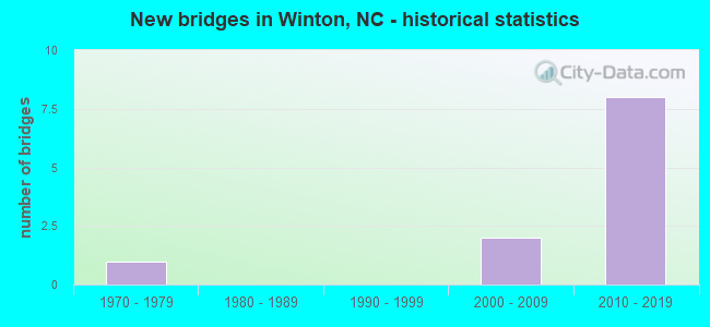
- New bridges - historical statistics
- 11970-1979
- 22000-2009
- 82010-2019


- Bridge Condition - Deck
- 60.0%Very good
- 20.0%Good
- 20.0%Satisfactory

- Bridge Condition - Superstructure
- 60.0%Very good
- 20.0%Good
- 20.0%Satisfactory

- Bridge Condition - Substructure
- 60.0%Very good
- 20.0%Good
- 20.0%Fair

- Bridge Condition - Channel
- 80.0%Good
- 20.0%Satisfactory
Find on map >> Show street view
Structure Number: 73004, Location: .06 MI.W.JCT.US13 (Lat: 36.439978, Lng: -76.898003), Route carried "on" structure: State highway 1200, Year Built: 2000, Status: Open, Structure Length: 0.70m (2.30ft), Average Daily Traffic: 210 (year 2011), Truck Traffic: 6%, Average Future Daily Traffic: 420 (year 2040), Design Load: HS 20+Mod, Features Intersected: BUCKHORN CREEK
Minimum Vertical Clearance: 30+ m (98+ ft), Kilometerpoint: 0.000, Lanes on structure: 2, Owner: State Highway Agency, Approaching Roadway Width: 6.0m (19.7ft), Skew: 2 degrees, Material/Design: Aluminum, Iron, Design/Construction: Culvert, Number Of Spans In Main Unit: 2, Length of Maximum Span: 2.7m (8.9ft)
Condition: Channel: Good, Culverts: Good, Operating Rating: 89.8 metric tons, Method Used To Determine Operating Rating: Load and Resistance Factor (LRFR), Inventory Rating: 89.8 metric tons, Method Used To Determine Inventory Rating: Load and Resistance Factor (LRFR), Structural Evaluation: Better than present minimum criteria, Waterway Adequacy: Better than present minimum criteria, Approach Roadway Alignment: Equal to present minimum criteria, Designated Inspection Frequency: Every 24 months, Underwater Inspection Frequency: Every 60 months, Inspection Date: January 2022, Underwater Inspection Date: January 2022
Find on map >> Show street view
Structure Number: 730112, Location: 0.05 MI. S. JCT. SR1128 (Lat: 36.431944, Lng: -76.904444), Route carried "on" structure: US 13, Year Built: 2015, Status: Open, Structure Length: 3.35m (10.99ft), Average Daily Traffic: 4,100 (year 2018), Truck Traffic: 14%, Average Future Daily Traffic: 8,200 (year 2040), Design Load: HL 93, Features Intersected: BUCKHORN CREEK
Minimum Vertical Clearance: 30+ m (98+ ft), Kilometerpoint: 0.000, Lanes on structure: 2, Base Highway Network: Yes (Inventory Route: 2, Subroute: 13), Owner: State Highway Agency, Approaching Roadway Width: 10.9m (35.8ft), Skew: 1 degrees, Material/Design: Concrete, Design/Construction: Stringer/Multi-beam, Number Of Spans In Main Unit: 1, Number Of Approach Spans: 2, Length of Maximum Span: 32.3m (106.0ft), Curb-To-Curb Width: 10.9m (35.8ft), Out-to-Out Width: 11.9m (39.0ft)
Condition: Deck: Very good, Superstructure: Very good, Substructure: Very good, Channel: Satisfactory, Operating Rating: 89.8 metric tons, Method Used To Determine Operating Rating: Load and Resistance Factor (LRFR), Inventory Rating: 69.8 metric tons, Method Used To Determine Inventory Rating: Load and Resistance Factor (LRFR), Structural Evaluation: Equal to present desirable criteria, Deck Geometry: Somewhat better than minimum adequacy, Waterway Adequacy: Equal to present minimum criteria, Approach Roadway Alignment: Equal to present desirable criteria, Designated Inspection Frequency: Every 24 months, Inspection Date: January 2022, Deck Structure Type: Concrete Cast-file-Place, Wearing Surface/Protective System: Wearing Surface: Monolithic Concrete, Deck Protection: Epoxy Coated Reinforcing
Find on map >> Show street view
Structure Number: 910032, Location: 0.7 MI. N. JCT. US158 (Lat: 36.402536, Lng: -76.934419), Route carried "on" structure: US 13, Year Built: 1972, Status: Open, Structure Length: 34.16m (112.07ft), Average Daily Traffic: 4,150 (year 2018), Truck Traffic: 14%, Average Future Daily Traffic: 8,300 (year 2040), Features Intersected: CHOWAN RIVER
Minimum Vertical Clearance: 30+ m (98+ ft), Kilometerpoint: 0.000, Lanes on structure: 2, Base Highway Network: Yes (Inventory Route: 2, Subroute: 13), Owner: State Highway Agency, Approaching Roadway Width: 9.7m (31.8ft), Skew: 10 degrees, Navigation Control: Yes ( Vertical Clearance: 1.0m (3.3ft), Horizontal Clearance: 2.1m (6.9ft)), Material/Design: Prestressed concrete, Design/Construction: Stringer/Multi-beam, Number Of Spans In Main Unit: 16, Length of Maximum Span: 26.2m (86.0ft), Curb-To-Curb Width: 12.0m (39.4ft), Out-to-Out Width: 12.8m (42.0ft)
Condition: Deck: Satisfactory, Superstructure: Satisfactory, Substructure: Fair, Channel: Good, Operating Rating: 89.8 metric tons, Method Used To Determine Operating Rating: Load Factor (LF), Inventory Rating: 38.1 metric tons, Method Used To Determine Inventory Rating: Load Factor (LF), Structural Evaluation: Somewhat better than minimum adequacy, Deck Geometry: Better than present minimum criteria, Waterway Adequacy: Better than present minimum criteria, Approach Roadway Alignment: Equal to present desirable criteria, Designated Inspection Frequency: Every 24 months, Underwater Inspection Frequency: Every 60 months, Inspection Date: October 2021, Underwater Inspection Date: August 2019, Deck Structure Type: Concrete Cast-file-Place, Wearing Surface/Protective System: Wearing Surface: Monolithic Concrete
Find on map >> Show street view
Structure Number: 910091, Location: 0.8 MI. S. JCT. US158 (Lat: 36.389789, Lng: -76.961064), Route carried "on" structure: State highway 1175, Year Built: 2001, Status: Open, Structure Length: 0.76m (2.49ft), Average Daily Traffic: 200 (year 2015), Truck Traffic: 6%, Average Future Daily Traffic: 400 (year 2040), Design Load: HS 20+Mod, Features Intersected: MILL BRANCH
Minimum Vertical Clearance: 30+ m (98+ ft), Kilometerpoint: 0.000, Lanes on structure: 2, Owner: State Highway Agency, Approaching Roadway Width: 6.0m (19.7ft), Material/Design: Aluminum, Iron, Design/Construction: Culvert, Number Of Spans In Main Unit: 1, Length of Maximum Span: 7.6m (24.9ft)
Condition: Channel: Good, Culverts: Good, Operating Rating: 38.1 metric tons, Method Used To Determine Operating Rating: Load and Resistance Factor (LRFR), Inventory Rating: 38.1 metric tons, Method Used To Determine Inventory Rating: Load and Resistance Factor (LRFR), Structural Evaluation: Better than present minimum criteria, Waterway Adequacy: Better than present minimum criteria, Approach Roadway Alignment: Equal to present desirable criteria, Designated Inspection Frequency: Every 24 months, Underwater Inspection Frequency: Every 60 months, Inspection Date: October 2021, Underwater Inspection Date: October 2021
Find on map >> Show street view
Structure Number: 910151, Location: 2 MI. N. JCT. NC461E (Lat: 36.395278, Lng: -76.933333), Route carried "on" structure: US 13, Year Built: 2014, Status: Open, Structure Length: 2.59m (8.50ft), Average Daily Traffic: 4,150 (year 2018), Truck Traffic: 14%, Average Future Daily Traffic: 8,300 (year 2040), Design Load: HL 93, Features Intersected: NC45
Minimum Vertical Clearance: 30+ m (98+ ft), Kilometerpoint: 0.000, Lanes on structure: 3, Lanes under structure: 4, Base Highway Network: Yes (Inventory Route: 2, Subroute: 13), Owner: State Highway Agency, Approaching Roadway Width: 14.9m (48.9ft), Skew: 10 degrees, Material/Design: Prestressed concrete, Design/Construction: Stringer/Multi-beam, Number Of Spans In Main Unit: 1, Length of Maximum Span: 24.9m (81.7ft), Curb-To-Curb Width: 14.6m (47.9ft), Out-to-Out Width: 15.5m (50.9ft)
Condition: Deck: Very good, Superstructure: Very good, Substructure: Very good, Operating Rating: 79.8 metric tons, Method Used To Determine Operating Rating: Load and Resistance Factor (LRFR), Inventory Rating: 55.3 metric tons, Method Used To Determine Inventory Rating: Load and Resistance Factor (LRFR), Structural Evaluation: Equal to present desirable criteria, Deck Geometry: Somewhat better than minimum adequacy, Underclear: Somewhat better than minimum adequacy, Approach Roadway Alignment: Equal to present desirable criteria, Designated Inspection Frequency: Every 24 months, Inspection Date: October 2021, Deck Structure Type: Concrete Precast Panels, Wearing Surface/Protective System: Wearing Surface: Monolithic Concrete
Find on map >> Show street view
Structure Number: 910152, Location: 800' E. OF JCT. SR1175 (Lat: 36.383333, Lng: -76.933333), Route carried "on" structure: US 13, Year Built: 2014, Status: Open, Structure Length: 2.59m (8.50ft), Average Daily Traffic: 3,250 (year 2018), Truck Traffic: 14%, Average Future Daily Traffic: 6,500 (year 2040), Design Load: HL 93, Features Intersected: NC45
Minimum Vertical Clearance: 30+ m (98+ ft), Kilometerpoint: 0.000, Lanes on structure: 2, Lanes under structure: 4, Base Highway Network: Yes (Inventory Route: 2, Subroute: 13), Owner: State Highway Agency, Approaching Roadway Width: 10.9m (35.8ft), Skew: 10 degrees, Material/Design: Prestressed concrete, Design/Construction: Stringer/Multi-beam, Number Of Spans In Main Unit: 1, Length of Maximum Span: 24.9m (81.7ft), Curb-To-Curb Width: 10.9m (35.8ft), Out-to-Out Width: 11.9m (39.0ft)
Condition: Deck: Very good, Superstructure: Very good, Substructure: Very good, Operating Rating: 86.1 metric tons, Method Used To Determine Operating Rating: Load and Resistance Factor (LRFR), Inventory Rating: 58.0 metric tons, Method Used To Determine Inventory Rating: Load and Resistance Factor (LRFR), Structural Evaluation: Equal to present desirable criteria, Deck Geometry: Somewhat better than minimum adequacy, Underclear: Somewhat better than minimum adequacy, Approach Roadway Alignment: Equal to present desirable criteria, Designated Inspection Frequency: Every 24 months, Inspection Date: October 2021, Deck Structure Type: Concrete Cast-file-Place, Wearing Surface/Protective System: Wearing Surface: Integral Concrete, Deck Protection: Epoxy Coated Reinforcing
Find on map >> Show street view
Structure Number: 910153, Location: 0.7 MI. N. JCT. US158 (Lat: 36.400000, Lng: -76.938889), Route carried "on" structure: US 13, Year Built: 2015, Status: Open, Structure Length: 34.16m (112.07ft), Average Daily Traffic: 4,100 (year 2018), Truck Traffic: 14%, Average Future Daily Traffic: 8,200 (year 2040), Design Load: HL 93, Features Intersected: CHOWAN RIVER
Minimum Vertical Clearance: 30+ m (98+ ft), Kilometerpoint: 0.000, Lanes on structure: 2, Base Highway Network: Yes (Inventory Route: 2, Subroute: 13), Owner: State Highway Agency, Approaching Roadway Width: 9.7m (31.8ft), Skew: 10 degrees, Navigation Control: Yes ( Vertical Clearance: 10.0m (32.8ft), Horizontal Clearance: 20.1m (65.9ft)), Material/Design: Prestressed concrete continuous, Design/Construction: Stringer/Multi-beam, Number Of Spans In Main Unit: 9, Length of Maximum Span: 40.8m (133.9ft), Curb-To-Curb Width: 10.8m (35.4ft), Out-to-Out Width: 11.8m (38.7ft)
Condition: Deck: Good, Superstructure: Good, Substructure: Good, Channel: Good, Operating Rating: 78.0 metric tons, Method Used To Determine Operating Rating: Load and Resistance Factor (LRFR), Inventory Rating: 50.8 metric tons, Method Used To Determine Inventory Rating: Load and Resistance Factor (LRFR), Structural Evaluation: Better than present minimum criteria, Deck Geometry: Somewhat better than minimum adequacy, Waterway Adequacy: Better than present minimum criteria, Approach Roadway Alignment: Equal to present desirable criteria, Designated Inspection Frequency: Every 24 months, Underwater Inspection Frequency: Every 60 months, Inspection Date: October 2021, Underwater Inspection Date: August 2019, Deck Structure Type: Concrete Cast-file-Place, Wearing Surface/Protective System: Wearing Surface: Integral Concrete, Deck Protection: Epoxy Coated Reinforcing
Find on map >> Show street view
Structure Number: 910151, Location: 2 MI. N. JCT. NC461E (Lat: 36.395278, Lng: -76.933333), Route carried "under" structure: State highway 45, Year Built: 2014, Structure Length: 0. m, Average Daily Traffic: 2,500 (year 2018), Truck Traffic: 7%, Features Intersected: US13N,US158N
Minimum Vertical Clearance: 5.33m (17.49ft), Kilometerpoint: 0.000, Lanes on structure: 3, Lanes under structure: 2, Material/Design: Prestressed concrete, Design/Construction: Stringer/Multi-beam, Length of Maximum Span: 24.9m (81.7ft)
Find on map >> Show street view
Structure Number: 910151, Location: 2 MI. N. JCT. NC461E (Lat: 36.395278, Lng: -76.933333), Route carried "under" structure: State highway 45, Year Built: 2014, Structure Length: 0. m, Average Daily Traffic: 2,500 (year 2018), Truck Traffic: 7%, Features Intersected: US13N,US158N
Minimum Vertical Clearance: 5.30m (17.39ft), Kilometerpoint: 0.000, Lanes on structure: 3, Lanes under structure: 2, Material/Design: Prestressed concrete, Design/Construction: Stringer/Multi-beam, Length of Maximum Span: 24.9m (81.7ft)
Find on map >> Show street view
Structure Number: 910152, Location: 800' E. OF JCT. SR1175 (Lat: 36.383333, Lng: -76.933333), Route carried "under" structure: State highway 45, Year Built: 2014, Structure Length: 0. m, Average Daily Traffic: 2,050 (year 2018), Truck Traffic: 7%, Features Intersected: US13S;US158S
Minimum Vertical Clearance: 5.51m (18.08ft), Kilometerpoint: 0.000, Lanes on structure: 2, Lanes under structure: 2, Material/Design: Prestressed concrete, Design/Construction: Stringer/Multi-beam, Length of Maximum Span: 24.9m (81.7ft)
Find on map >> Show street view
Structure Number: 910152, Location: 800' E. OF JCT. SR1175 (Lat: 36.383333, Lng: -76.933333), Route carried "under" structure: State highway 45, Year Built: 2014, Structure Length: 0. m, Average Daily Traffic: 2,050 (year 2018), Truck Traffic: 7%, Features Intersected: US13S;US158S
Minimum Vertical Clearance: 5.48m (17.98ft), Kilometerpoint: 0.000, Lanes on structure: 2, Lanes under structure: 2, Material/Design: Prestressed concrete, Design/Construction: Stringer/Multi-beam, Length of Maximum Span: 24.9m (81.7ft)