Bridge Statistics for Woodbine, Georgia (GA)
Condition, Traffic, Stress, Structural Evaluation, Project Costs
- National Bridge Inventory (NBI) Statistics
- 17Number of bridges
- 673ft / 205mTotal length
- $44,780,000Total costs
- 313,510Total average daily traffic
- 3,127Total average daily truck traffic
- National Bridge Inventory (NBI) Registered Bridges for Woodbine
- No street view available for this location
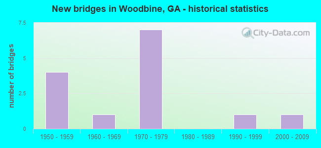
- New bridges - historical statistics
- 41950-1959
- 11960-1969
- 71970-1979
- 11990-1999
- 12000-2009

- Reconstructed bridges - Historical Statistics
- 41990-1999
- 22000-2009


- Bridge Condition - Deck
- 30.8%Very good
- 61.5%Good
- 7.7%Satisfactory

- Bridge Condition - Superstructure
- 7.7%Very good
- 84.6%Good
- 7.7%Satisfactory

- Bridge Condition - Substructure
- 7.7%Very good
- 84.6%Good
- 7.7%Satisfactory

- Bridge Condition - Channel
- 63.6%Very good
- 36.4%Good
Find on map >> Show street view
Structure Number: 390005, Location: 1 MI S OF WOODBINE (Lat: 30.930908, Lng: -81.716119), Route carried "on" structure: US 17, Year Built: 1950, Status: Open, Structure Length: 3.66m (12.01ft), Average Daily Traffic: 2,730 (year 2012), Truck Traffic: 1%, Average Future Daily Traffic: 4,095 (year 2032), Design Load: HS 20, Features Intersected: WALKER SWAMP
Minimum Vertical Clearance: 30+ m (98+ ft), Kilometerpoint: 20.921, Lanes on structure: 2, Base Highway Network: Yes, Owner: State Highway Agency, Approaching Roadway Width: 9.1m (29.9ft), Material/Design: Concrete, Design/Construction: Tee Beam, Number Of Spans In Main Unit: 4, Length of Maximum Span: 9.1m (29.9ft), Curb or Sidewalk Widths: Left: 0.6m (2.0ft), Right: 0.6m (2.0ft), Curb-To-Curb Width: 9.1m (29.9ft), Out-to-Out Width: 11.0m (36.1ft)
Condition: Deck: Very good, Superstructure: Good, Substructure: Good, Channel: Very good, Operating Rating: 37.1 metric tons, Method Used To Determine Operating Rating: Load Factor (LF), Inventory Rating: 22.6 metric tons, Method Used To Determine Inventory Rating: Load Factor (LF), Structural Evaluation: Equal to present minimum criteria, Deck Geometry: Meets minimum limits, Waterway Adequacy: Equal to present desirable criteria, Approach Roadway Alignment: Equal to present desirable criteria, Designated Inspection Frequency: Every 24 months, Inspection Date: June 2021, Bridge Improvement Cost: $469,000, Roadway Improvement Cost: $47,000, Total Project Cost: $703,000, Deck Structure Type: Concrete Cast-file-Place, Wearing Surface/Protective System: Wearing Surface: Epoxy Overlay
Find on map >> Show street view
Structure Number: 390006, Location: IN WOODBINE CITY LIMITS (Lat: 30.974858, Lng: -81.725739), Route carried "on" structure: US 17, Year Built: 1955, Status: Open, Structure Length: 62.85m (206.20ft), Average Daily Traffic: 2,370 (year 2012), Truck Traffic: 1%, Average Future Daily Traffic: 3,555 (year 2032), Design Load: HS 20+Mod, Features Intersected: SATILLA RIVER
Minimum Vertical Clearance: 30+ m (98+ ft), Kilometerpoint: 25.750, Lanes on structure: 2, Base Highway Network: Yes, Owner: State Highway Agency, Approaching Roadway Width: 8.5m (27.9ft), Material/Design: Steel continuous, Design/Construction: Girder and Floorbeam System, Number Of Spans In Main Unit: 4, Number Of Approach Spans: 19, Length of Maximum Span: 46.9m (153.9ft), Curb or Sidewalk Widths: Left: 0.6m (2.0ft), Right: 0.6m (2.0ft), Curb-To-Curb Width: 8.5m (27.9ft), Out-to-Out Width: 10.4m (34.1ft)
Condition: Deck: Satisfactory, Superstructure: Satisfactory, Substructure: Satisfactory, Channel: Good, Operating Rating: 40.8 metric tons, Method Used To Determine Operating Rating: Load Factor (LF), Inventory Rating: 24.4 metric tons, Method Used To Determine Inventory Rating: Load Factor (LF), Structural Evaluation: Equal to present minimum criteria, Deck Geometry: Meets minimum limits, Waterway Adequacy: Equal to present desirable criteria, Approach Roadway Alignment: Equal to present desirable criteria, Length Of Structure Improvement: 68.67m (225.30ft), Designated Inspection Frequency: Every 24 months, Critical Feature Inspection Frequency: Every 12 months, Underwater Inspection Frequency: Every 60 months, Inspection Date: January 2021, Critical Feature Inspection Date: January 2022, Underwater Inspection Date: September 2018, Bridge Improvement Cost: $8,057,000, Roadway Improvement Cost: $806,000, Total Project Cost: $12,085,000, Deck Structure Type: Concrete Cast-file-Place
Find on map >> Show street view
Structure Number: 390007, Location: 2 MI N OF WOODBINE (Lat: 30.998139, Lng: -81.731019), Route carried "on" structure: US 17, Year Built: 1955, Status: Open, Structure Length: 3.02m (9.91ft), Average Daily Traffic: 1,380 (year 2012), Truck Traffic: 1%, Average Future Daily Traffic: 2,070 (year 2032), Design Load: HS 20+Mod, Features Intersected: TOWER SWAMP
Minimum Vertical Clearance: 30+ m (98+ ft), Kilometerpoint: 28.968, Lanes on structure: 2, Base Highway Network: Yes, Owner: State Highway Agency, Approaching Roadway Width: 8.5m (27.9ft), Material/Design: Concrete, Design/Construction: Tee Beam, Number Of Spans In Main Unit: 3, Length of Maximum Span: 10.1m (33.1ft), Curb or Sidewalk Widths: Left: 0.6m (2.0ft), Right: 0.6m (2.0ft), Curb-To-Curb Width: 8.5m (27.9ft), Out-to-Out Width: 10.4m (34.1ft)
Condition: Deck: Very good, Superstructure: Good, Substructure: Good, Channel: Good, Operating Rating: 36.2 metric tons, Method Used To Determine Operating Rating: Load Factor (LF), Inventory Rating: 21.7 metric tons, Method Used To Determine Inventory Rating: Load Factor (LF), Structural Evaluation: Somewhat better than minimum adequacy, Deck Geometry: Somewhat better than minimum adequacy, Waterway Adequacy: Equal to present desirable criteria, Approach Roadway Alignment: Equal to present desirable criteria, Designated Inspection Frequency: Every 24 months, Inspection Date: April 2021, Bridge Improvement Cost: $387,000, Roadway Improvement Cost: $39,000, Total Project Cost: $580,000, Deck Structure Type: Concrete Cast-file-Place, Wearing Surface/Protective System: Wearing Surface: Epoxy Overlay
Find on map >> Show street view
Structure Number: 390012, Location: 2 MI E OF WOODBINE (Lat: 30.945900, Lng: -81.686458), Route carried "on" structure: Spur State highway 25, Year Built: 1972, Year Reconstructed: 2000, Status: Open, Structure Length: 7.89m (25.89ft), Average Daily Traffic: 2,980 (year 2012), Truck Traffic: 1%, Average Future Daily Traffic: 4,470 (year 2032), Design Load: HS 20+Mod, Features Intersected: I-95 (SR 405)
Minimum Vertical Clearance: 30+ m (98+ ft), Kilometerpoint: 4.828, Lanes on structure: 2, Lanes under structure: 6, Base Highway Network: Yes, Owner: State Highway Agency, Approaching Roadway Width: 12.5m (41.0ft), Material/Design: Steel continuous, Design/Construction: Stringer/Multi-beam, Number Of Spans In Main Unit: 4, Length of Maximum Span: 27.4m (89.9ft), Curb-To-Curb Width: 13.0m (42.7ft), Out-to-Out Width: 14.1m (46.3ft)
Condition: Deck: Good, Superstructure: Good, Substructure: Good, Operating Rating: 45.3 metric tons, Method Used To Determine Operating Rating: Load Factor (LF), Inventory Rating: 27.2 metric tons, Method Used To Determine Inventory Rating: Load Factor (LF), Structural Evaluation: Equal to present minimum criteria, Deck Geometry: Equal to present minimum criteria, Underclear: Better than present minimum criteria, Approach Roadway Alignment: Equal to present desirable criteria, Designated Inspection Frequency: Every 24 months, Inspection Date: June 2021, Bridge Improvement Cost: $1,012,000, Roadway Improvement Cost: $101,000, Total Project Cost: $1,518,000, Deck Structure Type: Concrete Cast-file-Place
Find on map >> Show street view
Structure Number: 390021, Location: 3 MI SE OF WOODBINE (Lat: 30.925858, Lng: -81.686197), Route carried "on" structure: County highway 94, Year Built: 1972, Year Reconstructed: 2000, Status: Open, Structure Length: 12.31m (40.39ft), Average Daily Traffic: 490 (year 2012), Truck Traffic: 1%, Average Future Daily Traffic: 735 (year 2032), Design Load: HS 15, Features Intersected: I-95 (SR 405), Facility Carried by Structure: BILLYVILLE ROAD
Minimum Vertical Clearance: 30+ m (98+ ft), Kilometerpoint: 4.828, Lanes on structure: 2, Lanes under structure: 6, Base Highway Network: Yes, Owner: State Highway Agency, Approaching Roadway Width: 6.4m (21.0ft), Skew: 1 degrees, Material/Design: Steel, Design/Construction: Stringer/Multi-beam, Number Of Spans In Main Unit: 6, Length of Maximum Span: 27.4m (89.9ft), Curb-To-Curb Width: 8.8m (28.9ft), Out-to-Out Width: 10.0m (32.8ft)
Condition: Deck: Good, Superstructure: Good, Substructure: Good, Operating Rating: 40.8 metric tons, Method Used To Determine Operating Rating: Allowable Stress (AS), Inventory Rating: 24.4 metric tons, Method Used To Determine Inventory Rating: Allowable Stress (AS), Structural Evaluation: Equal to present minimum criteria, Deck Geometry: Somewhat better than minimum adequacy, Underclear: Better than present minimum criteria, Approach Roadway Alignment: Better than present minimum criteria, Designated Inspection Frequency: Every 24 months, Inspection Date: June 2021, Bridge Improvement Cost: $1,579,000, Roadway Improvement Cost: $158,000, Total Project Cost: $2,368,000, Deck Structure Type: Concrete Cast-file-Place
Find on map >> Show street view
Structure Number: 390024, Location: 2 MI SW OF WOODBINE (Lat: 30.937508, Lng: -81.751028), Route carried "on" structure: State highway 110, Year Built: 1960, Status: Open, Structure Length: 0.64m (2.10ft), Average Daily Traffic: 820 (year 2012), Truck Traffic: 1%, Average Future Daily Traffic: 1,230 (year 2032), Design Load: HS 20+Mod, Features Intersected: WALKER SWAMP
Minimum Vertical Clearance: 30+ m (98+ ft), Kilometerpoint: 19.312, Lanes on structure: 2, Base Highway Network: Yes, Owner: State Highway Agency, Approaching Roadway Width: 8.5m (27.9ft), Material/Design: Concrete, Design/Construction: Culvert, Number Of Spans In Main Unit: 2, Length of Maximum Span: 3.0m (9.8ft)
Condition: Channel: Good, Culverts: Good, Operating Rating: 55.3 metric tons, Method Used To Determine Operating Rating: Load Factor (LF), Inventory Rating: 32.6 metric tons, Method Used To Determine Inventory Rating: Load Factor (LF), Structural Evaluation: Better than present minimum criteria, Waterway Adequacy: Equal to present desirable criteria, Approach Roadway Alignment: Equal to present desirable criteria, Designated Inspection Frequency: Every 24 months, Inspection Date: May 2021, Bridge Improvement Cost: $82,000, Roadway Improvement Cost: $8,000, Total Project Cost: $123,000
Find on map >> Show street view
Structure Number: 390036, Location: 7.5 MI N OF KINGSLAND (Lat: 30.912169, Lng: -81.685850), Route carried "on" structure: Interstate 95, Year Built: 1972, Year Reconstructed: 1999, Status: Open, Structure Length: 2.74m (8.99ft), Average Daily Traffic: 47,410 (year 2012), Truck Traffic: 1%, Average Future Daily Traffic: 71,115 (year 2032), Design Load: HS 20+Mod, Features Intersected: WALKER SWAMP
Minimum Vertical Clearance: 30+ m (98+ ft), Kilometerpoint: 19.312, Lanes on structure: 3, Base Highway Network: Yes, Owner: State Highway Agency, Approaching Roadway Width: 17.7m (58.1ft), Skew: 10 degrees, Material/Design: Concrete, Design/Construction: Tee Beam, Number Of Spans In Main Unit: 3, Length of Maximum Span: 9.1m (29.9ft), Curb-To-Curb Width: 23.3m (76.4ft), Out-to-Out Width: 24.3m (79.7ft)
Condition: Deck: Good, Superstructure: Good, Substructure: Good, Channel: Very good, Operating Rating: 33.5 metric tons, Method Used To Determine Operating Rating: Load Factor (LF), Inventory Rating: 19.9 metric tons, Method Used To Determine Inventory Rating: Load Factor (LF), Structural Evaluation: Somewhat better than minimum adequacy, Deck Geometry: Superior to present desirable criteria, Waterway Adequacy: Equal to present desirable criteria, Approach Roadway Alignment: Equal to present desirable criteria, Designated Inspection Frequency: Every 24 months, Inspection Date: June 2021, Bridge Improvement Cost: $448,000, Roadway Improvement Cost: $45,000, Total Project Cost: $671,000, Deck Structure Type: Concrete Cast-file-Place
Find on map >> Show street view
Structure Number: 390037, Location: 7.5 MI N OF KINGSLAND (Lat: 30.912178, Lng: -81.686447), Route carried "on" structure: Interstate 95, Year Built: 1972, Year Reconstructed: 1999, Status: Open, Structure Length: 2.74m (8.99ft), Average Daily Traffic: 47,410 (year 2012), Truck Traffic: 1%, Average Future Daily Traffic: 71,115 (year 2032), Design Load: HS 20+Mod, Features Intersected: WALKER SWAMP
Minimum Vertical Clearance: 30+ m (98+ ft), Kilometerpoint: 19.312, Lanes on structure: 3, Base Highway Network: Yes, Owner: State Highway Agency, Approaching Roadway Width: 17.7m (58.1ft), Skew: 10 degrees, Material/Design: Concrete, Design/Construction: Tee Beam, Number Of Spans In Main Unit: 3, Length of Maximum Span: 9.1m (29.9ft), Curb-To-Curb Width: 23.3m (76.4ft), Out-to-Out Width: 24.3m (79.7ft)
Condition: Deck: Good, Superstructure: Good, Substructure: Good, Channel: Very good, Operating Rating: 33.5 metric tons, Method Used To Determine Operating Rating: Load Factor (LF), Inventory Rating: 19.9 metric tons, Method Used To Determine Inventory Rating: Load Factor (LF), Structural Evaluation: Somewhat better than minimum adequacy, Deck Geometry: Superior to present desirable criteria, Waterway Adequacy: Equal to present desirable criteria, Approach Roadway Alignment: Equal to present desirable criteria, Designated Inspection Frequency: Every 24 months, Inspection Date: June 2021, Bridge Improvement Cost: $448,000, Roadway Improvement Cost: $45,000, Total Project Cost: $671,000, Deck Structure Type: Concrete Cast-file-Place
Find on map >> Show street view
Structure Number: 390038, Location: 2.25 MI SE OF WOODBINE (Lat: 30.955428, Lng: -81.682539), Route carried "on" structure: Interstate 95, Year Built: 1975, Year Reconstructed: 2001, Status: Open, Structure Length: 48.37m (158.69ft), Average Daily Traffic: 45,240 (year 2012), Truck Traffic: 1%, Average Future Daily Traffic: 67,860 (year 2032), Design Load: HS 20+Mod, Features Intersected: SATILLA RIVER
Minimum Vertical Clearance: 30+ m (98+ ft), Kilometerpoint: 24.140, Lanes on structure: 3, Base Highway Network: Yes, Owner: State Highway Agency, Approaching Roadway Width: 18.3m (60.0ft), Skew: 10 degrees, Navigation Control: Yes ( Vertical Clearance: 13.4m (44.0ft), Horizontal Clearance: 24.3m (79.7ft)), Material/Design: Steel continuous, Design/Construction: Stringer/Multi-beam, Number Of Spans In Main Unit: 3, Number Of Approach Spans: 14, Length of Maximum Span: 46.9m (153.9ft), Curb-To-Curb Width: 23.2m (76.1ft), Out-to-Out Width: 24.1m (79.1ft)
Condition: Deck: Good, Superstructure: Good, Substructure: Good, Channel: Very good, Operating Rating: 45.3 metric tons, Method Used To Determine Operating Rating: Load Factor (LF), Inventory Rating: 20.8 metric tons, Method Used To Determine Inventory Rating: Load Factor (LF), Structural Evaluation: Somewhat better than minimum adequacy, Deck Geometry: Superior to present desirable criteria, Waterway Adequacy: Equal to present desirable criteria, Approach Roadway Alignment: Equal to present desirable criteria, Designated Inspection Frequency: Every 24 months, Underwater Inspection Frequency: Every 60 months, Inspection Date: April 2021, Underwater Inspection Date: September 2018, Bridge Improvement Cost: $7,892,000, Roadway Improvement Cost: $789,000, Total Project Cost: $11,838,000, Deck Structure Type: Concrete Cast-file-Place, Wearing Surface/Protective System: Wearing Surface: Epoxy Overlay
Find on map >> Show street view
Structure Number: 390039, Location: 2.25 MI SE OF WOODBINE (Lat: 30.955539, Lng: -81.682800), Route carried "on" structure: Interstate 95, Year Built: 1975, Year Reconstructed: 2001, Status: Open, Structure Length: 48.37m (158.69ft), Average Daily Traffic: 45,240 (year 2012), Truck Traffic: 1%, Average Future Daily Traffic: 67,860 (year 2032), Design Load: HS 20+Mod, Features Intersected: SATILLA RIVER
Minimum Vertical Clearance: 30+ m (98+ ft), Kilometerpoint: 24.140, Lanes on structure: 3, Base Highway Network: Yes, Owner: State Highway Agency, Approaching Roadway Width: 22.3m (73.2ft), Skew: 10 degrees, Navigation Control: Yes ( Vertical Clearance: 13.4m (44.0ft), Horizontal Clearance: 24.3m (79.7ft)), Material/Design: Steel continuous, Design/Construction: Stringer/Multi-beam, Number Of Spans In Main Unit: 3, Number Of Approach Spans: 14, Length of Maximum Span: 46.9m (153.9ft), Curb-To-Curb Width: 23.2m (76.1ft), Out-to-Out Width: 24.1m (79.1ft)
Condition: Deck: Very good, Superstructure: Good, Substructure: Good, Channel: Very good, Operating Rating: 47.1 metric tons, Method Used To Determine Operating Rating: Load Factor (LF), Inventory Rating: 28.1 metric tons, Method Used To Determine Inventory Rating: Load Factor (LF), Structural Evaluation: Better than present minimum criteria, Deck Geometry: Superior to present desirable criteria, Waterway Adequacy: Equal to present desirable criteria, Approach Roadway Alignment: Equal to present desirable criteria, Designated Inspection Frequency: Every 24 months, Underwater Inspection Frequency: Every 60 months, Inspection Date: April 2021, Underwater Inspection Date: September 2018, Bridge Improvement Cost: $7,892,000, Roadway Improvement Cost: $789,000, Total Project Cost: $11,838,000, Deck Structure Type: Concrete Cast-file-Place, Wearing Surface/Protective System: Wearing Surface: Epoxy Overlay
Find on map >> Show street view
Structure Number: 390053, Location: 2.5 MI E OF SR 25 (Lat: 30.984258, Lng: -81.668828), Route carried "on" structure: ServiceCounty highway 27759, Year Built: 1975, Status: Open, Structure Length: 8.14m (26.71ft), Average Daily Traffic: 50 (year 2012), Truck Traffic: 1%, Average Future Daily Traffic: 75 (year 2032), Design Load: HS 20, Features Intersected: I-95 (SR 405), Facility Carried by Structure: PINE ISLAND ROAD
Minimum Vertical Clearance: 30+ m (98+ ft), Kilometerpoint: 3.219, Lanes on structure: 2, Lanes under structure: 6, Base Highway Network: Yes, Owner: State Highway Agency, Approaching Roadway Width: 5.5m (18.0ft), Skew: 2 degrees, Material/Design: Steel continuous, Design/Construction: Stringer/Multi-beam, Number Of Spans In Main Unit: 4, Length of Maximum Span: 28.0m (91.9ft), Curb-To-Curb Width: 8.9m (29.2ft), Out-to-Out Width: 10.0m (32.8ft)
Condition: Deck: Good, Superstructure: Good, Substructure: Good, Operating Rating: 44.4 metric tons, Method Used To Determine Operating Rating: Allowable Stress (AS), Inventory Rating: 24.4 metric tons, Method Used To Determine Inventory Rating: Allowable Stress (AS), Structural Evaluation: Equal to present minimum criteria, Deck Geometry: Better than present minimum criteria, Underclear: Equal to present minimum criteria, Approach Roadway Alignment: Equal to present desirable criteria, Designated Inspection Frequency: Every 24 months, Inspection Date: June 2021, Bridge Improvement Cost: $1,043,000, Roadway Improvement Cost: $104,000, Total Project Cost: $1,565,000, Deck Structure Type: Concrete Cast-file-Place
Find on map >> Show street view
Structure Number: 395032, Location: 3 MI SW OF WOODBINE (Lat: 30.921989, Lng: -81.735339), Route carried "on" structure: County highway 137, Year Built: 1950, Status: Open, Structure Length: 1.22m (4.00ft), Average Daily Traffic: 490 (year 2012), Truck Traffic: 1%, Average Future Daily Traffic: 735 (year 2032), Design Load: H 15, Features Intersected: WALKER SWAMP, Facility Carried by Structure: COLESBURG-THOMPKIN
Minimum Vertical Clearance: 30+ m (98+ ft), Kilometerpoint: 6.437, Lanes on structure: 2, Base Highway Network: Yes, Owner: County Highway Agency, Approaching Roadway Width: 5.8m (19.0ft), Material/Design: Prestressed concrete, Design/Construction: Channel Beam, Number Of Spans In Main Unit: 2, Length of Maximum Span: 6.1m (20.0ft), Curb-To-Curb Width: 7.3m (24.0ft), Out-to-Out Width: 7.7m (25.3ft)
Condition: Deck: Good, Superstructure: Good, Substructure: Good, Channel: Good, Operating Rating: 39.0 metric tons, Method Used To Determine Operating Rating: Load Factor (LF), Inventory Rating: 23.5 metric tons, Method Used To Determine Inventory Rating: Load Factor (LF), Structural Evaluation: Equal to present minimum criteria, Deck Geometry: Meets minimum limits, Waterway Adequacy: Equal to present desirable criteria, Approach Roadway Alignment: Equal to present desirable criteria, Length Of Structure Improvement: 7.68m (25.20ft), Designated Inspection Frequency: Every 24 months, Inspection Date: June 2021, Bridge Improvement Cost: $156,000, Roadway Improvement Cost: $16,000, Total Project Cost: $234,000, Deck Structure Type: Concrete Precast Panels
Find on map >> Show street view
Structure Number: 395047, Location: CITY LIMIT OF WOODBINE (Lat: 30.966828, Lng: -81.714439), Route carried "on" structure: County highway 96, Year Built: 1995, Status: Open, Structure Length: 1.22m (4.00ft), Average Daily Traffic: 490 (year 2012), Truck Traffic: 1%, Average Future Daily Traffic: 735 (year 2032), Design Load: HS 20+Mod, Features Intersected: DUNN BRANCH, Facility Carried by Structure: BREWSTER AVENUE
Minimum Vertical Clearance: 30+ m (98+ ft), Kilometerpoint: 0.000, Lanes on structure: 2, Base Highway Network: Yes, Owner: County Highway Agency, Approaching Roadway Width: 5.5m (18.0ft), Material/Design: Concrete, Design/Construction: Slab, Number Of Spans In Main Unit: 2, Length of Maximum Span: 6.1m (20.0ft), Curb-To-Curb Width: 7.3m (24.0ft), Out-to-Out Width: 8.2m (26.9ft)
Condition: Deck: Good, Superstructure: Good, Substructure: Good, Channel: Very good, Operating Rating: 48.9 metric tons, Method Used To Determine Operating Rating: Allowable Stress (AS), Inventory Rating: 27.2 metric tons, Method Used To Determine Inventory Rating: Allowable Stress (AS), Structural Evaluation: Equal to present minimum criteria, Deck Geometry: Meets minimum limits, Waterway Adequacy: Equal to present desirable criteria, Approach Roadway Alignment: Equal to present desirable criteria, Designated Inspection Frequency: Every 24 months, Inspection Date: May 2021, Bridge Improvement Cost: $156,000, Roadway Improvement Cost: $16,000, Total Project Cost: $234,000, Deck Structure Type: Concrete Precast Panels
Find on map >> Show street view
Structure Number: 39506, Location: 3 MI SE OF WOODBINE (Lat: 30.925489, Lng: -81.678839), Route carried "on" structure: County highway 94, Year Built: 2003, Status: Open, Structure Length: 1.83m (6.00ft), Average Daily Traffic: 490 (year 2012), Truck Traffic: 1%, Average Future Daily Traffic: 735 (year 2032), Design Load: HS 20+Mod, Features Intersected: LANG CREEK, Facility Carried by Structure: BILLYVILLE ROAD
Minimum Vertical Clearance: 30+ m (98+ ft), Kilometerpoint: 3.219, Lanes on structure: 2, Base Highway Network: Yes, Owner: County Highway Agency, Approaching Roadway Width: 5.5m (18.0ft), Material/Design: Concrete, Design/Construction: Slab, Number Of Spans In Main Unit: 3, Length of Maximum Span: 6.1m (20.0ft), Curb-To-Curb Width: 7.3m (24.0ft), Out-to-Out Width: 8.1m (26.6ft)
Condition: Deck: Very good, Superstructure: Very good, Substructure: Very good, Channel: Very good, Operating Rating: 78.9 metric tons, Method Used To Determine Operating Rating: Allowable Stress (AS), Inventory Rating: 47.1 metric tons, Method Used To Determine Inventory Rating: Allowable Stress (AS), Structural Evaluation: Equal to present desirable criteria, Deck Geometry: Meets minimum limits, Waterway Adequacy: Equal to present desirable criteria, Approach Roadway Alignment: Equal to present desirable criteria, Designated Inspection Frequency: Every 24 months, Inspection Date: June 2021, Bridge Improvement Cost: $234,000, Roadway Improvement Cost: $23,000, Total Project Cost: $352,000, Deck Structure Type: Concrete Precast Panels, Wearing Surface/Protective System: Wearing Surface: Bituminous
Find on map >> Show street view
Structure Number: 390012, Location: 2 MI E OF WOODBINE (Lat: 30.945900, Lng: -81.686458), Route carried "under" structure: Interstate 95, Structure Length: 0. m, Average Daily Traffic: 37,800 (year 1998), Truck Traffic: 1%, Features Intersected: SR 25 SPUR, Facility Carried by Structure: SR 25 SPUR
Minimum Vertical Clearance: 5.53m (18.14ft), Kilometerpoint: 22.531, Lanes on structure: 2, Length of Maximum Span: 0.0m
Find on map >> Show street view
Structure Number: 390021, Location: 3 MI SE OF WOODBINE (Lat: 30.925858, Lng: -81.686197), Route carried "under" structure: Interstate 95, Structure Length: 0. m, Average Daily Traffic: 40,320 (year 1998), Truck Traffic: 1%, Features Intersected: CR 94 BILLYVILLE ROAD, Facility Carried by Structure: BILLYVILLE ROAD
Minimum Vertical Clearance: 5.25m (17.22ft), Kilometerpoint: 20.921, Lanes on structure: 2, Length of Maximum Span: 0.0m
Find on map >> Show street view
Structure Number: 390053, Location: 2.5 MI E OF SR 25 (Lat: 30.984258, Lng: -81.668828), Route carried "under" structure: Interstate 95, Structure Length: 0. m, Average Daily Traffic: 37,800 (year 1998), Truck Traffic: 1%, Features Intersected: CR 27759 PINE ISLAND RD, Facility Carried by Structure: PINE ISLAND ROAD
Minimum Vertical Clearance: 5.18m (16.99ft), Kilometerpoint: 27.359, Lanes on structure: 2, Length of Maximum Span: 0.0m