Bridge Statistics for Wyndham, Virginia (VA)
Condition, Traffic, Stress, Structural Evaluation, Project Costs
- National Bridge Inventory (NBI) Statistics
- 10Number of bridges
- 92ft / 27.6mTotal length
- $2,371,000Total costs
- 29,001Total average daily traffic
- 763Total average daily truck traffic
- 36,744Total future (year 2037) average daily traffic
- National Bridge Inventory (NBI) Registered Bridges for Wyndham
- No street view available for this location
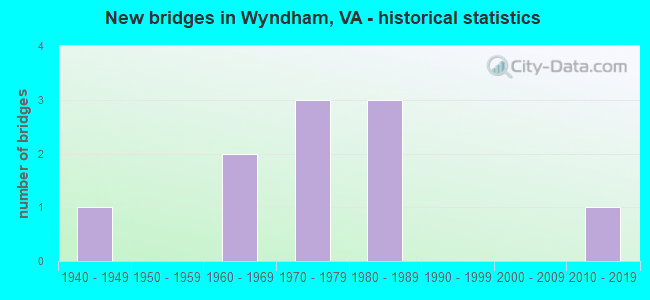
- New bridges - historical statistics
- 11940-1949
- 21960-1969
- 31970-1979
- 31980-1989
- 12010-2019


- Bridge Condition - Deck
- 57.1%Good
- 14.3%Satisfactory
- 28.6%Fair

- Bridge Condition - Superstructure
- 14.3%Very good
- 42.9%Good
- 14.3%Satisfactory
- 28.6%Fair

- Bridge Condition - Substructure
- 14.3%Very good
- 28.6%Good
- 28.6%Satisfactory
- 28.6%Fair

- Bridge Condition - Channel
- 20.0%Very good
- 10.0%Good
- 40.0%Satisfactory
- 20.0%Fair
- 10.0%Poor

- Bridge Condition - Culverts
- 66.7%Satisfactory
- 33.3%Fair
Find on map >> Show street view
Structure Number: 3674, Location: .8 FR 643 & .7 TO 614 (Lat: 36.885303, Lng: -77.865969), Route carried "on" structure: County highway 628, Year Built: 1989, Status: Open, Structure Length: 1.91m (6.27ft), Average Daily Traffic: 254 (year 2016), Average Future Daily Traffic: 284 (year 2040), Design Load: HS 20+Mod, Features Intersected: STURGEON CREEK, Facility Carried by Structure: LITTLEMONT ROAD
Minimum Vertical Clearance: 30+ m (98+ ft), Kilometerpoint: 19.033, Lanes on structure: 2, Owner: State Highway Agency, Approaching Roadway Width: 7.3m (24.0ft), Material/Design: Steel, Design/Construction: Stringer/Multi-beam, Number Of Spans In Main Unit: 1, Length of Maximum Span: 18.3m (60.0ft), Curb or Sidewalk Widths: Left: 0.5m (1.6ft), Right: 0.5m (1.6ft), Curb-To-Curb Width: 7.5m (24.6ft), Out-to-Out Width: 8.5m (27.9ft)
Condition: Deck: Good, Superstructure: Very good, Substructure: Very good, Channel: Very good, Operating Rating: 86.3 metric tons, Method Used To Determine Operating Rating: Load and Resistance Factor (LRFR), Inventory Rating: 66.6 metric tons, Method Used To Determine Inventory Rating: Load and Resistance Factor (LRFR), Structural Evaluation: Equal to present desirable criteria, Deck Geometry: Somewhat better than minimum adequacy, Waterway Adequacy: Equal to present desirable criteria, Approach Roadway Alignment: Equal to present desirable criteria, Length Of Structure Improvement: 1.92m (6.30ft), Designated Inspection Frequency: Every 24 months, Inspection Date: October 2021, Bridge Improvement Cost: $63,000, Roadway Improvement Cost: $15,000, Total Project Cost: $79,000, Deck Structure Type: Concrete Cast-file-Place, Wearing Surface/Protective System: Deck Protection: Epoxy Coated Reinforcing
Find on map >> Show street view
Structure Number: 3675, Location: 1.68 FR 636 & 1.2 TO 643 (Lat: 36.921742, Lng: -77.872392), Route carried "on" structure: County highway 628, Year Built: 1987, Status: Open, Structure Length: 2.59m (8.50ft), Average Daily Traffic: 158 (year 2016), Average Future Daily Traffic: 177 (year 2040), Design Load: HS 20+Mod, Features Intersected: WAQUA CREEK, Facility Carried by Structure: RED OAK ROAD
Minimum Vertical Clearance: 30+ m (98+ ft), Kilometerpoint: 14.520, Lanes on structure: 2, Owner: State Highway Agency, Approaching Roadway Width: 8.5m (27.9ft), Skew: 3 degrees, Material/Design: Steel, Design/Construction: Stringer/Multi-beam, Number Of Spans In Main Unit: 1, Length of Maximum Span: 25.9m (85.0ft), Curb or Sidewalk Widths: Left: 0.5m (1.6ft), Right: 0.5m (1.6ft), Curb-To-Curb Width: 7.9m (25.9ft), Out-to-Out Width: 8.9m (29.2ft)
Condition: Deck: Good, Superstructure: Good, Substructure: Good, Channel: Very good, Operating Rating: 80.7 metric tons, Method Used To Determine Operating Rating: Load and Resistance Factor (LRFR), Inventory Rating: 61.7 metric tons, Method Used To Determine Inventory Rating: Load and Resistance Factor (LRFR), Structural Evaluation: Better than present minimum criteria, Deck Geometry: Somewhat better than minimum adequacy, Waterway Adequacy: Equal to present desirable criteria, Approach Roadway Alignment: Equal to present desirable criteria, Length Of Structure Improvement: 2.68m (8.79ft), Designated Inspection Frequency: Every 24 months, Inspection Date: October 2021, Bridge Improvement Cost: $80,000, Roadway Improvement Cost: $20,000, Total Project Cost: $111,000, Deck Structure Type: Concrete Cast-file-Place, Wearing Surface/Protective System: Deck Protection: Epoxy Coated Reinforcing
Find on map >> Show street view
Structure Number: 3676, Location: 2.95FR 616W & .95 TO 706 (Lat: 36.969564, Lng: -77.893189), Route carried "on" structure: County highway 628, Year Built: 1963, Status: Posted for load, Structure Length: 1.25m (4.10ft), Average Daily Traffic: 35 (year 2013), Average Future Daily Traffic: 40 (year 2040), Features Intersected: RED OAK CREEK, Facility Carried by Structure: JUDD ROAD
Minimum Vertical Clearance: 30+ m (98+ ft), Kilometerpoint: 4.735, Lanes on structure: 1, Owner: State Highway Agency, Approaching Roadway Width: 4.6m (15.1ft), Material/Design: Steel, Design/Construction: Stringer/Multi-beam, Number Of Spans In Main Unit: 1, Length of Maximum Span: 11.9m (39.0ft), Curb or Sidewalk Widths: Left: 0.1m (0.3ft), Right: 0.1m (0.3ft), Curb-To-Curb Width: 4.1m (13.5ft), Out-to-Out Width: 4.4m (14.4ft)
Condition: Deck: Fair, Superstructure: Satisfactory, Substructure: Fair, Channel: Good, Operating Rating: 10.9 metric tons, Method Used To Determine Operating Rating: Field evaluation and documented engineering judgment, Inventory Rating: 6.4 metric tons, Method Used To Determine Inventory Rating: Field evaluation and documented engineering judgment, Structural Evaluation: High priority of corrective action, Deck Geometry: Somewhat better than minimum adequacy, Waterway Adequacy: Somewhat better than minimum adequacy, Approach Roadway Alignment: Somewhat better than minimum adequacy, Bridge Posting: Required (Relationship of Operating Rating to Maximum Legal Load: > 39.9% below), Length Of Structure Improvement: 1.28m (4.20ft), Designated Inspection Frequency: Every 12 months, Inspection Date: October 2021, Bridge Improvement Cost: $86,000, Roadway Improvement Cost: $25,000, Total Project Cost: $151,000 ( Estimate for 2015), Deck Structure Type: Wood or Timber, Wearing Surface/Protective System: Wearing Surface: Bituminous
Find on map >> Show street view
Structure Number: 368, Location: 1.1 FR 635 & .4 TO 682 (Lat: 36.848192, Lng: -77.784375), Route carried "on" structure: County highway 630, Year Built: 1971, Status: Posted for load, Structure Length: 1.63m (5.35ft), Average Daily Traffic: 233 (year 2020), Truck Traffic: 7%, Average Future Daily Traffic: 256 (year 2040), Design Load: HS 20, Features Intersected: LLOYDS CREEK, Facility Carried by Structure: STURGEON ROAD
Minimum Vertical Clearance: 30+ m (98+ ft), Kilometerpoint: 5.455, Lanes on structure: 2, Owner: State Highway Agency, Approaching Roadway Width: 7.3m (24.0ft), Material/Design: Steel, Design/Construction: Stringer/Multi-beam, Number Of Spans In Main Unit: 1, Length of Maximum Span: 15.8m (51.8ft), Curb or Sidewalk Widths: Left: 0.2m (0.7ft), Right: 0.2m (0.7ft), Curb-To-Curb Width: 7.1m (23.3ft), Out-to-Out Width: 7.3m (24.0ft)
Condition: Deck: Good, Superstructure: Good, Substructure: Satisfactory, Channel: Satisfactory, Operating Rating: 33.5 metric tons, Method Used To Determine Operating Rating: Load and Resistance Factor (LRFR), Inventory Rating: 25.9 metric tons, Method Used To Determine Inventory Rating: Load and Resistance Factor (LRFR), Structural Evaluation: Equal to present minimum criteria, Deck Geometry: Meets minimum limits, Waterway Adequacy: Somewhat better than minimum adequacy, Approach Roadway Alignment: Equal to present minimum criteria, Length Of Structure Improvement: 2.07m (6.79ft), Designated Inspection Frequency: Every 24 months, Inspection Date: January 2021, Bridge Improvement Cost: $810,000, Roadway Improvement Cost: $200,000, Total Project Cost: $1,130,000 ( Estimate for 2017), Deck Structure Type: Wood or Timber, Wearing Surface/Protective System: Wearing Surface: Bituminous
Find on map >> Show street view
Structure Number: 9379, Location: 1.05 TO 670 &0.67 TO 671 (Lat: 37.760011, Lng: -77.612497), Route carried "on" structure: US 33, Year Built: 1970, Status: Open, Structure Length: 5.49m (18.01ft), Average Daily Traffic: 9,416 (year 2020), Truck Traffic: 3%, Average Future Daily Traffic: 13,182 (year 2040), Design Load: HS 20+Mod, Features Intersected: SOUTH ANNA RIVER, Facility Carried by Structure: MOUNTAIN ROAD
Minimum Vertical Clearance: 30+ m (98+ ft), Kilometerpoint: 189.325, Lanes on structure: 2, Base Highway Network: Yes, Owner: State Highway Agency, Approaching Roadway Width: 13.1m (43.0ft), Skew: 1 degrees, Material/Design: Concrete continuous, Design/Construction: Slab, Number Of Spans In Main Unit: 4, Length of Maximum Span: 15.2m (49.9ft), Curb-To-Curb Width: 12.8m (42.0ft), Out-to-Out Width: 14.0m (45.9ft)
Condition: Deck: Fair, Superstructure: Fair, Substructure: Satisfactory, Channel: Satisfactory, Operating Rating: 52.5 metric tons, Method Used To Determine Operating Rating: Load and Resistance Factor (LRFR), Inventory Rating: 40.5 metric tons, Method Used To Determine Inventory Rating: Load and Resistance Factor (LRFR), Structural Evaluation: Somewhat better than minimum adequacy, Deck Geometry: Somewhat better than minimum adequacy, Waterway Adequacy: Equal to present desirable criteria, Approach Roadway Alignment: Equal to present desirable criteria, Length Of Structure Improvement: 5.49m (18.01ft), Designated Inspection Frequency: Every 24 months, Inspection Date: Febuary 2022, Bridge Improvement Cost: $800,000, Roadway Improvement Cost: $20,000, Total Project Cost: $900,000, Deck Structure Type: Concrete Cast-file-Place
Find on map >> Show street view
Structure Number: 9498, Location: 2.5 TO 623 & .02 HENRICO (Lat: 37.695511, Lng: -77.592081), Route carried "on" structure: County highway 624, Year Built: 1972, Status: Open, Structure Length: 0.94m (3.08ft), Average Daily Traffic: 2,486 (year 2020), Average Future Daily Traffic: 3,480 (year 2040), Design Load: HS 20, Features Intersected: CHICKAHOMINY RIVER, Facility Carried by Structure: CAUTHORNE ROAD
Minimum Vertical Clearance: 30+ m (98+ ft), Kilometerpoint: 7.731, Lanes on structure: 2, Owner: State Highway Agency, Approaching Roadway Width: 8.5m (27.9ft), Material/Design: Concrete, Design/Construction: Culvert, Number Of Spans In Main Unit: 3, Length of Maximum Span: 3.0m (9.8ft)
Condition: Channel: Fair, Culverts: Satisfactory, Operating Rating: 54.4 metric tons, Method Used To Determine Operating Rating: Field evaluation and documented engineering judgment, Inventory Rating: 32.7 metric tons, Method Used To Determine Inventory Rating: Field evaluation and documented engineering judgment, Structural Evaluation: Equal to present minimum criteria, Waterway Adequacy: Better than present minimum criteria, Approach Roadway Alignment: Better than present minimum criteria, Designated Inspection Frequency: Every 24 months, Inspection Date: Febuary 2021
Find on map >> Show street view
Structure Number: 9556, Location: 0.25 TO 703 & 0.85 TO 611 (Lat: 37.747592, Lng: -77.653964), Route carried "on" structure: County highway 673, Year Built: 1968, Status: Open, Structure Length: 7.09m (23.26ft), Average Daily Traffic: 2,435 (year 2020), Truck Traffic: 1%, Average Future Daily Traffic: 2,905 (year 2040), Design Load: HS 20+Mod, Features Intersected: SOUTH ANNA RIVER, Facility Carried by Structure: HOWARDS MILL ROAD
Minimum Vertical Clearance: 30+ m (98+ ft), Kilometerpoint: 4.586, Lanes on structure: 2, Owner: State Highway Agency, Approaching Roadway Width: 6.9m (22.6ft), Skew: 3 degrees, Material/Design: Steel, Design/Construction: Stringer/Multi-beam, Number Of Spans In Main Unit: 4, Length of Maximum Span: 17.2m (56.4ft), Curb or Sidewalk Widths: Left: 0.2m (0.7ft), Right: 0.2m (0.7ft), Curb-To-Curb Width: 8.1m (26.6ft), Out-to-Out Width: 9.1m (29.9ft)
Condition: Deck: Satisfactory, Superstructure: Fair, Substructure: Fair, Channel: Satisfactory, Operating Rating: 66.2 metric tons, Method Used To Determine Operating Rating: Load and Resistance Factor (LRFR), Inventory Rating: 50.8 metric tons, Method Used To Determine Inventory Rating: Load and Resistance Factor (LRFR), Structural Evaluation: Somewhat better than minimum adequacy, Deck Geometry: High priority of corrective action, Waterway Adequacy: Equal to present desirable criteria, Approach Roadway Alignment: Equal to present minimum criteria, Designated Inspection Frequency: Every 24 months, Inspection Date: May 2020, Deck Structure Type: Concrete Cast-file-Place
Find on map >> Show street view
Structure Number: 9558, Location: 0.90 TO 611 & 1.0 TO 670 (Lat: 37.752425, Lng: -77.631592), Route carried "on" structure: County highway 675, Year Built: 1986, Status: Open, Structure Length: 5.41m (17.75ft), Average Daily Traffic: 418 (year 2020), Average Future Daily Traffic: 585 (year 2040), Design Load: HS 20+Mod, Features Intersected: SOUTH ANNA RIVER, Facility Carried by Structure: AUBURN MILL ROAD
Minimum Vertical Clearance: 30+ m (98+ ft), Kilometerpoint: 1.609, Lanes on structure: 2, Owner: State Highway Agency, Approaching Roadway Width: 7.9m (25.9ft), Material/Design: Steel, Design/Construction: Stringer/Multi-beam, Number Of Spans In Main Unit: 3, Length of Maximum Span: 25.5m (83.7ft), Curb-To-Curb Width: 7.3m (24.0ft), Out-to-Out Width: 8.3m (27.2ft)
Condition: Deck: Good, Superstructure: Good, Substructure: Good, Channel: Satisfactory, Operating Rating: 78.9 metric tons, Method Used To Determine Operating Rating: Load and Resistance Factor (LRFR), Inventory Rating: 60.8 metric tons, Method Used To Determine Inventory Rating: Load and Resistance Factor (LRFR), Structural Evaluation: Better than present minimum criteria, Deck Geometry: Meets minimum limits, Waterway Adequacy: Equal to present desirable criteria, Approach Roadway Alignment: Equal to present desirable criteria, Designated Inspection Frequency: Every 24 months, Inspection Date: April 2021, Deck Structure Type: Concrete Cast-file-Place, Wearing Surface/Protective System: Deck Protection: Epoxy Coated Reinforcing
Find on map >> Show street view
Structure Number: 12647, Location: 0.16 TO 629 & 0.06 T0 628 (Lat: 37.429172, Lng: -76.987508), Route carried "on" structure: US 60, Year Built: 1948, Status: Open, Structure Length: 0.64m (2.10ft), Average Daily Traffic: 4,266 (year 2020), Truck Traffic: 6%, Average Future Daily Traffic: 4,821 (year 2040), Design Load: HS 20, Features Intersected: WINDSOR SHADES CREEK, Facility Carried by Structure: POCAHONTAS TRAIL
Minimum Vertical Clearance: 30+ m (98+ ft), Kilometerpoint: 350.918, Lanes on structure: 4, Base Highway Network: Yes, Owner: State Highway Agency, Approaching Roadway Width: 14.6m (47.9ft), Skew: 20 degrees, Material/Design: Concrete, Design/Construction: Culvert, Number Of Spans In Main Unit: 2, Length of Maximum Span: 3.0m (9.8ft)
Condition: Channel: Poor, Culverts: Fair, Operating Rating: 54.4 metric tons, Method Used To Determine Operating Rating: Field evaluation and documented engineering judgment, Inventory Rating: 32.7 metric tons, Method Used To Determine Inventory Rating: Field evaluation and documented engineering judgment, Structural Evaluation: Somewhat better than minimum adequacy, Waterway Adequacy: Better than present minimum criteria, Approach Roadway Alignment: Equal to present desirable criteria, Designated Inspection Frequency: Every 24 months, Inspection Date: December 2020
Find on map >> Show street view
Structure Number: 30653, Location: .05 ASHDOWN OAKS COURT (Lat: 37.685000, Lng: -77.608333), Route carried "on" structure: County highway , Year Built: 2015, Status: Posted for load, Structure Length: 0.67m (2.20ft), Average Daily Traffic: 9,300 (year 2020), Truck Traffic: 2%, Average Future Daily Traffic: 11,014 (year 2037), Design Load: HS 20+Mod, Features Intersected: UNNAMED TRIBUTARY, Facility Carried by Structure: GREY OAKS PARK DR
Minimum Vertical Clearance: 30.45m (99.90ft), Kilometerpoint: 0.000, Lanes on structure: 2, Owner: County Highway Agency, Approaching Roadway Width: 12.5m (41.0ft), Skew: 2 degrees, Material/Design: Concrete, Design/Construction: Culvert, Number Of Spans In Main Unit: 2, Length of Maximum Span: 2.7m (8.9ft), Curb or Sidewalk Widths: Left: 0.0m, Right: 1.5m (4.9ft)
Condition: Channel: Fair, Culverts: Satisfactory, Operating Rating: 54.4 metric tons, Method Used To Determine Operating Rating: Load and Resistance Factor (LRFR), Inventory Rating: 32.7 metric tons, Method Used To Determine Inventory Rating: Load and Resistance Factor (LRFR), Structural Evaluation: Equal to present minimum criteria, Waterway Adequacy: Equal to present desirable criteria, Approach Roadway Alignment: Equal to present desirable criteria, Designated Inspection Frequency: Every 24 months, Inspection Date: August 2021