Bridge Statistics for Yardley, Pennsylvania (PA)
Condition, Traffic, Stress, Structural Evaluation, Project Costs
- National Bridge Inventory (NBI) Statistics
- 24Number of bridges
- 554ft / 169mTotal length
- $4,033,000Total costs
- 217,648Total average daily traffic
- 13,402Total average daily truck traffic
- National Bridge Inventory (NBI) Registered Bridges for Yardley
- No street view available for this location
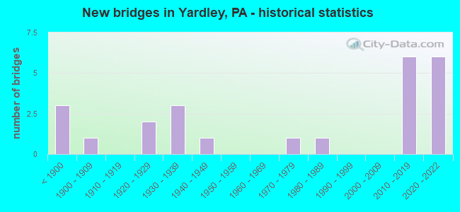
- New bridges - historical statistics
- 3Before 1900
- 11900-1909
- 21920-1929
- 31930-1939
- 11940-1949
- 11970-1979
- 11980-1989
- 62010-2019
- 62020-2022

- Reconstructed bridges - Historical Statistics
- 21980-1989
- 31990-1999
- 02000-2009
- 12010-2019


- Bridge Condition - Deck
- 16.7%Excellent
- 5.6%Very good
- 33.3%Good
- 27.8%Satisfactory
- 16.7%Fair

- Bridge Condition - Superstructure
- 33.3%Excellent
- 16.7%Good
- 5.6%Satisfactory
- 38.9%Fair
- 5.6%Failed

- Bridge Condition - Substructure
- 16.7%Excellent
- 16.7%Very good
- 5.6%Good
- 22.2%Satisfactory
- 22.2%Fair
- 16.7%Poor

- Bridge Condition - Channel
- 18.8%Very good
- 37.5%Good
- 6.3%Satisfactory
- 37.5%Poor
Find on map >> Show street view
Structure Number: 6784, Location: YARDLEY BOROUGH 33D11 (Lat: 40.245194, Lng: -74.836950), Route carried "on" structure: State highway 32, Year Built: 1932, Year Reconstructed: 1980, Status: Open, Structure Length: 2.10m (6.89ft), Average Daily Traffic: 3,876 (year 2021), Truck Traffic: 5%, Average Future Daily Traffic: 4,519 (year 2032), Design Load: HS 20, Features Intersected: BUCK CREEK, Facility Carried by Structure: RIVER ROAD
Minimum Vertical Clearance: 30+ m (98+ ft), Kilometerpoint: 9.159, Lanes on structure: 2, Base Highway Network: Yes, Owner: State Highway Agency, Approaching Roadway Width: 7.0m (23.0ft), Material/Design: Steel, Design/Construction: Stringer/Multi-beam, Number Of Spans In Main Unit: 1, Length of Maximum Span: 20.4m (66.9ft), Curb-To-Curb Width: 6.7m (22.0ft), Out-to-Out Width: 7.8m (25.6ft)
Condition: Deck: Good, Superstructure: Fair, Substructure: Poor, Channel: Poor, Operating Rating: 68.9 metric tons, Method Used To Determine Operating Rating: Load Factor (LF), Inventory Rating: 40.8 metric tons, Method Used To Determine Inventory Rating: Load Factor (LF), Structural Evaluation: Meets minimum limits, Deck Geometry: High priority of replacement, Waterway Adequacy: Equal to present minimum criteria, Approach Roadway Alignment: Better than present minimum criteria, Length Of Structure Improvement: 2.80m (9.19ft), Designated Inspection Frequency: Every 24 months, Inspection Date: July 2021, Bridge Improvement Cost: $60,000, Roadway Improvement Cost: $175,000, Total Project Cost: $804,000, Deck Structure Type: Concrete Cast-file-Place, Wearing Surface/Protective System: Wearing Surface: Monolithic Concrete, Deck Protection: Epoxy Coated Reinforcing
Find on map >> Show street view
Structure Number: 6785, Location: NORTH OF YARDLEY 33C09 (Lat: 40.255739, Lng: -74.847981), Route carried "on" structure: State highway 32, Year Built: 1928, Status: Open, Structure Length: 1.52m (4.99ft), Average Daily Traffic: 3,876 (year 2021), Truck Traffic: 5%, Average Future Daily Traffic: 4,519 (year 2032), Design Load: H 15, Features Intersected: TRIB DELAWARE RIVER, Facility Carried by Structure: RIVER ROAD
Minimum Vertical Clearance: 30+ m (98+ ft), Kilometerpoint: 10.760, Lanes on structure: 2, Base Highway Network: Yes, Owner: State Highway Agency, Approaching Roadway Width: 6.7m (22.0ft), Skew: 4 degrees, Material/Design: Concrete, Design/Construction: Tee Beam, Number Of Spans In Main Unit: 1, Length of Maximum Span: 14.6m (47.9ft), Curb-To-Curb Width: 7.2m (23.6ft), Out-to-Out Width: 7.9m (25.9ft)
Condition: Deck: Fair, Superstructure: Fair, Substructure: Fair, Channel: Poor, Operating Rating: 49.9 metric tons, Method Used To Determine Operating Rating: Load Factor (LF), Inventory Rating: 29.9 metric tons, Method Used To Determine Inventory Rating: Load Factor (LF), Structural Evaluation: Somewhat better than minimum adequacy, Deck Geometry: High priority of replacement, Waterway Adequacy: Equal to present minimum criteria, Approach Roadway Alignment: Better than present minimum criteria, Length Of Structure Improvement: 1.80m (5.91ft), Designated Inspection Frequency: Every 24 months, Inspection Date: June 2021, Bridge Improvement Cost: $38,000, Roadway Improvement Cost: $112,000, Total Project Cost: $513,000, Deck Structure Type: Concrete Cast-file-Place, Wearing Surface/Protective System: Wearing Surface: Bituminous
Find on map >> Show street view
Structure Number: 6786, Location: 2MI.N.OF TR-332 33A07 (Lat: 40.267644, Lng: -74.856456), Route carried "on" structure: State highway 32, Year Built: 1929, Status: Open, Structure Length: 0.70m (2.30ft), Average Daily Traffic: 3,876 (year 2021), Truck Traffic: 5%, Average Future Daily Traffic: 4,519 (year 2032), Design Load: H 15, Features Intersected: DYERS CREEK, Facility Carried by Structure: RIVER ROAD
Minimum Vertical Clearance: 30+ m (98+ ft), Kilometerpoint: 11.990, Lanes on structure: 2, Base Highway Network: Yes, Owner: State Highway Agency, Approaching Roadway Width: 7.0m (23.0ft), Material/Design: Steel, Design/Construction: Stringer/Multi-beam, Number Of Spans In Main Unit: 1, Length of Maximum Span: 6.1m (20.0ft), Curb or Sidewalk Widths: Left: 1.6m (5.2ft), Right: 0.0m, Curb-To-Curb Width: 7.7m (25.3ft), Out-to-Out Width: 9.9m (32.5ft)
Condition: Deck: Satisfactory, Superstructure: Fair, Substructure: Fair, Channel: Poor, Operating Rating: 78.0 metric tons, Method Used To Determine Operating Rating: Load Factor (LF), Inventory Rating: 46.3 metric tons, Method Used To Determine Inventory Rating: Load Factor (LF), Structural Evaluation: Somewhat better than minimum adequacy, Deck Geometry: High priority of replacement, Waterway Adequacy: Equal to present minimum criteria, Approach Roadway Alignment: Equal to present desirable criteria, Length Of Structure Improvement: 0.80m (2.62ft), Designated Inspection Frequency: Every 24 months, Inspection Date: June 2021, Bridge Improvement Cost: $24,000, Roadway Improvement Cost: $87,000, Total Project Cost: $329,000, Deck Structure Type: Concrete Cast-file-Place, Wearing Surface/Protective System: Wearing Surface: Bituminous
Find on map >> Show street view
Structure Number: 7013, Location: YARDLEY BOROUGH 33D11 (Lat: 40.243294, Lng: -74.837878), Route carried "on" structure: State highway 332, Year Built: 1932, Year Reconstructed: 1986, Status: Open, Structure Length: 1.55m (5.09ft), Average Daily Traffic: 4,789 (year 2022), Truck Traffic: 3%, Average Future Daily Traffic: 5,449 (year 2032), Design Load: HS 25 or greater, Features Intersected: DELAWARE CANAL/3151-F2, Facility Carried by Structure: EAST AFTON AVENUE
Minimum Vertical Clearance: 30+ m (98+ ft), Kilometerpoint: 26.321, Lanes on structure: 2, Owner: State Highway Agency, Approaching Roadway Width: 6.1m (20.0ft), Material/Design: Steel, Design/Construction: Stringer/Multi-beam, Number Of Spans In Main Unit: 1, Length of Maximum Span: 15.2m (49.9ft), Curb or Sidewalk Widths: Left: 1.6m (5.2ft), Right: 1.6m (5.2ft), Curb-To-Curb Width: 6.1m (20.0ft), Out-to-Out Width: 10.0m (32.8ft)
Condition: Deck: Good, Superstructure: Good, Substructure: Satisfactory, Channel: Good, Operating Rating: 79.8 metric tons, Method Used To Determine Operating Rating: Load Factor (LF), Inventory Rating: 48.1 metric tons, Method Used To Determine Inventory Rating: Load Factor (LF), Structural Evaluation: Equal to present minimum criteria, Deck Geometry: High priority of replacement, Waterway Adequacy: Superior to present desirable criteria, Approach Roadway Alignment: Better than present minimum criteria, Length Of Structure Improvement: 2.20m (7.22ft), Designated Inspection Frequency: Every 24 months, Inspection Date: July 2021, Bridge Improvement Cost: $5,000, Roadway Improvement Cost: $15,000, Total Project Cost: $70,000, Deck Structure Type: Concrete Cast-file-Place, Wearing Surface/Protective System: Wearing Surface: Monolithic Concrete, Deck Protection: Epoxy Coated Reinforcing
Find on map >> Show street view
Structure Number: 7313, Location: IN YARDLEY BOROUGH 33D11 (Lat: 40.244225, Lng: -74.841542), Route carried "on" structure: State highway , Year Built: 1931, Status: Open, Structure Length: 2.01m (6.59ft), Average Daily Traffic: 8,065 (year 2022), Truck Traffic: 5%, Average Future Daily Traffic: 11,774 (year 2032), Design Load: H 20, Features Intersected: BUCK CREEK, Facility Carried by Structure: NORTH MAIN STREET
Minimum Vertical Clearance: 30+ m (98+ ft), Kilometerpoint: 6.272, Lanes on structure: 2, Owner: State Highway Agency, Approaching Roadway Width: 8.5m (27.9ft), Material/Design: Concrete continuous, Design/Construction: Stringer/Multi-beam, Number Of Spans In Main Unit: 2, Length of Maximum Span: 8.8m (28.9ft), Curb or Sidewalk Widths: Left: 0.0m, Right: 1.8m (5.9ft), Curb-To-Curb Width: 6.1m (20.0ft), Out-to-Out Width: 8.7m (28.5ft)
Condition: Deck: Satisfactory, Superstructure: Fair, Substructure: Fair, Channel: Poor, Operating Rating: 63.5 metric tons, Method Used To Determine Operating Rating: Load Factor (LF), Inventory Rating: 38.1 metric tons, Method Used To Determine Inventory Rating: Load Factor (LF), Structural Evaluation: Somewhat better than minimum adequacy, Deck Geometry: High priority of replacement, Waterway Adequacy: Equal to present minimum criteria, Approach Roadway Alignment: Better than present minimum criteria, Length Of Structure Improvement: 2.70m (8.86ft), Designated Inspection Frequency: Every 24 months, Inspection Date: June 2021, Bridge Improvement Cost: $63,000, Roadway Improvement Cost: $185,000, Total Project Cost: $848,000, Deck Structure Type: Concrete Cast-file-Place, Wearing Surface/Protective System: Wearing Surface: Bituminous
Find on map >> Show street view
Structure Number: 7318, Location: WASHINGTON XING. 32K04 (Lat: 40.281375, Lng: -74.866072), Route carried "on" structure: State highway , Year Built: 1941, Status: Open, Structure Length: 1.16m (3.81ft), Average Daily Traffic: 9,938 (year 2022), Truck Traffic: 5%, Average Future Daily Traffic: 11,214 (year 2032), Design Load: H 20, Features Intersected: HOUGHS CREEK / 3039-B6, Facility Carried by Structure: TAYLORSVILLE ROAD
Minimum Vertical Clearance: 30+ m (98+ ft), Kilometerpoint: 11.336, Lanes on structure: 2, Owner: State Highway Agency, Approaching Roadway Width: 8.5m (27.9ft), Material/Design: Concrete, Design/Construction: Tee Beam, Number Of Spans In Main Unit: 1, Length of Maximum Span: 11.0m (36.1ft), Curb-To-Curb Width: 7.3m (24.0ft), Out-to-Out Width: 8.5m (27.9ft)
Condition: Deck: Fair, Superstructure: Fair, Substructure: Fair, Channel: Poor, Operating Rating: 49.0 metric tons, Method Used To Determine Operating Rating: Load Factor (LF), Inventory Rating: 29.0 metric tons, Method Used To Determine Inventory Rating: Load Factor (LF), Structural Evaluation: Somewhat better than minimum adequacy, Deck Geometry: High priority of replacement, Waterway Adequacy: Better than present minimum criteria, Approach Roadway Alignment: Equal to present desirable criteria, Length Of Structure Improvement: 1.80m (5.91ft), Designated Inspection Frequency: Every 24 months, Inspection Date: July 2021, Bridge Improvement Cost: $18,000, Roadway Improvement Cost: $52,000, Total Project Cost: $240,000, Deck Structure Type: Concrete Cast-file-Place, Wearing Surface/Protective System: Wearing Surface: Bituminous
Find on map >> Show street view
Structure Number: 7483, Location: 0.25 MI SW OF US 32 (Lat: 40.238539, Lng: -74.831008), Route carried "on" structure: City street , Year Built: 1875, Year Reconstructed: 1997, Status: Open, Structure Length: 1.89m (6.20ft), Average Daily Traffic: 200 (year 1998), Average Future Daily Traffic: 200 (year 2013), Features Intersected: PENNSYLVANIA CANAL, Facility Carried by Structure: LETCHWORTH AVENUE
Minimum Vertical Clearance: 30+ m (98+ ft), Kilometerpoint: 0.000, Lanes on structure: 2, Owner: County Highway Agency, Approaching Roadway Width: 6.4m (21.0ft), Material/Design: Steel, Design/Construction: Stringer/Multi-beam, Number Of Spans In Main Unit: 1, Length of Maximum Span: 18.3m (60.0ft), Curb or Sidewalk Widths: Left: 0.0m, Right: 1.3m (4.3ft), Curb-To-Curb Width: 6.2m (20.3ft), Out-to-Out Width: 7.7m (25.3ft)
Condition: Deck: Good, Superstructure: Good, Substructure: Good, Channel: Very good, Operating Rating: 75.3 metric tons, Method Used To Determine Operating Rating: Load Factor (LF), Inventory Rating: 44.5 metric tons, Method Used To Determine Inventory Rating: Load Factor (LF), Structural Evaluation: Better than present minimum criteria, Deck Geometry: Meets minimum limits, Waterway Adequacy: Equal to present desirable criteria, Approach Roadway Alignment: Better than present minimum criteria, Length Of Structure Improvement: 1.90m (6.23ft), Designated Inspection Frequency: Every 24 months, Inspection Date: May 2020, Bridge Improvement Cost: $35,000, Roadway Improvement Cost: $104,000, Total Project Cost: $476,000, Deck Structure Type: Concrete Cast-file-Place, Wearing Surface/Protective System: Wearing Surface: Monolithic Concrete, Membrane: Epoxy, Deck Protection: Epoxy Coated Reinforcing
Find on map >> Show street view
Structure Number: 7507, Location: 0.15 MI SW OF SR 32 (Lat: 40.240828, Lng: -74.835008), Route carried "on" structure: City street , Year Built: 1973, Status: Open, Structure Length: 2.32m (7.61ft), Average Daily Traffic: 300 (year 1998), Average Future Daily Traffic: 420 (year 2011), Design Load: HS 20, Features Intersected: PENNSYLVANIA CANAL, Facility Carried by Structure: EAST COLLEGE AVE.
Minimum Vertical Clearance: 30+ m (98+ ft), Kilometerpoint: 0.000, Lanes on structure: 2, Owner: County Highway Agency, Approaching Roadway Width: 6.4m (21.0ft), Material/Design: Prestressed concrete, Design/Construction: Box Beam or Girders - Multiple, Number Of Spans In Main Unit: 1, Length of Maximum Span: 22.6m (74.1ft), Curb or Sidewalk Widths: Left: 0.2m (0.7ft), Right: 1.5m (4.9ft), Curb-To-Curb Width: 6.1m (20.0ft), Out-to-Out Width: 8.6m (28.2ft)
Condition: Deck: Satisfactory, Superstructure: Satisfactory, Substructure: Poor, Channel: Poor, Operating Rating: 89.8 metric tons, Method Used To Determine Operating Rating: Field evaluation and documented engineering judgment, Inventory Rating: 33.6 metric tons, Method Used To Determine Inventory Rating: Field evaluation and documented engineering judgment, Structural Evaluation: Meets minimum limits, Deck Geometry: Meets minimum limits, Waterway Adequacy: Superior to present desirable criteria, Approach Roadway Alignment: Somewhat better than minimum adequacy, Length Of Structure Improvement: 3.00m (9.84ft), Designated Inspection Frequency: Every 24 months, Inspection Date: May 2020, Bridge Improvement Cost: $10,000, Roadway Improvement Cost: $30,000, Total Project Cost: $137,000, Deck Structure Type: Concrete Cast-file-Place, Wearing Surface/Protective System: Wearing Surface: Bituminous
Find on map >> Show street view
Structure Number: 7648, Location: WASHINGTON CROSSING PA (Lat: 40.295247, Lng: -74.868275), Route carried "on" structure: State highway 2070, Year Built: 1904, Year Reconstructed: 2010, Status: Posted for load, Structure Length: 26.73m (87.70ft), Average Daily Traffic: 5,600 (year 2020), Average Future Daily Traffic: 7,100 (year 2040), Features Intersected: DELAWARE River
Minimum Vertical Clearance: 4.30m (14.11ft), Kilometerpoint: 0.129, Lanes on structure: 2, Owner: Local Toll Authority, Approaching Roadway Width: 7.6m (24.9ft), Material/Design: Steel, Design/Construction: Truss - Thru, Number Of Spans In Main Unit: 6, Length of Maximum Span: 43.6m (143.0ft), Curb or Sidewalk Widths: Left: 0.0m, Right: 1.1m (3.6ft), Curb-To-Curb Width: 4.6m (15.1ft), Out-to-Out Width: 4.8m (15.7ft)
Condition: Deck: Satisfactory, Superstructure: Fair, Substructure: Satisfactory, Channel: Good, Operating Rating: 8.2 metric tons, Method Used To Determine Operating Rating: Allowable Stress (AS), Inventory Rating: 5.4 metric tons, Method Used To Determine Inventory Rating: Allowable Stress (AS), Structural Evaluation: High priority of corrective action, Deck Geometry: High priority of replacement, Waterway Adequacy: Equal to present desirable criteria, Approach Roadway Alignment: Meets minimum limits, Bridge Posting: Required (Relationship of Operating Rating to Maximum Legal Load: > 39.9% below), Length Of Structure Improvement: 27.20m (89.24ft), Designated Inspection Frequency: Every 24 months, Critical Feature Inspection Frequency: Every 24 months, Underwater Inspection Frequency: Every 60 months, Other Special Inspection Frequency: Every 12 months, Inspection Date: April 2020, Critical Feature Inspection Date: April 2020, Underwater Inspection Date: November 2016, Other Special Inspection Date: April 2021, Bridge Improvement Cost: $31,000, Roadway Improvement Cost: $91,000, Total Project Cost: $416,000, Deck Structure Type: Open Grating
Find on map >> Show street view
Structure Number: 7717, Location: 900 FT EAST OF SR 2071 (Lat: 40.257697, Lng: -74.852297), Route carried "on" structure: State lands road , Year Built: 1986, Status: Open, Structure Length: 0.76m (2.49ft), Average Daily Traffic: 830 (year 2010), Truck Traffic: 1%, Average Future Daily Traffic: 1,105 (year 2030), Design Load: HS 20, Features Intersected: DELAWARE CANAL, Facility Carried by Structure: WOODSIDE ROAD
Minimum Vertical Clearance: 30+ m (98+ ft), Kilometerpoint: 0.000, Lanes on structure: 2, Base Highway Network: Yes, Owner: State Park, Forest, or Reservation Agency, Approaching Roadway Width: 8.5m (27.9ft), Material/Design: Prestressed concrete, Design/Construction: Slab, Number Of Spans In Main Unit: 1, Length of Maximum Span: 7.0m (23.0ft), Curb or Sidewalk Widths: Left: 0.2m (0.7ft), Right: 0.2m (0.7ft), Curb-To-Curb Width: 8.7m (28.5ft), Out-to-Out Width: 9.8m (32.2ft)
Condition: Deck: Satisfactory, Superstructure: Fair, Substructure: Satisfactory, Channel: Satisfactory, Operating Rating: 81.6 metric tons, Method Used To Determine Operating Rating: Load Factor (LF), Inventory Rating: 32.7 metric tons, Method Used To Determine Inventory Rating: Load Factor (LF), Structural Evaluation: Somewhat better than minimum adequacy, Deck Geometry: Somewhat better than minimum adequacy, Waterway Adequacy: Equal to present desirable criteria, Approach Roadway Alignment: Equal to present desirable criteria, Length Of Structure Improvement: 1.50m (4.92ft), Designated Inspection Frequency: Every 24 months, Underwater Inspection Frequency: Every 60 months, Inspection Date: March 2021, Underwater Inspection Date: March 2019, Wearing Surface/Protective System: Wearing Surface: Monolithic Concrete, Deck Protection: Epoxy Coated Reinforcing
Find on map >> Show street view
Structure Number: 7718, Location: 50 FT EAST OF SR 2071 (Lat: 40.268900, Lng: -74.860297), Route carried "on" structure: City street , Year Built: 1832, Year Reconstructed: 2002, Status: Open, Structure Length: 1.58m (5.18ft), Average Daily Traffic: 660 (year 2012), Truck Traffic: 1%, Average Future Daily Traffic: 890 (year 2032), Design Load: HL 93, Features Intersected: DELAWARE CANAL, Facility Carried by Structure: MT. EYRE ROAD
Minimum Vertical Clearance: 30+ m (98+ ft), Kilometerpoint: 0.000, Lanes on structure: 2, Owner: State Park, Forest, or Reservation Agency, Approaching Roadway Width: 6.7m (22.0ft), Skew: 2 degrees, Material/Design: Prestressed concrete, Design/Construction: Box Beam or Girders - Multiple, Number Of Spans In Main Unit: 1, Length of Maximum Span: 15.2m (49.9ft), Curb-To-Curb Width: 6.8m (22.3ft), Out-to-Out Width: 7.4m (24.3ft)
Condition: Deck: Good, Superstructure: Good, Substructure: Satisfactory, Channel: Good, Operating Rating: 59.0 metric tons, Method Used To Determine Operating Rating: Load and Resistance Factor (LRFR), Inventory Rating: 39.9 metric tons, Method Used To Determine Inventory Rating: Load and Resistance Factor (LRFR), Structural Evaluation: Equal to present minimum criteria, Deck Geometry: Meets minimum limits, Waterway Adequacy: Equal to present desirable criteria, Approach Roadway Alignment: Better than present minimum criteria, Length Of Structure Improvement: 2.30m (7.55ft), Designated Inspection Frequency: Every 24 months, Inspection Date: March 2021, Deck Structure Type: Concrete Cast-file-Place, Wearing Surface/Protective System: Wearing Surface: Monolithic Concrete, Deck Protection: Epoxy Coated Reinforcing
Find on map >> Show street view
Structure Number: 7722, Location: SE OF TAYLORSVILLE (Lat: 40.284397, Lng: -74.870500), Route carried "on" structure: ServiceState lands road , Year Built: 1832, Year Reconstructed: 1990, Status: Closed, Structure Length: 1.43m (4.69ft), Average Daily Traffic: 40 (year 2013), Average Future Daily Traffic: 42 (year 2035), Design Load: H 15, Features Intersected: DELAWARE CANAL, Facility Carried by Structure: TEBOLA BEANS BRIDG
Minimum Vertical Clearance: 30+ m (98+ ft), Kilometerpoint: 0.000, Lanes on structure: 1, Owner: State Park, Forest, or Reservation Agency, Approaching Roadway Width: 4.3m (14.1ft), Material/Design: Steel, Design/Construction: Stringer/Multi-beam, Number Of Spans In Main Unit: 1, Length of Maximum Span: 14.0m (45.9ft), Curb-To-Curb Width: 3.5m (11.5ft), Out-to-Out Width: 3.7m (12.1ft)
Condition: Deck: Fair, Superstructure: Failed, Substructure: Poor, Channel: Good, Deck Geometry: High priority of corrective action, Waterway Adequacy: Equal to present desirable criteria, Approach Roadway Alignment: Somewhat better than minimum adequacy, Bridge Posting: Required (Relationship of Operating Rating to Maximum Legal Load: > 39.9% below), Length Of Structure Improvement: 2.20m (7.22ft), Designated Inspection Frequency: Every 24 months, Inspection Date: March 2021, Total Project Cost: $200,000, Deck Structure Type: Wood or Timber
Find on map >> Show street view
Structure Number: 57065, Location: 0.5 MI N OF YARDLEY BORO (Lat: 40.255028, Lng: -74.854333), Route carried "on" structure: Interstate 295, Year Built: 2019, Status: Open, Structure Length: 3.26m (10.70ft), Average Daily Traffic: 29,762 (year 2022), Truck Traffic: 6%, Average Future Daily Traffic: 38,695 (year 2032), Design Load: HL 93, Features Intersected: Taylorsville Road
Minimum Vertical Clearance: 30+ m (98+ ft), Kilometerpoint: 16.898, Lanes on structure: 4, Lanes under structure: 5, Base Highway Network: Yes, Owner: Local Toll Authority, Approaching Roadway Width: 22.3m (73.2ft), Skew: 20 degrees, Material/Design: Steel, Design/Construction: Stringer/Multi-beam, Number Of Spans In Main Unit: 1, Length of Maximum Span: 31.7m (104.0ft), Curb or Sidewalk Widths: Left: 0.2m (0.7ft), Right: 0.2m (0.7ft), Curb-To-Curb Width: 22.3m (73.2ft), Out-to-Out Width: 23.3m (76.4ft)
Condition: Deck: Excellent, Superstructure: Excellent, Substructure: Very good, Operating Rating: 54.8 metric tons, Method Used To Determine Operating Rating: Assigned ratings based on Load and Resistance Factor Design (LRFD) reported by rating factor (RF) using HL93 loadings, Inventory Rating: 42.1 metric tons, Method Used To Determine Inventory Rating: Assigned ratings based on Load and Resistance Factor Design (LRFD) reported by rating factor (RF) using HL93 loadings, Structural Evaluation: Equal to present desirable criteria, Deck Geometry: Superior to present desirable criteria, Underclear: Meets minimum limits, Approach Roadway Alignment: Equal to present desirable criteria, Designated Inspection Frequency: Every 24 months, Inspection Date: August 2021, Deck Structure Type: Concrete Cast-file-Place, Wearing Surface/Protective System: Wearing Surface: Other, Deck Protection: Galvanized Reinforcing
Find on map >> Show street view
Structure Number: 57066, Location: .5 MI.N.YARDLEY BO.33B09 (Lat: 40.256389, Lng: -74.851650), Route carried "on" structure: Interstate 295, Year Built: 2019, Status: Open, Structure Length: 3.54m (11.61ft), Average Daily Traffic: 29,762 (year 2022), Truck Traffic: 6%, Average Future Daily Traffic: 35,000 (year 2038), Design Load: HL 93, Features Intersected: PA Canal
Minimum Vertical Clearance: 30+ m (98+ ft), Kilometerpoint: 16.898, Lanes on structure: 4, Base Highway Network: Yes, Owner: Local Toll Authority, Approaching Roadway Width: 22.3m (73.2ft), Skew: 31 degrees, Material/Design: Prestressed concrete, Design/Construction: Stringer/Multi-beam, Number Of Spans In Main Unit: 1, Length of Maximum Span: 34.4m (112.9ft), Curb or Sidewalk Widths: Left: 0.2m (0.7ft), Right: 0.2m (0.7ft), Curb-To-Curb Width: 22.3m (73.2ft), Out-to-Out Width: 23.5m (77.1ft)
Condition: Deck: Very good, Superstructure: Excellent, Substructure: Excellent, Channel: Very good, Operating Rating: 57.3 metric tons, Method Used To Determine Operating Rating: Assigned ratings based on Load and Resistance Factor Design (LRFD) reported by rating factor (RF) using HL93 loadings, Inventory Rating: 40.2 metric tons, Method Used To Determine Inventory Rating: Assigned ratings based on Load and Resistance Factor Design (LRFD) reported by rating factor (RF) using HL93 loadings, Structural Evaluation: Superior to present desirable criteria, Deck Geometry: Superior to present desirable criteria, Waterway Adequacy: Superior to present desirable criteria, Approach Roadway Alignment: Equal to present desirable criteria, Designated Inspection Frequency: Every 24 months, Inspection Date: August 2021, Deck Structure Type: Concrete Cast-file-Place, Wearing Surface/Protective System: Wearing Surface: Other, Deck Protection: Galvanized Reinforcing
Find on map >> Show street view
Structure Number: 57067, Location: .5MI.N.YARDLEY BO. 33C08 (Lat: 40.258639, Lng: -74.847500), Route carried "on" structure: Interstate 295, Year Built: 2019, Status: Open, Structure Length: 55.90m (183.40ft), Average Daily Traffic: 30,300 (year 2020), Truck Traffic: 11%, Average Future Daily Traffic: 36,100 (year 2040), Design Load: HL 93, Features Intersected: Del. R, PA 32, NJ 29 SB
Minimum Vertical Clearance: 30+ m (98+ ft), Kilometerpoint: 17.027, Lanes on structure: 4, Lanes under structure: 6, Base Highway Network: Yes, Owner: Local Toll Authority, Approaching Roadway Width: 22.3m (73.2ft), Material/Design: Steel continuous, Design/Construction: Stringer/Multi-beam, Number Of Spans In Main Unit: 7, Length of Maximum Span: 85.0m (278.9ft), Curb or Sidewalk Widths: Left: 0.2m (0.7ft), Right: 3.0m (9.8ft), Curb-To-Curb Width: 22.3m (73.2ft), Out-to-Out Width: 26.9m (88.3ft)
Condition: Deck: Good, Superstructure: Excellent, Substructure: Excellent, Channel: Good, Operating Rating: 86.5 metric tons, Method Used To Determine Operating Rating: Assigned ratings based on Load and Resistance Factor Design (LRFD) reported by rating factor (RF) using HL93 loadings, Inventory Rating: 67.7 metric tons, Method Used To Determine Inventory Rating: Assigned ratings based on Load and Resistance Factor Design (LRFD) reported by rating factor (RF) using HL93 loadings, Structural Evaluation: Superior to present desirable criteria, Deck Geometry: Superior to present desirable criteria, Underclear: Superior to present desirable criteria, Waterway Adequacy: Superior to present desirable criteria, Approach Roadway Alignment: Equal to present desirable criteria, Designated Inspection Frequency: Every 24 months, Inspection Date: August 2021, Deck Structure Type: Concrete Cast-file-Place, Wearing Surface/Protective System: Wearing Surface: Other, Deck Protection: Galvanized Reinforcing
Find on map >> Show street view
Structure Number: 68391, Location: OVER DELAWARE R (Lat: 40.258628, Lng: -74.847517), Route carried "on" structure: Interstate 295, Year Built: 2021, Status: Open, Structure Length: 55.29m (181.40ft), Average Daily Traffic: 19,382 (year 2021), Truck Traffic: 6%, Average Future Daily Traffic: 24,000 (year 2038), Design Load: HL 93, Features Intersected: DEL R, PA 32, NJ 29 SB
Minimum Vertical Clearance: 30+ m (98+ ft), Kilometerpoint: 16.898, Lanes on structure: 5, Lanes under structure: 6, Base Highway Network: Yes, Owner: Local Toll Authority, Approaching Roadway Width: 22.3m (73.2ft), Material/Design: Steel continuous, Design/Construction: Stringer/Multi-beam, Number Of Spans In Main Unit: 7, Length of Maximum Span: 85.0m (278.9ft), Curb or Sidewalk Widths: Left: 0.2m (0.7ft), Right: 0.2m (0.7ft), Curb-To-Curb Width: 25.4m (83.3ft), Out-to-Out Width: 27.0m (88.6ft)
Condition: Deck: Good, Superstructure: Excellent, Substructure: Very good, Channel: Good, Operating Rating: 47.3 metric tons, Method Used To Determine Operating Rating: Assigned ratings based on Load and Resistance Factor Design (LRFD) reported by rating factor (RF) using HL93 loadings, Inventory Rating: 36.3 metric tons, Method Used To Determine Inventory Rating: Assigned ratings based on Load and Resistance Factor Design (LRFD) reported by rating factor (RF) using HL93 loadings, Structural Evaluation: Equal to present desirable criteria, Deck Geometry: Better than present minimum criteria, Underclear: Superior to present desirable criteria, Waterway Adequacy: Superior to present desirable criteria, Approach Roadway Alignment: Equal to present desirable criteria, Designated Inspection Frequency: Every 24 months, Underwater Inspection Frequency: Every 60 months, Inspection Date: August 2021, Deck Structure Type: Concrete Cast-file-Place, Wearing Surface/Protective System: Wearing Surface: Other, Deck Protection: Galvanized Reinforcing
Find on map >> Show street view
Structure Number: 68392, Location: OVER PA CANAL (Lat: 40.256397, Lng: -74.851650), Route carried "on" structure: Interstate 295, Year Built: 2021, Status: Open, Structure Length: 3.54m (11.61ft), Average Daily Traffic: 19,382 (year 2022), Truck Traffic: 6%, Average Future Daily Traffic: 24,000 (year 2038), Design Load: HL 93, Features Intersected: PA CANAL
Minimum Vertical Clearance: 30+ m (98+ ft), Kilometerpoint: 16.898, Lanes on structure: 5, Base Highway Network: Yes, Owner: Local Toll Authority, Approaching Roadway Width: 22.3m (73.2ft), Skew: 1 degrees, Material/Design: Prestressed concrete, Design/Construction: Stringer/Multi-beam, Number Of Spans In Main Unit: 1, Length of Maximum Span: 34.4m (112.9ft), Curb or Sidewalk Widths: Left: 0.2m (0.7ft), Right: 0.2m (0.7ft), Curb-To-Curb Width: 22.3m (73.2ft), Out-to-Out Width: 27.2m (89.2ft)
Condition: Deck: Excellent, Superstructure: Excellent, Substructure: Excellent, Channel: Very good, Operating Rating: 57.3 metric tons, Method Used To Determine Operating Rating: Assigned ratings based on Load and Resistance Factor Design (LRFD) reported by rating factor (RF) using HL93 loadings, Inventory Rating: 40.2 metric tons, Method Used To Determine Inventory Rating: Assigned ratings based on Load and Resistance Factor Design (LRFD) reported by rating factor (RF) using HL93 loadings, Structural Evaluation: Superior to present desirable criteria, Deck Geometry: Meets minimum limits, Waterway Adequacy: Equal to present desirable criteria, Approach Roadway Alignment: Equal to present desirable criteria, Designated Inspection Frequency: Every 24 months, Inspection Date: August 2021, Deck Structure Type: Concrete Cast-file-Place, Wearing Surface/Protective System: Wearing Surface: Other, Deck Protection: Galvanized Reinforcing
Find on map >> Show street view
Structure Number: 68393, Location: OVERTAYLORSVILLE RD (Lat: 40.255028, Lng: -74.854322), Route carried "on" structure: Interstate 295, Year Built: 2021, Status: Open, Structure Length: 3.26m (10.70ft), Average Daily Traffic: 19,382 (year 2022), Truck Traffic: 6%, Average Future Daily Traffic: 30,539 (year 2032), Design Load: HL 93, Features Intersected: TAYLORSVILLE RD
Minimum Vertical Clearance: 5.06m (16.60ft), Kilometerpoint: 16.898, Lanes on structure: 4, Lanes under structure: 5, Base Highway Network: Yes, Owner: Local Toll Authority, Approaching Roadway Width: 22.3m (73.2ft), Material/Design: Steel, Design/Construction: Stringer/Multi-beam, Number Of Spans In Main Unit: 1, Length of Maximum Span: 31.7m (104.0ft), Curb or Sidewalk Widths: Left: 0.2m (0.7ft), Right: 0.2m (0.7ft), Curb-To-Curb Width: 22.3m (73.2ft), Out-to-Out Width: 23.9m (78.4ft)
Condition: Deck: Excellent, Superstructure: Excellent, Substructure: Very good, Operating Rating: 54.8 metric tons, Method Used To Determine Operating Rating: Assigned ratings based on Load and Resistance Factor Design (LRFD) reported by rating factor (RF) using HL93 loadings, Inventory Rating: 42.1 metric tons, Method Used To Determine Inventory Rating: Assigned ratings based on Load and Resistance Factor Design (LRFD) reported by rating factor (RF) using HL93 loadings, Structural Evaluation: Equal to present desirable criteria, Deck Geometry: Equal to present minimum criteria, Underclear: Meets minimum limits, Approach Roadway Alignment: Equal to present desirable criteria, Designated Inspection Frequency: Every 24 months, Inspection Date: August 2021, Deck Structure Type: Concrete Cast-file-Place, Wearing Surface/Protective System: Wearing Surface: Other, Deck Protection: Galvanized Reinforcing
Find on map >> Show street view
Structure Number: 57065, Location: 0.5 MI N OF YARDLEY BORO (Lat: 40.255028, Lng: -74.854333), Route carried "under" structure: State highway , Year Built: 2019, Structure Length: 0. m, Average Daily Traffic: 4,969 (year 2022), Truck Traffic: 5%, Features Intersected: Taylorsville Road, Facility Carried by Structure: INTERSTATE 295 WB
Minimum Vertical Clearance: 5.06m (16.60ft), Kilometerpoint: 8.035, Lanes on structure: 4, Lanes under structure: 3, Material/Design: Steel, Design/Construction: Stringer/Multi-beam, Length of Maximum Span: 31.7m (104.0ft)
Find on map >> Show street view
Structure Number: 57065, Location: 0.5 MI N OF YARDLEY BORO (Lat: 40.255028, Lng: -74.854333), Route carried "under" structure: State highway , Year Built: 2019, Structure Length: 0. m, Average Daily Traffic: 4,969 (year 2022), Truck Traffic: 5%, Features Intersected: Taylorsville Road, Facility Carried by Structure: INTERSTATE 295 WB
Minimum Vertical Clearance: 5.06m (16.60ft), Kilometerpoint: 8.035, Lanes on structure: 4, Lanes under structure: 2, Material/Design: Steel, Design/Construction: Stringer/Multi-beam, Length of Maximum Span: 31.7m (104.0ft)
Find on map >> Show street view
Structure Number: 57067, Location: .5MI.N.YARDLEY BO. 33C08 (Lat: 40.258639, Lng: -74.847500), Route carried "under" structure: State highway 32, Year Built: 2019, Structure Length: 0. m, Average Daily Traffic: 3,876 (year 2021), Truck Traffic: 5%, Features Intersected: Del. R, PA 32, NJ 29 SB, Facility Carried by Structure: INTERSTATE 295 WB
Minimum Vertical Clearance: 5.12m (16.80ft), Kilometerpoint: 10.760, Lanes on structure: 4, Lanes under structure: 2, Material/Design: Steel continuous, Design/Construction: Stringer/Multi-beam, Length of Maximum Span: 85.0m (278.9ft)
Find on map >> Show street view
Structure Number: 68391, Location: OVER DELAWARE R (Lat: 40.258628, Lng: -74.847517), Route carried "under" structure: State highway 32, Year Built: 2021, Structure Length: 0. m, Average Daily Traffic: 3,876 (year 2021), Truck Traffic: 5%, Features Intersected: Del. R, PA 32, NJ 29 SB, Facility Carried by Structure: INTERSTATE 295 EB
Minimum Vertical Clearance: 5.12m (16.80ft), Kilometerpoint: 10.760, Lanes on structure: 5, Lanes under structure: 2, Material/Design: Steel continuous, Length of Maximum Span: 85.0m (278.9ft)
Find on map >> Show street view
Structure Number: 68393, Location: OVERTAYLORSVILLE RD (Lat: 40.255028, Lng: -74.854322), Route carried "under" structure: State highway , Year Built: 2021, Structure Length: 0. m, Average Daily Traffic: 4,969 (year 2022), Truck Traffic: 5%, Features Intersected: TAYLORSVILLE RD, Facility Carried by Structure: INTERSTATE 295 EB
Minimum Vertical Clearance: 5.06m (16.60ft), Kilometerpoint: 8.035, Lanes on structure: 4, Lanes under structure: 3, Material/Design: Steel, Design/Construction: Stringer/Multi-beam, Length of Maximum Span: 31.7m (104.0ft)
Find on map >> Show street view
Structure Number: 68393, Location: OVERTAYLORSVILLE RD (Lat: 40.255028, Lng: -74.854322), Route carried "under" structure: State highway , Year Built: 2021, Structure Length: 0. m, Average Daily Traffic: 4,969 (year 2022), Truck Traffic: 5%, Features Intersected: TAYLORSVILLE RD, Facility Carried by Structure: INTERSTATE 295 EB
Minimum Vertical Clearance: 5.06m (16.60ft), Kilometerpoint: 8.035, Lanes on structure: 4, Lanes under structure: 2, Material/Design: Steel, Design/Construction: Stringer/Multi-beam, Length of Maximum Span: 31.7m (104.0ft)