Please register to participate in our discussions with 2 million other members - it's free and quick! Some forums can only be seen by registered members. After you create your account, you'll be able to customize options and access all our 15,000 new posts/day with fewer ads.
No I didn't come across those pictures before, some of them are just breath taking!!! Still looking at them, man seeing all of these makes me want to move right this minute!!! Thanks so much for sharing them!
I do have a question though (may seem like a dumb one), I see a lot about J-6 in searches but it don't show up in google as a place, I assume is it just a name of a subdivision?
Thanks.
No, it's NOT a dumb question and in fact the answer is a bit confusing so if what I'm about to write doesn't make sense to you, let me know and I'll try to rephase it.
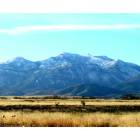
J-6 is not a place really (at least not formally). J-6 is an old subdivision first platted out in the 70's (I think). It exists on the south side of I-10 at the J-6/Mescal exit (about 5 minutes or so west of Benson - at the exact crest of the gentle rise that runs between the Whetstone Mountains to the south and the Rincon and Little Rincon Mountains to the north. If you look at this map (http://www.ocs.oregonstate.edu/pub/maps/Precipitation/Total/States/AZ/az.gif (broken link)) you can see where slightly heavier rainfall is along the county line between Cochise County (in the extreme SE corner of the state) and Pima County (the larger of the 2 counties immediately to the west of Cochise County).
The high point is almost exactly at the county line and that's where J-6 and Mescal are located (as is the J-6/Mescal exit). On that map you can spot the Whetstones to the south as a darker green blob sitting exactly on the county line and the twin areas of the Rincons and Little Rincons as blue spots (the one with a tiny purple center is the Rincons) to the north. As you can see, as you leave the ridgetop and head down the slope east towards Benson it gets dryer (and warmer).
Mescal is north of the freeway and is composed of smaller lots (1/4 acre or less (mostly) and is sort of rundown-looking (pretty run-down in some areas). J-6 is south of the freeway and is a bit nicer with minimum 1 acre lots with a mixture of mobile homes and site-built houses (some of them quite nice, others fairly basic) - as you can see in the photos taken near our land.
Now, to complicate things a bit let me throw in the fact that J-6 can mean J-6 Ranchettes - which is the development which I've been so far talking about (and where we own land) - or - it can mean J-6 Ranch. J-6 Ranch was apparently an original ranch in the area that gave the area it's name. It's gone now (as far as I know) but the name J-6 Ranch (as opposed to J-6 Ranchettes) is a name sometimes used for a new development going in on the south side of I-10 at the same exit.
The difference is, J-6 Ranchettes is predominantly on the WEST side of J-6 Ranch Road (which runs due south from the exit) whereas the J-6 Ranch development (which I've sometimes heard referred to as Easter Mountain Ranch) is on the EAST side of J-6 Ranch Road. The J-6 Ranch area is currently zoned for 4-acre lots (as opposed to the 1-acre lots of J-6 Ranchettes) but the Easter Mountain Ranch development company is in the process of trying to get a variance so as to re-zone that property for 2-acre lots (the trade-off being that they would add additional public landscaping etc to keep the density at about 1 house/3 acres. J-6 Ranch (or Easter Mountain Ranch - whatever you want to call it) would be pretty upscale and relatively expensive with no modular or moble homes (custom homes only).
I have been following the J-6 Ranch rezoning requests closely because one of the things that the Easter Mountain Ranch development company wants to do is to drill their wells on public land just south of J-6 Ranchettes (between J-6 Ranchettes and the Whetstone Mountains) rather than on J-6 Ranch property itself. This would put their wells directly "upstream" of our underground water source there at J-6 Ranchettes. (the rainfall over the nearby Whetstones is the source of our aquifer - hence the dark green spot on the map). This is apparently because their analysis says the bedrock beneath the J-6 Ranch location is too hard and too deep to effectively drill through. Needless to say, that's caused some concern for my neighbors at J-6 Ranchettes - who are afraid the water table will drop with 300+ new homes drawing from that aquifer (and "upstream" of us no less) and necessitating that the locals already living in J-6 Ranchettes drill new wells to go deeper (water depth in the area is around 325-375 feet) .
In response, the Easter Mountain Ranch company claims that its' hydroligists say there is a 100 year supply of water in the area - and the state has recently agreed.
Have I got you fully confused yet?
Ken
Last edited by LordBalfor; 04-17-2008 at 03:05 PM..
Ken you are an amazing source of information. THANK YOU for participating here. And your photos? AMAZING. I'm off to look at some more. I love seeing other peoples photos and yours are not disappointing.
Note that our property is marked (very faintly). This map is good because you can clearly see the location of the various mountain ranges (any areas that are green are essentially mountains).
Ken you are an amazing source of information. THANK YOU for participating here. And your photos? AMAZING. I'm off to look at some more. I love seeing other peoples photos and yours are not disappointing.
Thanks. Glad I could help.
I think I'm really a natural researcher at heart. Probably should have stuck with becoming a teacher and historian rather than a programmer.
In regards to the photos, take note of the fact that you can see a bigger image by clicking on the "Full Size" link in the upper right hand corner (though the trade off is that you won't see the photos comments/description when viewing that larger image). Often that larger version will automatically shrink down to your screen size. If want to see even more detail simply click on that resized image and it will expand back to it's full size (you'll have to scroll around to see the whole image then, but you'll see a lot more detail).
Anyway, good luck on your destination hunting. Take note that if you go to the area in May it will be very dry-looking. About half of the years rain tends to fall during the summer "monsoon" season (in the form of summer afternoon and evening thunderstorms - which are SPECTACULAR in the area, usually forming over each of the nearby mountain ranges and then fanning out over the surrounding plains and desert). This happens in July & August (which is why July & August tend to be a bit cooler than June (which is opposite of most other locations)).
Ken you are an amazing source of information. THANK YOU for participating here. And your photos? AMAZING. I'm off to look at some more. I love seeing other peoples photos and yours are not disappointing.
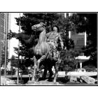
While you're at it, you might check out my wife's scupture (in two of the albums).
Very interesting! I loved the black women's faces.
Based on everything we hear and see from you, you're one lucky guy, Ken!
Thanks, I think so too.
Gail (my wife) is pretty talented in my opinion, but she's not the only one with talent in her family.
Her sister Treas is a very talented painter who actually makes a pretty good living at her art. Treas' husband Lionel passed away outside of Reno just two weeks ago and they were both very successful artists with paintings in many fine high-end galleries around the country in places like Las Vegas, South Lake Tahoe and Hawaii (not sure of the location). I returned here to Seattle a week ago after spending the previous week down there with Treas for the funeral etc. Gail's still down there helping Treas out.
I just spoke with Gail on the phone and she tells me Treas told her Lionel had wanted us to have one of his limited edition giclee prints. I'm thrilled of course since we were fans of Lionel since before he and Treas were even going out together (we'd bought one of his giclee's 18 years ago). Even better, the print he wanted us to have is one of our very favorites - one of his very last paintings (and some of the very best work he ever did). It's the painting known as Maple Bridge as seen here (near the bottom):
Vertu Publishing - New Paintings Gallery (http://www.vertupublishing.com/gallery.cfm?galleryID=5 - broken link)
Lionel was a highly skilled artist and a kind and wonderful man.
He will be missed very much.
Rest in Peace, Lionel.
No, it's NOT a dumb question and in fact the answer is a bit confusing so if what I'm about to write doesn't make sense to you, let me know and I'll try to rephase it.
J-6 is not a place really (at least not formally). J-6 is an old subdivision first platted out in the 70's (I think). It exists on the south side of I-10 at the J-6/Mescal exit (about 5 minutes or so west of Benson - at the exact crest of the gentle rise that runs between the Whetstone Mountains to the south and the Rincon and Little Rincon Mountains to the north. If you look at this map (http://www.ocs.oregonstate.edu/pub/maps/Precipitation/Total/States/AZ/az.gif (broken link)) you can see where slightly heavier rainfall is along the county line between Cochise County (in the extreme SE corner of the state) and Pima County (the larger of the 2 counties immediately to the west of Cochise County).
The high point is almost exactly at the county line and that's where J-6 and Mescal are located (as is the J-6/Mescal exit). On that map you can spot the Whetstones to the south as a darker green blob sitting exactly on the county line and the twin areas of the Rincons and Little Rincons as blue spots (the one with a tiny purple center is the Rincons) to the north. As you can see, as you leave the ridgetop and head down the slope east towards Benson it gets dryer (and warmer).
Mescal is north of the freeway and is composed of smaller lots (1/4 acre or less (mostly) and is sort of rundown-looking (pretty run-down in some areas). J-6 is south of the freeway and is a bit nicer with minimum 1 acre lots with a mixture of mobile homes and site-built houses (some of them quite nice, others fairly basic) - as you can see in the photos taken near our land.
Now, to complicate things a bit let me throw in the fact that J-6 can mean J-6 Ranchettes - which is the development which I've been so far talking about (and where we own land) - or - it can mean J-6 Ranch. J-6 Ranch was apparently an original ranch in the area that gave the area it's name. It's gone now (as far as I know) but the name J-6 Ranch (as opposed to J-6 Ranchettes) is a name sometimes used for a new development going in on the south side of I-10 at the same exit.
The difference is, J-6 Ranchettes is predominantly on the WEST side of J-6 Ranch Road (which runs due south from the exit) whereas the J-6 Ranch development (which I've sometimes heard referred to as Easter Mountain Ranch) is on the EAST side of J-6 Ranch Road. The J-6 Ranch area is currently zoned for 4-acre lots (as opposed to the 1-acre lots of J-6 Ranchettes) but the Easter Mountain Ranch development company is in the process of trying to get a variance so as to re-zone that property for 2-acre lots (the trade-off being that they would add additional public landscaping etc to keep the density at about 1 house/3 acres. J-6 Ranch (or Easter Mountain Ranch - whatever you want to call it) would be pretty upscale and relatively expensive with no modular or moble homes (custom homes only).
I have been following the J-6 Ranch rezoning requests closely because one of the things that the Easter Mountain Ranch development company wants to do is to drill their wells on public land just south of J-6 Ranchettes (between J-6 Ranchettes and the Whetstone Mountains) rather than on J-6 Ranch property itself. This would put their wells directly "upstream" of our underground water source there at J-6 Ranchettes. (the rainfall over the nearby Whetstones is the source of our aquifer - hence the dark green spot on the map). This is apparently because their analysis says the bedrock beneath the J-6 Ranch location is too hard and too deep to effectively drill through. Needless to say, that's caused some concern for my neighbors at J-6 Ranchettes - who are afraid the water table will drop with 300+ new homes drawing from that aquifer (and "upstream" of us no less) and necessitating that the locals already living in J-6 Ranchettes drill new wells to go deeper (water depth in the area is around 325-375 feet) .
In response, the Easter Mountain Ranch company claims that its' hydroligists say there is a 100 year supply of water in the area - and the state has recently agreed.
Have I got you fully confused yet?
Ken
I got the gist of what your saying and it was only confusing to a point but I got it! lol
And I have to agree, you really are knowledgeable!! And I thank you for your in site.
Gail (my wife) is pretty talented in my opinion, but she's not the only one with talent in her family.
Her sister Treas is a very talented painter who actually makes a pretty good living at her art. Treas' husband Lionel passed away outside of Reno just two weeks ago and they were both very successful artists with paintings in many fine high-end galleries around the country in places like Las Vegas, South Lake Tahoe and Hawaii (not sure of the location). I returned here to Seattle a week ago after spending the previous week down there with Treas for the funeral etc. Gail's still down there helping Treas out.
I just spoke with Gail on the phone and she tells me Treas told her Lionel had wanted us to have one of his limited edition giclee prints. I'm thrilled of course since we were fans of Lionel since before he and Treas were even going out together (we'd bought one of his giclee's 18 years ago). Even better, the print he wanted us to have is one of our very favorites - one of his very last paintings (and some of the very best work he ever did). It's the painting known as Maple Bridge as seen here (near the bottom):
Vertu Publishing - New Paintings Gallery (http://www.vertupublishing.com/gallery.cfm?galleryID=5 - broken link)
Lionel was a highly skilled artist and a kind and wonderful man.
He will be missed very much.
Rest in Peace, Lionel.
Ken
I'm sorry to hear of your loss, his art is beautiful.
Please register to post and access all features of our very popular forum. It is free and quick. Over $68,000 in prizes has already been given out to active posters on our forum. Additional giveaways are planned.
Detailed information about all U.S. cities, counties, and zip codes on our site: City-data.com.

 Please register to participate in our discussions with 2 million other members - it's free and quick! Some forums can only be seen by registered members. After you create your account, you'll be able to customize options and access all our 15,000 new posts/day with fewer ads.


 And your photos? AMAZING. I'm off to look at some more. I love seeing other peoples photos and yours are not disappointing.