Please register to participate in our discussions with 2 million other members - it's free and quick! Some forums can only be seen by registered members. After you create your account, you'll be able to customize options and access all our 15,000 new posts/day with fewer ads.
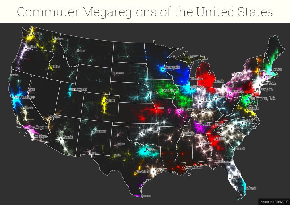
There is no way in hell Buffalo's "influence" stretches to the Mohawk Valley. It doesn't go past Rochester.
Eastern NY state (Mohawk Valley, Adirondacks, Albany, Hudson Valley) feels very much like New England.
I think you might be missing the point of the methodology. The key to looking at the regions is to divorce it from a known city that is embedded in the region. Think anew. These are interconnected areas by way of commuter and other factors. I would say read there methodology and visit the link in the OP and click on one of the maps and it will give you a close up that better shows how they region is connected.
If you click on the link and read through the article, you'll find the map where "state lines" are drawn up with no unclaimed territory left.
Did that..and their proposed states make even less sense than the current ones. It seems like someone thought "isn't it weird how people in the NYC metro actually live in three states" and then applied that across the rest of the country. But there's naturally far more to life and to the states than commuter patterns.
I like this kind of experiment in general and it's a cool mapping exercise, but they're overselling their work.
This might have been mentioned, but I'm not going back 5 pages.
1) I don't agree with Hartford extending all the way to SW Connecticut. I would extend New York up along Connecticut's coast all the way to New Haven. The New York "Mega Region" certainly doesn't end at the CT border and Hartford's influence simply isn't that large.
2) Albany up into the Burlington, Central and Northeast Kingdom regions of Vermont is absurd. Those areas should either be tied into Boston or be independent of any mega region. My girlfriend's family is from that area. Even though they're closer to Montreal, they're still far better connected to Boston. No matter how you cut it, Albany is a relative non-factor in the day to day life of Northern Vermont.
I think you are kind of trying to force this into being something that its not. I don't think they are saying that Buffalo influence extends to all those places more than other cities in the grouping does. I think that Buffalo just happens to be the largest metro or city in that defined mega region.
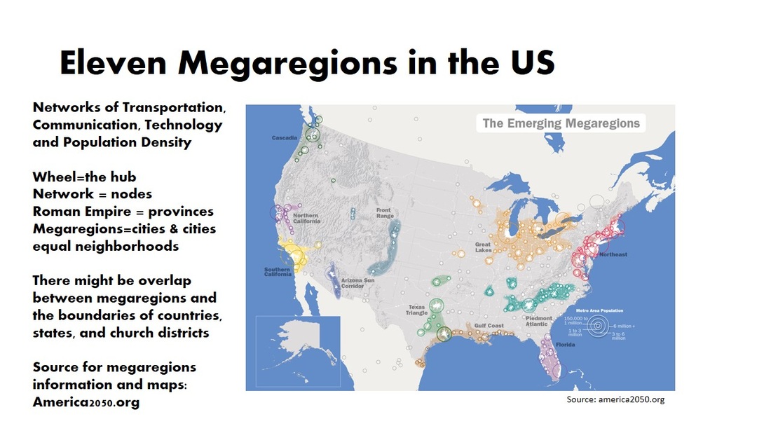
Look at this other mega region map
What the OP mega region map does is simply make the regions smaller and by commuter patterns. Take the "Great Lakes" Mega-region from the map above. They could have, instead of calling it the "Great Lakes Mega Region" instead called it the "Chicago" Mega-Region simply because that is the largest city in the defined area. That is all the OP mega region map does. Again, the authors, on a different site than the one linked to in the OP, give them different names not necessarily associated with a city.
It seems to me that this not a map that identifies commuting patterns to one central city within each "megaregion", rather a map that shows a network of cities that all have threads of connections among them. For example: In NC, the Triangle and Triad are two different employment centers, but the area in between the two provides a pool of exurb commuters to both. Likewise, the areas between the Triangle and Fayetteville, and Fayetteville and Wilmington work similarly. The more a core metro is closely clustered to other metros, the more the commuting web expands.
To go back to all the bickering about Richmond and Hampton Roads, this would mean that people who live between the two areas can commute to either, thus connecting them.
Nelson & Rae (the creators of the original map) incorrectly call the areas revealed by commuting patterns "mega-regions": they should, in fact, be understood as alternatives to the Census Bureau's definition of metropolitan areas, which is also based on commuting patterns.
As for actual "mega-regions," which, properly speaking, should encompass multiple metro areas, here is an alternative way (also recently published) to define mega-regions of the US. It divides all 3,142 counties of the US into the smallest number of regions that local residents could still find plausible, and based on ecoregions and economic ties rather than politics or "culture." The criteria for the project are listed in the link below. It defines regions bigger than Nelson & Rae's, i.e., "mega-regions" rather than metro areas; but unlike the America 2050 mega-regions, in this map every county of the US is assigned to a region.
No, absolutely not, I was going to say something is up with the map. I grew up in Iowa and love Des Moines and live in Chicago.
That green area in Illinois should absolutely be split between Chicago and St Louis.
In reality Chicago definitely spreads into the eastern part of Iowa. I grew up in eastern Iowa and Chicago was our big city, except the northern and southern fringes which gazed towards Minneapolis and St Louis. The eastern part of the state is within 150 miles of Chicago, and is heavily for the Bears and especially Bulls and Cubs. That draws a lot of influence. Also the University of Iowa has around 50% of its enrollment from Chicago and the Chicago suburbs which creates a big bubble of Chicago influence.
Please register to post and access all features of our very popular forum. It is free and quick. Over $68,000 in prizes has already been given out to active posters on our forum. Additional giveaways are planned.
Detailed information about all U.S. cities, counties, and zip codes on our site: City-data.com.

 Please register to participate in our discussions with 2 million other members - it's free and quick! Some forums can only be seen by registered members. After you create your account, you'll be able to customize options and access all our 15,000 new posts/day with fewer ads.