Please register to participate in our discussions with 2 million other members - it's free and quick! Some forums can only be seen by registered members. After you create your account, you'll be able to customize options and access all our 15,000 new posts/day with fewer ads.
My wife and I are planning to come to Greenville this weekend to see some friends, and hopefully do some hiking.
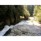
We've already hiked to the top Table Rock, Bald Rock, and done the Raven Falls trail.
Are there any other hikes that are similar to Table Rock - where you hike to mountain summit, and get a great view?
Any hikes that you all would recommend?
We're in our mid 20s, and in good shape, so most any trail recommendation should be fine. However, we would like to keep the total length to below 10 miles.
Falls Creek / Hospital Rock Trail comes to mind, or the Rim of the Gap Trail. Both are in Jones Gap SP.
Falls Creek Falls Trail, Rim of the Gap Trail, and Hosptial Rock Trail are all in Jones Gap State Park. You will find sort of "peek-a-boo" views on all three, but nothing like a couple of views from Pinnacle Pass Trail, also in Jones Gap.
I was just up Pinnacle Pass Sunday and have been up it several times. If you want to reach a great view where you just sit on a big rock outcrop like Caesar's Head or Table Rock, you can find one with just a 5 mile total distance (but an 1100 foot elevation gain) by starting at Jones Gap State Park and going up the Rim of the Gap Trail for .4 mile and then branching left onto Pinnacle Pass. You will reach the view in another 2 miles!
This view is North across the Jones Gap toward Hospital Rock. To return, just come back the way you ascended, or continue on until you get to the "6&20 Connector" and branch over to the Rim of the Gap Trail to descend. See the Map attached to the link above.
If you want a view to the South, so that you could see Greenville, etc. you could continue on the Pinnacle Pass Trail, but you would exceed your 10 mile limit by the time you returned! The best way to get to this other magnificent view is to start your hike by driving up Oil Camp Creek Rd. (which branches off of the River Falls Road toward Jones Gap) until it become dirt, proceeding on another 200 yards and parking by a State Park Sign. You continue up the primitive road on foot and after crossing Oil Camp Creek a couple of times (where it is again on your left) you will find a Park sign for a trail leading up the hill to the right. It will be the Pinnacle Pass Trail. If you go up the hill there for about 3 miles you will again gain about 800 feet and have a great view from a rock outcrop to the South. Total hike to this point and back is about 8 miles. You will encounter very few people on these trails, so be careful and carry food and water! Have fun.
Be aware that with this beautiful weather, you may want to enter Jones Gap Park by 11 AM on the weekend or the parking will be full and you will have to wait at the gate! (The option to drive up Oil Camp Creek avoids this possibility).
Yes, forgot the Pinnacle Pass Trail option. That would offer a higher viewpoint than the others, though all are good. Last I did that trail, my wife was several months pregnant - I think it was our last hike pre-children. Now that we have three, we are getting them into the hiking frame of mind, and they love it.
I was just up Pinnacle Pass Sunday and have been up it several times. If you want to reach a great view where you just sit on a big rock outcrop like Caesar's Head or Table Rock, you can find one with just a 5 mile total distance (but an 1100 foot elevation gain) by starting at Jones Gap State Park and going up the Rim of the Gap Trail for .4 mile and then branching left onto Pinnacle Pass. You will reach the view in another 2 miles!
This view is North across the Jones Gap toward Hospital Rock. To return, just come back the way you ascended, or continue on until you get to the "6&20 Connector" and branch over to the Rim of the Gap Trail to descend. See the Map attached to the link above.
Wow, thanks guys for the replies.
Thurx, we're staying in Jones Gap one night to camp, so the trail you posted will be right there, awesome!
One question, is it marked where it splits? (where it transitions from Rim of the Gap to Pinnacle Pass).
Thanks again guys, really looking forward to the hike, as well as camping.
Thurx, we're staying in Jones Gap one night to camp, so the trail you posted will be right there, awesome!
One question, is it marked where it splits? (where it transitions from Rim of the Gap to Pinnacle Pass).
Yes, there's a tall 8x8 post with the miles on it at the intersection. I think it will say something like "10 miles" for the Pinnacle Pass Trail, but that means all the way to the end at Caesar's Head. There may also be a new weatherproof map there at the intersection too. Seems like I saw one there.
Once you leave that intersection climbing up Pinnacle you will be headed more or less East along the side of the ridge. When you get up on the ridge you will then turn West and still have lots of climbing to do. After what seems a mile of climbing West the steepest climb will be near the end. At the right turn, out onto the view-rock be aware there seems to be a LEFT turn of the trail which actually detours around the view, and which I have taken in the past and missed the whole view! I've now piled some dead branches to partially block that route around the view spot, so watch for that and go RIGHT, not LEFT! You will be on the rock then in 30 seconds.
Looks like good weather this weekend, so have a great time, and after you get to the view, if you feel like you don't want to quit hiking quite yet, continue on the Pinnacle to the 6&20 connector (at this point you will be on an old road and the 6&20 will be a trail leading up-hill to the right and should have an 8x8 post marker). It will T out at the Rim of the Gap in less than a quarter mile, where you will then go right again and down a gradually descending trail! This will add another mile or 2 to your hike.
There are some great views from some of the peaks in Panthertown Valley in Cashiers, NC (maybe 1.5-2 hours from Greenville), not to mention numerous amazing waterfalls. There are also a ton of waterfalls near Wahalla and Westminister that are not as heavily visited as Table Rock and Raven Cliff.
Some of my favorite:
Blue Hole Falls
Rainbow Falls
Twin Falls
Brasstown Falls
My wife and I are planning to come to Greenville this weekend to see some friends, and hopefully do some hiking.
We've already hiked to the top Table Rock, Bald Rock, and done the Raven Falls trail.
Are there any other hikes that are similar to Table Rock - where you hike to mountain summit, and get a great view?
Any hikes that you all would recommend?
We're in our mid 20s, and in good shape, so most any trail recommendation should be fine. However, we would like to keep the total length to below 10 miles.
Thanks in advance.
The writer of a hiking book claims Bald Rock on Pinnacle Mountain has the best view in the state. He wrote this book prior to the new observation tower at Sassafras Mountain, the state high point.
Here are some hikes to overlooks in SC that are not well known.
Tammassee Knob. Trailhead is in the back of Oconee State Park near Walhalla. Best if done in the winter, late fall or early spring for views throughout the hike. The trail apparently gets overgrown in the summer. This is probably my favorite hike in the state because it is pretty easy and you can enjoy the nature more. You can add on a side hike to Hidden Falls. Oconee State Park is a cool place to hang out after the hike.
Big Rock. Located near Pickens. There are two main trailheads. I recommend the Preston McDaniel trailhead. Big Rock is a big boulder field on top of a mountain with a lot of side trails and overlooks including a bald rock overlook. It is pretty unique and probably would be a state park in most states.
Raven Cliff off Turkey Ridge Road in Long Creek. Hike less than a mile to a fantastic overlook of the Chattooga River above the Raven Chute rapid. I saw people kayak down the rapid yesterday. The overlook has a huge tree at the edge of the cliff and a small rockhouse behind it. You can hike to the river and Long Creek Falls right off the river on the same trail. The trail down and back up is very steep, probably steeper than any section of Table Rock.
Drawbar Cliffs - Drawbar Cliffs are about halfway (5 miles) between the Sassafras Mountain overlook and Table Rock State Park parking area. If you hike from Table Rock State park, you can stop at Bald Rock on the way. Drawbar Cliffs is about 1 mile from Bald Rock. If you hike from Sassafras, you will see the remnants of the John L. Cantrell homesite, one of the area’s earliest settlers. The hike continues past a rockhouse, Marion Castle's Rock House, where Civil War deserters supposedly stayed. There are some petroglyphs below the cliffs and a large curved opening known as The Lighthouse.
Raven Rock - A rock cliff on Lake Keowee located in Keowee Toxaway State Park. To get to the cliff, take the Natural Bridge Trail to the Raven Rock Trail. People jump off the cliff into the lake and there is a rope swing.
Raven Cliff Falls Suspension Bridge - Long difficult hike in Ceasars Head State Park to a suspension bridge over the top of the tallest waterfall in SC. There is also an unofficial side trail to see the waterfall from the side. The hike goes by a tall cliff known as The Cathederal.
South Carolina must have a lot of Edgar Allan Poe fans given all the stuff with Raven in the name.
Last edited by Huckleberry Knob; 03-14-2021 at 06:57 PM..
Please register to post and access all features of our very popular forum. It is free and quick. Over $68,000 in prizes has already been given out to active posters on our forum. Additional giveaways are planned.
Detailed information about all U.S. cities, counties, and zip codes on our site: City-data.com.

 Please register to participate in our discussions with 2 million other members - it's free and quick! Some forums can only be seen by registered members. After you create your account, you'll be able to customize options and access all our 15,000 new posts/day with fewer ads.