Please register to participate in our discussions with 2 million other members - it's free and quick! Some forums can only be seen by registered members. After you create your account, you'll be able to customize options and access all our 15,000 new posts/day with fewer ads.
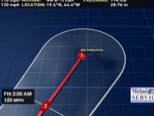
Within the last two hours, the storm rapidly intensified gaining 10MPH sustained winds and losing 16MB of pressure. The storm will continue strengthening until Thursday morning and maybe a chance of a Cat 5. Going to be real close to Bermuda.
On the plus side, because of Bermuda's tiny size, the chance of a direct landfall is pretty low. However, the island is projected to be on the right-hand side of Gonzalo, which is the more intense side of a Northern Hemisphere cyclone.
On the plus side, because of Bermuda's tiny size, the chance of a direct landfall is pretty low. However, the island is projected to be on the right-hand side of Gonzalo, which is the more intense side of a Northern Hemisphere cyclone.
On the other hand because of it's size that makes it more prone to trouble Especially with a large and powerful system like Gonzalo. But yeah, usually only around the eye is the worst.
Other areas can handle some flooding and wind damage.
Here's a current Satellite view. No chance for East coast threat since there's a huge system over the Ohio Valley and a strong front moving off shore now.
Please register to post and access all features of our very popular forum. It is free and quick. Over $68,000 in prizes has already been given out to active posters on our forum. Additional giveaways are planned.
Detailed information about all U.S. cities, counties, and zip codes on our site: City-data.com.

 Please register to participate in our discussions with 2 million other members - it's free and quick! Some forums can only be seen by registered members. After you create your account, you'll be able to customize options and access all our 15,000 new posts/day with fewer ads.