Please register to participate in our discussions with 2 million other members - it's free and quick! Some forums can only be seen by registered members. After you create your account, you'll be able to customize options and access all our 15,000 new posts/day with fewer ads.
Hi,
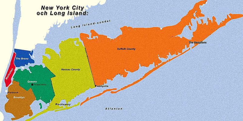
I was wondering if anyone here knew where I could find an accurate map of Long Island by county (Kings, Queens, Nassau, Suffolk), as the borders for the one on Wikipedia are highly off, especially when it comes to the Queens/Nassau border. I wasn't able to find much better searching Google. If anyone knows a good resource I'd appreciate it.
Thanks,
Hunter
I've already replied to OpMi in a DM, pointing out that the Hagstrom map will show the accurate border. (Actually, the Hagstrom map for, say, Nassau County, will show the accurate NYC (Queens County)/Nassau County and the Suffolk County/Nassau County borders.)
I contacted Hagstrom and they said, "the only Pocket Map we would have is the Long Island Roads, NY map. It has the various counties but doesn't clearly outline them." However, they said, I could order a custom map for several hundred dollars. I did find this website (County Boundary Map) on which if you click on each county on LI it will show you the borders. It does the job, though I'd love something a little bit more elegant. There has to be something like this (Rare Antique Maps: 1873 Beers Wall Map of Long Island, New York : Geographicus) updated 125 years or like this (Flickr Photo Download: Vintage Map of Long Island (http://www.flickr.com/photos/mr_t_in_dc/572785367/sizes/o/in/photostream/ - broken link)) updated 80 years that doesn't cost $500 bucks, right?
I contacted Hagstrom and they said, "the only Pocket Map we would have is the Long Island Roads, NY map. It has the various counties but doesn't clearly outline them." However, they said, I could order a custom map for several hundred dollars. I did find this website (County Boundary Map) on which if you click on each county on LI it will show you the borders. It does the job, though I'd love something a little bit more elegant. There has to be something like this (Rare Antique Maps: 1873 Beers Wall Map of Long Island, New York : Geographicus) updated 125 years or like this (Flickr Photo Download: Vintage Map of Long Island (http://www.flickr.com/photos/mr_t_in_dc/572785367/sizes/o/in/photostream/ - broken link)) updated 80 years that doesn't cost $500 bucks, right?
//www.city-data.com/forum/long-...au-queens.html has a link to a New York Times article and a hyper-accurate map showing the border between the New York City Borough of Queens (coterminous with New York State County of Queens) and Nassau County.
I love how parts of Eastern and Central Nassau are EAST of Southern Nassau and parts of Western Nassau are NORTH of Central Nassau.
Please register to post and access all features of our very popular forum. It is free and quick. Over $68,000 in prizes has already been given out to active posters on our forum. Additional giveaways are planned.
Detailed information about all U.S. cities, counties, and zip codes on our site: City-data.com.

 Please register to participate in our discussions with 2 million other members - it's free and quick! Some forums can only be seen by registered members. After you create your account, you'll be able to customize options and access all our 15,000 new posts/day with fewer ads.