Please register to participate in our discussions with 2 million other members - it's free and quick! Some forums can only be seen by registered members. After you create your account, you'll be able to customize options and access all our 15,000 new posts/day with fewer ads.
I would like to know some general information on Cedarvale.I have not been able to find much on the net.I know it's at a high elevation.My grandfather was born in Cedarvale in the 30's.He moved to Arkansas in the 40's or 50's.I know if it was in the 40's, it would have to have been after July of 1945 because he saw the Trinity Test.Thanks in advance.
-Troy
good morning from cold, sleeting Mississippi! I thought I should introduce myself before asking my question. New Mexico was my home for years until business and family took Us overseas. We landed in Mississippi when we returned to the States, but have already bought our next and hopefully permanent home in our hearts' desire, the land of enchantment.
So, still temporarily marooned in Mississippi, I have had fun looking through past threads about Corona, and have equally enjoyed a Google stroll around the area. But until we actually get to move there permanently, in a couple of years, it is hard to satisfy my eagerness to know more about the area.
specific questions:
tell me about Cedarvale?
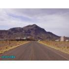
What is the landform to the east, a three-humped ridge that stands alone?
How many working ranches still exist in the area?
What are the best areas to ride (horses) to in the Cibola National Forest?
For those of you who live there, or nearby, what are the best and worst features of the area?
Thank you so much!
Dale
Last edited by Little rook; 01-09-2011 at 07:47 AM..
There isn't much to say about it other than it consists of a few abandoned buildings (including an old school house) and it appears on passing through the wide spot in the road that only a few trailer homes are now occupied. You can do a Google Street view from the hiway to get an idea of what is (isn't) there.
Corona is suffering the effects of the economic downturn after making a show of revival earlier. Now the number of active businesses are about what they were before the "revival" - meaning not much going on there now.
What is the landform to the east, a three-humped ridge that stands alone?
There are many basaltic features throughout that region. Volcanism is what built most of the land forms in NM.
How many working ranches still exist in the area?
Can't answer - and answer would depend on what is meant by "area."
What are the best areas to ride (horses) to in the Cibola National Forest?
The small section of Cibola to the west of Corona suffered a serious wildfire in recent years. Access is not all that difficult if you trailer your animals to a trailhead. Riding across private property that is fenced to get there may be asking for trouble.
For those of you who live there, or nearby, what are the best and worst features of the area?
IMO, best features are the isolation if you like living alone and far from neighbors and other aspects of town living. Worst features are lack of all amenities associated with a town - super markets, drug stores, full service library, health care, etc etc
Thanks, Joqua. I have actually been to Cedarvale, as I perhaps should have said, and found the scattering of buildings and what I take to be the old school evocative of another time. Searching Google led me to some oral histories of the area preserved in NM archives, but they only whetted my appetite. I was hoping that maybe someone who has personal history there might respond.
As for the landform -- yes, it is pretty obviously volcanic, as you say. But it is more dramatic than the other volcanic nubs (now I'm pretty sure that is not a technical term! ) and I was told it has a name and a history in the area. Again, hoping someone familiar with that might respond.
As for a definition of "area" for my question about ranches -- how about ranches from which the kids go to school in Corona? Would that be a good definition?
I know from reading the Corona town minutes that there are potentially delightful small town events that take place there. Hopefully someone can talk about those.
As for the Cibola National Forest portion west of Corona, I was actually wondering and should have been more specific about ruins, landforms, etc. that might be of interest therein.
Whenever I go through Cedarvale, I'm pulling my camper either back to Albuquerque or down to the land we have near Alto. As you know, there isn't a lot in Corona, but there is a ranch called Ranney. They pride themselves on grass-fed beef with no hormones..etc. I didn't even realize they were there until the day I was "googling" organic farms and ranches.
Actually...I DO love the drive from Willard to Corona. That's my favorite stretch on the trip from ABQ to Alto...although...I also enjoy the "heading into the mountains" part from Nogal to Alto.
By the way...I see you are in Mississippi. That's where I grew up. I'm curious where in MS you have landed...
Thank you, Mr G! Slowly gathering a picture of my future home...don't you love that drive from Willard to Corona?
I presume you're NOT talking about the highway surface itself? If you can afford to take your eyes off the road, or are a passenger, then it's not a bad ride and traffic is certainly not a problem. But as a driver, I wouldn't exactly call it a joy to drive!
Please register to post and access all features of our very popular forum. It is free and quick. Over $68,000 in prizes has already been given out to active posters on our forum. Additional giveaways are planned.
Detailed information about all U.S. cities, counties, and zip codes on our site: City-data.com.

 Please register to participate in our discussions with 2 million other members - it's free and quick! Some forums can only be seen by registered members. After you create your account, you'll be able to customize options and access all our 15,000 new posts/day with fewer ads.


 ) and I was told it has a name and a history in the area. Again, hoping someone familiar with that might respond.