Welcome to City-Data.com Forum!
U.S. CitiesCity-Data Forum Index
Go Back   City-Data Forum > General Forums > Weather
 [Register]
Please register to participate in our discussions with 2 million other members - it's free and quick! Some forums can only be seen by registered members. After you create your account, you'll be able to customize options and access all our 15,000 new posts/day with fewer ads.
View detailed profile (Advanced) or search
site with Google Custom Search

Search Forums  (Advanced)
Reply Start New Thread
 
Old 06-28-2012, 08:29 PM
 
Location: Near the Coast SWCT
83,525 posts, read 75,333,969 times
Reputation: 16620

Advertisements

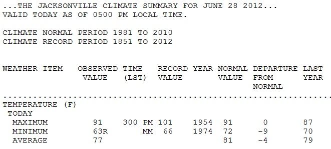
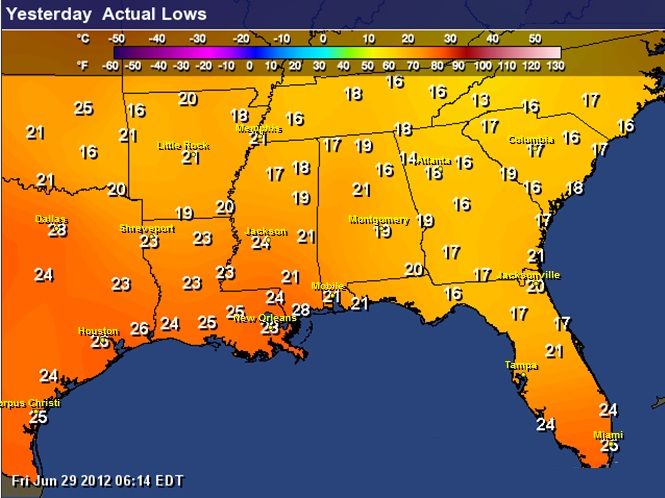
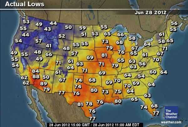
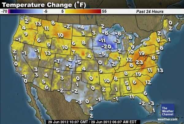
Massive amount of record lows and the media continues with the Highs. ITS SUMMER! Normal temps down south are 90s. I guess its all about the hype..

ALL RECORD LOWS HERE.
State Location Date New Record(°F) Previous Record(°F)

AL Centreville, 6 miles SW of Wed, 27 Jun 2012 58 61 in 1962
CA Redding Ap Wed, 27 Jun 2012 52 57 in 1968
FL Daytona Beach Intl Ap Wed, 27 Jun 2012 66 68 in 1938
FL Jacksonville Intl Ap Wed, 27 Jun 2012 66 67 in 1957
FL Mayo Wed, 27 Jun 2012 60 61 in 1933
FL Plant City Wed, 27 Jun 2012 53 63 in 1933
FL Quincy, 3 miles SSW of Wed, 27 Jun 2012 63 64 in 1940
GA Alma Bacon Co Ap Wed, 27 Jun 2012 63 65 in 1946
GA Ashburn, 3 miles ENE of Wed, 27 Jun 2012 60 61 in 1946
GA Augusta Bush Fld Ap Wed, 27 Jun 2012 56 61 in 1946
GA Brooklet, 1 miles W of Wed, 27 Jun 2012 60 63 in 1946
GA Camilla, 3 miles SE of Wed, 27 Jun 2012 60 64 in 1907
GA Colquitt, 2 miles W of Wed, 27 Jun 2012 64 64 in 1940
GA Cordele Wed, 27 Jun 2012 56 64 in 1946
GA Elberton, 2 miles N of Wed, 27 Jun 2012 52 59 in 1940
GA Helen Wed, 27 Jun 2012 54 54 in 1976
GA Macon Middle Ga Ap Wed, 27 Jun 2012 57 63 in 1954
GA Milledgeville Wed, 27 Jun 2012 58 59 in 1951
GA Sandersville Wed, 27 Jun 2012 58 60 in 1973
GA Savannah Intl Ap Wed, 27 Jun 2012 61 63 in 1946
GA Siloam, 3 miles N of Wed, 27 Jun 2012 55 59 in 1941
GA Valdosta, 2 miles S of Wed, 27 Jun 2012 64 64 in 1889
GA Warrenton Wed, 27 Jun 2012 56 58 in 1947
GA Waynesboro, 2 miles S of Wed, 27 Jun 2012 59 60 in 1954
HI Kula Branch Stn 324.5 Wed, 27 Jun 2012 54 54 in 1968
ID Garden Valley Wed, 27 Jun 2012 32 32 in 1943
ID Middle Fork Lodge Wed, 27 Jun 2012 33 34 in 1965
ID Stanley Wed, 27 Jun 2012 20 25 in 1961
IL Brookport Dam 52 Wed, 27 Jun 2012 54 55 in 1971
IL Cairo, 3 miles N of Wed, 27 Jun 2012 56 56 in 1959
IL La Harpe Wed, 27 Jun 2012 49 49 in 1935
IL Normal, 4 miles NE of Wed, 27 Jun 2012 48 49 in 1959
IN New Castle, 3 miles SW of Wed, 27 Jun 2012 48 48 in 1971
KY Barbourville Wed, 27 Jun 2012 49 49 in 1941
KY Jackson Wso Wed, 27 Jun 2012 54 54 in 1971
KY Lexington Bluegrass Ap Wed, 27 Jun 2012 51 53 in 1935
KY Mt Sterling Wed, 27 Jun 2012 49 49 in 1894
KY Paducah Barkley Ap Wed, 27 Jun 2012 54 54 in 1971
KY Paintsville, 1 miles E of Wed, 27 Jun 2012 50 50 in 1955
KY Rochester Ferry Wed, 27 Jun 2012 51 52 in 1959
KY Stearns, 2 miles S of Wed, 27 Jun 2012 47 48 in 1957
KY West Liberty, 3 miles NW of Wed, 27 Jun 2012 46 47 in 1925
MD Sines Deep Creek Wed, 27 Jun 2012 41 43 in 1922
MO Cape Girardeau Faa Ap Wed, 27 Jun 2012 53 53 in 1971
MS Columbus Wed, 27 Jun 2012 61 63 in 1962
MS Greenville Asos Wed, 27 Jun 2012 59 60 in 1925
MS Hickory Flat Wed, 27 Jun 2012 52 52 in 1941
MS Independence, 1 miles W of Wed, 27 Jun 2012 54 55 in 1941
MS Tylertown, 5 miles ESE of Wed, 27 Jun 2012 56 57 in 1941
MT Bozeman Montana St U Wed, 27 Jun 2012 32 32 in 1916
MT Divide Wed, 27 Jun 2012 32 32 in 1978
NC Cape Hatteras Ap Wed, 27 Jun 2012 61 61 in 1952
NC Charlotte Douglas Ap Wed, 27 Jun 2012 56 59 in 1946
NC Elizabethtown, 3 miles SW of Wed, 27 Jun 2012 54 56 in 1952
NC Laurinburg Wed, 27 Jun 2012 58 58 in 1946
NC Lincolnton, 4 miles W of Wed, 27 Jun 2012 53 53 in 1946
NC Longwood Wed, 27 Jun 2012 57 57 in 1951
NC Marshall Wed, 27 Jun 2012 46 46 in 1946
NC New Bern - Asos Wed, 27 Jun 2012 56 60 in 1922
NC Ocracoke Wed, 27 Jun 2012 61 65 in 1941
NC Roxboro, 7 miles ESE of Wed, 27 Jun 2012 50 50 in 1946
NC Tapoco Wed, 27 Jun 2012 49 52 in 1948
NC Whiteville, 7 miles NW of Wed, 27 Jun 2012 54 57 in 1955
NC Wilmington, 7 miles N of Wed, 27 Jun 2012 52 58 in 1922
NC Wilmington Intl Ap Wed, 27 Jun 2012 57 61 in 1922
NV Ely Airport Wed, 27 Jun 2012 33 33 in 1963
NV Gerlach Wed, 27 Jun 2012 41 43 in 1936
NV Wabuska, 6 miles SE of Wed, 27 Jun 2012 35 38 in 1942
OR Howard Prairie Dam Wed, 27 Jun 2012 31 31 in 1943
OR Monument 2 Wed, 27 Jun 2012 38 39 in 1938
OR Moro Wed, 27 Jun 2012 38 38 in 1942
PA Confluence 1 Sw Dam Wed, 27 Jun 2012 43 43 in 1952
SC Anderson Faa Ap Wed, 27 Jun 2012 59 61 in 1941
SC Andrews Wed, 27 Jun 2012 58 61 in 1951
SC Bamberg Wed, 27 Jun 2012 57 64 in 1941
SC Bishopville, 1 miles ENE of Wed, 27 Jun 2012 57 60 in 1951
SC Charleston Intl. Airport Wed, 27 Jun 2012 62 65 in 1934
SC Darlington Wed, 27 Jun 2012 57 57 in 1887
SC Dillon Wed, 27 Jun 2012 54 57 in 1951
SC Edisto Beach State Park Wed, 27 Jun 2012 65 65 in 1946
SC Florence Rgnl Ap Wed, 27 Jun 2012 58 60 in 1946
SC Johnston, 4 miles SW of Wed, 27 Jun 2012 56 57 in 1946
SC Lake City, 2 miles SE of Wed, 27 Jun 2012 57 59 in 1931
SC Little Mtn Wed, 27 Jun 2012 55 59 in 1946
SC Mccoll, 3 miles NNW of Wed, 27 Jun 2012 56 59 in 1955
SC Newberry Wed, 27 Jun 2012 57 60 in 1887
SC Ninety Nine Islands Wed, 27 Jun 2012 53 55 in 1951
SC North Myrtle Beach Wed, 27 Jun 2012 58 63 in 1963
SC Orangeburg 2 Wed, 27 Jun 2012 56 61 in 1946
SC Pickens Wed, 27 Jun 2012 56 56 in 1964
SC Sandhill Rsch Elgin Wed, 27 Jun 2012 57 61 in 1946
SC Santuck Wed, 27 Jun 2012 56 57 in 1887
SC Walterboro, 1 miles SW of Wed, 27 Jun 2012 58 60 in 1885
SC West Pelzer, 2 miles W of Wed, 27 Jun 2012 57 57 in 1946
SC Winnsboro Wed, 27 Jun 2012 58 59 in 1952
TN Ames Plantation Wed, 27 Jun 2012 52 55 in 1948
TN Greeneville Exp Stn Wed, 27 Jun 2012 49 49 in 1960
TN Jackson Mckellar- Sipes Ap Wed, 27 Jun 2012 53 53 in 1925
TN Neapolis Res Wed, 27 Jun 2012 50 55 in 1959
TN Smithville, 2 miles SE of Wed, 27 Jun 2012 49 49 in 1954
TX Marlin, 3 miles NE of Wed, 27 Jun 2012 58 59 in 1941
VA Danville Regional Ap Wed, 27 Jun 2012 52 54 in 1946
VA Grundy Wed, 27 Jun 2012 48 50 in 1946
VA Lynchburg Intl Ap Wed, 27 Jun 2012 50 53 in 1951
VA Martinsville Fltr Plt Wed, 27 Jun 2012 49 50 in 1948
VA Saltville, 1 miles N of Wed, 27 Jun 2012 47 50 in 1960
WA Ephrata Ap Wed, 27 Jun 2012 44 46 in 1942
WA Longmire Rainier Nps Wed, 27 Jun 2012 37 38 in 1978
WA Wenatchee Pangborn Memorial Ap Wed, 27 Jun 2012 47 48 in 1966
WA Yakima Ap Wed, 27 Jun 2012 38 38 in 1931
WI Oconto, 4 miles W of Wed, 27 Jun 2012 24 40 in 1872
WV Buckeye Wed, 27 Jun 2012 43 43 in 1952
WV Huntington Tri St Ap Wed, 27 Jun 2012 51 52 in 1948
WV Marlinton Wed, 27 Jun 2012 40 40 in 1894
WV Summersville Lake Wed, 27 Jun 2012 46 47 in 1952
WY Casper-natrona County Ap Wed, 27 Jun 2012 36 38 in 1978
Reply With Quote Quick reply to this message

 
Old 06-28-2012, 09:12 PM
 
Location: Near the Coast SWCT
83,525 posts, read 75,333,969 times
Reputation: 16620
Wow! Another record low today for Jacksonville! Hit 63 degrees! Almost July.
National Weather Service Climate

Reply With Quote Quick reply to this message
 
Old 06-29-2012, 03:24 AM
 
Location: Upstate, South Carolina
356 posts, read 677,634 times
Reputation: 155
in the SE these really were all caused by super low humidity and cooling at night unknown to the SE, maybe massive parts of the country turning to desert is the real story here.
Reply With Quote Quick reply to this message
 
Old 06-29-2012, 04:48 AM
 
Location: Laurentia
5,576 posts, read 8,000,929 times
Reputation: 2446
That's very interesting - they're still setting record lows? Wow. The high diurnal range works both ways across the heat wave-affected area, though I'm sure there are more record highs being broken than lows. Cambium is right in that we should be hearing much more about this aspect from the media. Not only is it a notable record event (like the highs they always report), it's also should be interesting to anyone that they're having weather more typical of the High Plains than the Southeast.
Reply With Quote Quick reply to this message
 
Old 06-29-2012, 05:08 AM
 
Location: Near the Coast SWCT
83,525 posts, read 75,333,969 times
Reputation: 16620
Default More Record Lows June 2012

Once again, lots of record lows yesterday.

Low 60s in Florida.. Chilly for almost July. Wow. Should be low 70s this time of year.

See map here. //www.city-data.com/forum/24952928-post88.html

State Location ..... Date .... New Record (°F) .... Previous Record (°F)

AL Centreville, 6 miles SW of Thu, 28 Jun 2012 58 60 in 1953
FL Clermont, 9 miles S of Thu, 28 Jun 2012 66 68 in 1963
FL Deland, 1 miles SSE of Thu, 28 Jun 2012 62 63 in 1883
FL Hastings, 4 miles NE of Thu, 28 Jun 2012 63 64 in 1959
FL High Springs Thu, 28 Jun 2012 62 62 in 1956
FL Madison Thu, 28 Jun 2012 61 65 in 1934
FL Mayo Thu, 28 Jun 2012 61 62 in 1940
FL Quincy, 3 miles SSW of Thu, 28 Jun 2012 59 59 in 1934
FL Sanford Thu, 28 Jun 2012 65 68 in 1956
GA Homerville, 5 miles N of Thu, 28 Jun 2012 60 60 in 1934
GA Nahunta, 6 miles NE of Thu, 28 Jun 2012 59 64 in 1945
GA Valdosta, 2 miles S of Thu, 28 Jun 2012 61 61 in 1934
GA Warrenton Thu, 28 Jun 2012 55 58 in 1953
IL Brookport Dam 52 Thu, 28 Jun 2012 53 55 in 1958
IN Greencastle, 1 miles W of Thu, 28 Jun 2012 50 50 in 1920
KY Barbourville Thu, 28 Jun 2012 48 49 in 1962
KY Jamestown Wwtp Thu, 28 Jun 2012 49 52 in 1969
KY Mt Sterling Thu, 28 Jun 2012 47 47 in 1892
KY West Liberty, 3 miles NW of Thu, 28 Jun 2012 47 47 in 1953
MO Clearwater Dam Thu, 28 Jun 2012 50 50 in 1940
MS Independence, 1 miles W of Thu, 28 Jun 2012 56 56 in 1958
MT Sidney Thu, 28 Jun 2012 32 41 in 1915
NC Boone, 1 miles SE of Thu, 28 Jun 2012 43 47 in 1953
NC Jefferson, 2 miles E of Thu, 28 Jun 2012 41 43 in 1936
NC Marshall Thu, 28 Jun 2012 46 47 in 1936
NC Wilmington, 7 miles N of Thu, 28 Jun 2012 54 54 in 1947
OR John Day Thu, 28 Jun 2012 35 37 in 1941
SC Walterboro, 1 miles SW of Thu, 28 Jun 2012 58 58 in 1954
TN Ames Plantation Thu, 28 Jun 2012 55 56 in 1958
TN Erwin, 1 miles W of Thu, 28 Jun 2012 50 51 in 1953
TN Smithville, 2 miles SE of Thu, 28 Jun 2012 43 50 in 1958
VA Saltville, 1 miles N of Thu, 28 Jun 2012 47 49 in 1958
WV Marlinton Thu, 28 Jun 2012 41 41 in 1954
Reply With Quote Quick reply to this message
 
Old 06-29-2012, 05:09 AM
 
Location: Near the Coast SWCT
83,525 posts, read 75,333,969 times
Reputation: 16620
For my Celsius friends here's how the SouthEast U.S looks.

Reply With Quote Quick reply to this message
 
Old 06-29-2012, 05:11 AM
 
Location: Near the Coast SWCT
83,525 posts, read 75,333,969 times
Reputation: 16620
And here's the bigger picture... with all the hype about heat, one wouldnt know there's actually a coldwave going on too. If you find out what the normal lows are, you'll understand many areas are actually chilly compared to it.

Reply With Quote Quick reply to this message
 
Old 06-29-2012, 05:16 AM
 
Location: Near the Coast SWCT
83,525 posts, read 75,333,969 times
Reputation: 16620
Wow, look at that... 20 degree temp change in upper mid west... Must be a chillywave coming through. Temps in the 50sF there. 10-15C.


My point in all this is... we can all pick and choose...

Both sides will always be there but I believe Record Highs and Lows in Winter or Summer should be recognized. Not just the Highs, not just the heatwaves. Essentially they are brainwashing us to thinking all thats happening is warming, when in fact, its not.


Reply With Quote Quick reply to this message
 
Old 06-29-2012, 06:27 AM
 
Location: Upstate, South Carolina
356 posts, read 677,634 times
Reputation: 155
This weather simply is not normal, the record lows are due to the dry air covering the country. This is hardly a coldwave though, that is really quite a spin on what is happening.

I will say this is much more pleasant then last year's high 90's with high humidity, I'm not going to be too upset if we stay desert like this summer. I had enough humidity last year.
Reply With Quote Quick reply to this message
 
Old 06-29-2012, 06:58 AM
 
Location: Near the Coast SWCT
83,525 posts, read 75,333,969 times
Reputation: 16620
Quote:
Originally Posted by scme5 View Post
This weather simply is not normal, the record lows are due to the dry air covering the country. This is hardly a coldwave though, that is really quite a spin on what is happening.
.
Exactly...and so is a Ridge in the summer with 90s. (yes, 100s are extreme and record breaking but they were localized) Its summer, 90s happen but they spin it all the time. My status once said "The Spin Stops Here"... I might have to put that up with every heat wave they show. LOL
Reply With Quote Quick reply to this message
Please register to post and access all features of our very popular forum. It is free and quick. Over $68,000 in prizes has already been given out to active posters on our forum. Additional giveaways are planned.

Detailed information about all U.S. cities, counties, and zip codes on our site: City-data.com.


Reply
Please update this thread with any new information or opinions. This open thread is still read by thousands of people, so we encourage all additional points of view.

Quick Reply
Message:


Over $104,000 in prizes was already given out to active posters on our forum and additional giveaways are planned!

Go Back   City-Data Forum > General Forums > Weather

All times are GMT -6. The time now is 01:49 PM.

© 2005-2024, Advameg, Inc. · Please obey Forum Rules · Terms of Use and Privacy Policy · Bug Bounty

City-Data.com - Contact Us - Archive 1, 2, 3, 4, 5, 6, 7, 8, 9, 10, 11, 12, 13, 14, 15, 16, 17, 18, 19, 20, 21, 22, 23, 24, 25, 26, 27, 28, 29, 30, 31, 32, 33, 34, 35, 36, 37 - Top