Welcome to City-Data.com Forum!
U.S. CitiesCity-Data Forum Index
Go Back   City-Data Forum > General Forums > Weather
 [Register]
Please register to participate in our discussions with 2 million other members - it's free and quick! Some forums can only be seen by registered members. After you create your account, you'll be able to customize options and access all our 15,000 new posts/day with fewer ads.
View detailed profile (Advanced) or search
site with Google Custom Search

Search Forums  (Advanced)
 
Old 11-25-2014, 10:10 AM
 
Location: West Orange, NJ
267 posts, read 352,186 times
Reputation: 151

Advertisements

now i'm in the 6-8inch path...lovely
National Weather Service Forecast Office - Upton, NY
Reply With Quote Quick reply to this message

 
Old 11-25-2014, 11:57 AM
 
Location: Near the Coast SWCT
83,520 posts, read 75,307,397 times
Reputation: 16620
Airport delays forecast.

https://twitter.com/CNNweather/statu...224000/photo/1


Boston on the 6-12" edge but nei is inside the 6-12". I hope he gets 12. lol

Reply With Quote Quick reply to this message
 
Old 11-25-2014, 12:07 PM
 
Location: Near the Coast SWCT
83,520 posts, read 75,307,397 times
Reputation: 16620
There it is... see it diving down? See the frontal boundary off the east coast? Time to develop a storm and inject some cold air now.

Moisture right from the Pacific and Gulf riding the Subtropical Jet stream

http://www.ssd.noaa.gov/goes/comp/nhem/wv-animated.gif

Reply With Quote Quick reply to this message
 
Old 11-25-2014, 12:13 PM
nei nei won $500 in our forum's Most Engaging Poster Contest - Thirteenth Edition (Jan-Feb 2015). 

Over $104,000 in prizes has already been given out to active posters on our forum and additional contests are planned
 
Location: Western Massachusetts
45,983 posts, read 53,485,386 times
Reputation: 15184
Quote:
Originally Posted by Cambium View Post

Boston on the 6-12" edge but nei is inside the 6-12". I hope he gets 12. lol
Thanks. Hope I've left the area well before that happens. And don't drive in it. I could wait till Thursday morning but I don't have a garage so sweeping my car will be an extra pain and the roads will stay be messy. Doable, but if I can leave tonight or Wednesday morning why bother?
Reply With Quote Quick reply to this message
 
Old 11-25-2014, 12:23 PM
 
Location: Near the Coast SWCT
83,520 posts, read 75,307,397 times
Reputation: 16620
Quote:
Originally Posted by nei View Post
Thanks.
lol. Hey, we've had enough time between snowstorms. No? Lets break some records now. How about 120" by season end for us? lol

Quote:
Originally Posted by nei View Post
Hope I've left the area well before that happens. And don't drive in it. I could wait till Thursday morning ...
Leave before sunrise Wednesday or Thursday like you said. Don't get caught north of I-84 after lunch
Reply With Quote Quick reply to this message
 
Old 11-25-2014, 12:25 PM
 
Location: Near the Coast SWCT
83,520 posts, read 75,307,397 times
Reputation: 16620
Capital Weather Gang shows 10 different forecasts for mid Atlantic. Very cool !

The wonderful world of weather forecasters: How much snow is everyone predicting for D.C. Wednesday? - The Washington Post


Here's one

Reply With Quote Quick reply to this message
 
Old 11-25-2014, 12:29 PM
 
Location: Ashburn, VA
2,794 posts, read 2,933,605 times
Reputation: 4914
Here's a compilation of snow total forecasts for Philadelphia, Lehigh Valley, and Pocono news stations...


Reply With Quote Quick reply to this message
 
Old 11-25-2014, 12:33 PM
nei nei won $500 in our forum's Most Engaging Poster Contest - Thirteenth Edition (Jan-Feb 2015). 

Over $104,000 in prizes has already been given out to active posters on our forum and additional contests are planned
 
Location: Western Massachusetts
45,983 posts, read 53,485,386 times
Reputation: 15184
Quote:
Originally Posted by Cambium View Post
Leave before sunrise Wednesday or Thursday like you said. Don't get caught north of I-84 after lunch
Wednesday morning looks ok, though perhaps a bit risky, especially if there's heavy traffic.

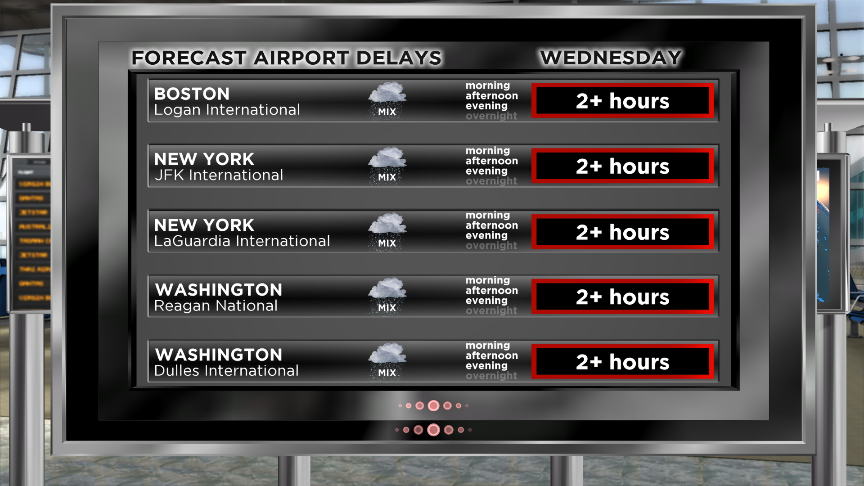
TIMING...A MIXTURE OF RAIN AND SNOW BEGINNING WEDNESDAY
MORNING SHOULD CHANGE TO ALL SNOW THROUGH WEDNESDAY AFTERNOON
CONTINUING THROUGH WEDNESDAY NIGHT INTO THURSDAY MORNING. THE
HEAVIEST SNOW SHOULD OCCUR WEDNESDAY AFTERNOON AND EVENING.
Reply With Quote Quick reply to this message
 
Old 11-25-2014, 12:35 PM
 
29,531 posts, read 19,620,154 times
Reputation: 4544
Lucky bastards

Reply With Quote Quick reply to this message
 
Old 11-25-2014, 12:37 PM
nei nei won $500 in our forum's Most Engaging Poster Contest - Thirteenth Edition (Jan-Feb 2015). 

Over $104,000 in prizes has already been given out to active posters on our forum and additional contests are planned
 
Location: Western Massachusetts
45,983 posts, read 53,485,386 times
Reputation: 15184
Buffalo's missing out.
Reply With Quote Quick reply to this message
Please register to post and access all features of our very popular forum. It is free and quick. Over $68,000 in prizes has already been given out to active posters on our forum. Additional giveaways are planned.

Detailed information about all U.S. cities, counties, and zip codes on our site: City-data.com.


Reply
Please update this thread with any new information or opinions. This open thread is still read by thousands of people, so we encourage all additional points of view.

Quick Reply
Message:


Over $104,000 in prizes was already given out to active posters on our forum and additional giveaways are planned!

Go Back   City-Data Forum > General Forums > Weather

All times are GMT -6. The time now is 07:05 PM.

© 2005-2024, Advameg, Inc. · Please obey Forum Rules · Terms of Use and Privacy Policy · Bug Bounty

City-Data.com - Contact Us - Archive 1, 2, 3, 4, 5, 6, 7, 8, 9, 10, 11, 12, 13, 14, 15, 16, 17, 18, 19, 20, 21, 22, 23, 24, 25, 26, 27, 28, 29, 30, 31, 32, 33, 34, 35, 36, 37 - Top