Welcome to City-Data.com Forum!
U.S. CitiesCity-Data Forum Index
Go Back   City-Data Forum > General Forums > Weather
 [Register]
Please register to participate in our discussions with 2 million other members - it's free and quick! Some forums can only be seen by registered members. After you create your account, you'll be able to customize options and access all our 15,000 new posts/day with fewer ads.
View detailed profile (Advanced) or search
site with Google Custom Search

Search Forums  (Advanced)
 
Old 10-25-2015, 10:08 AM
 
Location: Mid Atlantic USA
12,623 posts, read 13,929,460 times
Reputation: 5895

Advertisements

Quote:
Originally Posted by chicagogeorge View Post
^^

Yup. Might this be the pattern going forward into winter? As of now I see no influence coming from the North Pacific Blob. It's the El Nino show.

Look at the SST's in the North Pacific. They are really starting to come down. Still above average but the bright reds are disappearing.


Look where they were last October and last March


And a couple more powerful lows moving towards there this week will churn that water up even more


Next few days

George you should come over to philly this winter. I really think, based on a few blogs and the patter now, that the northeast and midatlantic will get all the cold.
Reply With Quote Quick reply to this message

 
Old 10-25-2015, 10:42 AM
 
Location: Near the Coast SWCT
83,520 posts, read 75,307,397 times
Reputation: 16620
Who's reporting what right now

It's amazing to continue to see snow in Ontario/Quebec. Wonder what those residents have been saying and how much is actually on the ground. Wish I had easy access to stations in Canada. 850mb temps remain below freezing there.

Texas & LA getting hammered with rainfall

Ignore that heavy snow report in North Dakota, pretty sure an error right now

Reply With Quote Quick reply to this message
 
Old 10-25-2015, 11:12 AM
 
Location: Lexington, KY
12,278 posts, read 9,454,092 times
Reputation: 2763
Cloudy and in the 50s today. Didn't feel as cold as I expected.
Reply With Quote Quick reply to this message
 
Old 10-25-2015, 11:38 AM
 
Location: Near the Coast SWCT
83,520 posts, read 75,307,397 times
Reputation: 16620
Quote:
Originally Posted by G8RCAT View Post
Cloudy and in the 50s today. Didn't feel as cold as I expected.
Here too.. 60F at 1:30pm. Feels a bit warm. I think our bodies are adjusting. Soon 50s will feel tropical.

Current temps.

Reply With Quote Quick reply to this message
 
Old 10-25-2015, 11:46 AM
 
29,531 posts, read 19,620,154 times
Reputation: 4544
Quote:
Originally Posted by tom77falcons View Post
George you should come over to philly this winter. I really think, based on a few blogs and the patter now, that the northeast and midatlantic will get all the cold.
I think you'll get more action then me. Got a feeling that this will be a banner year for Nor' Easters.
Reply With Quote Quick reply to this message
 
Old 10-25-2015, 12:38 PM
 
Location: New Jersey
15,318 posts, read 17,221,445 times
Reputation: 6959
Cloudy and mild today. Temperature at 2:30PM is 64 F/18 C.
Reply With Quote Quick reply to this message
 
Old 10-25-2015, 12:52 PM
 
Location: Indiana Uplands
26,411 posts, read 46,581,861 times
Reputation: 19559
Quote:
Originally Posted by chicagogeorge View Post
I think you'll get more action then me. Got a feeling that this will be a banner year for Nor' Easters.
I agree with this reasoning. I think places on the SW edge of the Midwest like Kansas City will have very little winter at all.
Reply With Quote Quick reply to this message
 
Old 10-25-2015, 01:03 PM
 
Location: New Jersey
15,318 posts, read 17,221,445 times
Reputation: 6959
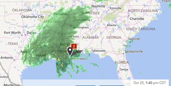
Still raining in Southeast Texas. Looks like the heaviest rain is in Louisiana. Rain also in Tennessee, Arkansas, and Mississippi. Flood watches extend from Texas to Florida.


...LOCALLY HEAVY RAIN LIKELY TODAY THROUGH MONDAY MORNING...

.A SURFACE LOW MOVING THROUGH THE NORTHERN GULF WILL BRING
POTENTIALLY HEAVY RAINFALL TO SOUTHEAST LOUISIANA AND SOUTHERN
MISSISSIPPI TODAY THROUGH MONDAY MORNING. AS MUCH AS 4 TO 7
INCHES OF RAIN WITH LOCALLY HIGHER AMOUNTS WILL BE POSSIBLE AND
THIS COULD RESULT IN LOCALIZED FLASH FLOODING.

National Weather Service Watch Warning Advisory Summary

Wind Advisories are also in effect in Texas, Louisiana, and Arkansas.

...WIND ADVISORY NOW IN EFFECT FOR ALL OF SOUTHEAST TEXAS THROUGH
EARLY MONDAY MORNING...

.STRONG NORTH WINDS CAN BE EXPECTED ACROSS THE AREA AS LOW
PRESSURE MOVES INTO LOUISIANA. WINDS SHOULD BEGIN TO DECREASE
THIS EVENING AND OVERNIGHT...AND THAT IS WHEN SOME OF THE INLAND
COUNTIES WILL LIKELY BE DROPPED FROM THE ADVISORY.

EVENT...NORTH WINDS AT 20 TO 30 MPH WITH STRONGER GUSTS CLOSE
TO 40 MPH.

* TIMING...ALL DAY TODAY. WINDS SHOULD DECREASE THIS EVENING AND
OVERNIGHT.

* IMPACT...EXPECT GUSTY WINDS CAPABLE OF MOVING AROUND ITEMS NOT
ANCHORED TO THE GROUND. DRIVERS SHOULD USE CAUTION...
ESPECIALLY WHEN DRIVING ALONG EAST TO WEST ORIENTED ROADS.

National Weather Service Watch Warning Advisory Summary

Not good in areas that are waterlogged.
Reply With Quote Quick reply to this message
 
Old 10-25-2015, 01:07 PM
 
Location: New Jersey
15,318 posts, read 17,221,445 times
Reputation: 6959
Quote:
Hurricane Patricia was a tropical cyclone that formed in the eastern Pacific and rapidly intensified into a Category 5 hurricane. Even more quickly than the storm strengthened, it rapidly weakened over the rugged terrain of Mexico.

Patricia initially formed on Oct. 20, 2015 and dissipated on Oct. 24, 2015.

Looking Back at Patricia
Just 30 hours after peaking in intensity as the most powerful tropical cyclone ever measured in the Western Hemisphere, former Hurricane Patricia degenerated into a weak remnant low over northeast Mexico.

On Oct. 23, Patricia became the most powerful tropical cyclone ever measured in the Western Hemisphere as its maximum sustained winds reached an unprecedented 200 mph (320 kph) and its central pressure fell to 879 millibars (25.96 inches of mercury).

....

Only one Category 5 hurricane had ever previously been known to make landfall on Mexico's Pacific coast. That hurricane followed a path similar to that of Hurricane Patricia and struck near Puerto Vallarta in late October 1959, causing some 1,800 deaths.
http://www.weather.com/storms/hurric...a-mexico-coast
Reply With Quote Quick reply to this message
 
Old 10-25-2015, 01:36 PM
 
Location: 48.0710° N, 118.1989° W
590 posts, read 714,606 times
Reputation: 885
Can anyone here chime in with their thoughts/predictions on PNW winter 15'-16'? You can see my location coordinates....I'd love a repeat of 2010-2011 winter. Or better yet....a massive snow storm that stalls over me for days and days...snowmachine is collecting dust in the shop
Reply With Quote Quick reply to this message
Please register to post and access all features of our very popular forum. It is free and quick. Over $68,000 in prizes has already been given out to active posters on our forum. Additional giveaways are planned.

Detailed information about all U.S. cities, counties, and zip codes on our site: City-data.com.


Reply
Please update this thread with any new information or opinions. This open thread is still read by thousands of people, so we encourage all additional points of view.

Quick Reply
Message:


Over $104,000 in prizes was already given out to active posters on our forum and additional giveaways are planned!

Go Back   City-Data Forum > General Forums > Weather

All times are GMT -6. The time now is 06:57 PM.

© 2005-2024, Advameg, Inc. · Please obey Forum Rules · Terms of Use and Privacy Policy · Bug Bounty

City-Data.com - Contact Us - Archive 1, 2, 3, 4, 5, 6, 7, 8, 9, 10, 11, 12, 13, 14, 15, 16, 17, 18, 19, 20, 21, 22, 23, 24, 25, 26, 27, 28, 29, 30, 31, 32, 33, 34, 35, 36, 37 - Top