Bridgeport neighborhood in Safety Harbor, Florida (FL), 34695 detailed profile
Settings
X


Business Search - 14 Million verified businesses
Area: 2.740 square miles
Population: 3,754
Population density:
| Bridgeport: | 1,370 people per square mile |
| Safety Harbor: | 3,475 people per square mile |

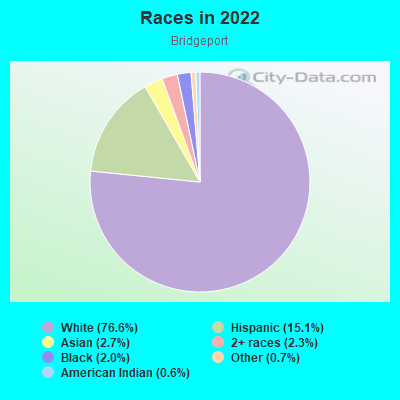
- 2,92076.6%White
- 57515.1%Hispanic or Latino
- 1022.7%Asian
- 882.3%Two or more races
- 752.0%Black
- 250.7%Some other race
- 220.6%American Indian
- 30.08%Native Hawaiian and Other
Pacific Islander
Median household income in 2022:
| Bridgeport: | $97,816 |
| Safety Harbor: | $102,670 |
Distribution of median household income
![Distribution of median household income]()
- 27Less than $10,000
- 71$10,000 to $19,999
- 105$20,000 to $29,999
- 88$30,000 to $39,999
- 71$40,000 to $49,999
- 44$50,000 to $59,999
- 136$60,000 to $74,999
- 102$75,000 to $99,999
- 164$100,000 to $124,999
- 149$125,000 to $149,999
- 276$150,000 to $199,999
- 484$200,000 or more

Distribution of owner-occupied house/condo value
![Distribution of owner-occupied house/condo value]()
- 346Less than $50,000
- 284$50,000 to $99,999
- 111$100,000 to $149,999
- 97$150,000 to $199,999
- 82$200,000 to $249,999
- 80$250,000 to $299,999
- 323$300,000 to $399,999
- 284$400,000 to $499,999
- 499$500,000 to $749,999
- 205$750,000 to $999,999
- 139$1,000,000 or more

Distribution of rent paid by renters
![Distribution of rent paid by renters]()
- 16$100 to $199
- 63$300 to $399
- 43$400 to $499
- 34$600 to $699
- 48$700 to $799
- 29$800 to $899
- 63$900 to $999
- 29$1,000 to $1,249
- 55$1,250 to $1,499
- 178$1,500 to $1,999
- 198$2,000 or more

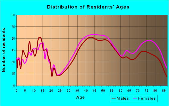
| Males: | 1,875 |
| Females: | 1,878 |
Males:
| This neighborhood: | 46.0 years |
| Whole city: | 45.6 years |
| This neighborhood: | 47.6 years |
| Whole city: | 48.6 years |
Average household size:
| Bridgeport: | 2.5 people |
| Safety Harbor: | 2.5 people |
Percentage of family households:
| Bridgeport: | 58.9% |
| Safety Harbor: | 46.3% |
| Here: | 66.8% |
| Safety Harbor: | 52.5% |
Percentage of married-couple families with children (among all households):
| Bridgeport: | 29.8% |
| Safety Harbor: | 28.4% |
Percentage of single-mother households (among all households):
| Bridgeport: | 6.7% |
| Safety Harbor: | 7.9% |
Percentage of never married males 15 years old and over:
Percentage of never married females 15 years old and over:
| Bridgeport: | 11.1% |
| Safety Harbor: | 12.3% |
Percentage of never married females 15 years old and over:
| Bridgeport: | 11.7% |
| city: | 15.0% |
Percentage of people that speak English not well or not at all:
| Bridgeport: | 1.1% |
| Safety Harbor: | 0.6% |
Percentage of people born in this state:
Percentage of people born in another U.S. state:
Percentage of native residents but born outside the U.S.:
Percentage of foreign born residents:
| Here: | 29.4% |
| Safety Harbor: | 34.4% |
Percentage of people born in another U.S. state:
| Bridgeport: | 61.4% |
| Safety Harbor: | 54.9% |
Percentage of native residents but born outside the U.S.:
| Here: | 0.9% |
| city: | 1.9% |
Percentage of foreign born residents:
| Here: | 8.3% |
| Safety Harbor: | 8.9% |
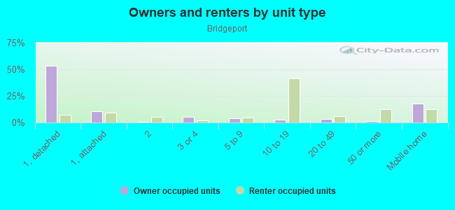
Owner-occupied
Renter-occupied

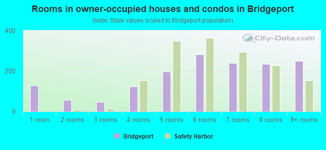
- Rooms in owner-occupied houses and condos in Bridgeport
- 1291 room
- 582 rooms
- 483 rooms
- 1234 rooms
- 1985 rooms
- 2826 rooms
- 2397 rooms
- 2348 rooms
- 2509+ rooms
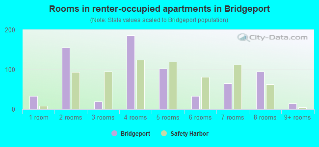
- Rooms in renter-occupied apartments in Bridgeport
- 331 room
- 1552 rooms
- 203 rooms
- 1864 rooms
- 1025 rooms
- 336 rooms
- 657 rooms
- 958 rooms
- 159+ rooms
Owner-occupied
Renter-occupied
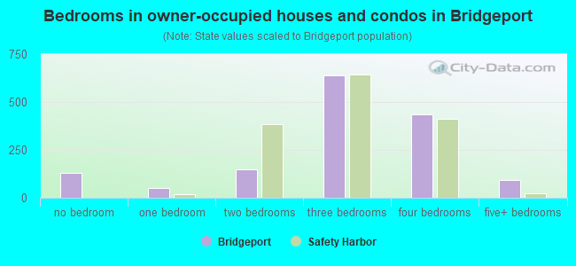
- Bedrooms in owner-occupied houses and condos in Bridgeport
- 129no bedroom
- 491 bedroom
- 1462 bedrooms
- 6383 bedrooms
- 4354 bedrooms
- 925+ bedrooms
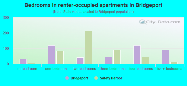
- Bedrooms in renter-occupied apartments in Bridgeport
- 33no bedroom
- 1201 bedroom
- 432 bedrooms
- 473 bedrooms
- 1204 bedrooms
- 915+ bedrooms
Average number of cars or other vehicles available in houses/condos:
Average number of cars or other vehicles available in apartments:
| This neighborhood: | 1.5 |
| Safety Harbor: | 1.9 |
Average number of cars or other vehicles available in apartments:
| Here: | 6.5 |
| city: | 1.4 |
Percentage of units with a mortgage:
| Bridgeport: | 59.2% |
| Safety Harbor: | 60.6% |
Average estimated value of detached houses in 2022 (82.3% of all units):
| Bridgeport: | $519,328 |
| Florida: | $500,941 |
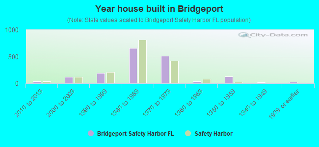
- Year house built in Bridgeport
- 62020 or later
- 342010 to 2019
- 1152000 to 2009
- 1941990 to 1999
- 6631980 to 1989
- 5171970 to 1979
- 341960 to 1969
- 1271950 to 1959
- 211940 to 1949
- 241939 or earlier
City-data.com crime index for city in 2020 (higher means more crime):
| City: | 110.3 |
| U.S. average: | 219.5 |
Travel time to work (commute)
![Travel time to work (commute)]()
- 26Less than 5 minutes
- 755 to 9 minutes
- 23510 to 14 minutes
- 30315 to 19 minutes
- 19120 to 24 minutes
- 21025 to 29 minutes
- 34630 to 34 minutes
- 5435 to 39 minutes
- 3340 to 44 minutes
- 5545 to 59 minutes
- 5060 to 89 minutes
- 10590 or more minutes

Means of transportation to work
![Means of transportation to work]()
- 74.1%1,356Drove a car alone
- 4.1%75Carpooled
- 1.7%31Bus
- 5.1%94Subway or elevated rail
- 4.7%86Motorcycle
- 1.0%19Bicycle
- 6.5%119Walked
- 2.1%38Other means
- 18.6%340Worked at home

Time leaving home to go to work
![Time leaving home to go to work]()
- 4612:00 a.m. to 4:59 a.m.
- 595:00 a.m. to 5:29 a.m.
- 445:30 a.m. to 5:59 a.m.
- 1386:00 a.m. to 6:29 a.m.
- 1906:30 a.m. to 6:59 a.m.
- 2317:00 a.m. to 7:29 a.m.
- 3427:30 a.m. to 7:59 a.m.
- 2358:00 a.m. to 8:29 a.m.
- 918:30 a.m. to 8:59 a.m.
- 849:00 a.m. to 9:59 a.m.
- 4510:00 a.m. to 10:59 a.m.
- 811:00 a.m. to 11:59 a.m.
- 10412:00 p.m. to 3:59 p.m.
- 664:00 p.m. to 11:59 p.m.

Occupations of males:
- Percentage of males in management occupations (except farmers):
Here: 10.2% city: 16.3%
- Percentage of males in business and financial operations occupations:
Here: 7.9% city: 8.5%
- Percentage of males in computer and mathematical occupations:
Here: 5.3% city: 6.4%
- Percentage of males in architecture and engineering occupations:
Here: 5.8% city: 3.5%
- Percentage of males in community and social services occupations:
Here: 1.1% city: 0.2%
- Percentage of males in arts, design, entertainment, sports, and media occupations:
Here: 2.5% city: 2.4%
- Percentage of males in healthcare practitioners and technical occupations:
Here: 14.9% city: 4.7%
- Percentage of males in service occupations:
Here: 9.4% city: 12.0%
- Percentage of males in sales and office occupations:
Here: 29.7% city: 23.2%
- Percentage of males in construction, extraction, and maintenance occupations:
Here: 3.9% city: 6.4%
- Percentage of males in transportation occupations:
Here: 5.0% city: 2.8%
Occupations of females:
- Percentage of females in management occupations (except farmers):
Here: 14.5% city: 12.7%
- Percentage of females in business and financial operations occupations:
Here: 8.2% city: 7.7%
- Percentage of females in computer and mathematical occupations:
Here: 1.3% city: 0.4%
- Percentage of females in legal occupations:
Here: 1.8% city: 1.1%
- Percentage of females in education, training, and library occupations:
Here: 4.2% city: 6.5%
- Percentage of females in arts, design, entertainment, sports, and media occupations:
Here: 2.7% city: 4.6%
- Percentage of females in healthcare practitioners and technical occupations:
Here: 25.5% city: 15.2%
- Percentage of females in service occupations:
Here: 8.8% city: 18.0%
- Percentage of females in sales and office occupations:
Here: 28.9% city: 28.9%
- Percentage of females in production occupations:
Here: 1.9% city: 0.9%
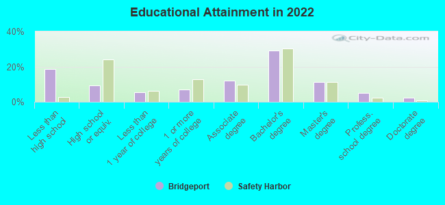
Education in this neighborhood (subdivision or community):
- Percentage of people 3 years and older in K-12 schools:
Bridgeport: 23.0% Safety Harbor: 14.9%
- Percentage of people 3 years and older in undergraduate colleges:
Bridgeport: 1.9% Safety Harbor: 3.0%
- Percentage of people 3 years and older in grad. or professional schools:
Bridgeport: 3.8% Safety Harbor: 0.8%
- Percentage of students K-12 enrolled in private schools:
Bridgeport: 30.9% Safety Harbor: 18.5%
Percentage of population below poverty level:
| Bridgeport: | 4.1% |
| Safety Harbor: | 6.5% |
Median year owner moved in (as recorded in 2022):
| Bridgeport: | 2008 |
| Safety Harbor: | 2009 |
Percentage of married-couple families with both working:
| Bridgeport: | 83.0% |
| Safety Harbor: | 77.9% |
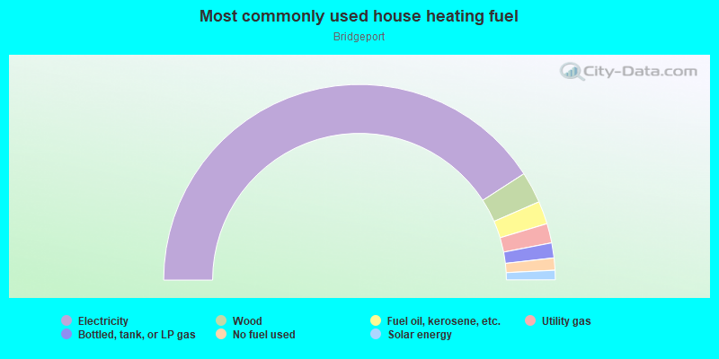
- 81.8%Electricity
- 5.2%Wood
- 3.8%Fuel oil, kerosene, etc.
- 3.2%Utility gas
- 2.5%Bottled, tank, or LP gas
- 2.0%No fuel used
- 1.6%Solar energy
Highways in this neighborhood:
State Hwy 580
Length: 1.39 miles
Directions: E-W, SW-NE
Address range: 2800 to 3599
Directions: E-W, SW-NE
Address range: 2800 to 3599
Phillippe Pkwy (State Hwy 590)
Length: 1.06 miles
Directions: N-S, SE-NW
Address range: 2614 to 3399
Directions: N-S, SE-NW
Address range: 2614 to 3399
State Hwy 586 (Curlew Rd)
Length: 0.17 miles
Direction: E-W
Direction: E-W
N Coast Blvd (Phillippe Pkwy, State Hwy 590)
Length: 0.14 miles
Direction: N-S
Address range: 2500 to 2613
Direction: N-S
Address range: 2500 to 2613
Roads and streets:
Co Rd 611 (N McMullen Booth Rd)
Length: 2.55 miles
Direction: N-S
Address range: 2500 to 3290
Direction: N-S
Address range: 2500 to 3290
Enterprise Rd E (Co Rd 102)
Length: 1.68 miles
Direction: E-W
Address range: 1000 to 3599
Direction: E-W
Address range: 1000 to 3599
N Bay Hills Blvd
Length: 1.24 miles
Directions: E-W, N-S, SE-NW, SW-NE
Address range: 100 to 5099
Directions: E-W, N-S, SE-NW, SW-NE
Address range: 100 to 5099
Diamond Blvd
Length: 0.97 miles
Directions: E-W, N-S, SE-NW, SW-NE
Directions: E-W, N-S, SE-NW, SW-NE
Allen Ave
Length: 0.91 miles
Directions: E-W, SE-NW
Address range: 3100 to 3399
Directions: E-W, SE-NW
Address range: 3100 to 3399
Briar Creek Blvd
Length: 0.74 miles
Directions: E-W, SE-NW, SW-NE
Address range: 1 to 1899
Directions: E-W, SE-NW, SW-NE
Address range: 1 to 1899
2nd St
Length: 0.73 miles
Directions: E-W, N-S
Address range: 3500 to 3502
Directions: E-W, N-S
Address range: 3500 to 3502
Swan Ln
Length: 0.72 miles
Directions: E-W, N-S, SE-NW, SW-NE
Address range: 2000 to 3199
Directions: E-W, N-S, SE-NW, SW-NE
Address range: 2000 to 3199
Egret Ter
Length: 0.62 miles
Directions: E-W, N-S, SW-NE
Address range: 3000 to 3199
Directions: E-W, N-S, SW-NE
Address range: 3000 to 3199
Harbor Woods Cir
Length: 0.61 miles
Directions: E-W, N-S, SE-NW, SW-NE
Address range: 67 to 117
Directions: E-W, N-S, SE-NW, SW-NE
Address range: 67 to 117
Rigsby Ln
Length: 0.50 miles
Direction: N-S
Address range: 2701 to 3198
Direction: N-S
Address range: 2701 to 3198
Bishop Creek Dr
Length: 0.49 miles
Directions: E-W, N-S, SE-NW, SW-NE
Address range: 1 to 55
Directions: E-W, N-S, SE-NW, SW-NE
Address range: 1 to 55
Fairview St
Length: 0.48 miles
Direction: E-W
Address range: 3000 to 3699
Direction: E-W
Address range: 3000 to 3699
Kendale Dr
Length: 0.48 miles
Directions: E-W, N-S, SE-NW, SW-NE
Address range: 100 to 171
Directions: E-W, N-S, SE-NW, SW-NE
Address range: 100 to 171
Country Villas Dr
Length: 0.47 miles
Direction: N-S
Direction: N-S
Valencia Cir
Length: 0.46 miles
Directions: E-W, N-S, SE-NW, SW-NE
Address range: 1 to 61
Directions: E-W, N-S, SE-NW, SW-NE
Address range: 1 to 61
Hillside Ln
Length: 0.46 miles
Directions: E-W, N-S, SE-NW
Address range: 3068 to 3141
Directions: E-W, N-S, SE-NW
Address range: 3068 to 3141
Clubview Dr
Length: 0.45 miles
Directions: E-W, N-S, SE-NW, SW-NE
Address range: 101 to 199
Directions: E-W, N-S, SE-NW, SW-NE
Address range: 101 to 199
Turnstone Dr
Length: 0.41 miles
Directions: E-W, N-S, SW-NE
Address range: 15 to 73
Directions: E-W, N-S, SW-NE
Address range: 15 to 73
Shore Dr
Length: 0.40 miles
Directions: E-W, N-S, SE-NW
Address range: 2800 to 3599
Directions: E-W, N-S, SE-NW
Address range: 2800 to 3599
Ruby Cir
Length: 0.38 miles
Directions: E-W, N-S, SE-NW, SW-NE
Directions: E-W, N-S, SE-NW, SW-NE
Blue Heron St
Length: 0.38 miles
Direction: E-W
Address range: 3101 to 3125
Direction: E-W
Address range: 3101 to 3125
Tall Pine Dr
Length: 0.38 miles
Directions: E-W, N-S, SW-NE
Address range: 3000 to 3046
Directions: E-W, N-S, SW-NE
Address range: 3000 to 3046
Mallard Dr
Length: 0.38 miles
Directions: E-W, N-S, SE-NW
Address range: 3200 to 4199
Directions: E-W, N-S, SE-NW
Address range: 3200 to 4199
Bridgeport Dr
Length: 0.35 miles
Direction: N-S
Address range: 602 to 5099
Direction: N-S
Address range: 602 to 5099
Highland Woods Dr
Length: 0.34 miles
Directions: E-W, N-S, SE-NW
Address range: 200 to 236
Directions: E-W, N-S, SE-NW
Address range: 200 to 236
Harget Ln
Length: 0.34 miles
Directions: N-S, SW-NE
Address range: 3000 to 3002
Directions: N-S, SW-NE
Address range: 3000 to 3002
Mease Dr
Length: 0.33 miles
Directions: E-W, SW-NE
Address range: 1800 to 1899
Directions: E-W, SW-NE
Address range: 1800 to 1899
Teal Ter
Length: 0.33 miles
Directions: E-W, N-S, SW-NE
Address range: 3100 to 3199
Directions: E-W, N-S, SW-NE
Address range: 3100 to 3199
Crane Dr
Length: 0.32 miles
Directions: E-W, N-S, SE-NW, SW-NE
Address range: 29 to 3099
Directions: E-W, N-S, SE-NW, SW-NE
Address range: 29 to 3099
Briarwood Ln
Length: 0.32 miles
Directions: N-S, SE-NW
Address range: 3300 to 3499
Directions: N-S, SE-NW
Address range: 3300 to 3499
Sugar Bear Dr
Length: 0.31 miles
Directions: N-S, SE-NW, SW-NE
Address range: 1 to 199
Directions: N-S, SE-NW, SW-NE
Address range: 1 to 199
Walker Rd
Length: 0.31 miles
Direction: E-W
Address range: 400 to 699
Direction: E-W
Address range: 400 to 699
Widgeon Ave
Length: 0.31 miles
Direction: N-S
Address range: 2000 to 2299
Direction: N-S
Address range: 2000 to 2299
Oak Crest Dr
Length: 0.31 miles
Directions: E-W, SW-NE
Address range: 112 to 319
Directions: E-W, SW-NE
Address range: 112 to 319
Mil-Ray Dr
Length: 0.31 miles
Directions: E-W, N-S
Address range: 3311 to 3313
Directions: E-W, N-S
Address range: 3311 to 3313
Tall Pine Cir
Length: 0.30 miles
Directions: E-W, N-S, SE-NW, SW-NE
Address range: 1700 to 1747
Directions: E-W, N-S, SE-NW, SW-NE
Address range: 1700 to 1747
Pelican Pl
Length: 0.30 miles
Directions: E-W, N-S, SE-NW, SW-NE
Address range: 1100 to 1144
Directions: E-W, N-S, SE-NW, SW-NE
Address range: 1100 to 1144
Pine Hill Dr
Length: 0.29 miles
Direction: E-W
Address range: 1800 to 1828
Direction: E-W
Address range: 1800 to 1828
Humphries Rd
Length: 0.29 miles
Direction: E-W
Address range: 500 to 599
Direction: E-W
Address range: 500 to 599
Rainbow Farms Dr
Length: 0.28 miles
Directions: E-W, N-S, SE-NW, SW-NE
Address range: 2000 to 2098
Directions: E-W, N-S, SE-NW, SW-NE
Address range: 2000 to 2098
4th St
Length: 0.28 miles
Directions: E-W, N-S, SE-NW
Directions: E-W, N-S, SE-NW
Summit Ln
Length: 0.27 miles
Directions: E-W, N-S
Address range: 1 to 38
Directions: E-W, N-S
Address range: 1 to 38
Flamingo Pl
Length: 0.27 miles
Directions: E-W, N-S, SE-NW, SW-NE
Address range: 75 to 2198
Directions: E-W, N-S, SE-NW, SW-NE
Address range: 75 to 2198
Cottagewood Dr
Length: 0.27 miles
Directions: E-W, N-S, SE-NW, SW-NE
Address range: 54 to 99
Directions: E-W, N-S, SE-NW, SW-NE
Address range: 54 to 99
Pinewood Cir
Length: 0.26 miles
Directions: E-W, N-S, SE-NW
Address range: 1 to 199
Directions: E-W, N-S, SE-NW
Address range: 1 to 199
Briarwood Cir
Length: 0.26 miles
Directions: E-W, N-S, SE-NW, SW-NE
Address range: 3300 to 3399
Directions: E-W, N-S, SE-NW, SW-NE
Address range: 3300 to 3399
Coventry N
Length: 0.26 miles
Direction: E-W
Address range: 3200 to 3299
Direction: E-W
Address range: 3200 to 3299
Bay Woods Dr
Length: 0.25 miles
Directions: E-W, N-S, SW-NE
Address range: 57 to 199
Directions: E-W, N-S, SW-NE
Address range: 57 to 199
3rd St
Length: 0.25 miles
Direction: N-S
Direction: N-S
Beechwood Dr
Length: 0.24 miles
Direction: E-W
Address range: 100 to 174
Direction: E-W
Address range: 100 to 174
Harbor Side Dr
Length: 0.24 miles
Directions: E-W, N-S, SE-NW
Address range: 200 to 299
Directions: E-W, N-S, SE-NW
Address range: 200 to 299
Meadowcross Dr
Length: 0.23 miles
Direction: E-W
Address range: 100 to 299
Direction: E-W
Address range: 100 to 299
Hillcrest Dr
Length: 0.23 miles
Direction: E-W
Address range: 100 to 299
Direction: E-W
Address range: 100 to 299
Harbor Woods Dr
Length: 0.23 miles
Directions: N-S, SE-NW
Address range: 1 to 20
Directions: N-S, SE-NW
Address range: 1 to 20
Key Harbor Dr
Length: 0.22 miles
Directions: N-S, SE-NW
Address range: 3000 to 3099
Directions: N-S, SE-NW
Address range: 3000 to 3099
1st St
Length: 0.22 miles
Directions: E-W, N-S, SW-NE
Directions: E-W, N-S, SW-NE
Pinewood Ter
Length: 0.22 miles
Direction: E-W
Address range: 100 to 198
Direction: E-W
Address range: 100 to 198
Crystal Dr
Length: 0.22 miles
Direction: E-W
Direction: E-W
Village Ln
Length: 0.21 miles
Direction: E-W
Address range: 48 to 52
Direction: E-W
Address range: 48 to 52
Parrish Ln
Length: 0.21 miles
Direction: N-S
Address range: 5000 to 5009
Direction: N-S
Address range: 5000 to 5009
Bayview Dr
Length: 0.20 miles
Direction: N-S
Address range: 200 to 2999
Direction: N-S
Address range: 200 to 2999
Signature Ter
Length: 0.19 miles
Directions: E-W, N-S, SE-NW
Address range: 300 to 399
Directions: E-W, N-S, SE-NW
Address range: 300 to 399
Coventry Ln
Length: 0.19 miles
Directions: E-W, N-S, SE-NW
Address range: 3100 to 3126
Directions: E-W, N-S, SE-NW
Address range: 3100 to 3126
Timberview Dr
Length: 0.19 miles
Direction: E-W
Address range: 100 to 299
Direction: E-W
Address range: 100 to 299
Nestlebranch Dr
Length: 0.19 miles
Direction: E-W
Address range: 100 to 299
Direction: E-W
Address range: 100 to 299
Woodland Ct
Length: 0.17 miles
Directions: E-W, SW-NE
Address range: 115 to 318
Directions: E-W, SW-NE
Address range: 115 to 318
Sugar Bear Ct
Length: 0.17 miles
Directions: N-S, SW-NE
Address range: 29 to 80
Directions: N-S, SW-NE
Address range: 29 to 80
Coventry E
Length: 0.16 miles
Direction: N-S
Address range: 3100 to 3123
Direction: N-S
Address range: 3100 to 3123
Hickory Ln
Length: 0.16 miles
Direction: E-W
Address range: 20 to 41
Direction: E-W
Address range: 20 to 41
Cedar Elm Dr
Length: 0.16 miles
Direction: N-S
Address range: 1 to 116
Direction: N-S
Address range: 1 to 116
Wateredge Ct
Length: 0.16 miles
Direction: E-W
Address range: 100 to 199
Direction: E-W
Address range: 100 to 199
Birch Creek Dr
Length: 0.15 miles
Directions: N-S, SW-NE
Address range: 1 to 99
Directions: N-S, SW-NE
Address range: 1 to 99
Gull Ln
Length: 0.15 miles
Directions: E-W, SE-NW
Address range: 2100 to 2199
Directions: E-W, SE-NW
Address range: 2100 to 2199
State Rte 590
Length: 0.15 miles
Directions: E-W, N-S, SE-NW
Directions: E-W, N-S, SE-NW
Topaz Ct
Length: 0.14 miles
Direction: E-W
Direction: E-W
Jade Dr
Length: 0.14 miles
Direction: E-W
Direction: E-W
Opal Ln
Length: 0.14 miles
Direction: E-W
Direction: E-W
Pearl Pl
Length: 0.14 miles
Direction: E-W
Direction: E-W
Lotus Dr
Length: 0.14 miles
Direction: E-W
Address range: 200 to 250
Direction: E-W
Address range: 200 to 250
Emerald Dr
Length: 0.13 miles
Direction: N-S
Direction: N-S
Bermuda Ct
Length: 0.13 miles
Direction: E-W
Address range: 1700 to 1799
Direction: E-W
Address range: 1700 to 1799
Idlewilde Dr
Length: 0.12 miles
Direction: N-S
Address range: 1 to 18
Direction: N-S
Address range: 1 to 18
Glenwood Ct
Length: 0.12 miles
Direction: N-S
Address range: 3045 to 3199
Direction: N-S
Address range: 3045 to 3199
Briarwood Pl
Length: 0.11 miles
Direction: N-S
Address range: 87 to 109
Direction: N-S
Address range: 87 to 109
Natures Trl
Length: 0.11 miles
Direction: N-S
Direction: N-S
Coral Ln
Length: 0.11 miles
Direction: E-W
Direction: E-W
Juniperus Dr
Length: 0.10 miles
Direction: E-W
Address range: 1 to 199
Direction: E-W
Address range: 1 to 199
Silver Fox Dr
Length: 0.10 miles
Direction: E-W
Address range: 100 to 133
Direction: E-W
Address range: 100 to 133
Sandpipper Ln
Length: 0.10 miles
Directions: E-W, SW-NE
Address range: 3100 to 3199
Directions: E-W, SW-NE
Address range: 3100 to 3199
Garnet Ln
Length: 0.10 miles
Directions: N-S, SE-NW
Directions: N-S, SE-NW
Highway To Bay Blvd (Hi Way To Bay Blvd)
Length: 0.10 miles
Direction: E-W
Address range: 101 to 3577
Direction: E-W
Address range: 101 to 3577
Hickory Branch Ln
Length: 0.10 miles
Direction: N-S
Address range: 2 to 99
Direction: N-S
Address range: 2 to 99
Bishop Dr
Length: 0.10 miles
Directions: N-S, SE-NW
Address range: 3100 to 3199
Directions: N-S, SE-NW
Address range: 3100 to 3199
Kevlyn Ct
Length: 0.10 miles
Direction: N-S
Address range: 3000 to 3199
Direction: N-S
Address range: 3000 to 3199
Villa Ct
Length: 0.10 miles
Directions: E-W, SE-NW
Address range: 1 to 18
Directions: E-W, SE-NW
Address range: 1 to 18
Rainbow Ct
Length: 0.10 miles
Direction: N-S
Address range: 3024 to 3049
Direction: N-S
Address range: 3024 to 3049
Redwood Dr
Length: 0.10 miles
Direction: N-S
Address range: 2 to 99
Direction: N-S
Address range: 2 to 99
Jacaranda Dr
Length: 0.10 miles
Direction: N-S
Address range: 2 to 99
Direction: N-S
Address range: 2 to 99
Lotus Cir
Length: 0.10 miles
Direction: E-W
Address range: 100 to 244
Direction: E-W
Address range: 100 to 244
Chestnut Cir
Length: 0.09 miles
Direction: E-W
Address range: 100 to 199
Direction: E-W
Address range: 100 to 199
Forest Cir
Length: 0.09 miles
Direction: E-W
Address range: 100 to 199
Direction: E-W
Address range: 100 to 199
Peacock Cir
Length: 0.09 miles
Direction: E-W
Address range: 100 to 199
Direction: E-W
Address range: 100 to 199
Forest Ln
Length: 0.09 miles
Direction: E-W
Address range: 1 to 147
Direction: E-W
Address range: 1 to 147
Timber Cir
Length: 0.09 miles
Direction: E-W
Address range: 100 to 199
Direction: E-W
Address range: 100 to 199
Cypress Dr
Length: 0.09 miles
Direction: N-S
Address range: 72 to 99
Direction: N-S
Address range: 72 to 99
la Playa Ct
Length: 0.09 miles
Directions: E-W, SW-NE
Address range: 6000 to 6099
Directions: E-W, SW-NE
Address range: 6000 to 6099
Jasmine Cir
Length: 0.09 miles
Direction: E-W
Address range: 100 to 199
Direction: E-W
Address range: 100 to 199
Woodburn Ct
Length: 0.09 miles
Direction: E-W
Address range: 100 to 399
Direction: E-W
Address range: 100 to 399
Clearview Dr
Length: 0.09 miles
Direction: N-S
Address range: 1 to 19
Direction: N-S
Address range: 1 to 19
Vinewood Dr
Length: 0.09 miles
Direction: E-W
Address range: 1 to 148
Direction: E-W
Address range: 1 to 148
Dominion Ct
Length: 0.08 miles
Direction: N-S
Address range: 3009 to 3199
Direction: N-S
Address range: 3009 to 3199
Red Fox Run
Length: 0.08 miles
Direction: N-S
Address range: 2 to 98
Direction: N-S
Address range: 2 to 98
del Sol Ct
Length: 0.08 miles
Direction: N-S
Address range: 600 to 699
Direction: N-S
Address range: 600 to 699
Avocet Pl
Length: 0.08 miles
Directions: E-W, SW-NE
Address range: 3100 to 3199
Directions: E-W, SW-NE
Address range: 3100 to 3199
Chestnut Dr
Length: 0.08 miles
Direction: N-S
Address range: 2 to 99
Direction: N-S
Address range: 2 to 99
Muellers Ln
Length: 0.08 miles
Direction: N-S
Address range: 5021 to 5034
Direction: N-S
Address range: 5021 to 5034
Ashwood Ln
Length: 0.07 miles
Direction: N-S
Address range: 3100 to 3199
Direction: N-S
Address range: 3100 to 3199
Deer Trail Ct
Length: 0.07 miles
Direction: SE-NW
Address range: 1 to 99
Direction: SE-NW
Address range: 1 to 99
Brentwood Ln
Length: 0.07 miles
Direction: N-S
Address range: 3100 to 3199
Direction: N-S
Address range: 3100 to 3199
Honey Bear Ct
Length: 0.07 miles
Directions: E-W, SE-NW
Address range: 1 to 99
Directions: E-W, SE-NW
Address range: 1 to 99
Laurelwood Dr
Length: 0.07 miles
Direction: N-S
Address range: 2 to 99
Direction: N-S
Address range: 2 to 99
Osprey St
Length: 0.07 miles
Direction: N-S
Address range: 29 to 43
Direction: N-S
Address range: 29 to 43
Mar Bay Ln
Length: 0.07 miles
Direction: E-W
Address range: 2 to 12
Direction: E-W
Address range: 2 to 12
New Fawn Ct
Length: 0.07 miles
Direction: SE-NW
Address range: 1 to 99
Direction: SE-NW
Address range: 1 to 99
Rainbow
Length: 0.07 miles
Direction: E-W
Direction: E-W
Pine Creek Ct
Length: 0.07 miles
Direction: E-W
Address range: 1700 to 1799
Direction: E-W
Address range: 1700 to 1799
Thistle Briar Dr
Length: 0.06 miles
Direction: N-S
Address range: 1 to 199
Direction: N-S
Address range: 1 to 199
Briarwood Ct
Length: 0.06 miles
Directions: E-W, SW-NE
Address range: 1400 to 1499
Directions: E-W, SW-NE
Address range: 1400 to 1499
Tern Cove
Length: 0.06 miles
Direction: E-W
Address range: 1 to 99
Direction: E-W
Address range: 1 to 99
Old Oak Ln
Length: 0.06 miles
Direction: N-S
Address range: 2000 to 2020
Direction: N-S
Address range: 2000 to 2020
Brookside Dr
Length: 0.06 miles
Directions: E-W, N-S, SE-NW
Address range: 2001 to 2065
Directions: E-W, N-S, SE-NW
Address range: 2001 to 2065
Beaver Dam Ct
Length: 0.06 miles
Directions: E-W, SE-NW
Address range: 1 to 99
Directions: E-W, SE-NW
Address range: 1 to 99
1st Ave N
Length: 0.06 miles
Direction: N-S
Address range: 2500 to 2599
Direction: N-S
Address range: 2500 to 2599
Pintail Pl
Length: 0.06 miles
Direction: E-W
Address range: 1 to 99
Direction: E-W
Address range: 1 to 99
Pine Hill Ct
Length: 0.06 miles
Direction: E-W
Address range: 1700 to 1799
Direction: E-W
Address range: 1700 to 1799
Widgeon Pl
Length: 0.06 miles
Directions: E-W, SE-NW
Address range: 1 to 99
Directions: E-W, SE-NW
Address range: 1 to 99
Honeysuckle Ct
Length: 0.06 miles
Directions: N-S, SE-NW
Address range: 27 to 45
Directions: N-S, SE-NW
Address range: 27 to 45
Westbrook Ct
Length: 0.06 miles
Direction: E-W
Address range: 100 to 199
Direction: E-W
Address range: 100 to 199
Stag Run Ct
Length: 0.05 miles
Directions: E-W, SE-NW
Directions: E-W, SE-NW
Bridgeport Ct
Length: 0.05 miles
Direction: E-W
Address range: 600 to 5031
Direction: E-W
Address range: 600 to 5031
Copperwood Ct
Length: 0.05 miles
Direction: E-W
Direction: E-W
Royal Ct
Length: 0.05 miles
Direction: SW-NE
Address range: 100 to 199
Direction: SW-NE
Address range: 100 to 199
Kingfisher Cove
Length: 0.05 miles
Directions: E-W, N-S, SE-NW
Directions: E-W, N-S, SE-NW
Mandarin Ter
Length: 0.05 miles
Direction: E-W
Address range: 1 to 11
Direction: E-W
Address range: 1 to 11
Ibis Cir
Length: 0.05 miles
Direction: E-W
Address range: 1 to 99
Direction: E-W
Address range: 1 to 99
Dogwood Ct
Length: 0.05 miles
Directions: E-W, SE-NW
Directions: E-W, SE-NW
Willow Creek Ct
Length: 0.04 miles
Directions: N-S, SE-NW, SW-NE
Address range: 1 to 99
Directions: N-S, SE-NW, SW-NE
Address range: 1 to 99
Heron Cove
Length: 0.04 miles
Direction: N-S
Address range: 1 to 18
Direction: N-S
Address range: 1 to 18
Bayview St
Length: 0.04 miles
Direction: E-W
Direction: E-W
Bayhill Ct
Length: 0.04 miles
Direction: E-W
Address range: 1 to 11
Direction: E-W
Address range: 1 to 11
Oakleaf Ct
Length: 0.04 miles
Direction: E-W
Direction: E-W
N Flamingo Pl
Length: 0.04 miles
Direction: N-S
Address range: 2100 to 2121
Direction: N-S
Address range: 2100 to 2121
Scoter Cove
Length: 0.04 miles
Direction: N-S
Address range: 1 to 19
Direction: N-S
Address range: 1 to 19
Bayshore Dr
Length: 0.04 miles
Direction: N-S
Address range: 2874 to 2898
Direction: N-S
Address range: 2874 to 2898
Tangelo Ter
Length: 0.04 miles
Direction: SW-NE
Address range: 1 to 99
Direction: SW-NE
Address range: 1 to 99
Bear Run Ct
Length: 0.04 miles
Directions: E-W, SE-NW
Address range: 1 to 99
Directions: E-W, SE-NW
Address range: 1 to 99
Live Oak Ct
Length: 0.03 miles
Direction: N-S
Address range: 1 to 99
Direction: N-S
Address range: 1 to 99
Shady Oak Ct
Length: 0.03 miles
Directions: N-S, SE-NW
Directions: N-S, SE-NW
Hillside Ln E
Length: 0.03 miles
Direction: E-W
Direction: E-W
Flamingo Cir
Length: 0.03 miles
Direction: SW-NE
Address range: 1 to 2104
Direction: SW-NE
Address range: 1 to 2104
Turtle Creek Ct
Length: 0.03 miles
Direction: SE-NW
Address range: 1 to 99
Direction: SE-NW
Address range: 1 to 99
Enterprise Rd (Co Rd 102)
Length: 0.03 miles
Direction: E-W
Address range: 3536 to 3698
Direction: E-W
Address range: 3536 to 3698
Onyx Ln
Length: 0.03 miles
Direction: N-S
Direction: N-S
Sunrise Ct
Length: 0.03 miles
Direction: E-W
Address range: 1 to 99
Direction: E-W
Address range: 1 to 99
Signature Ct
Length: 0.03 miles
Direction: SW-NE
Address range: 300 to 312
Direction: SW-NE
Address range: 300 to 312
Oak Creek Dr N
Length: 0.03 miles
Direction: E-W
Direction: E-W
Crane Ct
Length: 0.02 miles
Direction: SE-NW
Address range: 1 to 99
Direction: SE-NW
Address range: 1 to 99
Tanglewood Dr
Length: 0.02 miles
Direction: E-W
Direction: E-W
Magnolia Ct
Length: 0.02 miles
Direction: SW-NE
Direction: SW-NE
Railroad features:
Csx RR (Amtrak RR)
Length: 1.34 miles
Direction: N-S
Direction: N-S
Other features:
Bishop Crk
Length: 2.29 miles
Directions: E-W, N-S, SE-NW, SW-NE
Directions: E-W, N-S, SE-NW, SW-NE
Possum Br
Length: 0.59 miles
Directions: E-W, N-S, SW-NE
Directions: E-W, N-S, SW-NE
Briar Crk
Length: 0.32 miles
Directions: E-W, SE-NW, SW-NE
Directions: E-W, SE-NW, SW-NE
Other features:
Atlantic Ocean
Length: 0.01 miles
Direction: SW-NE
Direction: SW-NE