Creston neighborhood in Grand Rapids, Michigan (MI), 49505 detailed profile
Settings
X


Business Search - 14 Million verified businesses
Area: 2.450 square miles
Population: 10,321
Population density:
| Creston: | 4,213 people per square mile |
| Grand Rapids: | 4,411 people per square mile |

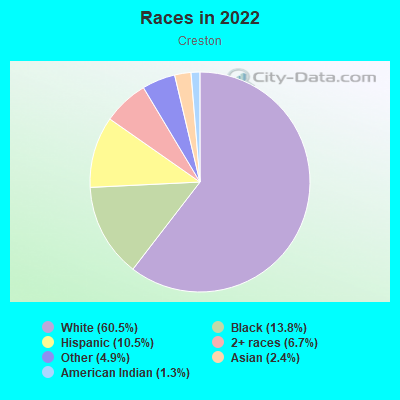
- 6,90260.5%White
- 1,56913.8%Black
- 1,20010.5%Hispanic or Latino
- 7606.7%Two or more races
- 5574.9%Some other race
- 2692.4%Asian
- 1491.3%American Indian
Median household income in 2022:
| Creston: | $68,609 |
| Grand Rapids: | $65,660 |
Distribution of median household income
![Distribution of median household income]()
- 355Less than $10,000
- 447$10,000 to $19,999
- 386$20,000 to $29,999
- 678$30,000 to $39,999
- 690$40,000 to $49,999
- 529$50,000 to $59,999
- 355$60,000 to $74,999
- 770$75,000 to $99,999
- 473$100,000 to $124,999
- 348$125,000 to $149,999
- 208$150,000 to $199,999
- 174$200,000 or more

Distribution of owner-occupied house/condo value
![Distribution of owner-occupied house/condo value]()
- 718Less than $50,000
- 916$50,000 to $99,999
- 612$100,000 to $149,999
- 788$150,000 to $199,999
- 756$200,000 to $249,999
- 329$250,000 to $299,999
- 262$300,000 to $399,999
- 240$400,000 to $499,999
- 123$500,000 to $749,999
- 259$1,000,000 or more

Distribution of rent paid by renters
![Distribution of rent paid by renters]()
- 71Less than $100
- 339$100 to $199
- 95$200 to $299
- 449$300 to $399
- 609$400 to $499
- 254$500 to $599
- 412$600 to $699
- 694$700 to $799
- 472$800 to $899
- 285$900 to $999
- 629$1,000 to $1,249
- 336$1,250 to $1,499
- 313$1,500 to $1,999
- 359$2,000 or more

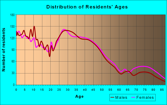
| Males: | 5,272 |
| Females: | 5,048 |
Males:
| This neighborhood: | 36.5 years |
| Whole city: | 33.0 years |
| This neighborhood: | 34.7 years |
| Whole city: | 33.3 years |
Average household size:
| Creston: | 3.6 people |
| Grand Rapids: | 2.2 people |
Percentage of family households:
| Creston: | 47.9% |
| Grand Rapids: | 36.8% |
| Here: | 34.9% |
| Grand Rapids: | 31.2% |
Percentage of married-couple families with children (among all households):
| Creston: | 24.8% |
| Grand Rapids: | 25.1% |
Percentage of single-mother households (among all households):
| Creston: | 16.0% |
| Grand Rapids: | 14.6% |
Percentage of never married males 15 years old and over:
Percentage of never married females 15 years old and over:
| Creston: | 25.4% |
| Grand Rapids: | 23.6% |
Percentage of never married females 15 years old and over:
| Creston: | 18.6% |
| city: | 23.9% |
Percentage of people that speak English not well or not at all:
| Creston: | 1.5% |
| Grand Rapids: | 4.2% |
Percentage of people born in this state:
Percentage of people born in another U.S. state:
Percentage of native residents but born outside the U.S.:
Percentage of foreign born residents:
| Here: | 75.0% |
| Grand Rapids: | 70.1% |
Percentage of people born in another U.S. state:
| Creston: | 16.5% |
| Grand Rapids: | 18.1% |
Percentage of native residents but born outside the U.S.:
| Here: | 0.7% |
| city: | 1.0% |
Percentage of foreign born residents:
| Here: | 7.7% |
| Grand Rapids: | 10.8% |
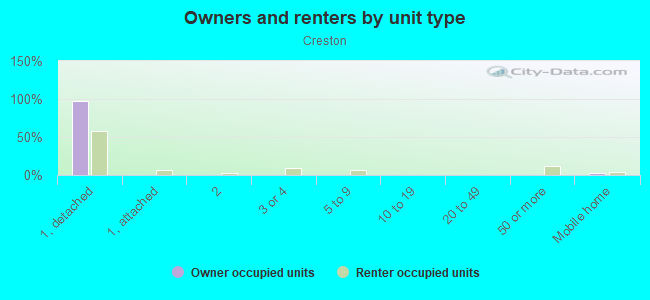
Owner-occupied
Renter-occupied

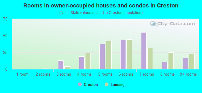
- Rooms in owner-occupied houses and condos in Creston
- 2271 room
- 312 rooms
- 1893 rooms
- 1144 rooms
- 4885 rooms
- 7106 rooms
- 5217 rooms
- 4438 rooms
- 4959+ rooms
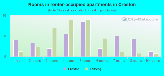
- Rooms in renter-occupied apartments in Creston
- 491 room
- 892 rooms
- 4413 rooms
- 1,0724 rooms
- 3445 rooms
- 4566 rooms
- 5367 rooms
- 1508 rooms
- 1259+ rooms
Owner-occupied
Renter-occupied
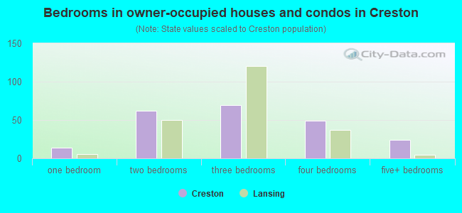
- Bedrooms in owner-occupied houses and condos in Creston
- 227no bedroom
- 571 bedroom
- 5222 bedrooms
- 1,6433 bedrooms
- 4444 bedrooms
- 2965+ bedrooms
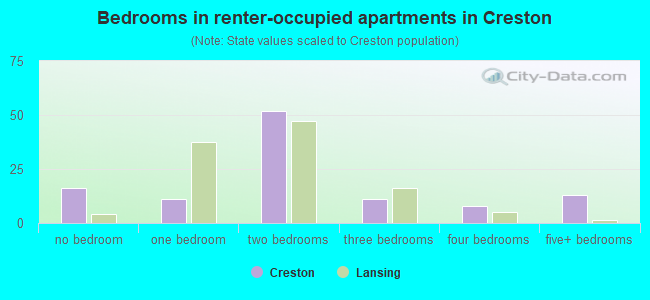
- Bedrooms in renter-occupied apartments in Creston
- 49no bedroom
- 5311 bedroom
- 5842 bedrooms
- 6573 bedrooms
- 2094 bedrooms
- 1415+ bedrooms
Average number of cars or other vehicles available in houses/condos:
Average number of cars or other vehicles available in apartments:
| This neighborhood: | 1.7 |
| Grand Rapids: | 1.8 |
Average number of cars or other vehicles available in apartments:
| Here: | |
| city: |
Percentage of units with a mortgage:
| Creston: | 67.8% |
| Grand Rapids: | 67.2% |
Average estimated value of detached houses in 2022 (74.7% of all units):
| Creston: | $219,929 |
| Grand Rapids: | $216,026 |
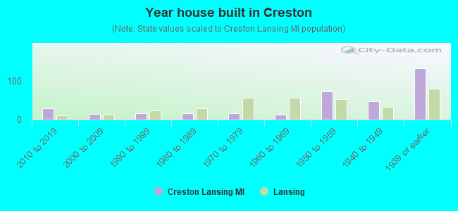
- Year house built in Creston
- 02020 or later
- 3772010 to 2019
- 3732000 to 2009
- 891990 to 1999
- 2241980 to 1989
- 1521970 to 1979
- 4811960 to 1969
- 1,0621950 to 1959
- 6431940 to 1949
- 1,9511939 or earlier
City-data.com crime index for city in 2020 (higher means more crime):
| City: | 309.2 |
| U.S. average: | 219.5 |
Travel time to work (commute)
![Travel time to work (commute)]()
- 88Less than 5 minutes
- 5745 to 9 minutes
- 1,01310 to 14 minutes
- 1,18815 to 19 minutes
- 79920 to 24 minutes
- 32625 to 29 minutes
- 44630 to 34 minutes
- 9735 to 39 minutes
- 5740 to 44 minutes
- 24745 to 59 minutes
- 10560 to 89 minutes
- 4090 or more minutes

Means of transportation to work
![Means of transportation to work]()
- 75.1%4,129Drove a car alone
- 11.6%638Carpooled
- 5.6%310Bus
- 3.1%171Taxi
- 0.5%29Motorcycle
- 2.0%112Bicycle
- 4.8%266Walked
- 7.1%389Other means
- 10.2%563Worked at home

Time leaving home to go to work
![Time leaving home to go to work]()
- 34212:00 a.m. to 4:59 a.m.
- 1285:00 a.m. to 5:29 a.m.
- 2325:30 a.m. to 5:59 a.m.
- 2596:00 a.m. to 6:29 a.m.
- 3036:30 a.m. to 6:59 a.m.
- 6777:00 a.m. to 7:29 a.m.
- 6227:30 a.m. to 7:59 a.m.
- 6508:00 a.m. to 8:29 a.m.
- 2688:30 a.m. to 8:59 a.m.
- 2099:00 a.m. to 9:59 a.m.
- 13610:00 a.m. to 10:59 a.m.
- 14511:00 a.m. to 11:59 a.m.
- 57612:00 p.m. to 3:59 p.m.
- 3784:00 p.m. to 11:59 p.m.

Occupations of males:
- Percentage of males in management occupations (except farmers):
Here: 11.3% city: 10.3%
- Percentage of males in business and financial operations occupations:
Here: 4.1% city: 5.8%
- Percentage of males in computer and mathematical occupations:
Here: 5.7% city: 5.4%
- Percentage of males in architecture and engineering occupations:
Here: 2.3% city: 3.6%
- Percentage of males in life, physical, and social science occupations:
Here: 1.1% city: 0.9%
- Percentage of males in legal occupations:
Here: 1.7% city: 0.9%
- Percentage of males in education, training, and library occupations:
Here: 1.1% city: 3.9%
- Percentage of males in arts, design, entertainment, sports, and media occupations:
Here: 2.0% city: 2.9%
- Percentage of males in healthcare practitioners and technical occupations:
Here: 1.9% city: 3.1%
- Percentage of males in service occupations:
Here: 13.4% city: 14.6%
- Percentage of males in sales and office occupations:
Here: 17.1% city: 14.1%
- Percentage of males in construction, extraction, and maintenance occupations:
Here: 4.5% city: 6.5%
- Percentage of males in production occupations:
Here: 17.6% city: 11.0%
- Percentage of males in transportation occupations:
Here: 3.2% city: 4.2%
- Percentage of males in material moving occupations:
Here: 9.5% city: 7.3%
Occupations of females:
- Percentage of females in management occupations (except farmers):
Here: 6.3% city: 7.9%
- Percentage of females in business and financial operations occupations:
Here: 7.5% city: 6.3%
- Percentage of females in community and social services occupations:
Here: 4.0% city: 2.8%
- Percentage of females in education, training, and library occupations:
Here: 6.0% city: 7.2%
- Percentage of females in arts, design, entertainment, sports, and media occupations:
Here: 2.7% city: 2.7%
- Percentage of females in healthcare practitioners and technical occupations:
Here: 8.1% city: 10.8%
- Percentage of females in service occupations:
Here: 31.2% city: 21.1%
- Percentage of females in sales and office occupations:
Here: 24.4% city: 24.9%
- Percentage of females in production occupations:
Here: 3.3% city: 6.8%
- Percentage of females in transportation occupations:
Here: 1.7% city: 1.3%
- Percentage of females in material moving occupations:
Here: 2.3% city: 2.7%
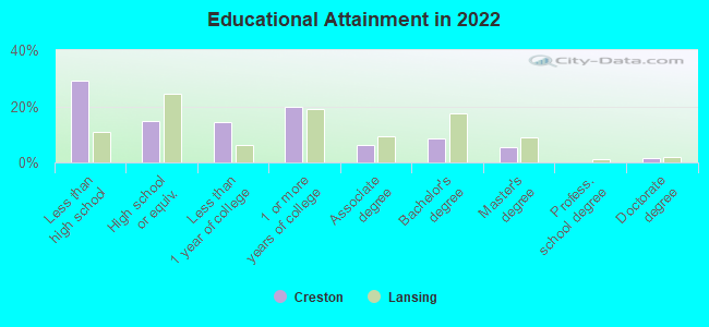
Education in this neighborhood (subdivision or community):
- Percentage of people 3 years and older in K-12 schools:
Creston: 42.0% Grand Rapids: 13.5%
- Percentage of people 3 years and older in undergraduate colleges:
Creston: 5.8% Grand Rapids: 6.0%
- Percentage of people 3 years and older in grad. or professional schools:
Creston: 3.0% Grand Rapids: 2.1%
- Percentage of students K-12 enrolled in private schools:
Creston: 29.7% Grand Rapids: 26.5%
Percentage of population below poverty level:
| Creston: | 16.9% |
| Grand Rapids: | 15.8% |
Median year owner moved in (as recorded in 2022):
| Creston: | 2007 |
| Grand Rapids: | 2012 |
Percentage of married-couple families with both working:
| Creston: | 102.2% |
| Grand Rapids: | 70.8% |
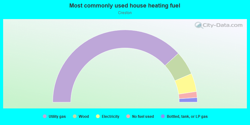
- 82.7%Utility gas
- 8.7%Electricity
- 4.8%Bottled, tank, or LP gas
- 2.5%Wood
- 1.2%Other fuel
Roads and streets:
Knapp St NE
Length: 1.90 miles
Direction: E-W
Address range: 1 to 1157
Direction: E-W
Address range: 1 to 1157
Coit Ave NE
Length: 1.85 miles
Directions: N-S, SW-NE
Address range: 1400 to 2763
Directions: N-S, SW-NE
Address range: 1400 to 2763
Spencer St NE
Length: 1.66 miles
Direction: E-W
Address range: 200 to 3171
Direction: E-W
Address range: 200 to 3171
Monroe Ave NW
Length: 1.46 miles
Direction: N-S
Address range: 1229 to 2399
Direction: N-S
Address range: 1229 to 2399
Lafayette Ave NE
Length: 1.39 miles
Directions: N-S, SE-NW
Address range: 1200 to 2749
Directions: N-S, SE-NW
Address range: 1200 to 2749
Sweet St NE
Length: 1.28 miles
Direction: E-W
Address range: 1 to 1119
Direction: E-W
Address range: 1 to 1119
Plainfield Ave NE
Length: 1.25 miles
Direction: SW-NE
Address range: 1230 to 2029
Direction: SW-NE
Address range: 1230 to 2029
Oakwood Ave NE
Length: 1.19 miles
Directions: N-S, SE-NW
Address range: 1800 to 2745
Directions: N-S, SE-NW
Address range: 1800 to 2745
Russwood St NE
Length: 1.04 miles
Directions: E-W, SW-NE
Address range: 200 to 899
Directions: E-W, SW-NE
Address range: 200 to 899
Sligh Blvd NE
Length: 1.02 miles
Directions: E-W, SE-NW
Address range: 100 to 730
Directions: E-W, SE-NW
Address range: 100 to 730
Diamond Ave NE
Length: 1.00 miles
Direction: N-S
Address range: 1200 to 1999
Direction: N-S
Address range: 1200 to 1999
Quimby St NE
Length: 0.97 miles
Direction: E-W
Address range: 1 to 599
Direction: E-W
Address range: 1 to 599
Page St NE
Length: 0.92 miles
Direction: E-W
Address range: 1 to 1099
Direction: E-W
Address range: 1 to 1099
Graceland St NE
Length: 0.92 miles
Direction: E-W
Address range: 1 to 499
Direction: E-W
Address range: 1 to 499
College Ave NE
Length: 0.88 miles
Directions: E-W, N-S, SE-NW, SW-NE
Address range: 1222 to 2799
Directions: E-W, N-S, SE-NW, SW-NE
Address range: 1222 to 2799
Herrick Ave NE
Length: 0.86 miles
Directions: N-S, SE-NW, SW-NE
Address range: 1200 to 1899
Directions: N-S, SE-NW, SW-NE
Address range: 1200 to 1899
Carrier St NE
Length: 0.85 miles
Direction: E-W
Address range: 100 to 599
Direction: E-W
Address range: 100 to 599
Leonard St NE
Length: 0.82 miles
Direction: E-W
Address range: 641 to 1106
Direction: E-W
Address range: 641 to 1106
Sinclair Ave NE
Length: 0.79 miles
Directions: E-W, N-S, SE-NW, SW-NE
Address range: 2000 to 2737
Directions: E-W, N-S, SE-NW, SW-NE
Address range: 2000 to 2737
Emerald Ave NE
Length: 0.78 miles
Directions: N-S, SW-NE
Address range: 1200 to 1999
Directions: N-S, SW-NE
Address range: 1200 to 1999
Comstock Blvd NE
Length: 0.77 miles
Directions: E-W, N-S, SE-NW
Address range: 200 to 630
Directions: E-W, N-S, SE-NW
Address range: 200 to 630
Houseman Ave NE
Length: 0.76 miles
Directions: N-S, SE-NW
Address range: 1200 to 1999
Directions: N-S, SE-NW
Address range: 1200 to 1999
Foster Ave NE
Length: 0.76 miles
Direction: SW-NE
Address range: 2200 to 2799
Direction: SW-NE
Address range: 2200 to 2799
Union Ave NE
Length: 0.75 miles
Directions: N-S, SW-NE
Address range: 1226 to 2599
Directions: N-S, SW-NE
Address range: 1226 to 2599
Curtis St NE
Length: 0.70 miles
Direction: E-W
Address range: 400 to 899
Direction: E-W
Address range: 400 to 899
Dean St NE
Length: 0.67 miles
Direction: E-W
Address range: 1 to 499
Direction: E-W
Address range: 1 to 499
Eleanor St NE
Length: 0.67 miles
Direction: E-W
Address range: 200 to 599
Direction: E-W
Address range: 200 to 599
Marietta St NE
Length: 0.66 miles
Direction: E-W
Address range: 400 to 799
Direction: E-W
Address range: 400 to 799
Burke Ave NE
Length: 0.66 miles
Directions: E-W, N-S, SE-NW, SW-NE
Address range: 1200 to 1799
Directions: E-W, N-S, SE-NW, SW-NE
Address range: 1200 to 1799
Elmwood St NE
Length: 0.66 miles
Direction: E-W
Address range: 1 to 499
Direction: E-W
Address range: 1 to 499
Riverside Dr NE
Length: 0.65 miles
Directions: E-W, N-S, SW-NE
Address range: 2100 to 2738
Directions: E-W, N-S, SW-NE
Address range: 2100 to 2738
Paris Ave NE
Length: 0.64 miles
Directions: N-S, SW-NE
Address range: 1200 to 2499
Directions: N-S, SW-NE
Address range: 1200 to 2499
Ann St NE
Length: 0.63 miles
Direction: E-W
Address range: 1 to 499
Direction: E-W
Address range: 1 to 499
Palmer St NE
Length: 0.59 miles
Direction: E-W
Address range: 1 to 399
Direction: E-W
Address range: 1 to 399
Cheshire Dr NE
Length: 0.54 miles
Directions: E-W, SE-NW, SW-NE
Address range: 300 to 2499
Directions: E-W, SE-NW, SW-NE
Address range: 300 to 2499
Dale St NE
Length: 0.51 miles
Direction: E-W
Address range: 1 to 399
Direction: E-W
Address range: 1 to 399
Washtenaw Dr NE
Length: 0.51 miles
Directions: E-W, SE-NW, SW-NE
Address range: 800 to 1099
Directions: E-W, SE-NW, SW-NE
Address range: 800 to 1099
Cusick Pl NW
Length: 0.50 miles
Direction: N-S
Address range: 1600 to 1999
Direction: N-S
Address range: 1600 to 1999
Center Ave NE
Length: 0.50 miles
Direction: N-S
Address range: 1600 to 1999
Direction: N-S
Address range: 1600 to 1999
Swensberg Ave NE
Length: 0.47 miles
Direction: N-S
Address range: 2000 to 2399
Direction: N-S
Address range: 2000 to 2399
Kent Hills Rd NE
Length: 0.46 miles
Direction: E-W
Address range: 500 to 799
Direction: E-W
Address range: 500 to 799
Boltwood Dr NE
Length: 0.45 miles
Direction: E-W
Address range: 1 to 399
Direction: E-W
Address range: 1 to 399
Monroe Ave NE
Length: 0.45 miles
Directions: N-S, SW-NE
Address range: 2400 to 2699
Directions: N-S, SW-NE
Address range: 2400 to 2699
Burr Oak St NE
Length: 0.45 miles
Direction: E-W
Address range: 1 to 299
Direction: E-W
Address range: 1 to 299
Travis St NE
Length: 0.44 miles
Direction: E-W
Address range: 1 to 299
Direction: E-W
Address range: 1 to 299
North Ave NE
Length: 0.44 miles
Direction: N-S
Address range: 1227 to 1599
Direction: N-S
Address range: 1227 to 1599
Taylor Ave N
Length: 0.44 miles
Direction: N-S
Address range: 1230 to 1599
Direction: N-S
Address range: 1230 to 1599
Borglum Ave NE
Length: 0.42 miles
Directions: N-S, SW-NE
Address range: 2400 to 2699
Directions: N-S, SW-NE
Address range: 2400 to 2699
Marywood Dr NE
Length: 0.41 miles
Directions: E-W, SE-NW
Address range: 400 to 603
Directions: E-W, SE-NW
Address range: 400 to 603
Country Club Dr NE
Length: 0.38 miles
Directions: E-W, N-S, SE-NW
Address range: 1600 to 1799
Directions: E-W, N-S, SE-NW
Address range: 1600 to 1799
Prospect Ave NE
Length: 0.37 miles
Direction: N-S
Address range: 2000 to 2299
Direction: N-S
Address range: 2000 to 2299
Kentwood Dr NE
Length: 0.37 miles
Directions: E-W, SW-NE
Address range: 900 to 1119
Directions: E-W, SW-NE
Address range: 900 to 1119
Brenner St NE
Length: 0.34 miles
Direction: E-W
Address range: 400 to 599
Direction: E-W
Address range: 400 to 599
Conger St NE
Length: 0.32 miles
Directions: E-W, SW-NE
Address range: 600 to 899
Directions: E-W, SW-NE
Address range: 600 to 899
Rehoboth St NE
Length: 0.31 miles
Direction: E-W
Address range: 600 to 799
Direction: E-W
Address range: 600 to 799
Grove St NE
Length: 0.31 miles
Direction: E-W
Address range: 1 to 199
Direction: E-W
Address range: 1 to 199
Colfax St NE
Length: 0.29 miles
Direction: E-W
Address range: 1 to 199
Direction: E-W
Address range: 1 to 199
Mathews Ct NE
Length: 0.29 miles
Direction: E-W
Address range: 1 to 199
Direction: E-W
Address range: 1 to 199
Katherine Dr NE
Length: 0.28 miles
Directions: E-W, SW-NE
Address range: 1 to 199
Directions: E-W, SW-NE
Address range: 1 to 199
Portland Ave NE
Length: 0.28 miles
Direction: N-S
Address range: 1200 to 13141
Direction: N-S
Address range: 1200 to 13141
Penn Ave NE
Length: 0.28 miles
Direction: N-S
Address range: 1200 to 1399
Direction: N-S
Address range: 1200 to 1399
Caledonia St NE
Length: 0.28 miles
Direction: E-W
Address range: 1 to 199
Direction: E-W
Address range: 1 to 199
Norton Ct NE
Length: 0.27 miles
Direction: E-W
Direction: E-W
Drexel Dr NE
Length: 0.27 miles
Directions: E-W, SW-NE
Address range: 900 to 1099
Directions: E-W, SW-NE
Address range: 900 to 1099
Guild St NE
Length: 0.25 miles
Direction: E-W
Address range: 1 to 199
Direction: E-W
Address range: 1 to 199
Melbourne St NE
Length: 0.25 miles
Direction: E-W
Address range: 1 to 199
Direction: E-W
Address range: 1 to 199
Lawrence St NE
Length: 0.24 miles
Direction: E-W
Address range: 100 to 299
Direction: E-W
Address range: 100 to 299
Pershing Dr NE
Length: 0.23 miles
Direction: E-W
Address range: 1 to 199
Direction: E-W
Address range: 1 to 199
Montrose St NE
Length: 0.22 miles
Direction: E-W
Address range: 55 to 199
Direction: E-W
Address range: 55 to 199
Northfield Dr NE
Length: 0.22 miles
Direction: N-S
Address range: 1200 to 1399
Direction: N-S
Address range: 1200 to 1399
Belknap Ave NE
Length: 0.22 miles
Directions: N-S, SW-NE
Address range: 2500 to 2699
Directions: N-S, SW-NE
Address range: 2500 to 2699
Aberdeen St NE
Length: 0.21 miles
Directions: E-W, SW-NE
Address range: 600 to 699
Directions: E-W, SW-NE
Address range: 600 to 699
Westlane Dr NE
Length: 0.21 miles
Directions: E-W, N-S, SE-NW, SW-NE
Address range: 1700 to 1799
Directions: E-W, N-S, SE-NW, SW-NE
Address range: 1700 to 1799
Buffalo Ave NE
Length: 0.21 miles
Direction: N-S
Address range: 1300 to 1499
Direction: N-S
Address range: 1300 to 1499
Bowne St NE
Length: 0.20 miles
Direction: E-W
Address range: 1 to 199
Direction: E-W
Address range: 1 to 199
Meadowfield Dr NE
Length: 0.20 miles
Direction: N-S
Address range: 1800 to 1999
Direction: N-S
Address range: 1800 to 1999
Truxton Dr NE
Length: 0.20 miles
Directions: E-W, N-S, SW-NE
Address range: 1000 to 1099
Directions: E-W, N-S, SW-NE
Address range: 1000 to 1099
Conrad St NE
Length: 0.19 miles
Direction: E-W
Address range: 100 to 199
Direction: E-W
Address range: 100 to 199
Monique Dr NE
Length: 0.19 miles
Directions: E-W, SW-NE
Address range: 200 to 299
Directions: E-W, SW-NE
Address range: 200 to 299
Eastern Pl NE
Length: 0.18 miles
Direction: N-S
Address range: 1200 to 1499
Direction: N-S
Address range: 1200 to 1499
Lockridge Dr NE
Length: 0.18 miles
Directions: E-W, SW-NE
Address range: 1000 to 1099
Directions: E-W, SW-NE
Address range: 1000 to 1099
S Parklane Dr NE
Length: 0.18 miles
Directions: E-W, SW-NE
Address range: 1 to 199
Directions: E-W, SW-NE
Address range: 1 to 199
Woodridge St NE
Length: 0.18 miles
Direction: E-W
Address range: 500 to 699
Direction: E-W
Address range: 500 to 699
Fernando St NE
Length: 0.17 miles
Direction: E-W
Address range: 400 to 499
Direction: E-W
Address range: 400 to 499
N Parklane Dr NE
Length: 0.17 miles
Directions: E-W, N-S, SE-NW, SW-NE
Address range: 1 to 199
Directions: E-W, N-S, SE-NW, SW-NE
Address range: 1 to 199
Queen Ave NE
Length: 0.17 miles
Direction: N-S
Address range: 1500 to 1599
Direction: N-S
Address range: 1500 to 1599
Forrest Ave NE
Length: 0.17 miles
Direction: N-S
Address range: 1500 to 1599
Direction: N-S
Address range: 1500 to 1599
Ashland Ave NE
Length: 0.16 miles
Direction: N-S
Address range: 1300 to 1399
Direction: N-S
Address range: 1300 to 1399
Columbia Ave NE
Length: 0.16 miles
Direction: N-S
Address range: 1300 to 1399
Direction: N-S
Address range: 1300 to 1399
Janes Ave NE
Length: 0.15 miles
Directions: E-W, N-S, SW-NE
Address range: 2000 to 2099
Directions: E-W, N-S, SW-NE
Address range: 2000 to 2099
Hanover St NE
Length: 0.15 miles
Direction: E-W
Address range: 300 to 399
Direction: E-W
Address range: 300 to 399
Diamond Ct NE
Length: 0.15 miles
Directions: E-W, N-S, SW-NE
Address range: 1600 to 1699
Directions: E-W, N-S, SW-NE
Address range: 1600 to 1699
Stoddard Ave NE
Length: 0.14 miles
Directions: E-W, N-S, SW-NE
Directions: E-W, N-S, SW-NE
Spring Ave NE
Length: 0.14 miles
Direction: N-S
Address range: 1200 to 1307
Direction: N-S
Address range: 1200 to 1307
Frank St NW
Length: 0.14 miles
Direction: E-W
Address range: 1 to 99
Direction: E-W
Address range: 1 to 99
N Kentview Dr NE
Length: 0.14 miles
Directions: E-W, SW-NE
Address range: 800 to 899
Directions: E-W, SW-NE
Address range: 800 to 899
Holland Ave NW
Length: 0.14 miles
Direction: E-W
Direction: E-W
Oswald St NE
Length: 0.14 miles
Directions: E-W, SW-NE
Address range: 400 to 499
Directions: E-W, SW-NE
Address range: 400 to 499
Riverview Ter NE
Length: 0.14 miles
Directions: SE-NW, SW-NE
Address range: 1 to 99
Directions: SE-NW, SW-NE
Address range: 1 to 99
Homer St NE
Length: 0.13 miles
Direction: E-W
Address range: 400 to 499
Direction: E-W
Address range: 400 to 499
Caledonia St NW
Length: 0.13 miles
Direction: E-W
Address range: 1 to 99
Direction: E-W
Address range: 1 to 99
Travis St NW
Length: 0.13 miles
Direction: E-W
Address range: 1 to 99
Direction: E-W
Address range: 1 to 99
Ann St NW
Length: 0.13 miles
Direction: E-W
Address range: 1 to 99
Direction: E-W
Address range: 1 to 99
Palmer St NW
Length: 0.13 miles
Direction: E-W
Address range: 1 to 99
Direction: E-W
Address range: 1 to 99
Dean St NW
Length: 0.13 miles
Direction: E-W
Address range: 1 to 99
Direction: E-W
Address range: 1 to 99
Cole Ave NE
Length: 0.13 miles
Direction: N-S
Address range: 1500 to 1599
Direction: N-S
Address range: 1500 to 1599
Burr Oak St NW
Length: 0.12 miles
Direction: E-W
Address range: 1 to 99
Direction: E-W
Address range: 1 to 99
Sweet St NW
Length: 0.12 miles
Direction: E-W
Address range: 1 to 99
Direction: E-W
Address range: 1 to 99
Hoover St NE
Length: 0.12 miles
Direction: E-W
Address range: 400 to 499
Direction: E-W
Address range: 400 to 499
Carman Ave NE
Length: 0.12 miles
Direction: N-S
Address range: 1300 to 1399
Direction: N-S
Address range: 1300 to 1399
Maude Ave NE
Length: 0.12 miles
Direction: N-S
Address range: 1300 to 1399
Direction: N-S
Address range: 1300 to 1399
Shanahan St NE
Length: 0.12 miles
Directions: E-W, SE-NW, SW-NE
Address range: 100 to 199
Directions: E-W, SE-NW, SW-NE
Address range: 100 to 199
Ames St NE
Length: 0.12 miles
Direction: E-W
Address range: 300 to 399
Direction: E-W
Address range: 300 to 399
Florence Ct NE
Length: 0.12 miles
Directions: E-W, N-S, SE-NW
Address range: 300 to 399
Directions: E-W, N-S, SE-NW
Address range: 300 to 399
Belknap Ave
Length: 0.12 miles
Direction: N-S
Address range: 2400 to 2499
Direction: N-S
Address range: 2400 to 2499
Elmwood St NW
Length: 0.12 miles
Direction: E-W
Address range: 1 to 99
Direction: E-W
Address range: 1 to 99
Dale St NW
Length: 0.12 miles
Direction: E-W
Address range: 1 to 99
Direction: E-W
Address range: 1 to 99
Saunders Ct NE
Length: 0.11 miles
Direction: E-W
Address range: 200 to 299
Direction: E-W
Address range: 200 to 299
Parade Dr NW
Length: 0.11 miles
Directions: E-W, N-S, SW-NE
Address range: 2000 to 2099
Directions: E-W, N-S, SW-NE
Address range: 2000 to 2099
Fairlane Dr NE
Length: 0.10 miles
Directions: N-S, SE-NW
Address range: 1600 to 1699
Directions: N-S, SE-NW
Address range: 1600 to 1699
E Kentview Dr NE
Length: 0.10 miles
Directions: N-S, SE-NW
Address range: 1600 to 1699
Directions: N-S, SE-NW
Address range: 1600 to 1699
Julia St NE
Length: 0.10 miles
Direction: E-W
Address range: 400 to 436
Direction: E-W
Address range: 400 to 436
Kenwood St NE
Length: 0.10 miles
Direction: E-W
Address range: 400 to 434
Direction: E-W
Address range: 400 to 434
Gilpin St NE
Length: 0.09 miles
Direction: E-W
Address range: 100 to 199
Direction: E-W
Address range: 100 to 199
Knapp St NW
Length: 0.09 miles
Direction: E-W
Address range: 1 to 147
Direction: E-W
Address range: 1 to 147
Ford Ave NE
Length: 0.09 miles
Direction: N-S
Address range: 1244 to 1349
Direction: N-S
Address range: 1244 to 1349
Grove Pl NE
Length: 0.09 miles
Directions: N-S, SW-NE
Address range: 1300 to 1399
Directions: N-S, SW-NE
Address range: 1300 to 1399
W Kentview Dr NE
Length: 0.08 miles
Directions: N-S, SW-NE
Address range: 1600 to 1699
Directions: N-S, SW-NE
Address range: 1600 to 1699
Northwood St NE
Length: 0.07 miles
Direction: E-W
Address range: 700 to 838
Direction: E-W
Address range: 700 to 838
Wilbert Ave NE
Length: 0.06 miles
Direction: N-S
Address range: 1800 to 1899
Direction: N-S
Address range: 1800 to 1899
Taylor Ave NE
Length: 0.06 miles
Direction: N-S
Direction: N-S
Lister Ct NE
Length: 0.05 miles
Direction: E-W
Address range: 1 to 99
Direction: E-W
Address range: 1 to 99
Edgewood Ave NE
Length: 0.05 miles
Direction: N-S
Address range: 2000 to 2028
Direction: N-S
Address range: 2000 to 2028
Asher Ave NE
Length: 0.05 miles
Direction: N-S
Direction: N-S
Fern Ave NE
Length: 0.05 miles
Direction: SW-NE
Address range: 1500 to 1599
Direction: SW-NE
Address range: 1500 to 1599
Philpot Ave NE
Length: 0.04 miles
Direction: N-S
Address range: 2000 to 2099
Direction: N-S
Address range: 2000 to 2099
Grove Ct NE (Grove Ct)
Length: 0.04 miles
Direction: N-S
Address range: 1 to 99
Direction: N-S
Address range: 1 to 99
Berlin Pl NE
Length: 0.03 miles
Direction: N-S
Address range: 1400 to 1499
Direction: N-S
Address range: 1400 to 1499
Railroad features:
Conrail RR
Length: 0.55 miles
Directions: E-W, N-S, SE-NW
Directions: E-W, N-S, SE-NW