Deaswood (Deeswood) neighborhood in Columbia, South Carolina (SC), 29205, 29206 detailed profile
Settings
X

Business Search - 14 Million verified businesses
Area: 0.934 square miles
Population: 1,806
Population density:
| Deaswood (Deeswood): | 1,933 people per square mile |
| Columbia: | 1,113 people per square mile |

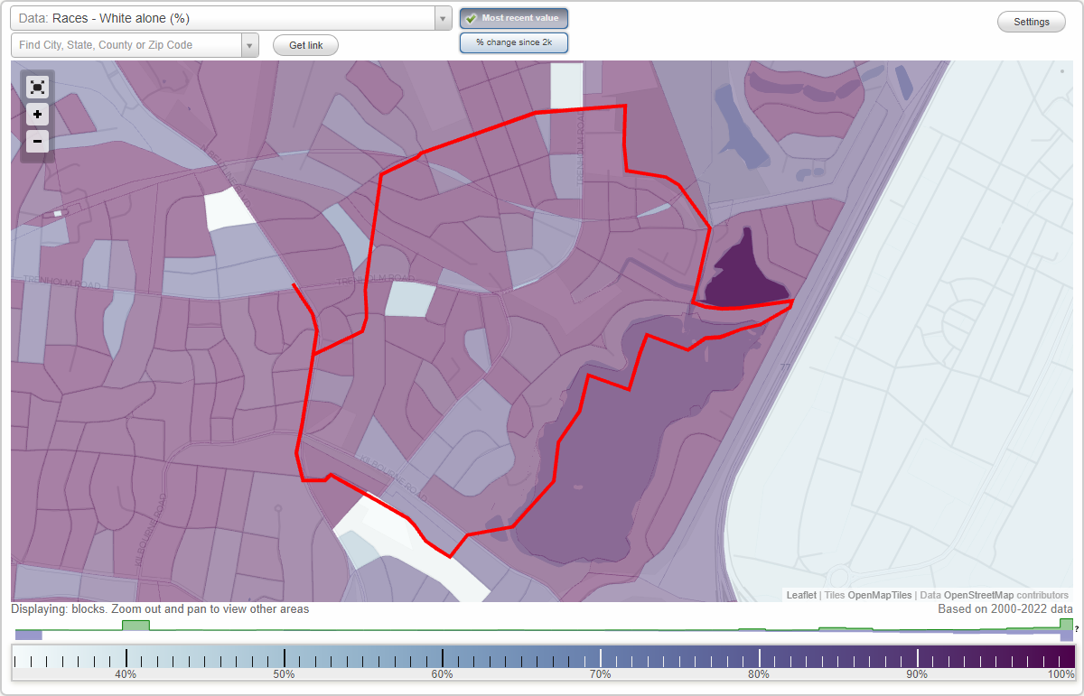
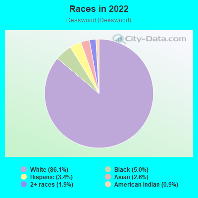
- 1,60286.1%White
- 935.0%Black
- 643.4%Hispanic or Latino
- 492.6%Asian
- 361.9%Two or more races
- 170.9%American Indian
Median household income in 2022:
| Deaswood (Deeswood): | $113,780 |
| Columbia: | $56,175 |
Distribution of median household income
![Distribution of median household income]()
- 25Less than $10,000
- 43$10,000 to $19,999
- 63$20,000 to $29,999
- 36$30,000 to $39,999
- 62$40,000 to $49,999
- 57$50,000 to $59,999
- 89$60,000 to $74,999
- 78$75,000 to $99,999
- 75$100,000 to $124,999
- 72$125,000 to $149,999
- 76$150,000 to $199,999
- 159$200,000 or more

Distribution of owner-occupied house/condo value
![Distribution of owner-occupied house/condo value]()
- 111$50,000 to $99,999
- 57$100,000 to $149,999
- 37$150,000 to $199,999
- 33$200,000 to $249,999
- 68$250,000 to $299,999
- 171$300,000 to $399,999
- 54$400,000 to $499,999
- 175$500,000 to $749,999
- 70$750,000 to $999,999
- 125$1,000,000 or more

Distribution of rent paid by renters
![Distribution of rent paid by renters]()
- 28$500 to $599
- 44$600 to $699
- 37$700 to $799
- 58$800 to $899
- 7$900 to $999
- 26$1,000 to $1,249
- 43$1,250 to $1,499
- 16$1,500 to $1,999
- 43$2,000 or more

| Males: | 916 |
| Females: | 889 |
Males:
| This neighborhood: | 42.6 years |
| Whole city: | 27.5 years |
| This neighborhood: | 42.1 years |
| Whole city: | 29.3 years |
Average household size:
| Deaswood (Deeswood): | 2.3 people |
| Columbia: | 2.1 people |
Percentage of family households:
| Deaswood (Deeswood): | 54.5% |
| Columbia: | 35.2% |
| Here: | 59.2% |
| Columbia: | 27.5% |
Percentage of married-couple families with children (among all households):
| Deaswood (Deeswood): | 35.1% |
| Columbia: | 23.7% |
Percentage of single-mother households (among all households):
| Deaswood (Deeswood): | 7.8% |
| Columbia: | 12.1% |
Percentage of never married males 15 years old and over:
Percentage of never married females 15 years old and over:
| Deaswood (Deeswood): | 14.6% |
| Columbia: | 31.8% |
Percentage of never married females 15 years old and over:
| Deaswood (Deeswood): | 5.9% |
| city: | 26.3% |
Percentage of people that speak English not well or not at all:
| Deaswood (Deeswood): | 0.3% |
| Columbia: | 0.6% |
Percentage of people born in this state:
Percentage of people born in another U.S. state:
Percentage of native residents but born outside the U.S.:
Percentage of foreign born residents:
| Here: | 62.4% |
| Columbia: | 53.1% |
Percentage of people born in another U.S. state:
| Deaswood (Deeswood): | 32.7% |
| Columbia: | 40.1% |
Percentage of native residents but born outside the U.S.:
| Here: | 1.5% |
| city: | 2.2% |
Percentage of foreign born residents:
| Here: | 3.4% |
| Columbia: | 4.6% |
Owner-occupied
Renter-occupied

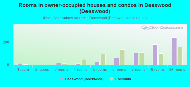
- Rooms in owner-occupied houses and condos in Deaswood <
> - 121 room
- 02 rooms
- 193 rooms
- 104 rooms
- 265 rooms
- 626 rooms
- 1047 rooms
- 1808 rooms
- 2409+ rooms
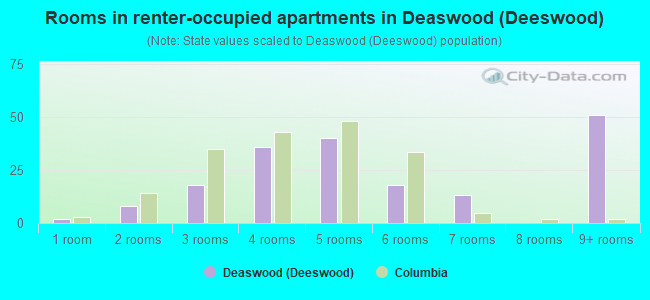
- Rooms in renter-occupied apartments in Deaswood <
> - 21 room
- 82 rooms
- 183 rooms
- 364 rooms
- 405 rooms
- 186 rooms
- 137 rooms
- 08 rooms
- 519+ rooms
Owner-occupied
Renter-occupied
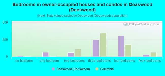
- Bedrooms in owner-occupied houses and condos in Deaswood <
> - 12no bedroom
- 631 bedroom
- 592 bedrooms
- 2463 bedrooms
- 3044 bedrooms
- 265+ bedrooms
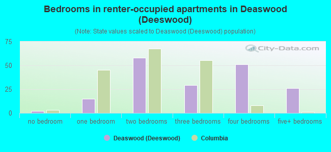
- Bedrooms in renter-occupied apartments in Deaswood <
> - 2no bedroom
- 151 bedroom
- 582 bedrooms
- 293 bedrooms
- 514 bedrooms
- 265+ bedrooms
Average number of cars or other vehicles available in houses/condos:
Average number of cars or other vehicles available in apartments:
| This neighborhood: | 2.0 |
| Columbia: | 1.8 |
Average number of cars or other vehicles available in apartments:
| Here: | 1.3 |
| city: | 1.3 |
Percentage of units with a mortgage:
| Deaswood (Deeswood): | 68.8% |
| Columbia: | 67.5% |
Average estimated value of detached houses in 2022 (83.0% of all units):
| Deaswood (Deeswood): | $543,161 |
| Columbia: | $305,357 |
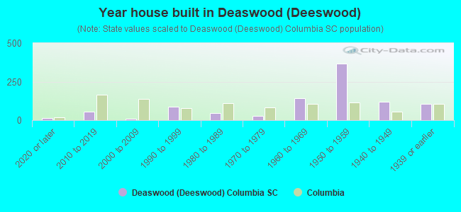
- Year house built in Deaswood <
> - 162020 or later
- 532010 to 2019
- 92000 to 2009
- 851990 to 1999
- 471980 to 1989
- 281970 to 1979
- 1421960 to 1969
- 3671950 to 1959
- 1171940 to 1949
- 1041939 or earlier
City-data.com crime index for city in 2020 (higher means more crime):
| City: | 446.0 |
| U.S. average: | 219.5 |
Travel time to work (commute)
![Travel time to work (commute)]()
- 16Less than 5 minutes
- 1045 to 9 minutes
- 18510 to 14 minutes
- 33015 to 19 minutes
- 10720 to 24 minutes
- 6025 to 29 minutes
- 2330 to 34 minutes
- 1935 to 39 minutes
- 1540 to 44 minutes
- 5745 to 59 minutes
- 160 to 89 minutes
- 590 or more minutes

Means of transportation to work
![Means of transportation to work]()
- 82.1%733Drove a car alone
- 6.5%58Carpooled
- 3.1%28Bus
- 1.6%14Subway or elevated rail
- 4.7%42Bicycle
- 3.4%30Walked
- 0.8%7Other means
- 10.9%97Worked at home

Time leaving home to go to work
![Time leaving home to go to work]()
- 512:00 a.m. to 4:59 a.m.
- 45:00 a.m. to 5:29 a.m.
- 315:30 a.m. to 5:59 a.m.
- 526:00 a.m. to 6:29 a.m.
- 976:30 a.m. to 6:59 a.m.
- 1117:00 a.m. to 7:29 a.m.
- 2117:30 a.m. to 7:59 a.m.
- 1568:00 a.m. to 8:29 a.m.
- 608:30 a.m. to 8:59 a.m.
- 939:00 a.m. to 9:59 a.m.
- 610:00 a.m. to 10:59 a.m.
- 1311:00 a.m. to 11:59 a.m.
- 4212:00 p.m. to 3:59 p.m.
- 184:00 p.m. to 11:59 p.m.

Occupations of males:
- Percentage of males in management occupations (except farmers):
Here: 14.3% city: 12.3%
- Percentage of males in business and financial operations occupations:
Here: 13.2% city: 4.6%
- Percentage of males in computer and mathematical occupations:
Here: 3.6% city: 3.7%
- Percentage of males in life, physical, and social science occupations:
Here: 2.2% city: 1.7%
- Percentage of males in legal occupations:
Here: 7.4% city: 2.9%
- Percentage of males in education, training, and library occupations:
Here: 3.8% city: 6.7%
- Percentage of males in arts, design, entertainment, sports, and media occupations:
Here: 1.4% city: 2.0%
- Percentage of males in healthcare practitioners and technical occupations:
Here: 21.9% city: 4.6%
- Percentage of males in service occupations:
Here: 4.7% city: 18.4%
- Percentage of males in sales and office occupations:
Here: 16.2% city: 16.6%
- Percentage of males in construction, extraction, and maintenance occupations:
Here: 2.6% city: 4.8%
- Percentage of males in transportation occupations:
Here: 6.3% city: 4.1%
- Percentage of males in material moving occupations:
Here: 2.4% city: 5.8%
Occupations of females:
- Percentage of females in management occupations (except farmers):
Here: 14.9% city: 8.8%
- Percentage of females in business and financial operations occupations:
Here: 7.0% city: 6.4%
- Percentage of females in computer and mathematical occupations:
Here: 2.5% city: 2.3%
- Percentage of females in life, physical, and social science occupations:
Here: 2.7% city: 1.4%
- Percentage of females in legal occupations:
Here: 8.7% city: 1.6%
- Percentage of females in education, training, and library occupations:
Here: 15.5% city: 11.5%
- Percentage of females in arts, design, entertainment, sports, and media occupations:
Here: 7.8% city: 2.6%
- Percentage of females in healthcare practitioners and technical occupations:
Here: 12.6% city: 8.7%
- Percentage of females in service occupations:
Here: 9.5% city: 20.2%
- Percentage of females in sales and office occupations:
Here: 18.4% city: 26.9%
Percentage of people 16-64 in Armed Forces:
| Deaswood (Deeswood): | 0.7% |
| Columbia: | 7.2% |
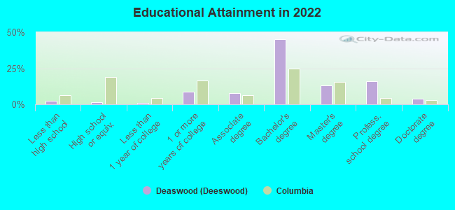
Education in this neighborhood (subdivision or community):
- Percentage of people 3 years and older in K-12 schools:
Deaswood (Deeswood): 22.8% Columbia: 12.2%
- Percentage of people 3 years and older in undergraduate colleges:
Deaswood (Deeswood): 2.3% Columbia: 16.2%
- Percentage of people 3 years and older in grad. or professional schools:
Deaswood (Deeswood): 3.9% Columbia: 3.5%
- Percentage of students K-12 enrolled in private schools:
Deaswood (Deeswood): 47.5% Columbia: 24.2%
Percentage of population below poverty level:
| Deaswood (Deeswood): | 5.0% |
| Columbia: | 20.7% |
Median year owner moved in (as recorded in 2022):
Median year renter moved in (as recorded in 2022):
| Deaswood (Deeswood): | 2009 |
| Columbia: | 2013 |
Median year renter moved in (as recorded in 2022):
| Deaswood (Deeswood): | 2012 |
| Columbia: | 2022 |
Percentage of married-couple families with both working:
| Deaswood (Deeswood): | 81.9% |
| Columbia: | 72.3% |
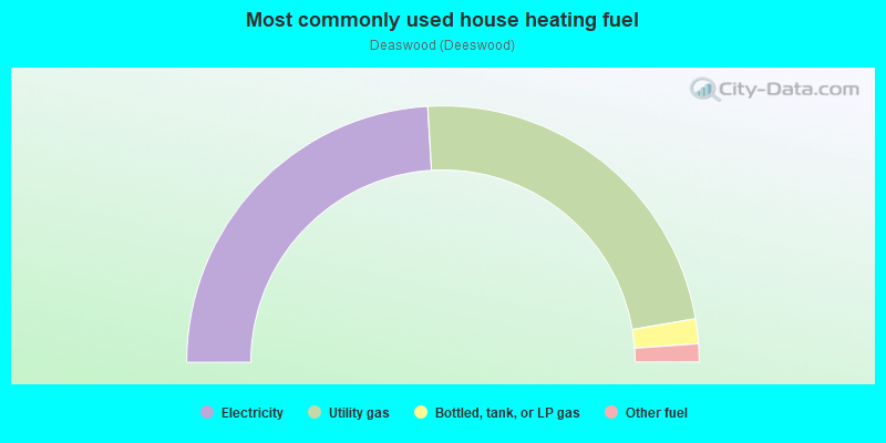
- 48.1%Electricity
- 46.5%Utility gas
- 3.1%Bottled, tank, or LP gas
- 2.3%Other fuel
Highways in this neighborhood:
State Hwy 16 (Beltline Blvd)
Length: 0.45 miles
Directions: N-S, SE-NW
Address range: 1100 to 1599
Directions: N-S, SE-NW
Address range: 1100 to 1599
State Hwy 16 (N Belt Line Blvd)
Length: 0.11 miles
Direction: SE-NW
Address range: 1600 to 1699
Direction: SE-NW
Address range: 1600 to 1699
Roads and streets:
Trenholm Rd
Length: 1.86 miles
Directions: E-W, N-S, SW-NE
Address range: 4100 to 4949
Directions: E-W, N-S, SW-NE
Address range: 4100 to 4949
Kathwood Dr
Length: 1.09 miles
Directions: E-W, N-S, SE-NW, SW-NE
Address range: 1300 to 1699
Directions: E-W, N-S, SE-NW, SW-NE
Address range: 1300 to 1699
Brennen Rd
Length: 0.81 miles
Directions: N-S, SE-NW, SW-NE
Address range: 1100 to 1699
Directions: N-S, SE-NW, SW-NE
Address range: 1100 to 1699
Kilbourne Rd
Length: 0.61 miles
Directions: E-W, SE-NW
Address range: 4200 to 4799
Directions: E-W, SE-NW
Address range: 4200 to 4799
Chicora St
Length: 0.49 miles
Direction: E-W
Address range: 4400 to 4799
Direction: E-W
Address range: 4400 to 4799
Pinemont Dr
Length: 0.47 miles
Directions: E-W, N-S, SE-NW, SW-NE
Address range: 1200 to 1599
Directions: E-W, N-S, SE-NW, SW-NE
Address range: 1200 to 1599
Woodlake Dr
Length: 0.41 miles
Directions: E-W, SE-NW
Address range: 1612 to 1750
Directions: E-W, SE-NW
Address range: 1612 to 1750
Forest Ridge Ln
Length: 0.38 miles
Directions: E-W, N-S, SE-NW
Address range: 4600 to 4899
Directions: E-W, N-S, SE-NW
Address range: 4600 to 4899
Carterhill Dr
Length: 0.38 miles
Directions: N-S, SW-NE
Address range: 4600 to 4999
Directions: N-S, SW-NE
Address range: 4600 to 4999
Sanford Rd
Length: 0.36 miles
Directions: E-W, SE-NW, SW-NE
Address range: 1200 to 1399
Directions: E-W, SE-NW, SW-NE
Address range: 1200 to 1399
Erskine St
Length: 0.33 miles
Directions: E-W, SE-NW
Address range: 4400 to 4699
Directions: E-W, SE-NW
Address range: 4400 to 4699
Quail Ln
Length: 0.33 miles
Directions: E-W, SW-NE
Address range: 4700 to 4931
Directions: E-W, SW-NE
Address range: 4700 to 4931
Graeme Dr
Length: 0.33 miles
Directions: E-W, N-S, SW-NE
Address range: 1600 to 1799
Directions: E-W, N-S, SW-NE
Address range: 1600 to 1799
Clemson Ave
Length: 0.32 miles
Directions: N-S, SE-NW
Address range: 4500 to 4899
Directions: N-S, SE-NW
Address range: 4500 to 4899
Portobello Rd
Length: 0.31 miles
Directions: E-W, SE-NW, SW-NE
Address range: 4700 to 4899
Directions: E-W, SE-NW, SW-NE
Address range: 4700 to 4899
Whitaker Dr
Length: 0.30 miles
Directions: N-S, SW-NE
Address range: 1200 to 1599
Directions: N-S, SW-NE
Address range: 1200 to 1599
Woodside Haven Dr
Length: 0.30 miles
Directions: E-W, SE-NW
Address range: 4300 to 4499
Directions: E-W, SE-NW
Address range: 4300 to 4499
Churchill Cir
Length: 0.28 miles
Directions: E-W, N-S, SE-NW, SW-NE
Address range: 1 to 199
Directions: E-W, N-S, SE-NW, SW-NE
Address range: 1 to 199
Ellison Rd
Length: 0.26 miles
Directions: N-S, SE-NW, SW-NE
Address range: 1300 to 1499
Directions: N-S, SE-NW, SW-NE
Address range: 1300 to 1499
Devereaux Rd
Length: 0.26 miles
Directions: E-W, SE-NW, SW-NE
Address range: 4200 to 4499
Directions: E-W, SE-NW, SW-NE
Address range: 4200 to 4499
Furman Ave (Lander St)
Length: 0.24 miles
Directions: N-S, SE-NW
Address range: 4600 to 4899
Directions: N-S, SE-NW
Address range: 4600 to 4899
St Clair Dr
Length: 0.24 miles
Directions: E-W, SE-NW, SW-NE
Address range: 4200 to 4299
Directions: E-W, SE-NW, SW-NE
Address range: 4200 to 4299
Sinkler Rd
Length: 0.23 miles
Directions: E-W, SW-NE
Address range: 1300 to 1399
Directions: E-W, SW-NE
Address range: 1300 to 1399
Bellefield Ln
Length: 0.23 miles
Directions: E-W, SE-NW
Address range: 4500 to 4699
Directions: E-W, SE-NW
Address range: 4500 to 4699
Limestone St
Length: 0.22 miles
Directions: E-W, SE-NW
Address range: 4500 to 4699
Directions: E-W, SE-NW
Address range: 4500 to 4699
Mac Gregor Dr
Length: 0.22 miles
Directions: E-W, SW-NE
Address range: 4100 to 4199
Directions: E-W, SW-NE
Address range: 4100 to 4199
Pineridge Rd
Length: 0.21 miles
Direction: SE-NW
Address range: 4300 to 4599
Direction: SE-NW
Address range: 4300 to 4599
Brockwall Dr
Length: 0.21 miles
Directions: E-W, N-S, SE-NW, SW-NE
Address range: 1500 to 1599
Directions: E-W, N-S, SE-NW, SW-NE
Address range: 1500 to 1599
Whittaker Dr
Length: 0.21 miles
Directions: N-S, SW-NE
Address range: 1200 to 1499
Directions: N-S, SW-NE
Address range: 1200 to 1499
Sequoia Rd
Length: 0.20 miles
Direction: E-W
Address range: 4200 to 4399
Direction: E-W
Address range: 4200 to 4399
Lonsford Dr
Length: 0.20 miles
Direction: N-S
Address range: 1500 to 1599
Direction: N-S
Address range: 1500 to 1599
Claremont Dr
Length: 0.20 miles
Directions: E-W, N-S, SW-NE
Address range: 4103 to 4299
Directions: E-W, N-S, SW-NE
Address range: 4103 to 4299
Roslyn Dr
Length: 0.17 miles
Directions: E-W, SE-NW
Address range: 1600 to 1699
Directions: E-W, SE-NW
Address range: 1600 to 1699
Lander St
Length: 0.16 miles
Directions: E-W, SW-NE
Address range: 4601 to 4799
Directions: E-W, SW-NE
Address range: 4601 to 4799
Perry Ct
Length: 0.16 miles
Directions: E-W, N-S, SE-NW, SW-NE
Address range: 4600 to 4699
Directions: E-W, N-S, SE-NW, SW-NE
Address range: 4600 to 4699
Wedgewood Dr
Length: 0.14 miles
Direction: SE-NW
Address range: 4400 to 4499
Direction: SE-NW
Address range: 4400 to 4499
Shadow Lawn Rd
Length: 0.13 miles
Direction: N-S
Address range: 4800 to 4999
Direction: N-S
Address range: 4800 to 4999
Calender Ct
Length: 0.13 miles
Direction: E-W
Address range: 1 to 99
Direction: E-W
Address range: 1 to 99
Lake Point Rd
Length: 0.13 miles
Directions: E-W, N-S, SE-NW
Address range: 5 to 99
Directions: E-W, N-S, SE-NW
Address range: 5 to 99
Linwood Rd
Length: 0.13 miles
Direction: E-W
Address range: 4100 to 4199
Direction: E-W
Address range: 4100 to 4199
Nandina Dr
Length: 0.13 miles
Direction: SE-NW
Address range: 4500 to 4599
Direction: SE-NW
Address range: 4500 to 4599
Pinegrove Ct
Length: 0.13 miles
Directions: E-W, SE-NW, SW-NE
Address range: 4600 to 4699
Directions: E-W, SE-NW, SW-NE
Address range: 4600 to 4699
Citadel Ave
Length: 0.12 miles
Directions: N-S, SE-NW
Address range: 4800 to 4899
Directions: N-S, SE-NW
Address range: 4800 to 4899
Landgrave Rd
Length: 0.12 miles
Direction: SE-NW
Address range: 4500 to 4599
Direction: SE-NW
Address range: 4500 to 4599
Lelias Ct
Length: 0.11 miles
Directions: E-W, SE-NW, SW-NE
Address range: 4600 to 4699
Directions: E-W, SE-NW, SW-NE
Address range: 4600 to 4699
Kenilworth Rd
Length: 0.11 miles
Directions: E-W, SE-NW
Address range: 4100 to 4199
Directions: E-W, SE-NW
Address range: 4100 to 4199
E Buchanan Dr
Length: 0.11 miles
Directions: N-S, SE-NW
Address range: 1601 to 1699
Directions: N-S, SE-NW
Address range: 1601 to 1699
Roundtop Rd
Length: 0.10 miles
Direction: E-W
Address range: 4100 to 4199
Direction: E-W
Address range: 4100 to 4199
S-40-1564 (Woodbine Ct)
Length: 0.10 miles
Directions: SE-NW, SW-NE
Address range: 1400 to 1599
Directions: SE-NW, SW-NE
Address range: 1400 to 1599
Hillside Rd
Length: 0.10 miles
Direction: SE-NW
Address range: 4900 to 4939
Direction: SE-NW
Address range: 4900 to 4939
Portobello Ct
Length: 0.09 miles
Direction: E-W
Address range: 4800 to 4899
Direction: E-W
Address range: 4800 to 4899
Mabar St
Length: 0.08 miles
Direction: SE-NW
Address range: 4500 to 4599
Direction: SE-NW
Address range: 4500 to 4599
Jonwall Ct
Length: 0.08 miles
Direction: SE-NW
Address range: 4500 to 4599
Direction: SE-NW
Address range: 4500 to 4599
Barker Cir
Length: 0.07 miles
Direction: SW-NE
Address range: 1400 to 1499
Direction: SW-NE
Address range: 1400 to 1499
Other features:
Penn Br
Length: 0.69 miles
Directions: E-W, SE-NW, SW-NE
Directions: E-W, SE-NW, SW-NE
Gills Crk
Length: 0.22 miles
Directions: N-S, SW-NE
Directions: N-S, SW-NE