Roseland (Rose Land) neighborhood in Mansfield, Ohio (OH), 44903, 44906 detailed profile
Settings
X


Business Search - 14 Million verified businesses
Area: 4.694 square miles
Population: 5,903
Population density:
| Roseland (Rose Land): | 1,258 people per square mile |
| Mansfield: | 1,593 people per square mile |

- 5,40279.9%White
- 5027.4%Two or more races
- 4907.2%Hispanic or Latino
- 1442.1%Black
- 1141.7%Asian
- 921.4%Some other race
- 160.2%American Indian
- 40.06%Native Hawaiian and Other
Pacific Islander

Distribution of median household income
![Distribution of median household income]()
- 119Less than $10,000
- 521$10,000 to $19,999
- 364$20,000 to $29,999
- 339$30,000 to $39,999
- 230$40,000 to $49,999
- 223$50,000 to $59,999
- 209$60,000 to $74,999
- 314$75,000 to $99,999
- 147$100,000 to $124,999
- 79$125,000 to $149,999
- 30$150,000 to $199,999
- 26$200,000 or more

Distribution of owner-occupied house/condo value
![Distribution of owner-occupied house/condo value]()
- 1,561Less than $50,000
- 1,040$50,000 to $99,999
- 81$100,000 to $149,999
- 153$150,000 to $199,999
- 143$200,000 to $249,999
- 62$250,000 to $299,999
- 60$300,000 to $399,999
- 23$400,000 to $499,999
- 40$500,000 to $749,999
- 10$750,000 to $999,999

Distribution of rent paid by renters
![Distribution of rent paid by renters]()
- 877Less than $100
- 95$100 to $199
- 192$200 to $299
- 130$300 to $399
- 208$400 to $499
- 283$500 to $599
- 240$600 to $699
- 104$700 to $799
- 110$800 to $899
- 18$900 to $999
- 59$1,000 to $1,249
- 58$1,250 to $1,499
- 39$1,500 to $1,999
- 2$2,000 or more

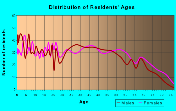
| Males: | 3,070 |
| Females: | 2,833 |
Males:
| This neighborhood: | 31.3 years |
| Whole city: | 37.4 years |
| This neighborhood: | 39.3 years |
| Whole city: | 42.1 years |
Average household size:
| Roseland (Rose Land): | 16.7 people |
| Mansfield: | 2.2 people |
Percentage of family households:
| Roseland (Rose Land): | 42.9% |
| Mansfield: | 34.5% |
| Here: | 37.6% |
| Mansfield: | 27.9% |
Percentage of married-couple families with children (among all households):
| Roseland (Rose Land): | 20.7% |
| Mansfield: | 17.4% |
Percentage of single-mother households (among all households):
| Roseland (Rose Land): | 15.7% |
| Mansfield: | 19.2% |
Percentage of never married males 15 years old and over:
Percentage of never married females 15 years old and over:
| Roseland (Rose Land): | 21.4% |
| Mansfield: | 26.3% |
Percentage of never married females 15 years old and over:
| Roseland (Rose Land): | 8.0% |
| city: | 15.9% |
Percentage of people that speak English not well or not at all:
| Roseland (Rose Land): | 0.3% |
| Mansfield: | 0.6% |
Percentage of people born in this state:
Percentage of people born in another U.S. state:
Percentage of native residents but born outside the U.S.:
Percentage of foreign born residents:
| Here: | 81.0% |
| Mansfield: | 77.5% |
Percentage of people born in another U.S. state:
| Roseland (Rose Land): | 17.0% |
| Mansfield: | 20.1% |
Percentage of native residents but born outside the U.S.:
| Here: | 0.7% |
| city: | 0.6% |
Percentage of foreign born residents:
| Here: | 1.5% |
| Mansfield: | 1.8% |

Owner-occupied
Renter-occupied


- Rooms in owner-occupied houses and condos in Roseland <
> - 01 room
- 92 rooms
- 1383 rooms
- 2304 rooms
- 6375 rooms
- 2346 rooms
- 2057 rooms
- 648 rooms
- 879+ rooms

- Rooms in renter-occupied apartments in Roseland <
> - 01 room
- 792 rooms
- 1293 rooms
- 2384 rooms
- 3835 rooms
- 3036 rooms
- 1047 rooms
- 738 rooms
- 279+ rooms
Owner-occupied
Renter-occupied

- Bedrooms in owner-occupied houses and condos in Roseland <
> - 0no bedroom
- 1151 bedroom
- 5822 bedrooms
- 8173 bedrooms
- 1324 bedrooms
- 415+ bedrooms

- Bedrooms in renter-occupied apartments in Roseland <
> - 0no bedroom
- 961 bedroom
- 4832 bedrooms
- 3483 bedrooms
- 1524 bedrooms
- 125+ bedrooms
Average number of cars or other vehicles available in houses/condos:
Average number of cars or other vehicles available in apartments:
| This neighborhood: | 1.9 |
| Mansfield: | 1.8 |
Average number of cars or other vehicles available in apartments:
| Here: | 1.7 |
| city: | 1.2 |
Percentage of units with a mortgage:
| Roseland (Rose Land): | 40.2% |
| Mansfield: | 53.5% |
Average estimated value of detached houses in 2022 (81.8% of all units):
| Roseland (Rose Land): | $97,692 |
| Mansfield: | $134,529 |

- Year house built in Roseland <
> - 172020 or later
- 532010 to 2019
- 2232000 to 2009
- 4201990 to 1999
- 1511980 to 1989
- 3181970 to 1979
- 3811960 to 1969
- 8071950 to 1959
- 3671940 to 1949
- 3721939 or earlier

City-data.com crime index for city in 2020 (higher means more crime):
| City: | 173.2 |
| U.S. average: | 219.5 |
Travel time to work (commute)
![Travel time to work (commute)]()
- 55Less than 5 minutes
- 3015 to 9 minutes
- 54010 to 14 minutes
- 22615 to 19 minutes
- 13920 to 24 minutes
- 4325 to 29 minutes
- 5130 to 34 minutes
- 4335 to 39 minutes
- 8340 to 44 minutes
- 8845 to 59 minutes
- 6260 to 89 minutes
- 15990 or more minutes

Means of transportation to work
![Means of transportation to work]()
- 80.8%1,865Drove a car alone
- 12.9%297Carpooled
- 2.0%46Bus
- 2.5%57Walked
- 3.0%69Other means
- 4.8%111Worked at home

Time leaving home to go to work
![Time leaving home to go to work]()
- 7712:00 a.m. to 4:59 a.m.
- 475:00 a.m. to 5:29 a.m.
- 1875:30 a.m. to 5:59 a.m.
- 456:00 a.m. to 6:29 a.m.
- 1196:30 a.m. to 6:59 a.m.
- 767:00 a.m. to 7:29 a.m.
- 1717:30 a.m. to 7:59 a.m.
- 1208:00 a.m. to 8:29 a.m.
- 928:30 a.m. to 8:59 a.m.
- 759:00 a.m. to 9:59 a.m.
- 9810:00 a.m. to 10:59 a.m.
- 3411:00 a.m. to 11:59 a.m.
- 19312:00 p.m. to 3:59 p.m.
- 1994:00 p.m. to 11:59 p.m.

Occupations of males:
- Percentage of males in management occupations (except farmers):
Here: 5.1% city: 7.7%
- Percentage of males in architecture and engineering occupations:
Here: 5.7% city: 2.0%
- Percentage of males in life, physical, and social science occupations:
Here: 1.3% city: 0.7%
- Percentage of males in legal occupations:
Here: 2.0% city: 0.5%
- Percentage of males in arts, design, entertainment, sports, and media occupations:
Here: 1.6% city: 0.4%
- Percentage of males in service occupations:
Here: 13.3% city: 18.3%
- Percentage of males in sales and office occupations:
Here: 10.1% city: 13.6%
- Percentage of males in construction, extraction, and maintenance occupations:
Here: 8.7% city: 4.2%
- Percentage of males in production occupations:
Here: 23.9% city: 14.0%
- Percentage of males in transportation occupations:
Here: 7.7% city: 8.0%
- Percentage of males in material moving occupations:
Here: 13.2% city: 10.4%
Occupations of females:
- Percentage of females in management occupations (except farmers):
Here: 2.6% city: 6.7%
- Percentage of females in legal occupations:
Here: 1.2% city: 0.5%
- Percentage of females in education, training, and library occupations:
Here: 3.4% city: 8.8%
- Percentage of females in healthcare practitioners and technical occupations:
Here: 5.4% city: 7.1%
- Percentage of females in service occupations:
Here: 36.3% city: 25.9%
- Percentage of females in sales and office occupations:
Here: 38.7% city: 27.3%
- Percentage of females in production occupations:
Here: 4.9% city: 9.2%
- Percentage of females in transportation occupations:
Here: 1.7% city: 1.3%
- Percentage of females in material moving occupations:
Here: 2.9% city: 4.0%
Percentage of people 16-64 in Armed Forces:
| Roseland (Rose Land): | 0.0% |
| Mansfield: | 0.0% |
Education in this neighborhood (subdivision or community):
- Percentage of people 3 years and older in K-12 schools:
Roseland (Rose Land): 18.9% Mansfield: 14.3%
- Percentage of people 3 years and older in undergraduate colleges:
Roseland (Rose Land): 2.2% Mansfield: 6.0%
- Percentage of people 3 years and older in grad. or professional schools:
Roseland (Rose Land): 2.3% Mansfield: 0.8%
- Percentage of students K-12 enrolled in private schools:
Roseland (Rose Land): 24.9% Mansfield: 14.1%
Percentage of population below poverty level:
| Roseland (Rose Land): | 20.8% |
| Mansfield: | 25.0% |
Median year owner moved in (as recorded in 2022):
Median year renter moved in (as recorded in 2022):
| Roseland (Rose Land): | 2000 |
| Mansfield: | 2006 |
Median year renter moved in (as recorded in 2022):
| Roseland (Rose Land): | 2017 |
| Mansfield: | 2016 |
Percentage of married-couple families with both working:
| Roseland (Rose Land): | 76.3% |
| Mansfield: | 69.3% |

- 79.1%Utility gas
- 9.7%Electricity
- 3.7%Wood
- 3.4%Bottled, tank, or LP gas
- 1.9%No fuel used
- 1.1%Fuel oil, kerosene, etc.
- 1.1%Other fuel
Highways in this neighborhood:
US Rte 30 E (US Rte 30)
Length: 7.39 miles
Directions: E-W, SE-NW
Address range: 199 to 245
Directions: E-W, SE-NW
Address range: 199 to 245
Springmill Rd (State Rte 39, State Rte 39 NW)
Length: 2.93 miles
Directions: E-W, SE-NW
Address range: 842 to 1553
Directions: E-W, SE-NW
Address range: 842 to 1553
Springmill St (State Rte 39 NW, State Rte 39)
Length: 0.50 miles
Directions: E-W, SE-NW
Address range: 805 to 839
Directions: E-W, SE-NW
Address range: 805 to 839
Roads and streets:
Poth Rd
Length: 2.52 miles
Directions: E-W, N-S, SE-NW, SW-NE
Address range: 449 to 1499
Directions: E-W, N-S, SE-NW, SW-NE
Address range: 449 to 1499
W Longview Ave
Length: 2.36 miles
Directions: E-W, SE-NW
Address range: 623 to 1601
Directions: E-W, SE-NW
Address range: 623 to 1601
Bowman St
Length: 2.17 miles
Directions: E-W, N-S, SE-NW, SW-NE
Address range: 707 to 1426
Directions: E-W, N-S, SE-NW, SW-NE
Address range: 707 to 1426
Hanna Rd
Length: 1.95 miles
Direction: E-W
Address range: 253 to 1099
Direction: E-W
Address range: 253 to 1099
N Trimble Rd
Length: 1.47 miles
Direction: N-S
Address range: 558 to 1314
Direction: N-S
Address range: 558 to 1314
Lenox Ave
Length: 1.32 miles
Direction: N-S
Address range: 623 to 1320
Direction: N-S
Address range: 623 to 1320
Walker Lake Rd
Length: 1.31 miles
Direction: E-W
Address range: 1039 to 1603
Direction: E-W
Address range: 1039 to 1603
Hahn Rd
Length: 1.24 miles
Direction: E-W
Address range: 535 to 1199
Direction: E-W
Address range: 535 to 1199
Fairfax Ave
Length: 1.18 miles
Direction: N-S
Address range: 612 to 1258
Direction: N-S
Address range: 612 to 1258
Belmont Ave
Length: 1.16 miles
Direction: N-S
Address range: 624 to 1260
Direction: N-S
Address range: 624 to 1260
N Home Rd
Length: 0.88 miles
Direction: N-S
Address range: 800 to 1236
Direction: N-S
Address range: 800 to 1236
Burger Ave
Length: 0.86 miles
Direction: N-S
Address range: 626 to 1258
Direction: N-S
Address range: 626 to 1258
Benedict Ave
Length: 0.82 miles
Directions: N-S, SW-NE
Address range: 626 to 1324
Directions: N-S, SW-NE
Address range: 626 to 1324
Warren Rd
Length: 0.80 miles
Direction: E-W
Address range: 293 to 621
Direction: E-W
Address range: 293 to 621
Caldwell St
Length: 0.80 miles
Direction: E-W
Address range: 949 to 1257
Direction: E-W
Address range: 949 to 1257
Dean Rd
Length: 0.75 miles
Direction: E-W
Address range: 327 to 616
Direction: E-W
Address range: 327 to 616
Averill Ave
Length: 0.65 miles
Direction: N-S
Address range: 627 to 1179
Direction: N-S
Address range: 627 to 1179
Harmon St
Length: 0.63 miles
Directions: E-W, SE-NW
Address range: 248 to 499
Directions: E-W, SE-NW
Address range: 248 to 499
Charles Ave
Length: 0.63 miles
Direction: E-W
Address range: 252 to 499
Direction: E-W
Address range: 252 to 499
Lantz Rd
Length: 0.61 miles
Direction: N-S
Address range: 221 to 500
Direction: N-S
Address range: 221 to 500
Leppo Rd
Length: 0.60 miles
Directions: N-S, SW-NE
Address range: 1500 to 1999
Directions: N-S, SW-NE
Address range: 1500 to 1999
Country Club Dr
Length: 0.57 miles
Directions: N-S, SW-NE
Address range: 862 to 1164
Directions: N-S, SW-NE
Address range: 862 to 1164
Walker St
Length: 0.57 miles
Direction: E-W
Address range: 1033 to 1259
Direction: E-W
Address range: 1033 to 1259
Wyandotte Ave
Length: 0.56 miles
Direction: E-W
Address range: 1040 to 1259
Direction: E-W
Address range: 1040 to 1259
Seminole Ave
Length: 0.56 miles
Direction: E-W
Address range: 1030 to 1260
Direction: E-W
Address range: 1030 to 1260
Herring Ave
Length: 0.54 miles
Direction: N-S
Address range: 879 to 1162
Direction: N-S
Address range: 879 to 1162
Pomerene Rd
Length: 0.53 miles
Direction: E-W
Address range: 227 to 499
Direction: E-W
Address range: 227 to 499
Pawnee Ave
Length: 0.53 miles
Direction: E-W
Address range: 1038 to 1259
Direction: E-W
Address range: 1038 to 1259
Concord Ave
Length: 0.51 miles
Direction: N-S
Address range: 476 to 899
Direction: N-S
Address range: 476 to 899
Harding Rd
Length: 0.49 miles
Direction: E-W
Address range: 256 to 423
Direction: E-W
Address range: 256 to 423
Louis St
Length: 0.45 miles
Direction: E-W
Address range: 253 to 534
Direction: E-W
Address range: 253 to 534
Truxell Dr
Length: 0.42 miles
Direction: N-S
Address range: 955 to 1209
Direction: N-S
Address range: 955 to 1209
Woodside Dr
Length: 0.40 miles
Directions: E-W, N-S, SW-NE
Address range: 987 to 1172
Directions: E-W, N-S, SW-NE
Address range: 987 to 1172
Crystal Springs Ave
Length: 0.38 miles
Direction: E-W
Address range: 242 to 399
Direction: E-W
Address range: 242 to 399
Old Bowman State Rd
Length: 0.33 miles
Direction: SE-NW
Address range: 1500 to 1599
Direction: SE-NW
Address range: 1500 to 1599
Empire Rd
Length: 0.33 miles
Directions: E-W, SW-NE
Address range: 335 to 499
Directions: E-W, SW-NE
Address range: 335 to 499
Armstrong St
Length: 0.31 miles
Direction: E-W
Address range: 644 to 765
Direction: E-W
Address range: 644 to 765
Steeple Chase Dr
Length: 0.27 miles
Directions: E-W, N-S, SE-NW
Address range: 1272 to 1385
Directions: E-W, N-S, SE-NW
Address range: 1272 to 1385
Winners Cir S (S Winners Circle Dr)
Length: 0.27 miles
Directions: E-W, N-S, SE-NW, SW-NE
Address range: 1200 to 1399
Directions: E-W, N-S, SE-NW, SW-NE
Address range: 1200 to 1399
N Winners Circle Dr (Winners Cir N)
Length: 0.27 miles
Directions: E-W, N-S, SE-NW, SW-NE
Address range: 1200 to 1377
Directions: E-W, N-S, SE-NW, SW-NE
Address range: 1200 to 1377
River Dr
Length: 0.26 miles
Direction: E-W
Address range: 1067 to 1167
Direction: E-W
Address range: 1067 to 1167
Pat Ln
Length: 0.26 miles
Direction: E-W
Address range: 1066 to 1165
Direction: E-W
Address range: 1066 to 1165
Wade Dr
Length: 0.26 miles
Direction: E-W
Address range: 1067 to 1168
Direction: E-W
Address range: 1067 to 1168
Nestor Dr
Length: 0.25 miles
Direction: E-W
Address range: 1064 to 1299
Direction: E-W
Address range: 1064 to 1299
Everett Ln
Length: 0.25 miles
Directions: E-W, N-S, SE-NW
Address range: 1168 to 1300
Directions: E-W, N-S, SE-NW
Address range: 1168 to 1300
Garfield Ave
Length: 0.25 miles
Direction: N-S
Address range: 965 to 1104
Direction: N-S
Address range: 965 to 1104
Dillon Rd
Length: 0.25 miles
Direction: N-S
Address range: 1129 to 1275
Direction: N-S
Address range: 1129 to 1275
Priar Rd
Length: 0.25 miles
Direction: N-S
Address range: 1018 to 1270
Direction: N-S
Address range: 1018 to 1270
Boyle Rd
Length: 0.25 miles
Direction: N-S
Address range: 1028 to 1363
Direction: N-S
Address range: 1028 to 1363
Fern Ave
Length: 0.24 miles
Directions: E-W, SE-NW
Address range: 258 to 340
Directions: E-W, SE-NW
Address range: 258 to 340
Grandview Ave
Length: 0.24 miles
Directions: E-W, SW-NE
Address range: 254 to 338
Directions: E-W, SW-NE
Address range: 254 to 338
Preakness Dr
Length: 0.23 miles
Direction: E-W
Address range: 1200 to 1399
Direction: E-W
Address range: 1200 to 1399
Stocking Ave
Length: 0.23 miles
Direction: N-S
Address range: 798 to 820
Direction: N-S
Address range: 798 to 820
Spring Village Ln
Length: 0.20 miles
Directions: E-W, N-S, SE-NW, SW-NE
Directions: E-W, N-S, SE-NW, SW-NE
Pond Rd
Length: 0.20 miles
Direction: N-S
Address range: 1115 to 1261
Direction: N-S
Address range: 1115 to 1261
Fir Dr
Length: 0.16 miles
Direction: E-W
Address range: 1000 to 1199
Direction: E-W
Address range: 1000 to 1199
Gary Dr
Length: 0.14 miles
Direction: N-S
Address range: 965 to 1040
Direction: N-S
Address range: 965 to 1040
Carl Rd
Length: 0.13 miles
Direction: N-S
Address range: 1088 to 1241
Direction: N-S
Address range: 1088 to 1241
Crandal Rd
Length: 0.13 miles
Direction: N-S
Address range: 1072 to 1276
Direction: N-S
Address range: 1072 to 1276
Stone Rd
Length: 0.13 miles
Direction: N-S
Address range: 518 to 1275
Direction: N-S
Address range: 518 to 1275
Paddock Dr
Length: 0.13 miles
Direction: N-S
Address range: 1300 to 1399
Direction: N-S
Address range: 1300 to 1399
Stelts Ln
Length: 0.13 miles
Directions: E-W, N-S, SW-NE
Address range: 600 to 699
Directions: E-W, N-S, SW-NE
Address range: 600 to 699
Delph Ave
Length: 0.12 miles
Directions: E-W, N-S, SE-NW, SW-NE
Address range: 801 to 884
Directions: E-W, N-S, SE-NW, SW-NE
Address range: 801 to 884
Mill Rd
Length: 0.12 miles
Direction: N-S
Address range: 1041 to 1104
Direction: N-S
Address range: 1041 to 1104
Walker Rd
Length: 0.08 miles
Direction: E-W
Address range: 907 to 942
Direction: E-W
Address range: 907 to 942
Harold Ave
Length: 0.08 miles
Direction: N-S
Address range: 575 to 618
Direction: N-S
Address range: 575 to 618
Dorothy Dr
Length: 0.08 miles
Directions: N-S, SE-NW, SW-NE
Address range: 776 to 811
Directions: N-S, SE-NW, SW-NE
Address range: 776 to 811
Stark St
Length: 0.07 miles
Direction: N-S
Address range: 640 to 676
Direction: N-S
Address range: 640 to 676
Fike Ave (Fike Dr)
Length: 0.06 miles
Direction: E-W
Address range: 625 to 672
Direction: E-W
Address range: 625 to 672
Park (Stocking Ave)
Length: 0.06 miles
Directions: N-S, SE-NW, SW-NE
Address range: 709 to 729
Directions: N-S, SE-NW, SW-NE
Address range: 709 to 729
Fairhaven
Length: 0.05 miles
Direction: N-S
Direction: N-S
Marcella Ave
Length: 0.05 miles
Direction: N-S
Address range: 700 to 799
Direction: N-S
Address range: 700 to 799
Fike Dr
Length: 0.04 miles
Direction: N-S
Address range: 600 to 668
Direction: N-S
Address range: 600 to 668
Springmill
Length: 0.03 miles
Direction: N-S
Address range: 801 to 999
Direction: N-S
Address range: 801 to 999
Railroad features:
Norfolk Southern Rlwy (Conrail RR)
Length: 3.82 miles
Directions: E-W, N-S, SE-NW, SW-NE
Directions: E-W, N-S, SE-NW, SW-NE
Baltimore and Ohio RR
Length: 2.44 miles
Directions: E-W, N-S, SE-NW
Directions: E-W, N-S, SE-NW
Other features:
Rocky Fork Mohican Riv
Length: 1.11 miles
Directions: E-W, N-S, SE-NW, SW-NE
Directions: E-W, N-S, SE-NW, SW-NE