Southside neighborhood in Columbus, Ohio (OH), 43207, 43206 detailed profile
Settings
X


Business Search - 14 Million verified businesses
Area: 4.585 square miles
Population: 22,798
Population density:
| Southside: | 4,973 people per square mile |
| Columbus: | 4,320 people per square mile |

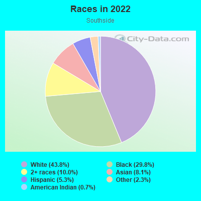
- 11,23243.8%White
- 7,63629.8%Black
- 2,57510.0%Two or more races
- 2,0698.1%Asian
- 1,3605.3%Hispanic or Latino
- 5842.3%Some other race
- 1700.7%American Indian

Distribution of median household income
![Distribution of median household income]()
- 692Less than $10,000
- 1,799$10,000 to $19,999
- 1,255$20,000 to $29,999
- 1,435$30,000 to $39,999
- 1,258$40,000 to $49,999
- 790$50,000 to $59,999
- 1,251$60,000 to $74,999
- 950$75,000 to $99,999
- 1,091$100,000 to $124,999
- 1,004$125,000 to $149,999
- 1,665$150,000 to $199,999
- 1,094$200,000 or more

Distribution of owner-occupied house/condo value
![Distribution of owner-occupied house/condo value]()
- 2,071Less than $50,000
- 2,435$50,000 to $99,999
- 1,120$100,000 to $149,999
- 1,361$150,000 to $199,999
- 1,344$200,000 to $249,999
- 822$250,000 to $299,999
- 1,619$300,000 to $399,999
- 1,767$400,000 to $499,999
- 324$500,000 to $749,999
- 289$750,000 to $999,999
- 385$1,000,000 or more

Distribution of rent paid by renters
![Distribution of rent paid by renters]()
- 987Less than $100
- 2,176$100 to $199
- 202$200 to $299
- 957$300 to $399
- 1,474$400 to $499
- 1,686$500 to $599
- 1,271$600 to $699
- 1,226$700 to $799
- 896$800 to $899
- 1,339$900 to $999
- 1,266$1,000 to $1,249
- 1,457$1,250 to $1,499
- 1,142$1,500 to $1,999
- 1,946$2,000 or more

| Males: | 11,567 |
| Females: | 11,231 |
Males:
| This neighborhood: | 36.4 years |
| Whole city: | 32.9 years |
| This neighborhood: | 38.5 years |
| Whole city: | 33.7 years |
Average household size:
| Southside: | 3.5 people |
| Columbus: | 2.3 people |
Percentage of family households:
| Southside: | 33.8% |
| Columbus: | 40.8% |
| Here: | 25.8% |
| Columbus: | 30.8% |
Percentage of married-couple families with children (among all households):
| Southside: | 26.5% |
| Columbus: | 23.7% |
Percentage of single-mother households (among all households):
| Southside: | 25.8% |
| Columbus: | 15.7% |
Percentage of never married males 15 years old and over:
Percentage of never married females 15 years old and over:
| Southside: | 26.5% |
| Columbus: | 24.6% |
Percentage of never married females 15 years old and over:
| Southside: | 23.7% |
| city: | 21.9% |
Percentage of people that speak English not well or not at all:
| Southside: | 1.1% |
| Columbus: | 3.5% |
Percentage of people born in this state:
Percentage of people born in another U.S. state:
Percentage of native residents but born outside the U.S.:
Percentage of foreign born residents:
| Here: | 67.6% |
| Columbus: | 61.6% |
Percentage of people born in another U.S. state:
| Southside: | 28.3% |
| Columbus: | 22.4% |
Percentage of native residents but born outside the U.S.:
| Here: | 0.7% |
| city: | 1.3% |
Percentage of foreign born residents:
| Here: | 3.8% |
| Columbus: | 14.7% |
Owner-occupied
Renter-occupied

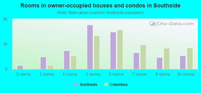
- Rooms in owner-occupied houses and condos in Southside
- 01 room
- 1422 rooms
- 4933 rooms
- 7374 rooms
- 1,7635 rooms
- 1,4846 rooms
- 6517 rooms
- 4738 rooms
- 5489+ rooms
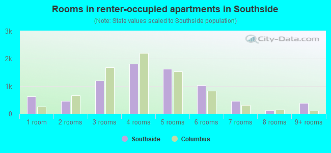
- Rooms in renter-occupied apartments in Southside
- 6211 room
- 4602 rooms
- 1,2043 rooms
- 1,8134 rooms
- 1,6305 rooms
- 1,0376 rooms
- 4717 rooms
- 1368 rooms
- 3889+ rooms
Owner-occupied
Renter-occupied
- Bedrooms in owner-occupied houses and condos in Southside
- 142no bedroom
- 2391 bedroom
- 2,3012 bedrooms
- 2,2723 bedrooms
- 5904 bedrooms
- 3125+ bedrooms
- Bedrooms in renter-occupied apartments in Southside
- 737no bedroom
- 1,3571 bedroom
- 2,8702 bedrooms
- 1,5833 bedrooms
- 3744 bedrooms
- 3105+ bedrooms
Average number of cars or other vehicles available in houses/condos:
Average number of cars or other vehicles available in apartments:
| This neighborhood: | 1.8 |
| Columbus: | 1.8 |
Average number of cars or other vehicles available in apartments:
| Here: | 1.3 |
| city: | 1.3 |
Percentage of units with a mortgage:
| Southside: | 65.2% |
| Columbus: | 69.3% |
Average estimated value of detached houses in 2022 (54.4% of all units):
| Southside: | $170,651 |
| Columbus: | $262,671 |
- Year house built in Southside
- 422020 or later
- 7972010 to 2019
- 6732000 to 2009
- 4241990 to 1999
- 2061980 to 1989
- 8421970 to 1979
- 2,0151960 to 1969
- 2,9191950 to 1959
- 1,2001940 to 1949
- 5,8811939 or earlier
City-data.com crime index for city in 2020 (higher means more crime):
| City: | 376.1 |
| U.S. average: | 219.5 |
Travel time to work (commute)
![Travel time to work (commute)]()
- 155Less than 5 minutes
- 8725 to 9 minutes
- 1,23810 to 14 minutes
- 1,52715 to 19 minutes
- 1,95320 to 24 minutes
- 64625 to 29 minutes
- 1,06930 to 34 minutes
- 34335 to 39 minutes
- 16540 to 44 minutes
- 64645 to 59 minutes
- 19260 to 89 minutes
- 9890 or more minutes

Means of transportation to work
![Means of transportation to work]()
- 74.6%8,841Drove a car alone
- 10.9%1,289Carpooled
- 4.1%485Bus
- 8.7%1,031Taxi
- 22.8%2,703Bicycle
- 4.0%477Walked
- 3.7%441Other means
- 12.7%1,503Worked at home

Time leaving home to go to work
![Time leaving home to go to work]()
- 38812:00 a.m. to 4:59 a.m.
- 2085:00 a.m. to 5:29 a.m.
- 3195:30 a.m. to 5:59 a.m.
- 4756:00 a.m. to 6:29 a.m.
- 1,0256:30 a.m. to 6:59 a.m.
- 8897:00 a.m. to 7:29 a.m.
- 9237:30 a.m. to 7:59 a.m.
- 9508:00 a.m. to 8:29 a.m.
- 6758:30 a.m. to 8:59 a.m.
- 8479:00 a.m. to 9:59 a.m.
- 24110:00 a.m. to 10:59 a.m.
- 10511:00 a.m. to 11:59 a.m.
- 88012:00 p.m. to 3:59 p.m.
- 7974:00 p.m. to 11:59 p.m.

Occupations of males:
- Percentage of males in management occupations (except farmers):
Here: 8.0% city: 10.2%
- Percentage of males in business and financial operations occupations:
Here: 7.0% city: 6.2%
- Percentage of males in computer and mathematical occupations:
Here: 3.5% city: 7.7%
- Percentage of males in architecture and engineering occupations:
Here: 1.3% city: 2.8%
- Percentage of males in community and social services occupations:
Here: 1.6% city: 1.2%
- Percentage of males in legal occupations:
Here: 1.3% city: 1.1%
- Percentage of males in education, training, and library occupations:
Here: 1.9% city: 3.8%
- Percentage of males in arts, design, entertainment, sports, and media occupations:
Here: 3.2% city: 2.1%
- Percentage of males in healthcare practitioners and technical occupations:
Here: 1.3% city: 2.9%
- Percentage of males in service occupations:
Here: 20.1% city: 13.8%
- Percentage of males in sales and office occupations:
Here: 16.4% city: 17.0%
- Percentage of males in farming, fishing, and forestry occupations:
Here: 1.8% city: 0.2%
- Percentage of males in construction, extraction, and maintenance occupations:
Here: 7.0% city: 5.2%
- Percentage of males in production occupations:
Here: 6.0% city: 6.5%
- Percentage of males in transportation occupations:
Here: 4.0% city: 6.4%
- Percentage of males in material moving occupations:
Here: 9.1% city: 7.9%
Occupations of females:
- Percentage of females in management occupations (except farmers):
Here: 5.2% city: 10.0%
- Percentage of females in business and financial operations occupations:
Here: 9.7% city: 8.2%
- Percentage of females in computer and mathematical occupations:
Here: 1.4% city: 2.6%
- Percentage of females in architecture and engineering occupations:
Here: 1.2% city: 0.6%
- Percentage of females in community and social services occupations:
Here: 1.7% city: 3.0%
- Percentage of females in legal occupations:
Here: 2.0% city: 1.3%
- Percentage of females in education, training, and library occupations:
Here: 5.5% city: 7.9%
- Percentage of females in arts, design, entertainment, sports, and media occupations:
Here: 3.5% city: 2.1%
- Percentage of females in healthcare practitioners and technical occupations:
Here: 10.9% city: 10.2%
- Percentage of females in service occupations:
Here: 21.4% city: 19.3%
- Percentage of females in sales and office occupations:
Here: 24.0% city: 25.0%
- Percentage of females in production occupations:
Here: 7.6% city: 3.0%
- Percentage of females in transportation occupations:
Here: 1.3% city: 1.3%
- Percentage of females in material moving occupations:
Here: 3.4% city: 3.7%
Percentage of people 16-64 in Armed Forces:
| Southside: | 0.0% |
| Columbus: | 0.2% |
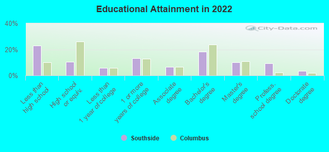
Education in this neighborhood (subdivision or community):
- Percentage of people 3 years and older in K-12 schools:
Southside: 22.9% Columbus: 15.2%
- Percentage of people 3 years and older in undergraduate colleges:
Southside: 5.1% Columbus: 6.7%
- Percentage of people 3 years and older in grad. or professional schools:
Southside: 12.9% Columbus: 2.4%
- Percentage of students K-12 enrolled in private schools:
Southside: 85.0% Columbus: 13.8%
Percentage of population below poverty level:
| Southside: | 21.7% |
| Columbus: | 18.1% |
Percentage of married-couple families with both working:
| Southside: | 156.5% |
| Columbus: | 75.5% |
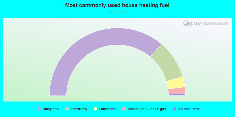
- 72.4%Utility gas
- 18.6%Electricity
- 5.0%Other fuel
- 3.2%Bottled, tank, or LP gas
- 0.9%No fuel used
Highways in this neighborhood:
Frank Rd (Frank-Refugee Expy, State Rte 104)
Length: 1.98 miles
Direction: E-W
Address range: 9712 to 10095
Direction: E-W
Address range: 9712 to 10095
S High St (US Hwy 23)
Length: 1.27 miles
Direction: N-S
Address range: 1100 to 1956
Direction: N-S
Address range: 1100 to 1956
State Rte 104 (James L Wagner Memorial Hwy)
Length: 1.21 miles
Direction: E-W
Direction: E-W
Roads and streets:
Refugee Rd
Length: 2.35 miles
Directions: E-W, SW-NE
Address range: 1119 to 2601
Directions: E-W, SW-NE
Address range: 1119 to 2601
E Woodrow Ave
Length: 2.19 miles
Direction: E-W
Address range: 1 to 1223
Direction: E-W
Address range: 1 to 1223
E Markison Ave
Length: 2.14 miles
Direction: E-W
Address range: 1 to 1250
Direction: E-W
Address range: 1 to 1250
E Jenkins Ave
Length: 1.99 miles
Direction: E-W
Address range: 1 to 1081
Direction: E-W
Address range: 1 to 1081
Marion Rd
Length: 1.98 miles
Directions: E-W, N-S
Address range: 400 to 1500
Directions: E-W, N-S
Address range: 400 to 1500
Smith Rd
Length: 1.55 miles
Directions: E-W, SE-NW, SW-NE
Address range: 828 to 1710
Directions: E-W, SE-NW, SW-NE
Address range: 828 to 1710
E Innis Ave
Length: 1.53 miles
Direction: E-W
Address range: 1 to 1381
Direction: E-W
Address range: 1 to 1381
E Moler St
Length: 1.36 miles
Direction: E-W
Address range: 1 to 799
Direction: E-W
Address range: 1 to 799
Southwood Ave
Length: 1.34 miles
Direction: E-W
Address range: 1 to 774
Direction: E-W
Address range: 1 to 774
Parsons Ave
Length: 1.33 miles
Direction: N-S
Address range: 1242 to 2209
Direction: N-S
Address range: 1242 to 2209
Moler Rd
Length: 1.28 miles
Direction: E-W
Address range: 1099 to 2100
Direction: E-W
Address range: 1099 to 2100
Reeb Ave
Length: 1.28 miles
Direction: E-W
Address range: 1 to 1120
Direction: E-W
Address range: 1 to 1120
S 4th St
Length: 1.18 miles
Direction: N-S
Address range: 1150 to 1999
Direction: N-S
Address range: 1150 to 1999
E Morrill Ave
Length: 1.16 miles
Direction: E-W
Address range: 1 to 699
Direction: E-W
Address range: 1 to 699
Bruck St
Length: 1.15 miles
Direction: N-S
Address range: 1185 to 2099
Direction: N-S
Address range: 1185 to 2099
Sheldon Ave
Length: 1.14 miles
Direction: E-W
Address range: 250 to 1182
Direction: E-W
Address range: 250 to 1182
Fairwood Ave
Length: 1.09 miles
Direction: N-S
Address range: 1701 to 2423
Direction: N-S
Address range: 1701 to 2423
E Welch Ave
Length: 1.09 miles
Direction: E-W
Address range: 1 to 710
Direction: E-W
Address range: 1 to 710
S 6th St
Length: 0.96 miles
Direction: N-S
Address range: 1356 to 1968
Direction: N-S
Address range: 1356 to 1968
Lockbourne Rd
Length: 0.95 miles
Direction: N-S
Address range: 1593 to 2265
Direction: N-S
Address range: 1593 to 2265
S Washington Ave
Length: 0.92 miles
Direction: N-S
Address range: 1207 to 2028
Direction: N-S
Address range: 1207 to 2028
E Gates St
Length: 0.87 miles
Direction: E-W
Address range: 1 to 451
Direction: E-W
Address range: 1 to 451
8th St
Length: 0.87 miles
Directions: N-S, SW-NE
Address range: 1301 to 1988
Directions: N-S, SW-NE
Address range: 1301 to 1988
Hanford St
Length: 0.86 miles
Direction: E-W
Address range: 1 to 451
Direction: E-W
Address range: 1 to 451
Hosack St
Length: 0.85 miles
Direction: E-W
Address range: 1 to 599
Direction: E-W
Address range: 1 to 599
Lawrence Dr
Length: 0.82 miles
Direction: E-W
Address range: 851 to 1214
Direction: E-W
Address range: 851 to 1214
E Hinman Ave
Length: 0.80 miles
Direction: E-W
Address range: 91 to 530
Direction: E-W
Address range: 91 to 530
E Mithoff St
Length: 0.77 miles
Direction: E-W
Address range: 1 to 399
Direction: E-W
Address range: 1 to 399
Stambaugh Ave
Length: 0.76 miles
Directions: E-W, N-S, SE-NW, SW-NE
Address range: 349 to 837
Directions: E-W, N-S, SE-NW, SW-NE
Address range: 349 to 837
Frebis Ave
Length: 0.76 miles
Direction: E-W
Address range: 38 to 459
Direction: E-W
Address range: 38 to 459
E Barthman Ave
Length: 0.76 miles
Direction: E-W
Address range: 1 to 406
Direction: E-W
Address range: 1 to 406
Alum Creek Dr
Length: 0.75 miles
Directions: N-S, SE-NW
Address range: 1980 to 2416
Directions: N-S, SE-NW
Address range: 1980 to 2416
Nursery Ln
Length: 0.72 miles
Direction: E-W
Address range: 88 to 399
Direction: E-W
Address range: 88 to 399
Elwood Ave
Length: 0.68 miles
Direction: E-W
Address range: 399 to 820
Direction: E-W
Address range: 399 to 820
S 3rd St
Length: 0.65 miles
Direction: N-S
Address range: 1325 to 1922
Direction: N-S
Address range: 1325 to 1922
Goethe St
Length: 0.65 miles
Direction: N-S
Address range: 1581 to 2030
Direction: N-S
Address range: 1581 to 2030
S Champion Ave
Length: 0.64 miles
Direction: N-S
Address range: 1577 to 2050
Direction: N-S
Address range: 1577 to 2050
Hinkle Ave
Length: 0.61 miles
Direction: E-W
Address range: 116 to 274
Direction: E-W
Address range: 116 to 274
Wilson Ave
Length: 0.55 miles
Direction: N-S
Address range: 1570 to 1976
Direction: N-S
Address range: 1570 to 1976
Oakwood Ave
Length: 0.54 miles
Direction: N-S
Address range: 1595 to 1964
Direction: N-S
Address range: 1595 to 1964
Marion Dr N
Length: 0.54 miles
Directions: E-W, N-S, SW-NE
Address range: 1249 to 1500
Directions: E-W, N-S, SW-NE
Address range: 1249 to 1500
Universal Rd
Length: 0.53 miles
Direction: E-W
Address range: 1400 to 1699
Direction: E-W
Address range: 1400 to 1699
Winslow Dr
Length: 0.51 miles
Directions: E-W, SW-NE
Address range: 1967 to 2215
Directions: E-W, SW-NE
Address range: 1967 to 2215
S 5th St
Length: 0.51 miles
Direction: N-S
Address range: 1345 to 1956
Direction: N-S
Address range: 1345 to 1956
Ann St
Length: 0.51 miles
Directions: N-S, SW-NE
Address range: 1427 to 1808
Directions: N-S, SW-NE
Address range: 1427 to 1808
S 18th St
Length: 0.49 miles
Direction: N-S
Address range: 1443 to 1773
Direction: N-S
Address range: 1443 to 1773
S Pearl St
Length: 0.49 miles
Direction: N-S
Address range: 1143 to 1714
Direction: N-S
Address range: 1143 to 1714
Buckeye Park Rd
Length: 0.48 miles
Direction: E-W
Address range: 880 to 1021
Direction: E-W
Address range: 880 to 1021
Linwood Ave
Length: 0.46 miles
Direction: N-S
Address range: 1582 to 2059
Direction: N-S
Address range: 1582 to 2059
Progress Ave
Length: 0.45 miles
Directions: N-S, SW-NE
Address range: 1770 to 2011
Directions: N-S, SW-NE
Address range: 1770 to 2011
Merritt St
Length: 0.45 miles
Direction: E-W
Address range: 1 to 399
Direction: E-W
Address range: 1 to 399
Kelton Ave
Length: 0.43 miles
Directions: N-S, SW-NE
Address range: 1700 to 1999
Directions: N-S, SW-NE
Address range: 1700 to 1999
City Park Ave
Length: 0.39 miles
Direction: N-S
Address range: 1129 to 1406
Direction: N-S
Address range: 1129 to 1406
Berkeley Rd
Length: 0.39 miles
Directions: E-W, N-S, SW-NE
Address range: 1301 to 1955
Directions: E-W, N-S, SW-NE
Address range: 1301 to 1955
S Front St
Length: 0.35 miles
Directions: N-S, SE-NW
Address range: 1105 to 1406
Directions: N-S, SE-NW
Address range: 1105 to 1406
Refugee Ln
Length: 0.35 miles
Direction: E-W
Direction: E-W
Holburn Ave
Length: 0.31 miles
Directions: N-S, SW-NE
Address range: 1736 to 1951
Directions: N-S, SW-NE
Address range: 1736 to 1951
Studer Ave
Length: 0.29 miles
Direction: N-S
Address range: 1895 to 2051
Direction: N-S
Address range: 1895 to 2051
S 19th St
Length: 0.29 miles
Direction: N-S
Address range: 1442 to 2230
Direction: N-S
Address range: 1442 to 2230
Refugee Park
Length: 0.28 miles
Direction: N-S
Address range: 2344 to 2421
Direction: N-S
Address range: 2344 to 2421
Liscomb Rd
Length: 0.28 miles
Direction: E-W
Address range: 1500 to 1799
Direction: E-W
Address range: 1500 to 1799
S Wall St
Length: 0.28 miles
Direction: N-S
Address range: 1400 to 1899
Direction: N-S
Address range: 1400 to 1899
Groveport Rd
Length: 0.28 miles
Direction: SE-NW
Address range: 2099 to 2280
Direction: SE-NW
Address range: 2099 to 2280
Bucher St
Length: 0.28 miles
Direction: N-S
Address range: 1715 to 2024
Direction: N-S
Address range: 1715 to 2024
Federal Pkwy
Length: 0.27 miles
Direction: N-S
Address range: 1800 to 1999
Direction: N-S
Address range: 1800 to 1999
Nason Ave
Length: 0.26 miles
Directions: N-S, SE-NW
Address range: 1719 to 1899
Directions: N-S, SE-NW
Address range: 1719 to 1899
Camaro Dr (Camaro Ave)
Length: 0.26 miles
Directions: E-W, SE-NW
Address range: 1929 to 2070
Directions: E-W, SE-NW
Address range: 1929 to 2070
S 20th St
Length: 0.25 miles
Direction: N-S
Address range: 1549 to 1801
Direction: N-S
Address range: 1549 to 1801
Corvair Ave
Length: 0.25 miles
Direction: E-W
Address range: 1929 to 2070
Direction: E-W
Address range: 1929 to 2070
Kermit Ave
Length: 0.25 miles
Directions: N-S, SW-NE
Address range: 1739 to 1910
Directions: N-S, SW-NE
Address range: 1739 to 1910
S 17th St
Length: 0.24 miles
Direction: N-S
Address range: 1434 to 1600
Direction: N-S
Address range: 1434 to 1600
Stanford Pl
Length: 0.24 miles
Directions: E-W, N-S, SE-NW, SW-NE
Address range: 282 to 328
Directions: E-W, N-S, SE-NW, SW-NE
Address range: 282 to 328
Advance Ave
Length: 0.24 miles
Direction: N-S
Address range: 1999 to 2299
Direction: N-S
Address range: 1999 to 2299
Greenlawn Ave
Length: 0.24 miles
Direction: E-W
Address range: 1 to 47
Direction: E-W
Address range: 1 to 47
Weiler Ave
Length: 0.24 miles
Directions: N-S, SE-NW
Address range: 1200 to 1859
Directions: N-S, SE-NW
Address range: 1200 to 1859
Wall St
Length: 0.23 miles
Direction: N-S
Direction: N-S
E Neff Ave
Length: 0.22 miles
Direction: E-W
Address range: 86 to 99
Direction: E-W
Address range: 86 to 99
Roberts Pl
Length: 0.22 miles
Direction: E-W
Address range: 1250 to 1382
Direction: E-W
Address range: 1250 to 1382
Jaeger St
Length: 0.22 miles
Direction: N-S
Address range: 1163 to 1306
Direction: N-S
Address range: 1163 to 1306
Olpp Ave
Length: 0.21 miles
Directions: E-W, SW-NE
Address range: 418 to 520
Directions: E-W, SW-NE
Address range: 418 to 520
Pannell Ave
Length: 0.21 miles
Direction: N-S
Address range: 1800 to 1947
Direction: N-S
Address range: 1800 to 1947
Valcon Ave
Length: 0.20 miles
Directions: N-S, SW-NE
Address range: 1785 to 1930
Directions: N-S, SW-NE
Address range: 1785 to 1930
Goethe Ave
Length: 0.20 miles
Direction: N-S
Direction: N-S
Lockhurst Rd
Length: 0.19 miles
Directions: E-W, SE-NW
Address range: 1165 to 1260
Directions: E-W, SE-NW
Address range: 1165 to 1260
Wager St
Length: 0.17 miles
Direction: N-S
Address range: 1417 to 1536
Direction: N-S
Address range: 1417 to 1536
English Rd
Length: 0.16 miles
Direction: N-S
Address range: 2390 to 2601
Direction: N-S
Address range: 2390 to 2601
W Moler St
Length: 0.16 miles
Direction: E-W
Address range: 1 to 105
Direction: E-W
Address range: 1 to 105
Molly Ln
Length: 0.16 miles
Direction: E-W
Address range: 1314 to 1386
Direction: E-W
Address range: 1314 to 1386
S 9th St
Length: 0.15 miles
Directions: N-S, SE-NW
Address range: 1900 to 2099
Directions: N-S, SE-NW
Address range: 1900 to 2099
Eldorn Dr
Length: 0.15 miles
Direction: E-W
Address range: 1317 to 1872
Direction: E-W
Address range: 1317 to 1872
Wagner St
Length: 0.14 miles
Direction: N-S
Direction: N-S
W Neff Ave
Length: 0.14 miles
Direction: E-W
Address range: 1 to 110
Direction: E-W
Address range: 1 to 110
Ronald Dr
Length: 0.13 miles
Direction: N-S
Address range: 1915 to 1999
Direction: N-S
Address range: 1915 to 1999
W Jenkins Ave
Length: 0.13 miles
Direction: E-W
Address range: 1 to 99
Direction: E-W
Address range: 1 to 99
Lamson Ave
Length: 0.13 miles
Directions: E-W, SE-NW
Address range: 1289 to 1363
Directions: E-W, SE-NW
Address range: 1289 to 1363
Page Rd
Length: 0.13 miles
Direction: E-W
Address range: 1634 to 1706
Direction: E-W
Address range: 1634 to 1706
Louis Dr
Length: 0.13 miles
Directions: E-W, N-S, SE-NW
Address range: 1243 to 1316
Directions: E-W, N-S, SE-NW
Address range: 1243 to 1316
Corvair Blvd
Length: 0.13 miles
Directions: E-W, SW-NE
Address range: 2000 to 2199
Directions: E-W, SW-NE
Address range: 2000 to 2199
Kian Ave
Length: 0.12 miles
Direction: E-W
Address range: 400 to 499
Direction: E-W
Address range: 400 to 499
Eldorn Dr E
Length: 0.12 miles
Directions: E-W, N-S, SW-NE
Address range: 1789 to 1879
Directions: E-W, N-S, SW-NE
Address range: 1789 to 1879
W Gates St
Length: 0.12 miles
Direction: E-W
Address range: 1 to 82
Direction: E-W
Address range: 1 to 82
Toronado Blvd (Toronado St)
Length: 0.12 miles
Directions: N-S, SE-NW, SW-NE
Address range: 1929 to 2030
Directions: N-S, SE-NW, SW-NE
Address range: 1929 to 2030
Galaxie St
Length: 0.11 miles
Directions: N-S, SE-NW, SW-NE
Address range: 1929 to 2000
Directions: N-S, SE-NW, SW-NE
Address range: 1929 to 2000
Mithoff St
Length: 0.11 miles
Direction: E-W
Address range: 399 to 460
Direction: E-W
Address range: 399 to 460
W Markison Ave
Length: 0.11 miles
Direction: E-W
Address range: 1 to 54
Direction: E-W
Address range: 1 to 54
S 8th St
Length: 0.10 miles
Direction: N-S
Address range: 1900 to 1966
Direction: N-S
Address range: 1900 to 1966
Curtis St
Length: 0.10 miles
Direction: N-S
Address range: 2149 to 2250
Direction: N-S
Address range: 2149 to 2250
Bucher
Length: 0.10 miles
Direction: N-S
Address range: 1700 to 1751
Direction: N-S
Address range: 1700 to 1751
Haviland Dr
Length: 0.09 miles
Direction: SE-NW
Address range: 2130 to 2198
Direction: SE-NW
Address range: 2130 to 2198
Arness Ave
Length: 0.09 miles
Direction: E-W
Address range: 1034 to 1098
Direction: E-W
Address range: 1034 to 1098
Durwin Ave
Length: 0.09 miles
Direction: E-W
Address range: 1030 to 1099
Direction: E-W
Address range: 1030 to 1099
Acorn Ave
Length: 0.09 miles
Direction: E-W
Address range: 1035 to 1077
Direction: E-W
Address range: 1035 to 1077
Ellsworth Ave
Length: 0.08 miles
Direction: N-S
Address range: 1837 to 1938
Direction: N-S
Address range: 1837 to 1938
W Hinman Ave
Length: 0.08 miles
Direction: E-W
Address range: 1 to 40
Direction: E-W
Address range: 1 to 40
W Welch Ave
Length: 0.08 miles
Direction: E-W
Address range: 1 to 52
Direction: E-W
Address range: 1 to 52
Mareco Pl E
Length: 0.08 miles
Directions: N-S, SE-NW
Address range: 1331 to 1856
Directions: N-S, SE-NW
Address range: 1331 to 1856
Mareco Pl
Length: 0.08 miles
Directions: E-W, SE-NW
Address range: 1331 to 1364
Directions: E-W, SE-NW
Address range: 1331 to 1364
Westrun St
Length: 0.08 miles
Direction: N-S
Address range: 1743 to 1799
Direction: N-S
Address range: 1743 to 1799
Eastern St
Length: 0.08 miles
Direction: N-S
Address range: 1744 to 1799
Direction: N-S
Address range: 1744 to 1799
Waycross St
Length: 0.08 miles
Direction: N-S
Address range: 1800 to 1855
Direction: N-S
Address range: 1800 to 1855
Estes St
Length: 0.08 miles
Direction: N-S
Address range: 1800 to 1852
Direction: N-S
Address range: 1800 to 1852
Valcon Pl
Length: 0.07 miles
Directions: E-W, SE-NW
Address range: 1578 to 1630
Directions: E-W, SE-NW
Address range: 1578 to 1630
Tanoc St
Length: 0.06 miles
Direction: N-S
Address range: 1977 to 1998
Direction: N-S
Address range: 1977 to 1998
Burton Ave
Length: 0.06 miles
Direction: E-W
Address range: 1041 to 1080
Direction: E-W
Address range: 1041 to 1080
Crown Ave
Length: 0.06 miles
Direction: E-W
Address range: 1035 to 1086
Direction: E-W
Address range: 1035 to 1086
Bass Ave
Length: 0.06 miles
Direction: E-W
Address range: 1041 to 1077
Direction: E-W
Address range: 1041 to 1077
Carliss Ave
Length: 0.06 miles
Direction: E-W
Address range: 1033 to 1081
Direction: E-W
Address range: 1033 to 1081
Dans Ave
Length: 0.06 miles
Direction: E-W
Address range: 1039 to 1099
Direction: E-W
Address range: 1039 to 1099
W Barthman Ave
Length: 0.06 miles
Direction: E-W
Address range: 1 to 199
Direction: E-W
Address range: 1 to 199
Smith Ct
Length: 0.05 miles
Direction: N-S
Address range: 1800 to 1830
Direction: N-S
Address range: 1800 to 1830
Southwind Villa
Length: 0.05 miles
Direction: N-S
Direction: N-S
Cochrane Ave
Length: 0.05 miles
Direction: E-W
Address range: 413 to 417
Direction: E-W
Address range: 413 to 417
W Morrill Ave
Length: 0.05 miles
Direction: E-W
Address range: 1 to 56
Direction: E-W
Address range: 1 to 56
W Innis Ave
Length: 0.05 miles
Direction: E-W
Address range: 1 to 68
Direction: E-W
Address range: 1 to 68
Marion Sq Rd
Length: 0.04 miles
Direction: N-S
Direction: N-S
Eagle Ave
Length: 0.04 miles
Directions: N-S, SE-NW
Address range: 2215 to 2232
Directions: N-S, SE-NW
Address range: 2215 to 2232
Railroad features:
Norfolk and Western Rlwy
Length: 2.38 miles
Directions: N-S, SW-NE
Directions: N-S, SW-NE
Chesapeake and Ohio Rlwy
Length: 2.05 miles
Directions: N-S, SE-NW
Directions: N-S, SE-NW
Municipal RR
Length: 0.02 miles
Direction: SW-NE
Direction: SW-NE