University neighborhood in Akron, Ohio (OH), 44304, 44306, 44311 detailed profile
Settings
X


Business Search - 14 Million verified businesses
Area: 1.333 square miles
Population: 6,412
Population density:
| University: | 4,810 people per square mile |
| Akron: | 3,037 people per square mile |

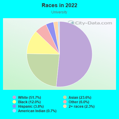
- 4,45765.0%White
- 1,14116.6%Black
- 4546.6%Asian
- 3625.3%Some other race
- 2463.6%Two or more races
- 1582.3%Hispanic or Latino
- 400.6%American Indian

Median household income in 2022:
| University: | $31,752 |
| Akron: | $45,534 |
Distribution of median household income
![Distribution of median household income]()
- 350Less than $10,000
- 425$10,000 to $19,999
- 517$20,000 to $29,999
- 356$30,000 to $39,999
- 635$40,000 to $49,999
- 179$50,000 to $59,999
- 306$60,000 to $74,999
- 177$75,000 to $99,999
- 125$100,000 to $124,999
- 212$125,000 to $149,999
- 61$150,000 to $199,999
- 124$200,000 or more

Distribution of owner-occupied house/condo value
![Distribution of owner-occupied house/condo value]()
- 572Less than $50,000
- 400$50,000 to $99,999
- 89$100,000 to $149,999
- 133$150,000 to $199,999
- 34$500,000 to $749,999

Distribution of rent paid by renters
![Distribution of rent paid by renters]()
- 112Less than $100
- 149$100 to $199
- 206$200 to $299
- 36$300 to $399
- 277$400 to $499
- 638$500 to $599
- 275$600 to $699
- 426$700 to $799
- 215$800 to $899
- 86$900 to $999
- 189$1,000 to $1,249
- 136$1,250 to $1,499
- 71$1,500 to $1,999
- 145$2,000 or more

Median rent in 2022:
| University: | $644 |
| Akron: | $721 |
| Males: | 3,819 |
| Females: | 2,592 |
Males:
| This neighborhood: | 30.4 years |
| Whole city: | 34.8 years |
| This neighborhood: | 29.3 years |
| Whole city: | 38.2 years |
Average household size:
| University: | 5.1 people |
| Akron: | 2.2 people |
Percentage of family households:
| University: | 19.3% |
| Akron: | 39.9% |
| Here: | 12.2% |
| Akron: | 27.3% |
Percentage of married-couple families with children (among all households):
| University: | 21.0% |
| Akron: | 16.8% |
Percentage of single-mother households (among all households):
| University: | 69.9% |
| Akron: | 23.1% |
Percentage of never married males 15 years old and over:
Percentage of never married females 15 years old and over:
| University: | 48.3% |
| Akron: | 23.2% |
Percentage of never married females 15 years old and over:
| University: | 27.5% |
| city: | 22.0% |
Percentage of people that speak English not well or not at all:
| University: | 1.5% |
| Akron: | 2.5% |
Percentage of people born in this state:
Percentage of people born in another U.S. state:
Percentage of native residents but born outside the U.S.:
Percentage of foreign born residents:
| Here: | 79.5% |
| Akron: | 76.3% |
Percentage of people born in another U.S. state:
| University: | 16.2% |
| Akron: | 18.6% |
Percentage of native residents but born outside the U.S.:
| Here: | 1.3% |
| city: | 0.7% |
Percentage of foreign born residents:
| Here: | 3.6% |
| Akron: | 4.4% |
Owner-occupied
Renter-occupied

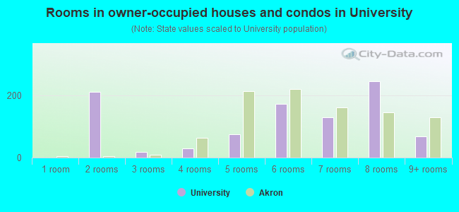
- Rooms in owner-occupied houses and condos in University
- 01 room
- 2122 rooms
- 193 rooms
- 294 rooms
- 755 rooms
- 1746 rooms
- 1297 rooms
- 2468 rooms
- 689+ rooms
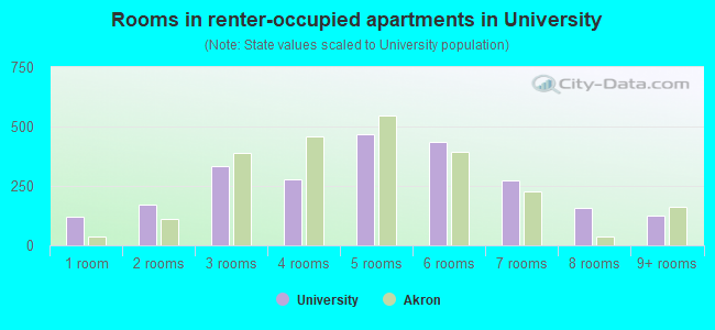
- Rooms in renter-occupied apartments in University
- 1201 room
- 1732 rooms
- 3323 rooms
- 2764 rooms
- 4685 rooms
- 4376 rooms
- 2757 rooms
- 1568 rooms
- 1279+ rooms
Owner-occupied
Renter-occupied
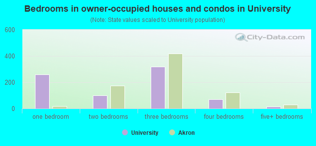
- Bedrooms in owner-occupied houses and condos in University
- 0no bedroom
- 2591 bedroom
- 1002 bedrooms
- 3203 bedrooms
- 694 bedrooms
- 155+ bedrooms
- Bedrooms in renter-occupied apartments in University
- 120no bedroom
- 5681 bedroom
- 5062 bedrooms
- 7033 bedrooms
- 2134 bedrooms
- 1855+ bedrooms
Average number of cars or other vehicles available in houses/condos:
Average number of cars or other vehicles available in apartments:
| This neighborhood: | 1.4 |
| Akron: | 1.7 |
Average number of cars or other vehicles available in apartments:
| Here: | 1.7 |
| city: | 1.1 |
Percentage of units with a mortgage:
| University: | 24.4% |
| Akron: | 55.4% |
Average estimated value of detached houses in 2022 (47.0% of all units):
| University: | $31,171 |
| Ohio: | $254,366 |
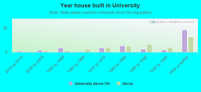
- Year house built in University
- 02020 or later
- 1062010 to 2019
- 1652000 to 2009
- 3481990 to 1999
- 601980 to 1989
- 3521970 to 1979
- 5311960 to 1969
- 2491950 to 1959
- 1721940 to 1949
- 1,8431939 or earlier
City-data.com crime index for city in 2020 (higher means more crime):
| City: | 481.4 |
| U.S. average: | 219.5 |
Travel time to work (commute)
![Travel time to work (commute)]()
- 84Less than 5 minutes
- 7365 to 9 minutes
- 46310 to 14 minutes
- 56415 to 19 minutes
- 42020 to 24 minutes
- 11925 to 29 minutes
- 38630 to 34 minutes
- 9135 to 39 minutes
- 11940 to 44 minutes
- 28845 to 59 minutes
- 15560 to 89 minutes
- 3690 or more minutes

Means of transportation to work
![Means of transportation to work]()
- 71.3%2,227Drove a car alone
- 11.9%372Carpooled
- 4.7%147Bus
- 3.4%105Taxi
- 3.2%100Walked
- 3.8%119Other means
- 13.6%426Worked at home

Time leaving home to go to work
![Time leaving home to go to work]()
- 12712:00 a.m. to 4:59 a.m.
- 2785:00 a.m. to 5:29 a.m.
- 965:30 a.m. to 5:59 a.m.
- 2316:00 a.m. to 6:29 a.m.
- 1646:30 a.m. to 6:59 a.m.
- 2867:00 a.m. to 7:29 a.m.
- 2427:30 a.m. to 7:59 a.m.
- 2518:00 a.m. to 8:29 a.m.
- 2398:30 a.m. to 8:59 a.m.
- 2779:00 a.m. to 9:59 a.m.
- 10010:00 a.m. to 10:59 a.m.
- 13311:00 a.m. to 11:59 a.m.
- 52312:00 p.m. to 3:59 p.m.
- 5764:00 p.m. to 11:59 p.m.

Occupations of males:
- Percentage of males in management occupations (except farmers):
Here: 4.7% city: 7.7%
- Percentage of males in business and financial operations occupations:
Here: 2.1% city: 3.7%
- Percentage of males in computer and mathematical occupations:
Here: 4.0% city: 3.1%
- Percentage of males in architecture and engineering occupations:
Here: 1.6% city: 3.0%
- Percentage of males in education, training, and library occupations:
Here: 4.9% city: 2.7%
- Percentage of males in service occupations:
Here: 21.6% city: 17.1%
- Percentage of males in sales and office occupations:
Here: 13.7% city: 14.8%
- Percentage of males in construction, extraction, and maintenance occupations:
Here: 10.5% city: 7.5%
- Percentage of males in production occupations:
Here: 14.2% city: 13.5%
- Percentage of males in transportation occupations:
Here: 3.7% city: 5.5%
- Percentage of males in material moving occupations:
Here: 13.4% city: 9.4%
Occupations of females:
- Percentage of females in management occupations (except farmers):
Here: 3.7% city: 7.5%
- Percentage of females in architecture and engineering occupations:
Here: 3.6% city: 0.4%
- Percentage of females in community and social services occupations:
Here: 2.5% city: 2.7%
- Percentage of females in education, training, and library occupations:
Here: 18.0% city: 6.7%
- Percentage of females in arts, design, entertainment, sports, and media occupations:
Here: 4.3% city: 1.8%
- Percentage of females in healthcare practitioners and technical occupations:
Here: 3.7% city: 8.2%
- Percentage of females in service occupations:
Here: 35.8% city: 26.6%
- Percentage of females in sales and office occupations:
Here: 19.5% city: 28.8%
- Percentage of females in construction, extraction, and maintenance occupations:
Here: 4.6% city: 0.3%
- Percentage of females in production occupations:
Here: 2.9% city: 4.5%
Education in this neighborhood (subdivision or community):
- Percentage of people 3 years and older in K-12 schools:
University: 21.8% Akron: 17.3%
- Percentage of people 3 years and older in undergraduate colleges:
University: 34.8% Akron: 5.4%
- Percentage of people 3 years and older in grad. or professional schools:
University: 7.5% Akron: 1.2%
- Percentage of students K-12 enrolled in private schools:
University: 61.1% Akron: 11.4%
Percentage of population below poverty level:
| University: | 46.2% |
| Akron: | 24.4% |
Median year renter moved in (as recorded in 2022):
| University: | 2016 |
| Akron: | 2019 |
Percentage of married-couple families with both working:
| University: | 116.7% |
| Akron: | 67.4% |
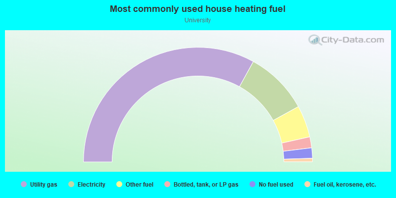
- 66.0%Utility gas
- 17.9%Electricity
- 9.0%Other fuel
- 3.1%Bottled, tank, or LP gas
- 2.9%No fuel used
- 1.0%Fuel oil, kerosene, etc.
Limited-access highways (interstate or state) in this neighborhood:
I- 77 (I- 76)
Length: 1.70 miles
Direction: E-W
Direction: E-W
I- 77
Length: 0.08 miles
Direction: N-S
Direction: N-S
Highways in this neighborhood:
State Rte 8
Length: 2.42 miles
Direction: N-S
Direction: N-S
Roads and streets:
E Exchange St
Length: 1.49 miles
Directions: E-W, SE-NW
Address range: 103 to 919
Directions: E-W, SE-NW
Address range: 103 to 919
E Buchtel Ave
Length: 1.15 miles
Directions: E-W, SE-NW
Address range: 200 to 653
Directions: E-W, SE-NW
Address range: 200 to 653
Spicer St
Length: 1.04 miles
Directions: N-S, SE-NW, SW-NE
Address range: 169 to 711
Directions: N-S, SE-NW, SW-NE
Address range: 169 to 711
Carroll St
Length: 1.03 miles
Directions: E-W, SW-NE
Address range: 100 to 669
Directions: E-W, SW-NE
Address range: 100 to 669
Brown St
Length: 0.78 miles
Direction: N-S
Address range: 370 to 790
Direction: N-S
Address range: 370 to 790
Goodkirk St
Length: 0.77 miles
Directions: E-W, N-S, SW-NE
Address range: 100 to 499
Directions: E-W, N-S, SW-NE
Address range: 100 to 499
Sherman St
Length: 0.76 miles
Directions: N-S, SW-NE
Address range: 300 to 749
Directions: N-S, SW-NE
Address range: 300 to 749
Wheeler St
Length: 0.75 miles
Directions: E-W, SE-NW
Address range: 100 to 358
Directions: E-W, SE-NW
Address range: 100 to 358
Sumner St
Length: 0.73 miles
Directions: N-S, SW-NE
Address range: 368 to 771
Directions: N-S, SW-NE
Address range: 368 to 771
Allyn St
Length: 0.71 miles
Directions: N-S, SW-NE
Address range: 359 to 748
Directions: N-S, SW-NE
Address range: 359 to 748
Fountain St
Length: 0.68 miles
Direction: N-S
Address range: 171 to 400
Direction: N-S
Address range: 171 to 400
Kling St
Length: 0.68 miles
Directions: N-S, SE-NW
Address range: 300 to 729
Directions: N-S, SE-NW
Address range: 300 to 729
Cross St
Length: 0.56 miles
Direction: E-W
Address range: 201 to 460
Direction: E-W
Address range: 201 to 460
E Thornton St
Length: 0.55 miles
Direction: E-W
Address range: 275 to 499
Direction: E-W
Address range: 275 to 499
Power St
Length: 0.51 miles
Direction: E-W
Address range: 215 to 460
Direction: E-W
Address range: 215 to 460
Johnston St
Length: 0.49 miles
Directions: E-W, SW-NE
Address range: 533 to 754
Directions: E-W, SW-NE
Address range: 533 to 754
E Voris St
Length: 0.46 miles
Direction: E-W
Address range: 280 to 470
Direction: E-W
Address range: 280 to 470
Crouse St
Length: 0.45 miles
Direction: E-W
Address range: 386 to 586
Direction: E-W
Address range: 386 to 586
Annadale Ave
Length: 0.38 miles
Direction: N-S
Address range: 77 to 270
Direction: N-S
Address range: 77 to 270
S Forge St
Length: 0.36 miles
Direction: E-W
Address range: 40 to 299
Direction: E-W
Address range: 40 to 299
Beacon St
Length: 0.36 miles
Directions: E-W, N-S, SW-NE
Address range: 474 to 599
Directions: E-W, N-S, SW-NE
Address range: 474 to 599
Excelsior Ave
Length: 0.35 miles
Directions: E-W, N-S, SE-NW
Address range: 659 to 802
Directions: E-W, N-S, SE-NW
Address range: 659 to 802
Vine St
Length: 0.34 miles
Direction: E-W
Address range: 379 to 520
Direction: E-W
Address range: 379 to 520
Beaver St
Length: 0.29 miles
Direction: N-S
Address range: 100 to 274
Direction: N-S
Address range: 100 to 274
S Union St
Length: 0.26 miles
Directions: N-S, SW-NE
Address range: 100 to 369
Directions: N-S, SW-NE
Address range: 100 to 369
E Mill St
Length: 0.26 miles
Directions: E-W, SE-NW
Address range: 179 to 299
Directions: E-W, SE-NW
Address range: 179 to 299
Lumiere St
Length: 0.25 miles
Directions: E-W, N-S, SE-NW
Address range: 553 to 577
Directions: E-W, N-S, SE-NW
Address range: 553 to 577
Grant St
Length: 0.23 miles
Directions: N-S, SW-NE
Address range: 300 to 594
Directions: N-S, SW-NE
Address range: 300 to 594
Fir Hill
Length: 0.23 miles
Directions: N-S, SW-NE
Address range: 37 to 198
Directions: N-S, SW-NE
Address range: 37 to 198
S College St
Length: 0.23 miles
Directions: N-S, SW-NE
Address range: 90 to 319
Directions: N-S, SW-NE
Address range: 90 to 319
Torrey St
Length: 0.22 miles
Directions: E-W, SE-NW
Address range: 229 to 330
Directions: E-W, SE-NW
Address range: 229 to 330
Wolf Ledges
Length: 0.20 miles
Directions: N-S, SW-NE
Address range: 200 to 289
Directions: N-S, SW-NE
Address range: 200 to 289
Wolf Ledges Pkwy
Length: 0.18 miles
Direction: SW-NE
Direction: SW-NE
Nash St
Length: 0.18 miles
Direction: E-W
Address range: 476 to 580
Direction: E-W
Address range: 476 to 580
Gage St
Length: 0.18 miles
Direction: E-W
Address range: 474 to 555
Direction: E-W
Address range: 474 to 555
Hammel St
Length: 0.18 miles
Directions: N-S, SE-NW, SW-NE
Address range: 460 to 557
Directions: N-S, SE-NW, SW-NE
Address range: 460 to 557
Bettie St
Length: 0.17 miles
Direction: N-S
Address range: 377 to 499
Direction: N-S
Address range: 377 to 499
Hazel Pl
Length: 0.17 miles
Directions: E-W, N-S, SE-NW
Address range: 520 to 563
Directions: E-W, N-S, SE-NW
Address range: 520 to 563
Kirn Ave
Length: 0.17 miles
Direction: N-S
Address range: 390 to 450
Direction: N-S
Address range: 390 to 450
Hill St
Length: 0.15 miles
Direction: SW-NE
Address range: 100 to 299
Direction: SW-NE
Address range: 100 to 299
S Adolph Ave
Length: 0.15 miles
Direction: N-S
Address range: 15 to 99
Direction: N-S
Address range: 15 to 99
University Ave
Length: 0.15 miles
Directions: E-W, SE-NW
Address range: 99 to 221
Directions: E-W, SE-NW
Address range: 99 to 221
Buchtel Mall
Length: 0.14 miles
Direction: E-W
Address range: 171 to 299
Direction: E-W
Address range: 171 to 299
Rentschler St
Length: 0.13 miles
Direction: N-S
Address range: 464 to 540
Direction: N-S
Address range: 464 to 540
Johnston Ct
Length: 0.13 miles
Direction: N-S
Address range: 450 to 641
Direction: N-S
Address range: 450 to 641
Wilson St
Length: 0.13 miles
Direction: N-S
Address range: 314 to 640
Direction: N-S
Address range: 314 to 640
Hedden Ave
Length: 0.12 miles
Directions: N-S, SE-NW
Address range: 450 to 640
Directions: N-S, SE-NW
Address range: 450 to 640
Hamilton Ave
Length: 0.12 miles
Direction: N-S
Address range: 1 to 130
Direction: N-S
Address range: 1 to 130
Lincoln St
Length: 0.12 miles
Direction: N-S
Address range: 80 to 139
Direction: N-S
Address range: 80 to 139
Rankin St
Length: 0.12 miles
Direction: E-W
Address range: 344 to 399
Direction: E-W
Address range: 344 to 399
Tyner St
Length: 0.12 miles
Direction: E-W
Address range: 400 to 460
Direction: E-W
Address range: 400 to 460
Huntington Ave
Length: 0.12 miles
Direction: N-S
Address range: 200 to 329
Direction: N-S
Address range: 200 to 329
Arc Dr
Length: 0.12 miles
Directions: E-W, SW-NE
Directions: E-W, SW-NE
Lamparter St
Length: 0.12 miles
Direction: E-W
Address range: 437 to 480
Direction: E-W
Address range: 437 to 480
Lovisa St
Length: 0.12 miles
Direction: E-W
Address range: 400 to 460
Direction: E-W
Address range: 400 to 460
Kathryn Pl
Length: 0.11 miles
Directions: N-S, SW-NE
Address range: 300 to 410
Directions: N-S, SW-NE
Address range: 300 to 410
Price Pl
Length: 0.10 miles
Direction: N-S
Address range: 80 to 139
Direction: N-S
Address range: 80 to 139
Bellewood Ct
Length: 0.10 miles
Direction: N-S
Direction: N-S
Sherman Ct
Length: 0.10 miles
Direction: E-W
Address range: 200 to 299
Direction: E-W
Address range: 200 to 299
Orchard St
Length: 0.10 miles
Direction: E-W
Address range: 450 to 499
Direction: E-W
Address range: 450 to 499
Walter Pl
Length: 0.10 miles
Direction: E-W
Address range: 326 to 360
Direction: E-W
Address range: 326 to 360
Bellewood Ave
Length: 0.10 miles
Direction: E-W
Address range: 258 to 299
Direction: E-W
Address range: 258 to 299
Minnie Ct
Length: 0.09 miles
Direction: E-W
Address range: 377 to 399
Direction: E-W
Address range: 377 to 399
E South St
Length: 0.09 miles
Directions: E-W, SW-NE
Address range: 488 to 599
Directions: E-W, SW-NE
Address range: 488 to 599
Kepner Ct
Length: 0.09 miles
Direction: E-W
Direction: E-W
Straw St (Straw Aly)
Length: 0.09 miles
Direction: N-S
Address range: 1 to 99
Direction: N-S
Address range: 1 to 99
Wise St
Length: 0.09 miles
Direction: N-S
Address range: 59 to 99
Direction: N-S
Address range: 59 to 99
Mason Ave
Length: 0.08 miles
Directions: E-W, SE-NW
Address range: 549 to 599
Directions: E-W, SE-NW
Address range: 549 to 599
Abbot Ct
Length: 0.07 miles
Direction: E-W
Address range: 419 to 460
Direction: E-W
Address range: 419 to 460
Sterling Ct
Length: 0.07 miles
Direction: E-W
Address range: 300 to 340
Direction: E-W
Address range: 300 to 340
Conmore Ct
Length: 0.06 miles
Direction: E-W
Address range: 384 to 420
Direction: E-W
Address range: 384 to 420
Bethwayne Ct
Length: 0.06 miles
Direction: E-W
Address range: 377 to 399
Direction: E-W
Address range: 377 to 399
Irisdale Pl
Length: 0.06 miles
Direction: E-W
Address range: 229 to 260
Direction: E-W
Address range: 229 to 260
Buckeye St
Length: 0.06 miles
Direction: N-S
Address range: 200 to 299
Direction: N-S
Address range: 200 to 299
Heimbaugh Ave
Length: 0.06 miles
Direction: N-S
Address range: 300 to 399
Direction: N-S
Address range: 300 to 399
Danville Ct
Length: 0.06 miles
Direction: E-W
Address range: 359 to 399
Direction: E-W
Address range: 359 to 399
Gage St Exn
Length: 0.06 miles
Direction: N-S
Address range: 600 to 650
Direction: N-S
Address range: 600 to 650
Valinda Pl
Length: 0.06 miles
Direction: E-W
Address range: 300 to 418
Direction: E-W
Address range: 300 to 418
Bridget St
Length: 0.06 miles
Direction: E-W
Address range: 713 to 730
Direction: E-W
Address range: 713 to 730
Pershing Ct
Length: 0.06 miles
Direction: E-W
Address range: 400 to 499
Direction: E-W
Address range: 400 to 499
S Adams St
Length: 0.05 miles
Direction: N-S
Address range: 60 to 78
Direction: N-S
Address range: 60 to 78
Duer Ct
Length: 0.05 miles
Direction: E-W
Address range: 270 to 299
Direction: E-W
Address range: 270 to 299
Sumner Ct
Length: 0.05 miles
Direction: E-W
Address range: 270 to 309
Direction: E-W
Address range: 270 to 309
Spruce St
Length: 0.05 miles
Direction: N-S
Address range: 45 to 70
Direction: N-S
Address range: 45 to 70
Harvey Ct
Length: 0.05 miles
Direction: E-W
Address range: 400 to 501
Direction: E-W
Address range: 400 to 501
Blanche Ct
Length: 0.05 miles
Direction: E-W
Address range: 477 to 499
Direction: E-W
Address range: 477 to 499
Beltz Ct
Length: 0.05 miles
Direction: E-W
Address range: 300 to 399
Direction: E-W
Address range: 300 to 399
Ewing Ct
Length: 0.05 miles
Direction: E-W
Address range: 390 to 437
Direction: E-W
Address range: 390 to 437
Gray Ct
Length: 0.05 miles
Direction: E-W
Address range: 400 to 461
Direction: E-W
Address range: 400 to 461
Moon Dr
Length: 0.05 miles
Direction: N-S
Address range: 358 to 380
Direction: N-S
Address range: 358 to 380
Leda Pl
Length: 0.05 miles
Direction: E-W
Address range: 500 to 515
Direction: E-W
Address range: 500 to 515
Roselawn Ave
Length: 0.04 miles
Direction: E-W
Address range: 793 to 820
Direction: E-W
Address range: 793 to 820
Mews Ct
Length: 0.04 miles
Direction: E-W
Direction: E-W
Cross Ct
Length: 0.04 miles
Direction: N-S
Address range: 557 to 599
Direction: N-S
Address range: 557 to 599
Arbawr Ct
Length: 0.04 miles
Direction: N-S
Address range: 287 to 329
Direction: N-S
Address range: 287 to 329
Angne Pl
Length: 0.04 miles
Direction: N-S
Address range: 379 to 419
Direction: N-S
Address range: 379 to 419
Greissing Ter
Length: 0.03 miles
Direction: N-S
Address range: 575 to 599
Direction: N-S
Address range: 575 to 599
Bertsch Ter
Length: 0.03 miles
Direction: N-S
Address range: 400 to 499
Direction: N-S
Address range: 400 to 499
Windsor St
Length: 0.03 miles
Direction: N-S
Address range: 200 to 208
Direction: N-S
Address range: 200 to 208
Railroad features:
Akron and Barberton Belt RR
Length: 0.00 miles
Direction: N-S
Direction: N-S