West End neighborhood in Alameda, California (CA), 94501 detailed profile
Settings
X


Business Search - 14 Million verified businesses
Area: 1.836 square miles
Population: 19,821
Population density:
| West End: | 10,795 people per square mile |
| Alameda: | 7,044 people per square mile |

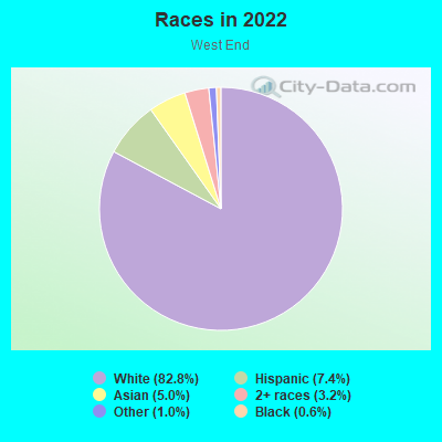
- 8,29337.4%White
- 6,50329.4%Asian
- 2,71512.3%Hispanic or Latino
- 1,5076.8%Black
- 1,0544.8%Native Hawaiian and Other
Pacific Islander - 1,0534.8%Two or more races
- 6813.1%American Indian
- 3411.5%Some other race
Distribution of median household income
![Distribution of median household income]()
- 457Less than $10,000
- 1,201$10,000 to $19,999
- 818$20,000 to $29,999
- 894$30,000 to $39,999
- 733$40,000 to $49,999
- 591$50,000 to $59,999
- 740$60,000 to $74,999
- 1,018$75,000 to $99,999
- 800$100,000 to $124,999
- 522$125,000 to $149,999
- 1,161$150,000 to $199,999
- 1,871$200,000 or more

Distribution of owner-occupied house/condo value
![Distribution of owner-occupied house/condo value]()
- 250Less than $50,000
- 380$50,000 to $99,999
- 80$100,000 to $149,999
- 83$200,000 to $249,999
- 356$250,000 to $299,999
- 25$300,000 to $399,999
- 160$400,000 to $499,999
- 490$500,000 to $749,999
- 965$750,000 to $999,999
- 1,509$1,000,000 or more

Distribution of rent paid by renters
![Distribution of rent paid by renters]()
- 26Less than $100
- 9$100 to $199
- 1,249$200 to $299
- 1,703$300 to $399
- 330$400 to $499
- 581$500 to $599
- 377$600 to $699
- 1,061$700 to $799
- 455$800 to $899
- 228$900 to $999
- 447$1,000 to $1,249
- 673$1,250 to $1,499
- 1,403$1,500 to $1,999
- 3,961$2,000 or more

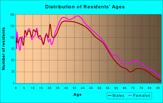
| Males: | 10,220 |
| Females: | 9,600 |
Males:
| This neighborhood: | 39.6 years |
| Whole city: | 40.2 years |
| This neighborhood: | 41.5 years |
| Whole city: | 41.8 years |
Average household size:
| West End: | 5.5 people |
| Alameda: | 2.7 people |
Percentage of family households:
| West End: | 40.8% |
| Alameda: | 45.6% |
| Here: | 39.0% |
| Alameda: | 52.5% |
Percentage of married-couple families with children (among all households):
| West End: | 32.3% |
| Alameda: | 29.2% |
Percentage of single-mother households (among all households):
| West End: | 10.7% |
| Alameda: | 5.9% |
Percentage of never married males 15 years old and over:
Percentage of never married females 15 years old and over:
| West End: | 21.9% |
| Alameda: | 14.3% |
Percentage of never married females 15 years old and over:
| West End: | 17.7% |
| city: | 17.4% |
Percentage of people that speak English not well or not at all:
| West End: | 4.9% |
| Alameda: | 4.7% |
Percentage of people born in this state:
Percentage of people born in another U.S. state:
Percentage of native residents but born outside the U.S.:
Percentage of foreign born residents:
| Here: | 48.2% |
| Alameda: | 50.2% |
Percentage of people born in another U.S. state:
| West End: | 19.0% |
| Alameda: | 19.2% |
Percentage of native residents but born outside the U.S.:
| Here: | 2.5% |
| city: | 2.3% |
Percentage of foreign born residents:
| Here: | 30.4% |
| Alameda: | 28.4% |
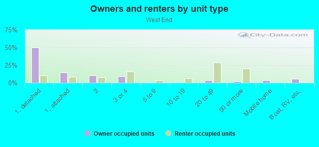
Owner-occupied
Renter-occupied

- Rooms in owner-occupied houses and condos in West End
- 121 room
- 1262 rooms
- 2883 rooms
- 6034 rooms
- 7855 rooms
- 6426 rooms
- 4617 rooms
- 2378 rooms
- 3829+ rooms
- Rooms in renter-occupied apartments in West End
- 4861 room
- 1,1802 rooms
- 1,7603 rooms
- 1,7974 rooms
- 6365 rooms
- 3486 rooms
- 2317 rooms
- 8018 rooms
- 179+ rooms
Owner-occupied
Renter-occupied
- Bedrooms in owner-occupied houses and condos in West End
- 148no bedroom
- 3281 bedroom
- 1,0342 bedrooms
- 1,0873 bedrooms
- 3924 bedrooms
- 3555+ bedrooms
- Bedrooms in renter-occupied apartments in West End
- 692no bedroom
- 2,6121 bedroom
- 2,0792 bedrooms
- 7353 bedrooms
- 2034 bedrooms
- 2105+ bedrooms
Average number of cars or other vehicles available in houses/condos:
Average number of cars or other vehicles available in apartments:
| This neighborhood: | 1.7 |
| Alameda: | 2.0 |
Average number of cars or other vehicles available in apartments:
| Here: | 1.3 |
| city: | 1.4 |
Percentage of units with a mortgage:
| West End: | 67.6% |
| Alameda: | 68.4% |
Average estimated value of detached houses in 2022 (32.7% of all units):
| West End: | $1,170,626 |
| California: | $988,808 |
- Year house built in West End
- 4862020 or later
- 4402010 to 2019
- 6942000 to 2009
- 7421990 to 1999
- 7531980 to 1989
- 1,1661970 to 1979
- 1,3381960 to 1969
- 1,1381950 to 1959
- 6281940 to 1949
- 3,6271939 or earlier
City-data.com crime index for city in 2020 (higher means more crime):
| City: | 236.5 |
| U.S. average: | 219.5 |
Travel time to work (commute)
![Travel time to work (commute)]()
- 149Less than 5 minutes
- 6845 to 9 minutes
- 75310 to 14 minutes
- 1,12615 to 19 minutes
- 1,46220 to 24 minutes
- 52525 to 29 minutes
- 1,26030 to 34 minutes
- 19135 to 39 minutes
- 79340 to 44 minutes
- 91245 to 59 minutes
- 78960 to 89 minutes
- 50890 or more minutes

Means of transportation to work
![Means of transportation to work]()
- 54.9%5,911Drove a car alone
- 8.1%872Carpooled
- 6.1%657Bus
- 4.3%462Subway or elevated rail
- 13.6%1,459Light rail, streetcar or trolley
- 4.9%528Ferryboat
- 3.9%421Taxi
- 1.5%163Motorcycle
- 3.0%321Bicycle
- 4.7%509Walked
- 2.5%266Other means
- 20.8%2,240Worked at home

Time leaving home to go to work
![Time leaving home to go to work]()
- 22812:00 a.m. to 4:59 a.m.
- 1025:00 a.m. to 5:29 a.m.
- 2555:30 a.m. to 5:59 a.m.
- 5286:00 a.m. to 6:29 a.m.
- 8556:30 a.m. to 6:59 a.m.
- 8547:00 a.m. to 7:29 a.m.
- 1,1627:30 a.m. to 7:59 a.m.
- 1,3818:00 a.m. to 8:29 a.m.
- 6058:30 a.m. to 8:59 a.m.
- 1,1699:00 a.m. to 9:59 a.m.
- 52810:00 a.m. to 10:59 a.m.
- 19711:00 a.m. to 11:59 a.m.
- 72512:00 p.m. to 3:59 p.m.
- 3144:00 p.m. to 11:59 p.m.

Occupations of males:
- Percentage of males in management occupations (except farmers):
Here: 12.9% city: 17.8%
- Percentage of males in business and financial operations occupations:
Here: 4.2% city: 7.3%
- Percentage of males in computer and mathematical occupations:
Here: 13.0% city: 9.1%
- Percentage of males in architecture and engineering occupations:
Here: 5.2% city: 6.4%
- Percentage of males in life, physical, and social science occupations:
Here: 3.9% city: 2.4%
- Percentage of males in education, training, and library occupations:
Here: 4.1% city: 4.8%
- Percentage of males in arts, design, entertainment, sports, and media occupations:
Here: 6.0% city: 5.3%
- Percentage of males in healthcare practitioners and technical occupations:
Here: 3.8% city: 4.0%
- Percentage of males in service occupations:
Here: 9.8% city: 9.9%
- Percentage of males in sales and office occupations:
Here: 16.7% city: 14.7%
- Percentage of males in construction, extraction, and maintenance occupations:
Here: 2.2% city: 2.1%
- Percentage of males in transportation occupations:
Here: 9.8% city: 5.8%
- Percentage of males in material moving occupations:
Here: 2.9% city: 2.3%
Occupations of females:
- Percentage of females in management occupations (except farmers):
Here: 13.9% city: 14.4%
- Percentage of females in business and financial operations occupations:
Here: 6.9% city: 10.6%
- Percentage of females in computer and mathematical occupations:
Here: 3.1% city: 3.7%
- Percentage of females in architecture and engineering occupations:
Here: 3.7% city: 2.9%
- Percentage of females in life, physical, and social science occupations:
Here: 4.7% city: 3.2%
- Percentage of females in community and social services occupations:
Here: 2.3% city: 2.2%
- Percentage of females in legal occupations:
Here: 1.5% city: 2.5%
- Percentage of females in education, training, and library occupations:
Here: 5.0% city: 8.3%
- Percentage of females in arts, design, entertainment, sports, and media occupations:
Here: 6.5% city: 4.9%
- Percentage of females in healthcare practitioners and technical occupations:
Here: 10.0% city: 8.9%
- Percentage of females in service occupations:
Here: 12.6% city: 13.8%
- Percentage of females in sales and office occupations:
Here: 20.6% city: 20.0%
- Percentage of females in production occupations:
Here: 3.8% city: 2.2%
- Percentage of females in transportation occupations:
Here: 1.1% city: 0.8%
- Percentage of females in material moving occupations:
Here: 3.6% city: 1.3%
Percentage of people 16-64 in Armed Forces:
| West End: | 0.3% |
| Alameda: | 1.1% |
Education in this neighborhood (subdivision or community):
- Percentage of people 3 years and older in K-12 schools:
West End: 22.7% Alameda: 16.7%
- Percentage of people 3 years and older in undergraduate colleges:
West End: 8.0% Alameda: 5.5%
- Percentage of people 3 years and older in grad. or professional schools:
West End: 5.3% Alameda: 3.4%
- Percentage of students K-12 enrolled in private schools:
West End: 55.7% Alameda: 12.4%
Percentage of population below poverty level:
| West End: | 10.3% |
| Alameda: | 9.3% |
Median year owner moved in (as recorded in 2022):
Median year renter moved in (as recorded in 2022):
| West End: | 2005 |
| Alameda: | 2008 |
Median year renter moved in (as recorded in 2022):
| West End: | 2015 |
| Alameda: | 2019 |
Percentage of married-couple families with both working:
| West End: | 85.7% |
| Alameda: | 80.1% |
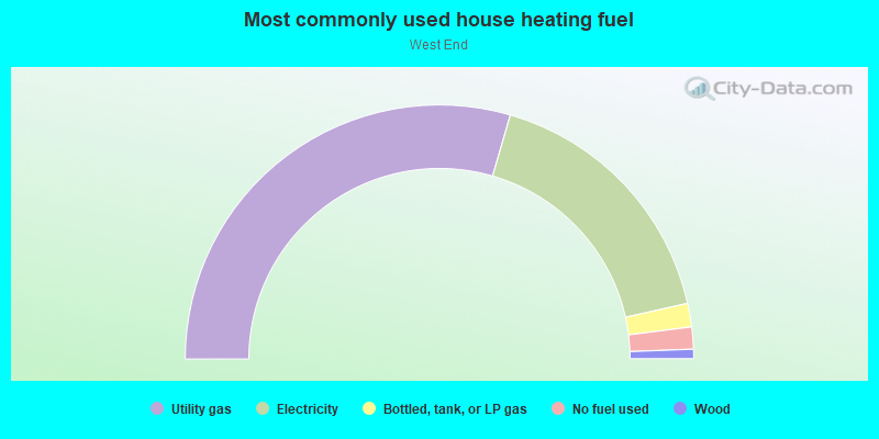
- 59.0%Utility gas
- 34.0%Electricity
- 3.0%Bottled, tank, or LP gas
- 2.8%No fuel used
- 1.2%Wood
Limited-access highways (interstate or state) in this neighborhood:
State Hwy 260 (Webster St Tube)
Length: 0.23 miles
Directions: E-W, N-S, SW-NE
Directions: E-W, N-S, SW-NE
Highways in this neighborhood:
State Hwy 260 (State Rte 260)
Length: 0.29 miles
Directions: N-S, SE-NW
Address range: 2154 to 2393
Directions: N-S, SE-NW
Address range: 2154 to 2393
Roads and streets:
Lincoln Ave
Length: 3.23 miles
Directions: E-W, SW-NE
Address range: 100 to 1299
Directions: E-W, SW-NE
Address range: 100 to 1299
Santa Clara Ave
Length: 3.01 miles
Directions: E-W, N-S, SE-NW, SW-NE
Address range: 100 to 1299
Directions: E-W, N-S, SE-NW, SW-NE
Address range: 100 to 1299
Buena Vista Ave
Length: 2.52 miles
Directions: E-W, SE-NW
Address range: 400 to 1299
Directions: E-W, SE-NW
Address range: 400 to 1299
Pacific Ave
Length: 2.32 miles
Direction: E-W
Address range: 100 to 1299
Direction: E-W
Address range: 100 to 1299
Atlantic Ave
Length: 2.13 miles
Direction: E-W
Address range: 110 to 803
Direction: E-W
Address range: 110 to 803
Central Ave
Length: 2.06 miles
Directions: E-W, N-S, SE-NW, SW-NE
Address range: 139 to 799
Directions: E-W, N-S, SE-NW, SW-NE
Address range: 139 to 799
Webster St
Length: 1.71 miles
Directions: E-W, N-S, SE-NW
Address range: 1300 to 2225
Directions: E-W, N-S, SE-NW
Address range: 1300 to 2225
Taylor Ave
Length: 1.56 miles
Direction: E-W
Address range: 300 to 1099
Direction: E-W
Address range: 300 to 1099
Constitution Way
Length: 1.55 miles
Directions: N-S, SE-NW, SW-NE
Directions: N-S, SE-NW, SW-NE
Haight Ave
Length: 1.40 miles
Directions: E-W, N-S, SE-NW
Address range: 100 to 899
Directions: E-W, N-S, SE-NW
Address range: 100 to 899
Mosley Ave
Length: 1.16 miles
Directions: E-W, N-S, SE-NW, SW-NE
Address range: 1 to 501
Directions: E-W, N-S, SE-NW, SW-NE
Address range: 1 to 501
8th St
Length: 1.07 miles
Directions: N-S, SE-NW, SW-NE
Address range: 1300 to 1899
Directions: N-S, SE-NW, SW-NE
Address range: 1300 to 1899
5th St
Length: 0.77 miles
Directions: N-S, SW-NE
Address range: 1400 to 1799
Directions: N-S, SW-NE
Address range: 1400 to 1799
Eagle Ave
Length: 0.76 miles
Direction: E-W
Address range: 600 to 1293
Direction: E-W
Address range: 600 to 1293
3rd St
Length: 0.66 miles
Directions: E-W, N-S, SW-NE
Address range: 1300 to 1999
Directions: E-W, N-S, SW-NE
Address range: 1300 to 1999
Tinker Ave
Length: 0.63 miles
Direction: E-W
Direction: E-W
Westline Dr
Length: 0.60 miles
Directions: N-S, SE-NW
Address range: 300 to 699
Directions: N-S, SE-NW
Address range: 300 to 699
Mulvany Cir
Length: 0.56 miles
Directions: E-W, N-S, SE-NW, SW-NE
Directions: E-W, N-S, SE-NW, SW-NE
Hollister Ave
Length: 0.53 miles
Direction: E-W
Direction: E-W
Sherman St
Length: 0.53 miles
Direction: N-S
Address range: 1400 to 1839
Direction: N-S
Address range: 1400 to 1839
Mariner Sq Lp
Length: 0.51 miles
Directions: E-W, N-S, SE-NW, SW-NE
Address range: 2100 to 2499
Directions: E-W, N-S, SE-NW, SW-NE
Address range: 2100 to 2499
Mariner Square Dr
Length: 0.50 miles
Directions: N-S, SE-NW, SW-NE
Address range: 2100 to 2499
Directions: N-S, SE-NW, SW-NE
Address range: 2100 to 2499
St Charles St
Length: 0.47 miles
Directions: N-S, SE-NW
Address range: 1446 to 1899
Directions: N-S, SE-NW
Address range: 1446 to 1899
4th St
Length: 0.46 miles
Directions: N-S, SE-NW, SW-NE
Address range: 1300 to 1699
Directions: N-S, SE-NW, SW-NE
Address range: 1300 to 1699
9th St
Length: 0.46 miles
Direction: N-S
Address range: 1429 to 1899
Direction: N-S
Address range: 1429 to 1899
Marshall Way
Length: 0.41 miles
Direction: E-W
Address range: 400 to 499
Direction: E-W
Address range: 400 to 499
Jack London Ave
Length: 0.41 miles
Direction: E-W
Direction: E-W
Singleton Ave
Length: 0.39 miles
Directions: E-W, SW-NE
Address range: 101 to 299
Directions: E-W, SW-NE
Address range: 101 to 299
Robert Louis Stevenson Ave
Length: 0.39 miles
Direction: E-W
Direction: E-W
Bryant Ave
Length: 0.39 miles
Direction: E-W
Direction: E-W
Cimarron St
Length: 0.37 miles
Directions: E-W, SE-NW
Directions: E-W, SE-NW
Bay St
Length: 0.37 miles
Direction: N-S
Address range: 1500 to 1999
Direction: N-S
Address range: 1500 to 1999
Coral Sea St
Length: 0.36 miles
Directions: N-S, SE-NW, SW-NE
Directions: N-S, SE-NW, SW-NE
Ansel Ave
Length: 0.35 miles
Direction: E-W
Direction: E-W
6th St
Length: 0.33 miles
Direction: N-S
Address range: 1400 to 1699
Direction: N-S
Address range: 1400 to 1699
Cypress St
Length: 0.33 miles
Directions: E-W, SE-NW
Address range: 100 to 399
Directions: E-W, SE-NW
Address range: 100 to 399
Tideway Dr
Length: 0.32 miles
Directions: E-W, N-S, SE-NW, SW-NE
Address range: 300 to 599
Directions: E-W, N-S, SE-NW, SW-NE
Address range: 300 to 599
Dunlin Ln
Length: 0.31 miles
Directions: E-W, N-S
Directions: E-W, N-S
Glenview St
Length: 0.30 miles
Direction: N-S
Direction: N-S
Wood St
Length: 0.29 miles
Direction: N-S
Address range: 1600 to 1899
Direction: N-S
Address range: 1600 to 1899
Brush St
Length: 0.28 miles
Direction: E-W
Address range: 100 to 399
Direction: E-W
Address range: 100 to 399
Lina Ave
Length: 0.28 miles
Direction: E-W
Direction: E-W
Chapin St
Length: 0.27 miles
Direction: N-S
Address range: 1600 to 1899
Direction: N-S
Address range: 1600 to 1899
Tucker Ave
Length: 0.24 miles
Direction: E-W
Direction: E-W
Mitchell Ave
Length: 0.24 miles
Direction: E-W
Direction: E-W
Decatur Ln
Length: 0.24 miles
Directions: E-W, N-S
Directions: E-W, N-S
McKay Ave
Length: 0.22 miles
Direction: N-S
Address range: 1200 to 1399
Direction: N-S
Address range: 1200 to 1399
Crown Dr
Length: 0.21 miles
Directions: N-S, SE-NW, SW-NE
Address range: 1300 to 1399
Directions: N-S, SE-NW, SW-NE
Address range: 1300 to 1399
Kollmann Cir
Length: 0.21 miles
Directions: E-W, N-S, SW-NE
Address range: 200 to 2016
Directions: E-W, N-S, SW-NE
Address range: 200 to 2016
Crolls Garden Ct
Length: 0.21 miles
Directions: E-W, N-S
Address range: 100 to 399
Directions: E-W, N-S
Address range: 100 to 399
Schroeder Ln
Length: 0.21 miles
Directions: E-W, N-S
Directions: E-W, N-S
Monterey Cir
Length: 0.20 miles
Directions: E-W, N-S, SW-NE
Address range: 200 to 20010
Directions: E-W, N-S, SW-NE
Address range: 200 to 20010
Dowling Ln
Length: 0.20 miles
Directions: E-W, N-S
Directions: E-W, N-S
Nason St
Length: 0.19 miles
Direction: N-S
Address range: 1700 to 1899
Direction: N-S
Address range: 1700 to 1899
Kingfisher Ave
Length: 0.18 miles
Direction: E-W
Direction: E-W
Emeric Ln
Length: 0.18 miles
Directions: E-W, N-S
Directions: E-W, N-S
Poggi St
Length: 0.18 miles
Directions: N-S, SE-NW
Address range: 1800 to 1999
Directions: N-S, SE-NW
Address range: 1800 to 1999
Arkansas
Length: 0.17 miles
Directions: E-W, N-S, SE-NW
Address range: 3001 to 3019
Directions: E-W, N-S, SE-NW
Address range: 3001 to 3019
Hatfield Ln
Length: 0.17 miles
Directions: E-W, N-S, SW-NE
Directions: E-W, N-S, SW-NE
Annapolis Cir
Length: 0.17 miles
Directions: E-W, N-S, SE-NW, SW-NE
Address range: 2000 to 2099
Directions: E-W, N-S, SE-NW, SW-NE
Address range: 2000 to 2099
Maple Way
Length: 0.17 miles
Directions: E-W, N-S
Address range: 100 to 299
Directions: E-W, N-S
Address range: 100 to 299
Haile St
Length: 0.16 miles
Direction: N-S
Direction: N-S
Chipman St
Length: 0.16 miles
Direction: N-S
Direction: N-S
Marina Village Pkwy
Length: 0.16 miles
Directions: E-W, SE-NW
Directions: E-W, SE-NW
Water Works Ln
Length: 0.15 miles
Directions: E-W, N-S
Directions: E-W, N-S
Concordia St
Length: 0.14 miles
Direction: N-S
Address range: 1600 to 1799
Direction: N-S
Address range: 1600 to 1799
Cotati Ln
Length: 0.14 miles
Directions: E-W, N-S, SE-NW, SW-NE
Directions: E-W, N-S, SE-NW, SW-NE
Neptune Gardens Ave
Length: 0.14 miles
Direction: E-W
Direction: E-W
Hamilton Ln
Length: 0.13 miles
Directions: E-W, N-S, SW-NE
Directions: E-W, N-S, SW-NE
Verdi St
Length: 0.13 miles
Direction: N-S
Address range: 1500 to 1599
Direction: N-S
Address range: 1500 to 1599
Mozart St
Length: 0.13 miles
Direction: N-S
Address range: 1500 to 1599
Direction: N-S
Address range: 1500 to 1599
Linden St
Length: 0.13 miles
Direction: N-S
Address range: 1500 to 1599
Direction: N-S
Address range: 1500 to 1599
Percy Ln
Length: 0.13 miles
Directions: E-W, N-S, SE-NW
Directions: E-W, N-S, SE-NW
Mars
Length: 0.13 miles
Directions: E-W, N-S, SE-NW
Address range: 3033 to 3039
Directions: E-W, N-S, SE-NW
Address range: 3033 to 3039
Greenwald Ln
Length: 0.13 miles
Direction: N-S
Direction: N-S
Queen's Rd
Length: 0.13 miles
Directions: E-W, N-S, SE-NW, SW-NE
Address range: 500 to 599
Directions: E-W, N-S, SE-NW, SW-NE
Address range: 500 to 599
Page St
Length: 0.13 miles
Direction: N-S
Address range: 1400 to 1499
Direction: N-S
Address range: 1400 to 1499
Stewart Ct
Length: 0.13 miles
Direction: E-W
Address range: 700 to 799
Direction: E-W
Address range: 700 to 799
Mayport Cir
Length: 0.13 miles
Directions: E-W, N-S, SW-NE
Address range: 2002 to 2099
Directions: E-W, N-S, SW-NE
Address range: 2002 to 2099
Ballena Blvd
Length: 0.13 miles
Directions: N-S, SW-NE
Directions: N-S, SW-NE
Portola Ave
Length: 0.13 miles
Directions: E-W, SE-NW
Address range: 800 to 899
Directions: E-W, SE-NW
Address range: 800 to 899
Bruzzone Dr
Length: 0.13 miles
Direction: N-S
Direction: N-S
Gresham Dr
Length: 0.13 miles
Directions: N-S, SW-NE
Address range: 1800 to 1999
Directions: N-S, SW-NE
Address range: 1800 to 1999
Memphis Ln
Length: 0.12 miles
Directions: E-W, N-S
Directions: E-W, N-S
Tern Ln
Length: 0.12 miles
Directions: E-W, SE-NW
Address range: 600 to 699
Directions: E-W, SE-NW
Address range: 600 to 699
Palace Ct
Length: 0.12 miles
Direction: E-W
Address range: 500 to 599
Direction: E-W
Address range: 500 to 599
King's Rd
Length: 0.12 miles
Directions: E-W, N-S
Address range: 500 to 599
Directions: E-W, N-S
Address range: 500 to 599
Mallard Ln
Length: 0.12 miles
Directions: E-W, N-S, SE-NW
Directions: E-W, N-S, SE-NW
Ohio
Length: 0.12 miles
Directions: E-W, N-S, SE-NW
Address range: 4087 to 4101
Directions: E-W, N-S, SE-NW
Address range: 4087 to 4101
Texas
Length: 0.12 miles
Directions: E-W, N-S, SE-NW, SW-NE
Address range: 3028 to 3032
Directions: E-W, N-S, SE-NW, SW-NE
Address range: 3028 to 3032
Flint
Length: 0.11 miles
Directions: N-S, SE-NW
Address range: 3054 to 3061
Directions: N-S, SE-NW
Address range: 3054 to 3061
Red Jacket Ln
Length: 0.11 miles
Directions: E-W, N-S
Directions: E-W, N-S
Sea Horse
Length: 0.11 miles
Directions: E-W, N-S, SW-NE
Address range: 4000 to 4099
Directions: E-W, N-S, SW-NE
Address range: 4000 to 4099
Norfolk Ave
Length: 0.11 miles
Directions: E-W, N-S, SW-NE
Directions: E-W, N-S, SW-NE
Pomeroy Ln
Length: 0.11 miles
Directions: E-W, N-S, SW-NE
Directions: E-W, N-S, SW-NE
Oceana St
Length: 0.11 miles
Direction: N-S
Direction: N-S
Seagull Ln
Length: 0.11 miles
Directions: E-W, N-S, SW-NE
Directions: E-W, N-S, SW-NE
Vernalis Ln
Length: 0.11 miles
Directions: E-W, N-S, SE-NW
Directions: E-W, N-S, SE-NW
California
Length: 0.11 miles
Directions: E-W, N-S
Address range: 3000 to 3099
Directions: E-W, N-S
Address range: 3000 to 3099
Dufour Ln
Length: 0.11 miles
Directions: E-W, N-S, SE-NW
Directions: E-W, N-S, SE-NW
2nd St
Length: 0.10 miles
Directions: N-S, SW-NE
Address range: 1700 to 1849
Directions: N-S, SW-NE
Address range: 1700 to 1849
Gilman Ln
Length: 0.10 miles
Directions: E-W, N-S, SW-NE
Directions: E-W, N-S, SW-NE
Seeback Ln
Length: 0.10 miles
Directions: E-W, N-S
Directions: E-W, N-S
Roth Ln
Length: 0.10 miles
Directions: E-W, N-S
Directions: E-W, N-S
Mount Hood
Length: 0.09 miles
Direction: E-W
Address range: 4000 to 4099
Direction: E-W
Address range: 4000 to 4099
Cormorant Ln
Length: 0.09 miles
Directions: E-W, N-S, SW-NE
Directions: E-W, N-S, SW-NE
Jouett Sq
Length: 0.08 miles
Direction: E-W
Direction: E-W
Sweeney Ln
Length: 0.08 miles
Directions: E-W, N-S, SE-NW
Directions: E-W, N-S, SE-NW
Kirk
Length: 0.08 miles
Direction: E-W
Address range: 4060 to 4063
Direction: E-W
Address range: 4060 to 4063
Spruce St
Length: 0.08 miles
Direction: E-W
Address range: 300 to 399
Direction: E-W
Address range: 300 to 399
Santa Rosa Ln
Length: 0.07 miles
Directions: E-W, N-S, SE-NW
Directions: E-W, N-S, SE-NW
Esterbrook Ct
Length: 0.07 miles
Direction: E-W
Address range: 700 to 799
Direction: E-W
Address range: 700 to 799
Mastick Ct
Length: 0.07 miles
Direction: N-S
Address range: 1 to 99
Direction: N-S
Address range: 1 to 99
Marion Ct
Length: 0.06 miles
Direction: E-W
Address range: 400 to 499
Direction: E-W
Address range: 400 to 499
Caroline St
Length: 0.06 miles
Direction: N-S
Address range: 1432 to 1499
Direction: N-S
Address range: 1432 to 1499
Carl Vinson
Length: 0.06 miles
Direction: E-W
Direction: E-W
Nimitz Dr
Length: 0.06 miles
Directions: E-W, SE-NW
Address range: 4001 to 4099
Directions: E-W, SE-NW
Address range: 4001 to 4099
Thau Way
Length: 0.06 miles
Direction: N-S
Address range: 1800 to 1902
Direction: N-S
Address range: 1800 to 1902
Roanoke Dr (Roark)
Length: 0.06 miles
Directions: N-S, SE-NW
Address range: 4000 to 4099
Directions: N-S, SE-NW
Address range: 4000 to 4099
Cole Ln
Length: 0.06 miles
Directions: E-W, N-S, SW-NE
Directions: E-W, N-S, SW-NE
Bertero Sq
Length: 0.05 miles
Direction: E-W
Direction: E-W
Kinkaid Sq
Length: 0.05 miles
Direction: E-W
Direction: E-W
Wichita
Length: 0.05 miles
Directions: N-S, SE-NW
Address range: 3000 to 3099
Directions: N-S, SE-NW
Address range: 3000 to 3099
Railroad Ln
Length: 0.05 miles
Directions: E-W, N-S
Directions: E-W, N-S
Enterprise
Length: 0.05 miles
Direction: E-W
Address range: 3000 to 3099
Direction: E-W
Address range: 3000 to 3099
W Campus Dr
Length: 0.05 miles
Direction: N-S
Direction: N-S
Shasta
Length: 0.05 miles
Directions: N-S, SW-NE
Address range: 3046 to 3053
Directions: N-S, SW-NE
Address range: 3046 to 3053
Fallon Ln
Length: 0.05 miles
Direction: N-S
Direction: N-S
Lakehurst Cir
Length: 0.05 miles
Directions: E-W, N-S, SW-NE
Address range: 2000 to 20008
Directions: E-W, N-S, SW-NE
Address range: 2000 to 20008
Bainbridge Sq
Length: 0.05 miles
Direction: E-W
Direction: E-W
Siegfried Ln
Length: 0.05 miles
Direction: N-S
Direction: N-S
Pickrell Sq
Length: 0.05 miles
Direction: E-W
Direction: E-W
Fulton Ln
Length: 0.05 miles
Direction: N-S
Direction: N-S
Chicago
Length: 0.04 miles
Direction: N-S
Address range: 4027 to 4042
Direction: N-S
Address range: 4027 to 4042
Pyro
Length: 0.04 miles
Directions: N-S, SE-NW
Address range: 3040 to 3045
Directions: N-S, SE-NW
Address range: 3040 to 3045
Teal Ln
Length: 0.04 miles
Direction: N-S
Direction: N-S
Kansas City
Length: 0.04 miles
Direction: N-S
Address range: 3062 to 3069
Direction: N-S
Address range: 3062 to 3069
Sacramento
Length: 0.04 miles
Direction: N-S
Address range: 4023 to 4029
Direction: N-S
Address range: 4023 to 4029
Tuttle Ln
Length: 0.04 miles
Direction: N-S
Direction: N-S
Spalding Sq
Length: 0.04 miles
Direction: E-W
Direction: E-W
Hoover Ct
Length: 0.04 miles
Direction: N-S
Address range: 1400 to 1499
Direction: N-S
Address range: 1400 to 1499
Kiska
Length: 0.04 miles
Direction: N-S
Address range: 4038 to 4043
Direction: N-S
Address range: 4038 to 4043
Bainbridge Ct
Length: 0.04 miles
Direction: E-W
Direction: E-W
Dolphin Ct
Length: 0.04 miles
Direction: N-S
Direction: N-S
Tynan Ave
Length: 0.04 miles
Direction: E-W
Direction: E-W
Garden Way
Length: 0.04 miles
Direction: N-S
Direction: N-S
Matson Ln
Length: 0.04 miles
Direction: E-W
Direction: E-W
Drum
Length: 0.04 miles
Direction: N-S
Address range: 4054 to 4059
Direction: N-S
Address range: 4054 to 4059
Nevada
Length: 0.03 miles
Directions: N-S, SW-NE
Address range: 4048 to 4053
Directions: N-S, SW-NE
Address range: 4048 to 4053
Cornelius Sq
Length: 0.03 miles
Direction: E-W
Direction: E-W
Sanderling Ct
Length: 0.03 miles
Direction: E-W
Direction: E-W
Wright Ln
Length: 0.03 miles
Direction: N-S
Direction: N-S
Kinkaid Ct
Length: 0.03 miles
Direction: E-W
Direction: E-W
Tripoli
Length: 0.03 miles
Direction: N-S
Address range: 4044 to 4047
Direction: N-S
Address range: 4044 to 4047
Killdeer Ct
Length: 0.03 miles
Direction: E-W
Address range: 1 to 99
Direction: E-W
Address range: 1 to 99
Bertero Ct
Length: 0.03 miles
Direction: E-W
Direction: E-W
Whimbrel Ct
Length: 0.03 miles
Direction: E-W
Address range: 2 to 99
Direction: E-W
Address range: 2 to 99
Willet Ct
Length: 0.03 miles
Direction: N-S
Address range: 1 to 99
Direction: N-S
Address range: 1 to 99
Pelican Ct
Length: 0.02 miles
Direction: N-S
Direction: N-S
Plover Ct
Length: 0.02 miles
Direction: E-W
Direction: E-W
Egret Ct
Length: 0.02 miles
Direction: E-W
Direction: E-W
Cotati St
Length: 0.01 miles
Direction: N-S
Direction: N-S