West Side neighborhood in Jersey City, New Jersey (NJ), 07304, 07306 detailed profile
Settings
X


Business Search - 14 Million verified businesses
Area: 2.093 square miles
Population: 28,125
Population density:
| West Side: | 13,440 people per square mile |
| Jersey City: | 19,218 people per square mile |

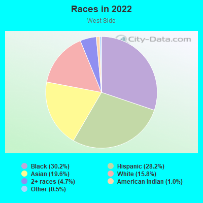
- 8,87230.2%Black
- 8,27528.2%Hispanic or Latino
- 5,76619.6%Asian
- 4,63415.8%White
- 1,3854.7%Two or more races
- 3031.0%American Indian
- 1410.5%Some other race
Distribution of median household income
![Distribution of median household income]()
- 666Less than $10,000
- 1,785$10,000 to $19,999
- 1,581$20,000 to $29,999
- 1,808$30,000 to $39,999
- 3,176$40,000 to $49,999
- 512$50,000 to $59,999
- 1,349$60,000 to $74,999
- 1,353$75,000 to $99,999
- 1,031$100,000 to $124,999
- 586$125,000 to $149,999
- 1,268$150,000 to $199,999
- 994$200,000 or more

Distribution of owner-occupied house/condo value
![Distribution of owner-occupied house/condo value]()
- 3,022Less than $50,000
- 4,524$50,000 to $99,999
- 770$100,000 to $149,999
- 393$150,000 to $199,999
- 547$200,000 to $249,999
- 146$250,000 to $299,999
- 1,151$300,000 to $399,999
- 1,256$400,000 to $499,999
- 1,137$500,000 to $749,999
- 373$750,000 to $999,999
- 4,918$1,000,000 or more

Distribution of rent paid by renters
![Distribution of rent paid by renters]()
- 174Less than $100
- 5,616$100 to $199
- 1,195$200 to $299
- 1,723$300 to $399
- 4,030$400 to $499
- 2,229$500 to $599
- 8,529$600 to $699
- 6,386$700 to $799
- 1,186$800 to $899
- 1,220$900 to $999
- 986$1,000 to $1,249
- 1,174$1,250 to $1,499
- 1,635$1,500 to $1,999
- 3,689$2,000 or more

| Males: | 14,012 |
| Females: | 14,112 |
Males:
| This neighborhood: | |
| Whole city: |
| This neighborhood: | |
| Whole city: |
Percentage of family households:
| West Side: | 51.0% |
| Jersey City: | 39.8% |
| Here: | 38.3% |
| Jersey City: | 34.2% |
Percentage of married-couple families with children (among all households):
| West Side: | 16.4% |
| Jersey City: | 29.4% |
Percentage of single-mother households (among all households):
| West Side: | 15.0% |
| Jersey City: | 13.3% |
Percentage of never married males 15 years old and over:
Percentage of never married females 15 years old and over:
| West Side: | 23.8% |
| Jersey City: | 23.6% |
Percentage of never married females 15 years old and over:
| West Side: | 20.9% |
| city: | 22.6% |
Percentage of people that speak English not well or not at all:
| West Side: | 8.1% |
| Jersey City: | 7.2% |
Percentage of people born in this state:
Percentage of people born in another U.S. state:
Percentage of native residents but born outside the U.S.:
Percentage of foreign born residents:
| Here: | 42.9% |
| Jersey City: | 34.5% |
Percentage of people born in another U.S. state:
| West Side: | 12.5% |
| Jersey City: | 22.1% |
Percentage of native residents but born outside the U.S.:
| Here: | 5.0% |
| city: | 3.8% |
Percentage of foreign born residents:
| Here: | 39.6% |
| Jersey City: | 39.6% |
Owner-occupied
Renter-occupied

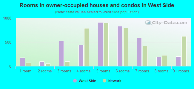
- Rooms in owner-occupied houses and condos in West Side
- 1,0971 room
- 1,0232 rooms
- 3083 rooms
- 6804 rooms
- 9545 rooms
- 6416 rooms
- 4837 rooms
- 7468 rooms
- 1,1269+ rooms
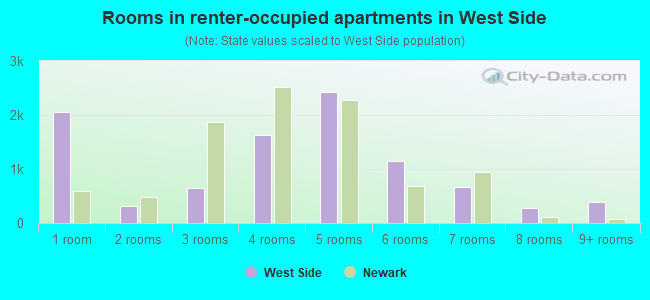
- Rooms in renter-occupied apartments in West Side
- 5931 room
- 622 rooms
- 1,5113 rooms
- 1,5714 rooms
- 1,4485 rooms
- 1,1166 rooms
- 3817 rooms
- 1,6568 rooms
- 3319+ rooms
Owner-occupied
Renter-occupied
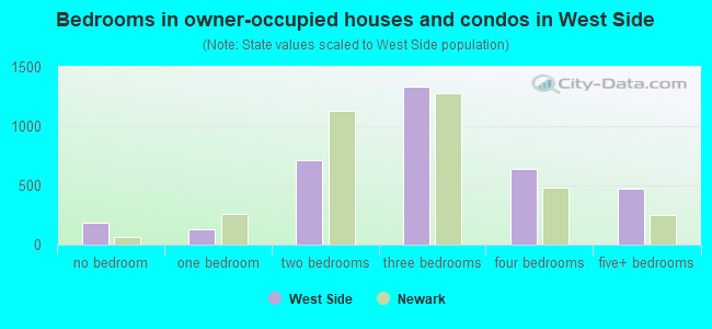
- Bedrooms in owner-occupied houses and condos in West Side
- 1,097no bedroom
- 2101 bedroom
- 1,1572 bedrooms
- 9373 bedrooms
- 2,3174 bedrooms
- 9105+ bedrooms
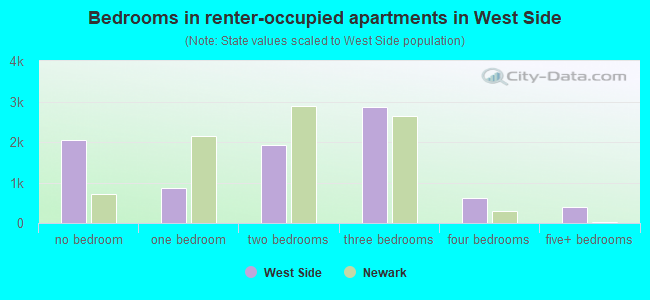
- Bedrooms in renter-occupied apartments in West Side
- 229no bedroom
- 1,5481 bedroom
- 1,8212 bedrooms
- 1,8263 bedrooms
- 2,6524 bedrooms
- 195+ bedrooms
Average number of cars or other vehicles available in houses/condos:
Average number of cars or other vehicles available in apartments:
| This neighborhood: | |
| Jersey City: |
Average number of cars or other vehicles available in apartments:
| Here: | |
| city: |
Percentage of units with a mortgage:
| West Side: | 65.4% |
| Jersey City: | 69.4% |
Average estimated value of housing units in 2-unit structures in 2022 (32.7% of all units):
| This neighborhood: | $403,208 |
| Jersey City: | $571,976 |
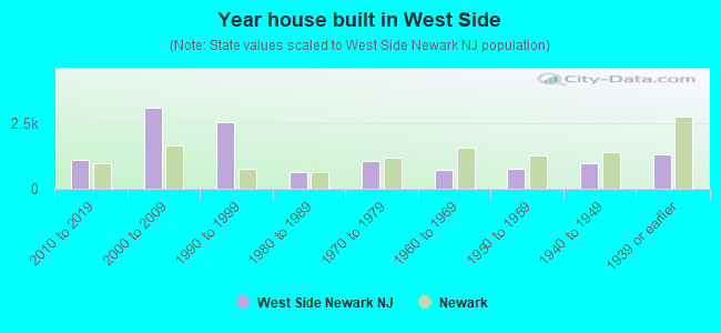
- Year house built in West Side
- 1,0732020 or later
- 1,7212010 to 2019
- 7252000 to 2009
- 9441990 to 1999
- 4081980 to 1989
- 8471970 to 1979
- 7731960 to 1969
- 2,7341950 to 1959
- 1,0041940 to 1949
- 3,5181939 or earlier
City-data.com crime index for city in 2020 (higher means more crime):
| City: | 198.8 |
| U.S. average: | 219.5 |
Travel time to work (commute)
![Travel time to work (commute)]()
- 76Less than 5 minutes
- 4875 to 9 minutes
- 1,40710 to 14 minutes
- 1,28415 to 19 minutes
- 1,10820 to 24 minutes
- 38225 to 29 minutes
- 1,69330 to 34 minutes
- 37435 to 39 minutes
- 53940 to 44 minutes
- 1,88045 to 59 minutes
- 2,38860 to 89 minutes
- 75390 or more minutes

Means of transportation to work
![Means of transportation to work]()
- 39.5%4,571Drove a car alone
- 9.8%1,133Carpooled
- 17.7%2,044Bus
- 10.6%1,221Subway or elevated rail
- 4.7%549Long-distance train or commuter rail
- 8.1%939Light rail, streetcar or trolley
- 17.2%1,991Taxi
- 3.4%394Bicycle
- 8.3%961Walked
- 8.8%1,018Other means
- 12.6%1,453Worked at home

Time leaving home to go to work
![Time leaving home to go to work]()
- 86412:00 a.m. to 4:59 a.m.
- 3215:00 a.m. to 5:29 a.m.
- 5265:30 a.m. to 5:59 a.m.
- 5736:00 a.m. to 6:29 a.m.
- 9296:30 a.m. to 6:59 a.m.
- 1,6297:00 a.m. to 7:29 a.m.
- 1,0997:30 a.m. to 7:59 a.m.
- 2,4418:00 a.m. to 8:29 a.m.
- 8808:30 a.m. to 8:59 a.m.
- 1,3439:00 a.m. to 9:59 a.m.
- 30810:00 a.m. to 10:59 a.m.
- 7511:00 a.m. to 11:59 a.m.
- 79612:00 p.m. to 3:59 p.m.
- 9504:00 p.m. to 11:59 p.m.

Occupations of males:
- Percentage of males in management occupations (except farmers):
Here: 3.5% city: 12.9%
- Percentage of males in business and financial operations occupations:
Here: 1.8% city: 9.9%
- Percentage of males in computer and mathematical occupations:
Here: 4.5% city: 13.5%
- Percentage of males in architecture and engineering occupations:
Here: 2.1% city: 3.7%
- Percentage of males in community and social services occupations:
Here: 1.2% city: 0.7%
- Percentage of males in education, training, and library occupations:
Here: 3.5% city: 3.6%
- Percentage of males in arts, design, entertainment, sports, and media occupations:
Here: 2.1% city: 3.5%
- Percentage of males in healthcare practitioners and technical occupations:
Here: 3.6% city: 2.6%
- Percentage of males in service occupations:
Here: 19.2% city: 10.4%
- Percentage of males in sales and office occupations:
Here: 21.1% city: 13.4%
- Percentage of males in construction, extraction, and maintenance occupations:
Here: 9.8% city: 5.6%
- Percentage of males in production occupations:
Here: 4.7% city: 2.8%
- Percentage of males in transportation occupations:
Here: 13.8% city: 7.2%
- Percentage of males in material moving occupations:
Here: 6.6% city: 4.2%
Occupations of females:
- Percentage of females in management occupations (except farmers):
Here: 5.6% city: 11.5%
- Percentage of females in business and financial operations occupations:
Here: 3.9% city: 11.7%
- Percentage of females in computer and mathematical occupations:
Here: 1.7% city: 5.3%
- Percentage of females in community and social services occupations:
Here: 4.5% city: 2.2%
- Percentage of females in education, training, and library occupations:
Here: 13.9% city: 8.3%
- Percentage of females in arts, design, entertainment, sports, and media occupations:
Here: 2.9% city: 4.9%
- Percentage of females in healthcare practitioners and technical occupations:
Here: 7.9% city: 6.5%
- Percentage of females in service occupations:
Here: 36.8% city: 17.9%
- Percentage of females in sales and office occupations:
Here: 19.7% city: 21.2%
- Percentage of females in production occupations:
Here: 1.6% city: 2.7%
Percentage of people 16-64 in Armed Forces:
| West Side: | 0.0% |
| Jersey City: | 0.1% |
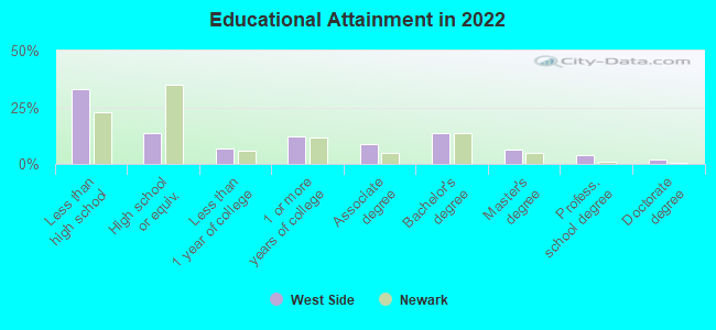
Education in this neighborhood (subdivision or community):
- Percentage of people 3 years and older in K-12 schools:
West Side: 44.8% Jersey City: 12.9%
- Percentage of people 3 years and older in undergraduate colleges:
West Side: 8.8% Jersey City: 4.5%
- Percentage of people 3 years and older in grad. or professional schools:
West Side: 5.2% Jersey City: 2.2%
- Percentage of students K-12 enrolled in private schools:
West Side: 47.0% Jersey City: 10.8%
Percentage of population below poverty level:
| West Side: | 22.0% |
| Jersey City: | 12.8% |
Percentage of married-couple families with both working:
| West Side: | 77.6% |
| Jersey City: | 63.9% |
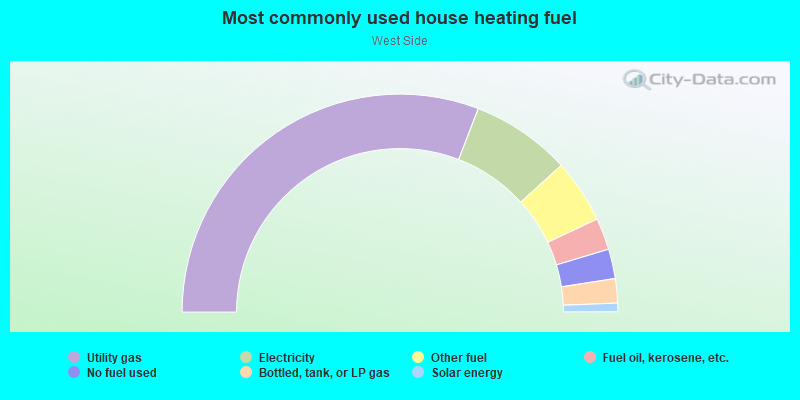
- 62.0%Utility gas
- 13.5%Electricity
- 5.7%No fuel used
- 5.2%Other fuel
- 4.5%Bottled, tank, or LP gas
- 4.2%Fuel oil, kerosene, etc.
- 3.0%Solar energy
- 1.9%Wood
Highways in this neighborhood:
US Hwy 9 (Pulaski Skwy, US Hwy 1)
Length: 2.03 miles
Direction: E-W
Direction: E-W
US Hwy 1 (Trk) (US Hwy 9 (Trk), State Rte 440)
Length: 1.33 miles
Directions: E-W, SW-NE
Directions: E-W, SW-NE
State Rte 501 (John F Kennedy Blvd)
Length: 1.15 miles
Directions: N-S, SW-NE
Address range: 2100 to 2523
Directions: N-S, SW-NE
Address range: 2100 to 2523
State Rte 7 (Newark Ave)
Length: 0.93 miles
Directions: E-W, SE-NW
Address range: 870 to 982
Directions: E-W, SE-NW
Address range: 870 to 982
Lincoln Hwy (US Hwy 9 (Trk), US Hwy 1 (Trk))
Length: 0.50 miles
Directions: E-W, SE-NW
Directions: E-W, SE-NW
State Rte 440
Length: 0.05 miles
Direction: SW-NE
Direction: SW-NE
Roads and streets:
Lincoln Park
Length: 2.13 miles
Directions: E-W, N-S, SE-NW, SW-NE
Directions: E-W, N-S, SE-NW, SW-NE
Co Rd 605 (W Side Ave)
Length: 1.37 miles
Direction: SW-NE
Address range: 475 to 989
Direction: SW-NE
Address range: 475 to 989
Duncan Ave
Length: 1.27 miles
Direction: SE-NW
Address range: 161 to 581
Direction: SE-NW
Address range: 161 to 581
Co Rd 612 (Communipaw Ave)
Length: 1.07 miles
Direction: E-W
Address range: 657 to 998
Direction: E-W
Address range: 657 to 998
Sip Ave
Length: 1.04 miles
Directions: E-W, SE-NW
Address range: 235 to 423
Directions: E-W, SE-NW
Address range: 235 to 423
Bergen Ave (Co Rd 607)
Length: 0.98 miles
Direction: SW-NE
Address range: 272 to 642
Direction: SW-NE
Address range: 272 to 642
Lexington Ave
Length: 0.94 miles
Direction: SE-NW
Address range: 1 to 321
Direction: SE-NW
Address range: 1 to 321
Clendenny Ave
Length: 0.92 miles
Direction: SE-NW
Address range: 1 to 310
Direction: SE-NW
Address range: 1 to 310
Mallory Ave (Co Rd 611)
Length: 0.75 miles
Directions: SE-NW, SW-NE
Address range: 146 to 487
Directions: SE-NW, SW-NE
Address range: 146 to 487
St Pauls Ave (Co Rd 646, Saint Pauls Ave)
Length: 0.67 miles
Direction: E-W
Address range: 305 to 519
Direction: E-W
Address range: 305 to 519
Union St
Length: 0.66 miles
Direction: SE-NW
Address range: 216 to 438
Direction: SE-NW
Address range: 216 to 438
Kensington Ave
Length: 0.61 miles
Direction: SE-NW
Address range: 7 to 158
Direction: SE-NW
Address range: 7 to 158
Roosevelt Ave
Length: 0.56 miles
Direction: SE-NW
Address range: 1 to 206
Direction: SE-NW
Address range: 1 to 206
Broadway Way
Length: 0.55 miles
Direction: E-W
Direction: E-W
Clinton Ave
Length: 0.53 miles
Direction: SE-NW
Address range: 89 to 279
Direction: SE-NW
Address range: 89 to 279
Logan Ave
Length: 0.47 miles
Direction: E-W
Address range: 1 to 199
Direction: E-W
Address range: 1 to 199
Jewett Ave
Length: 0.47 miles
Direction: SE-NW
Address range: 113 to 279
Direction: SE-NW
Address range: 113 to 279
Williams Ave
Length: 0.47 miles
Direction: SE-NW
Address range: 1 to 153
Direction: SE-NW
Address range: 1 to 153
Oxford Ave
Length: 0.46 miles
Direction: SE-NW
Address range: 1 to 168
Direction: SE-NW
Address range: 1 to 168
Gifford Ave
Length: 0.46 miles
Direction: SE-NW
Address range: 1 to 162
Direction: SE-NW
Address range: 1 to 162
Bentley Ave
Length: 0.46 miles
Direction: SE-NW
Address range: 1 to 162
Direction: SE-NW
Address range: 1 to 162
Harrison Ave
Length: 0.45 miles
Direction: SE-NW
Address range: 133 to 306
Direction: SE-NW
Address range: 133 to 306
Duffield Ave
Length: 0.43 miles
Directions: E-W, SW-NE
Address range: 1 to 160
Directions: E-W, SW-NE
Address range: 1 to 160
James Ave
Length: 0.41 miles
Directions: N-S, SW-NE
Address range: 1 to 130
Directions: N-S, SW-NE
Address range: 1 to 130
Co Rd 643 (Van Keuren Ave)
Length: 0.41 miles
Directions: E-W, SE-NW, SW-NE
Address range: 1 to 160
Directions: E-W, SE-NW, SW-NE
Address range: 1 to 160
Delaware Ave
Length: 0.37 miles
Direction: SW-NE
Address range: 1 to 237
Direction: SW-NE
Address range: 1 to 237
Belmont Ave
Length: 0.37 miles
Direction: SE-NW
Address range: 131 to 227
Direction: SE-NW
Address range: 131 to 227
Wallis Ave
Length: 0.35 miles
Directions: E-W, N-S, SW-NE
Address range: 1 to 130
Directions: E-W, N-S, SW-NE
Address range: 1 to 130
Co Rd 608 (Claremont Ave)
Length: 0.34 miles
Direction: SE-NW
Address range: 228 to 342
Direction: SE-NW
Address range: 228 to 342
Orient Ave
Length: 0.32 miles
Direction: SE-NW
Address range: 148 to 299
Direction: SE-NW
Address range: 148 to 299
Howell Ave
Length: 0.32 miles
Direction: E-W
Address range: 103 to 150
Direction: E-W
Address range: 103 to 150
Gautier Ave
Length: 0.31 miles
Direction: SE-NW
Address range: 1 to 99
Direction: SE-NW
Address range: 1 to 99
Broadman Pkwy
Length: 0.29 miles
Direction: SE-NW
Address range: 1 to 98
Direction: SE-NW
Address range: 1 to 98
Broadway
Length: 0.29 miles
Directions: E-W, SE-NW
Address range: 93 to 399
Directions: E-W, SE-NW
Address range: 93 to 399
Dey St
Length: 0.29 miles
Direction: E-W
Address range: 26 to 240
Direction: E-W
Address range: 26 to 240
Howell St
Length: 0.29 miles
Direction: E-W
Address range: 1 to 200
Direction: E-W
Address range: 1 to 200
Belvidere Ave
Length: 0.28 miles
Direction: SW-NE
Address range: 1 to 298
Direction: SW-NE
Address range: 1 to 298
Wales Ave
Length: 0.27 miles
Direction: SW-NE
Address range: 1 to 130
Direction: SW-NE
Address range: 1 to 130
Giles Ave
Length: 0.27 miles
Direction: SW-NE
Address range: 1 to 128
Direction: SW-NE
Address range: 1 to 128
Condict St
Length: 0.25 miles
Direction: SE-NW
Address range: 1 to 99
Direction: SE-NW
Address range: 1 to 99
Westside Ave
Length: 0.24 miles
Direction: SW-NE
Address range: 1172 to 1292
Direction: SW-NE
Address range: 1172 to 1292
Dales Ave
Length: 0.22 miles
Direction: SW-NE
Address range: 1 to 100
Direction: SW-NE
Address range: 1 to 100
Freeman Ave
Length: 0.22 miles
Directions: N-S, SW-NE
Address range: 179 to 413
Directions: N-S, SW-NE
Address range: 179 to 413
Boyd Ave
Length: 0.22 miles
Direction: SE-NW
Address range: 37 to 117
Direction: SE-NW
Address range: 37 to 117
Wright Ave
Length: 0.22 miles
Direction: SW-NE
Address range: 1 to 99
Direction: SW-NE
Address range: 1 to 99
Van Winkle Ave
Length: 0.21 miles
Direction: E-W
Address range: 281 to 335
Direction: E-W
Address range: 281 to 335
Van Wagenen Ave
Length: 0.21 miles
Direction: SW-NE
Address range: 1 to 280
Direction: SW-NE
Address range: 1 to 280
Meadow St
Length: 0.21 miles
Direction: E-W
Address range: 1 to 81
Direction: E-W
Address range: 1 to 81
Virginia Ave
Length: 0.21 miles
Direction: SE-NW
Address range: 136 to 199
Direction: SE-NW
Address range: 136 to 199
Nunda Ave
Length: 0.20 miles
Direction: SW-NE
Address range: 1 to 299
Direction: SW-NE
Address range: 1 to 299
Olean Ave
Length: 0.20 miles
Direction: SW-NE
Address range: 1 to 299
Direction: SW-NE
Address range: 1 to 299
Tonnelle Ave
Length: 0.19 miles
Directions: SE-NW, SW-NE
Address range: 184 to 269
Directions: SE-NW, SW-NE
Address range: 184 to 269
Marcy Ave
Length: 0.19 miles
Directions: E-W, SW-NE
Address range: 1 to 67
Directions: E-W, SW-NE
Address range: 1 to 67
Lewis Ave
Length: 0.15 miles
Direction: SW-NE
Address range: 1 to 57
Direction: SW-NE
Address range: 1 to 57
Tyson Ln
Length: 0.15 miles
Directions: SE-NW, SW-NE
Address range: 1 to 99
Directions: SE-NW, SW-NE
Address range: 1 to 99
Stockton Ave
Length: 0.14 miles
Directions: E-W, SW-NE
Address range: 193 to 245
Directions: E-W, SW-NE
Address range: 193 to 245
Bryant Ave
Length: 0.13 miles
Direction: SW-NE
Address range: 1 to 52
Direction: SW-NE
Address range: 1 to 52
Larch Ave
Length: 0.13 miles
Directions: E-W, SW-NE
Address range: 63 to 100
Directions: E-W, SW-NE
Address range: 63 to 100
Corbin Ave
Length: 0.13 miles
Direction: SW-NE
Address range: 1 to 50
Direction: SW-NE
Address range: 1 to 50
Senate Pl
Length: 0.13 miles
Direction: SW-NE
Address range: 1 to 54
Direction: SW-NE
Address range: 1 to 54
Co Rd 645 (Charlotte Ave)
Length: 0.13 miles
Direction: SW-NE
Address range: 1 to 68
Direction: SW-NE
Address range: 1 to 68
Fairview Ave
Length: 0.13 miles
Direction: SE-NW
Address range: 179 to 225
Direction: SE-NW
Address range: 179 to 225
Stuyvesant Ave
Length: 0.13 miles
Directions: E-W, SE-NW
Address range: 74 to 127
Directions: E-W, SE-NW
Address range: 74 to 127
Plainfield Ave
Length: 0.12 miles
Direction: SW-NE
Address range: 100 to 299
Direction: SW-NE
Address range: 100 to 299
Morton Pl
Length: 0.12 miles
Direction: SE-NW
Address range: 1 to 55
Direction: SE-NW
Address range: 1 to 55
Ege Ave
Length: 0.12 miles
Direction: SE-NW
Address range: 119 to 162
Direction: SE-NW
Address range: 119 to 162
Emerson Ave
Length: 0.11 miles
Direction: SW-NE
Address range: 1 to 41
Direction: SW-NE
Address range: 1 to 41
Whitman Ave
Length: 0.10 miles
Direction: SW-NE
Address range: 1 to 55
Direction: SW-NE
Address range: 1 to 55
Hawthorne Ave
Length: 0.09 miles
Direction: SW-NE
Address range: 1 to 46
Direction: SW-NE
Address range: 1 to 46
Miller St
Length: 0.09 miles
Direction: SW-NE
Address range: 1 to 99
Direction: SW-NE
Address range: 1 to 99
Everett St
Length: 0.08 miles
Direction: SW-NE
Address range: 1 to 74
Direction: SW-NE
Address range: 1 to 74
Morton St
Length: 0.08 miles
Direction: SW-NE
Address range: 1 to 36
Direction: SW-NE
Address range: 1 to 36
Covert St (Covert Ave)
Length: 0.07 miles
Direction: SW-NE
Direction: SW-NE
Fayette Pl
Length: 0.07 miles
Direction: E-W
Address range: 23 to 35
Direction: E-W
Address range: 23 to 35
Holmes Ave
Length: 0.07 miles
Direction: SW-NE
Address range: 1 to 36
Direction: SW-NE
Address range: 1 to 36
Halstead St
Length: 0.06 miles
Directions: SE-NW, SW-NE
Address range: 1 to 99
Directions: SE-NW, SW-NE
Address range: 1 to 99
Virginia Ter
Length: 0.06 miles
Direction: SW-NE
Address range: 1 to 36
Direction: SW-NE
Address range: 1 to 36
Halleck Ave
Length: 0.06 miles
Direction: N-S
Address range: 1 to 133
Direction: N-S
Address range: 1 to 133
Amelia Ave
Length: 0.06 miles
Direction: SE-NW
Address range: 1 to 13
Direction: SE-NW
Address range: 1 to 13
Sackett St
Length: 0.05 miles
Direction: SW-NE
Address range: 69 to 90
Direction: SW-NE
Address range: 69 to 90
Charlotte Cir
Length: 0.05 miles
Directions: E-W, N-S, SE-NW, SW-NE
Directions: E-W, N-S, SE-NW, SW-NE
Boyd Ct
Length: 0.04 miles
Direction: SW-NE
Address range: 1 to 15
Direction: SW-NE
Address range: 1 to 15
Sterling Ave
Length: 0.04 miles
Direction: SW-NE
Direction: SW-NE
Co Rd 646
Length: 0.03 miles
Direction: E-W
Direction: E-W
Railroad features:
Norfolk Southern Rlwy
Length: 1.30 miles
Directions: E-W, N-S, SE-NW, SW-NE
Directions: E-W, N-S, SE-NW, SW-NE
Conrail RR (Csx RR & Norfolk Southern Rlwy)
Length: 1.16 miles
Directions: E-W, N-S, SE-NW
Directions: E-W, N-S, SE-NW
Penn Central RR (Csx RR & Norfolk Southern Rlwy)
Length: 0.44 miles
Directions: E-W, SE-NW
Directions: E-W, SE-NW
Central Railroad of New Jersey
Length: 0.16 miles
Direction: E-W
Direction: E-W