Yorkmount neighborhood in Charlotte, North Carolina (NC), 28217, 28273 detailed profile
Settings
X


Business Search - 14 Million verified businesses
Area: 4.256 square miles
Population: 6,521
Population density:
| Yorkmount: | 1,532 people per square mile |
| Charlotte: | 3,705 people per square mile |

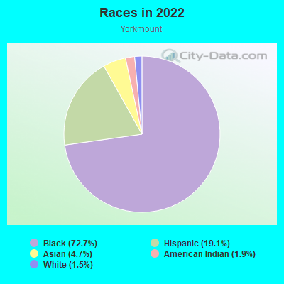
- 4,73972.7%Black
- 1,24719.1%Hispanic or Latino
- 3094.7%Asian
- 1271.9%American Indian
- 971.5%White
Median household income in 2022:
| Yorkmount: | $27,539 |
| Charlotte: | $74,401 |
Distribution of median household income
![Distribution of median household income]()
- 442Less than $10,000
- 866$10,000 to $19,999
- 501$20,000 to $29,999
- 425$30,000 to $39,999
- 412$40,000 to $49,999
- 174$50,000 to $59,999
- 141$60,000 to $74,999
- 111$75,000 to $99,999
- 43$100,000 to $124,999
- 136$150,000 to $199,999
- 102$200,000 or more

Distribution of owner-occupied house/condo value
![Distribution of owner-occupied house/condo value]()
- 60Less than $50,000
- 421$50,000 to $99,999
- 269$100,000 to $149,999
- 96$150,000 to $199,999
- 30$200,000 to $249,999
- 51$250,000 to $299,999
- 153$300,000 to $399,999
- 40$400,000 to $499,999
- 88$500,000 to $749,999
- 88$1,000,000 or more

Distribution of rent paid by renters
![Distribution of rent paid by renters]()
- 391$100 to $199
- 259$200 to $299
- 95$300 to $399
- 145$400 to $499
- 183$600 to $699
- 183$700 to $799
- 455$800 to $899
- 327$900 to $999
- 387$1,000 to $1,249
- 115$1,250 to $1,499
- 222$1,500 to $1,999
- 42$2,000 or more

Median rent in 2022:
| Yorkmount: | $814 |
| Charlotte: | $1,334 |
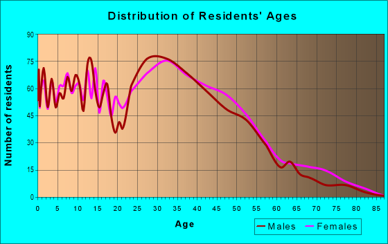
| Males: | 3,657 |
| Females: | 2,864 |
Males:
| This neighborhood: | 33.0 years |
| Whole city: | 33.8 years |
| This neighborhood: | 55.2 years |
| Whole city: | 35.3 years |
Average household size:
| Yorkmount: | 1.9 people |
| Charlotte: | 2.3 people |
Percentage of family households:
| Yorkmount: | 39.8% |
| Charlotte: | 42.8% |
| Here: | 23.2% |
| Charlotte: | 36.9% |
Percentage of married-couple families with children (among all households):
| Yorkmount: | 27.9% |
| Charlotte: | 27.1% |
Percentage of single-mother households (among all households):
| Yorkmount: | 23.4% |
| Charlotte: | 11.0% |
Percentage of never married males 15 years old and over:
Percentage of never married females 15 years old and over:
| Yorkmount: | 24.7% |
| Charlotte: | 21.6% |
Percentage of never married females 15 years old and over:
| Yorkmount: | 17.7% |
| city: | 22.1% |
Percentage of people that speak English not well or not at all:
| Yorkmount: | 9.1% |
| Charlotte: | 5.7% |
Percentage of people born in this state:
Percentage of people born in another U.S. state:
Percentage of native residents but born outside the U.S.:
Percentage of foreign born residents:
| Here: | 54.7% |
| Charlotte: | 40.1% |
Percentage of people born in another U.S. state:
| Yorkmount: | 35.5% |
| Charlotte: | 41.5% |
Percentage of native residents but born outside the U.S.:
| Here: | 0.9% |
| city: | 1.5% |
Percentage of foreign born residents:
| Here: | 9.0% |
| Charlotte: | 16.8% |
Owner-occupied
Renter-occupied

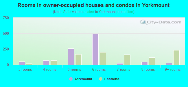
- Rooms in owner-occupied houses and condos in Yorkmount
- 01 room
- 02 rooms
- 503 rooms
- 694 rooms
- 2585 rooms
- 4966 rooms
- 257 rooms
- 468 rooms
- 299+ rooms
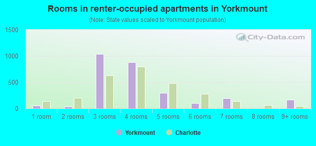
- Rooms in renter-occupied apartments in Yorkmount
- 551 room
- 362 rooms
- 1,0393 rooms
- 8824 rooms
- 2975 rooms
- 996 rooms
- 1987 rooms
- 08 rooms
- 1659+ rooms
Owner-occupied
Renter-occupied
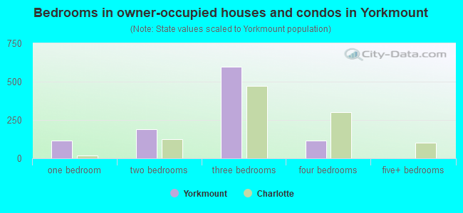
- Bedrooms in owner-occupied houses and condos in Yorkmount
- 0no bedroom
- 1181 bedroom
- 1902 bedrooms
- 5983 bedrooms
- 1154 bedrooms
- 05+ bedrooms
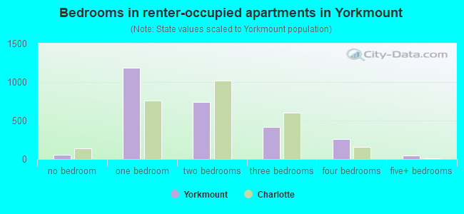
- Bedrooms in renter-occupied apartments in Yorkmount
- 55no bedroom
- 1,1831 bedroom
- 7382 bedrooms
- 4203 bedrooms
- 2614 bedrooms
- 425+ bedrooms
Average number of cars or other vehicles available in houses/condos:
Average number of cars or other vehicles available in apartments:
| This neighborhood: | 2.7 |
| Charlotte: | 2.0 |
Average number of cars or other vehicles available in apartments:
| Here: | 0.9 |
| city: | 1.4 |
Percentage of units with a mortgage:
| Yorkmount: | 46.3% |
| Charlotte: | 74.9% |
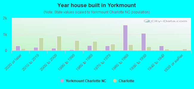
- Year house built in Yorkmount
- 2862020 or later
- 2072010 to 2019
- 1442000 to 2009
- 551990 to 1999
- 3091980 to 1989
- 2921970 to 1979
- 1,5861960 to 1969
- 1,0651950 to 1959
- 2921940 to 1949
- 01939 or earlier
Travel time to work (commute)
![Travel time to work (commute)]()
- 140Less than 5 minutes
- 3305 to 9 minutes
- 63710 to 14 minutes
- 45515 to 19 minutes
- 68120 to 24 minutes
- 16625 to 29 minutes
- 13630 to 34 minutes
- 3935 to 39 minutes
- 6940 to 44 minutes
- 11545 to 59 minutes
- 5590 or more minutes

Means of transportation to work
![Means of transportation to work]()
- 67.5%1,794Drove a car alone
- 17.2%458Carpooled
- 4.8%127Bus
- 6.4%169Walked
- 4.0%106Worked at home

Time leaving home to go to work
![Time leaving home to go to work]()
- 10612:00 a.m. to 4:59 a.m.
- 1895:00 a.m. to 5:29 a.m.
- 1335:30 a.m. to 5:59 a.m.
- 626:00 a.m. to 6:29 a.m.
- 1086:30 a.m. to 6:59 a.m.
- 6907:00 a.m. to 7:29 a.m.
- 3097:30 a.m. to 7:59 a.m.
- 2378:00 a.m. to 8:29 a.m.
- 1038:30 a.m. to 8:59 a.m.
- 839:00 a.m. to 9:59 a.m.
- 11310:00 a.m. to 10:59 a.m.
- 7111:00 a.m. to 11:59 a.m.
- 47112:00 p.m. to 3:59 p.m.
- 1454:00 p.m. to 11:59 p.m.

Occupations of males:
- Percentage of males in management occupations (except farmers):
Here: 20.7% city: 15.2%
- Percentage of males in business and financial operations occupations:
Here: 9.2% city: 8.5%
- Percentage of males in computer and mathematical occupations:
Here: 16.1% city: 7.7%
- Percentage of males in architecture and engineering occupations:
Here: 4.3% city: 3.2%
- Percentage of males in legal occupations:
Here: 2.5% city: 1.4%
- Percentage of males in service occupations:
Here: 11.5% city: 11.0%
- Percentage of males in sales and office occupations:
Here: 23.6% city: 16.3%
- Percentage of males in construction, extraction, and maintenance occupations:
Here: 8.2% city: 8.9%
- Percentage of males in transportation occupations:
Here: 2.0% city: 5.6%
- Percentage of males in material moving occupations:
Here: 16.7% city: 5.7%
Occupations of females:
- Percentage of females in management occupations (except farmers):
Here: 12.1% city: 11.3%
- Percentage of females in business and financial operations occupations:
Here: 1.8% city: 10.5%
- Percentage of females in life, physical, and social science occupations:
Here: 1.3% city: 0.7%
- Percentage of females in healthcare practitioners and technical occupations:
Here: 7.3% city: 7.2%
- Percentage of females in service occupations:
Here: 48.0% city: 17.4%
- Percentage of females in sales and office occupations:
Here: 16.9% city: 26.2%
- Percentage of females in construction, extraction, and maintenance occupations:
Here: 4.0% city: 0.8%
- Percentage of females in production occupations:
Here: 7.3% city: 2.9%
- Percentage of females in material moving occupations:
Here: 13.9% city: 2.8%
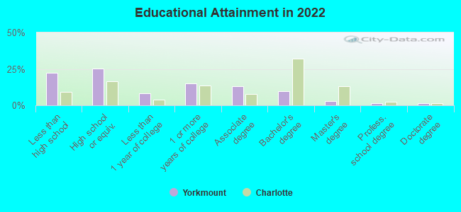
Education in this neighborhood (subdivision or community):
- Percentage of people 3 years and older in K-12 schools:
Yorkmount: 26.6% Charlotte: 16.6%
- Percentage of people 3 years and older in undergraduate colleges:
Yorkmount: 2.2% Charlotte: 5.0%
- Percentage of people 3 years and older in grad. or professional schools:
Yorkmount: 0.0% Charlotte: 1.5%
- Percentage of students K-12 enrolled in private schools:
Yorkmount: 0.1% Charlotte: 10.1%
Percentage of population below poverty level:
| Yorkmount: | 14.7% |
| Charlotte: | 11.8% |
Median year owner moved in (as recorded in 2022):
Median year renter moved in (as recorded in 2022):
| Yorkmount: | 1996 |
| Charlotte: | 2012 |
Median year renter moved in (as recorded in 2022):
| Yorkmount: | 2013 |
| Charlotte: | 2020 |
Percentage of married-couple families with both working:
| Yorkmount: | 63.0% |
| Charlotte: | 66.4% |
- 66.6%Electricity
- 31.6%Utility gas
- 1.0%Bottled, tank, or LP gas
- 0.8%No fuel used
Limited-access highways (interstate or state) in this neighborhood:
US Hwy 21 (I- 77)
Length: 2.62 miles
Direction: SW-NE
Direction: SW-NE
I- 485 (Seddon Rusty Goode Fwy)
Length: 1.23 miles
Direction: SE-NW
Direction: SE-NW
Highways in this neighborhood:
State Hwy 49 (S Tryon St)
Length: 1.01 miles
Direction: SW-NE
Address range: 4800 to 8117
Direction: SW-NE
Address range: 4800 to 8117
Roads and streets:
State Rd 1164 (Nations Ford Rd)
Length: 2.22 miles
Directions: N-S, SE-NW, SW-NE
Address range: 5100 to 7699
Directions: N-S, SE-NW, SW-NE
Address range: 5100 to 7699
State Rd 1138 (W Arrowood Rd)
Length: 1.28 miles
Direction: SE-NW
Address range: 1100 to 2199
Direction: SE-NW
Address range: 1100 to 2199
State Rd 1163 (Choyce Ave)
Length: 0.98 miles
Directions: E-W, SW-NE
Address range: 1000 to 1799
Directions: E-W, SW-NE
Address range: 1000 to 1799
Red Oak Blvd
Length: 0.93 miles
Directions: E-W, N-S, SE-NW, SW-NE
Address range: 8700 to 8999
Directions: E-W, N-S, SE-NW, SW-NE
Address range: 8700 to 8999
Edgegreen Dr
Length: 0.89 miles
Directions: E-W, SE-NW
Address range: 200 to 1099
Directions: E-W, SE-NW
Address range: 200 to 1099
Echodale Dr
Length: 0.87 miles
Directions: E-W, N-S, SE-NW
Address range: 100 to 899
Directions: E-W, N-S, SE-NW
Address range: 100 to 899
W Tyvola Rd
Length: 0.84 miles
Directions: E-W, N-S, SE-NW
Address range: 102 to 110
Directions: E-W, N-S, SE-NW
Address range: 102 to 110
Sharview Cir
Length: 0.77 miles
Directions: E-W, N-S, SE-NW, SW-NE
Address range: 300 to 1199
Directions: E-W, N-S, SE-NW, SW-NE
Address range: 300 to 1199
Southern Pine Blvd
Length: 0.73 miles
Directions: N-S, SW-NE
Address range: 9000 to 9899
Directions: N-S, SW-NE
Address range: 9000 to 9899
Ranchwood Dr
Length: 0.64 miles
Directions: E-W, N-S, SE-NW, SW-NE
Address range: 1500 to 2099
Directions: E-W, N-S, SE-NW, SW-NE
Address range: 1500 to 2099
Bramblewood Rd
Length: 0.62 miles
Directions: E-W, N-S, SW-NE
Address range: 7200 to 7999
Directions: E-W, N-S, SW-NE
Address range: 7200 to 7999
State Rd 1171 (Wilbrown Cir)
Length: 0.62 miles
Directions: E-W, N-S, SE-NW, SW-NE
Address range: 400 to 999
Directions: E-W, N-S, SE-NW, SW-NE
Address range: 400 to 999
Southampton Rd (State Rd 1326)
Length: 0.61 miles
Directions: E-W, N-S, SE-NW, SW-NE
Address range: 5300 to 5799
Directions: E-W, N-S, SE-NW, SW-NE
Address range: 5300 to 5799
Tyvola Centre Dr
Length: 0.59 miles
Directions: E-W, SE-NW, SW-NE
Address range: 5700 to 6259
Directions: E-W, SE-NW, SW-NE
Address range: 5700 to 6259
State Rd 1340 (Sleepy Hollow Rd)
Length: 0.59 miles
Directions: E-W, SE-NW
Address range: 100 to 699
Directions: E-W, SE-NW
Address range: 100 to 699
Yorkdale Dr
Length: 0.56 miles
Directions: E-W, SE-NW, SW-NE
Address range: 700 to 1299
Directions: E-W, SE-NW, SW-NE
Address range: 700 to 1299
Hanson Rd
Length: 0.54 miles
Directions: E-W, N-S, SE-NW, SW-NE
Address range: 1801 to 1899
Directions: E-W, N-S, SE-NW, SW-NE
Address range: 1801 to 1899
State Rd 1158 (Choyce Cir)
Length: 0.52 miles
Directions: E-W, N-S, SE-NW, SW-NE
Address range: 1800 to 2099
Directions: E-W, N-S, SE-NW, SW-NE
Address range: 1800 to 2099
Yager Creek Dr
Length: 0.49 miles
Directions: E-W, N-S, SE-NW, SW-NE
Address range: 2100 to 2220
Directions: E-W, N-S, SE-NW, SW-NE
Address range: 2100 to 2220
Arrowpoint Blvd
Length: 0.49 miles
Directions: E-W, N-S, SW-NE
Address range: 9000 to 9499
Directions: E-W, N-S, SW-NE
Address range: 9000 to 9499
Queen Anne Rd (State Rd 1324)
Length: 0.49 miles
Directions: E-W, SW-NE
Address range: 5100 to 5499
Directions: E-W, SW-NE
Address range: 5100 to 5499
Allegiance Dr
Length: 0.46 miles
Directions: E-W, SW-NE
Address range: 1006 to 1349
Directions: E-W, SW-NE
Address range: 1006 to 1349
Peachtree Dr
Length: 0.41 miles
Directions: E-W, N-S, SE-NW, SW-NE
Address range: 100 to 599
Directions: E-W, N-S, SE-NW, SW-NE
Address range: 100 to 599
Cormwell Ln
Length: 0.41 miles
Directions: N-S, SW-NE
Address range: 7200 to 7499
Directions: N-S, SW-NE
Address range: 7200 to 7499
Regency Executive Pkwy
Length: 0.40 miles
Directions: E-W, N-S, SE-NW, SW-NE
Address range: 6600 to 6899
Directions: E-W, N-S, SE-NW, SW-NE
Address range: 6600 to 6899
Artwood Ln
Length: 0.36 miles
Direction: SE-NW
Address range: 1900 to 2299
Direction: SE-NW
Address range: 1900 to 2299
Mounting Rock Rd
Length: 0.35 miles
Directions: E-W, N-S, SE-NW
Address range: 6400 to 6799
Directions: E-W, N-S, SE-NW
Address range: 6400 to 6799
Gretna Green Dr
Length: 0.35 miles
Directions: E-W, SE-NW
Address range: 800 to 1199
Directions: E-W, SE-NW
Address range: 800 to 1199
Shadowcrest Dr
Length: 0.35 miles
Directions: E-W, SE-NW, SW-NE
Address range: 7400 to 7699
Directions: E-W, SE-NW, SW-NE
Address range: 7400 to 7699
Tyvola Rd
Length: 0.35 miles
Directions: E-W, N-S, SE-NW
Directions: E-W, N-S, SE-NW
State Rd 1339 (Coulee Pl)
Length: 0.34 miles
Directions: E-W, N-S, SE-NW, SW-NE
Address range: 5600 to 5799
Directions: E-W, N-S, SE-NW, SW-NE
Address range: 5600 to 5799
Oldfield Rd (Southern Pine Blvd)
Length: 0.34 miles
Directions: E-W, SW-NE
Directions: E-W, SW-NE
Woodknoll Dr
Length: 0.33 miles
Directions: N-S, SE-NW, SW-NE
Address range: 7500 to 7799
Directions: N-S, SE-NW, SW-NE
Address range: 7500 to 7799
Glenrock Dr
Length: 0.33 miles
Directions: E-W, N-S, SE-NW
Address range: 100 to 499
Directions: E-W, N-S, SE-NW
Address range: 100 to 499
Nations Dr (State Rd 1161)
Length: 0.33 miles
Directions: E-W, N-S, SW-NE
Address range: 1000 to 1199
Directions: E-W, N-S, SW-NE
Address range: 1000 to 1199
Doughton Ln
Length: 0.33 miles
Directions: E-W, SE-NW, SW-NE
Address range: 200 to 599
Directions: E-W, SE-NW, SW-NE
Address range: 200 to 599
Lady Liberty Ln
Length: 0.32 miles
Directions: E-W, N-S, SE-NW, SW-NE
Address range: 7400 to 7649
Directions: E-W, N-S, SE-NW, SW-NE
Address range: 7400 to 7649
Shady Grove Ln (State Rd 1327)
Length: 0.32 miles
Directions: E-W, N-S, SW-NE
Address range: 5100 to 5299
Directions: E-W, N-S, SW-NE
Address range: 5100 to 5299
Microsoft Way
Length: 0.32 miles
Directions: E-W, N-S, SW-NE
Address range: 8000 to 8099
Directions: E-W, N-S, SW-NE
Address range: 8000 to 8099
Ann Marie Dr
Length: 0.31 miles
Directions: E-W, N-S, SW-NE
Address range: 100 to 1299
Directions: E-W, N-S, SW-NE
Address range: 100 to 1299
Land Grant Rd
Length: 0.30 miles
Directions: E-W, N-S, SE-NW
Address range: 1000 to 1299
Directions: E-W, N-S, SE-NW
Address range: 1000 to 1299
Sharview Creek
Length: 0.30 miles
Directions: E-W, N-S, SE-NW, SW-NE
Address range: 808 to 1115
Directions: E-W, N-S, SE-NW, SW-NE
Address range: 808 to 1115
Holliswood Ct
Length: 0.29 miles
Directions: E-W, N-S, SE-NW, SW-NE
Address range: 7600 to 7899
Directions: E-W, N-S, SE-NW, SW-NE
Address range: 7600 to 7899
Tomlin Way Ct
Length: 0.29 miles
Directions: E-W, SE-NW
Address range: 8000 to 8273
Directions: E-W, SE-NW
Address range: 8000 to 8273
Marshall Air Dr (State Rd 1164)
Length: 0.29 miles
Directions: E-W, SW-NE
Address range: 5300 to 5599
Directions: E-W, SW-NE
Address range: 5300 to 5599
Sheryl Cir (State Rd 1160)
Length: 0.29 miles
Directions: E-W, N-S, SE-NW, SW-NE
Address range: 600 to 799
Directions: E-W, N-S, SE-NW, SW-NE
Address range: 600 to 799
Flodden Field Ct
Length: 0.28 miles
Directions: N-S, SE-NW
Address range: 7200 to 7499
Directions: N-S, SE-NW
Address range: 7200 to 7499
Westham Ridge Rd (State Rd 1376)
Length: 0.28 miles
Directions: E-W, SE-NW
Address range: 200 to 599
Directions: E-W, SE-NW
Address range: 200 to 599
Royal Point Dr
Length: 0.28 miles
Directions: E-W, N-S, SE-NW, SW-NE
Address range: 7800 to 7899
Directions: E-W, N-S, SE-NW, SW-NE
Address range: 7800 to 7899
Greenwood Dr
Length: 0.28 miles
Directions: E-W, SE-NW
Address range: 400 to 699
Directions: E-W, SE-NW
Address range: 400 to 699
Oak Crest Green Dr
Length: 0.27 miles
Directions: E-W, N-S, SE-NW, SW-NE
Address range: 5600 to 5731
Directions: E-W, N-S, SE-NW, SW-NE
Address range: 5600 to 5731
McDowell Farms Dr
Length: 0.27 miles
Directions: E-W, SE-NW
Address range: 1100 to 1344
Directions: E-W, SE-NW
Address range: 1100 to 1344
State Rd 1374 (Whispering Pines Dr)
Length: 0.27 miles
Directions: E-W, N-S, SE-NW, SW-NE
Address range: 300 to 499
Directions: E-W, N-S, SE-NW, SW-NE
Address range: 300 to 499
Dunbrook Ln
Length: 0.25 miles
Directions: E-W, N-S, SW-NE
Address range: 600 to 799
Directions: E-W, N-S, SW-NE
Address range: 600 to 799
Granby Cir
Length: 0.25 miles
Directions: E-W, N-S, SE-NW, SW-NE
Address range: 400 to 699
Directions: E-W, N-S, SE-NW, SW-NE
Address range: 400 to 699
Yorkhills Dr
Length: 0.25 miles
Directions: E-W, N-S, SE-NW, SW-NE
Directions: E-W, N-S, SE-NW, SW-NE
State Rd 1329 (Grapevine Dr)
Length: 0.24 miles
Directions: E-W, SW-NE
Address range: 5000 to 5199
Directions: E-W, SW-NE
Address range: 5000 to 5199
Old Towne Ct
Length: 0.24 miles
Direction: E-W
Address range: 1600 to 1999
Direction: E-W
Address range: 1600 to 1999
Regency Executive Pa Dr
Length: 0.24 miles
Direction: E-W
Address range: 100 to 299
Direction: E-W
Address range: 100 to 299
Longdale Dr
Length: 0.24 miles
Direction: E-W
Address range: 2000 to 2299
Direction: E-W
Address range: 2000 to 2299
Bangor Rd
Length: 0.23 miles
Directions: E-W, SE-NW
Address range: 1900 to 2199
Directions: E-W, SE-NW
Address range: 1900 to 2199
Franklin Springs Cir
Length: 0.23 miles
Directions: E-W, N-S, SE-NW, SW-NE
Address range: 5400 to 5699
Directions: E-W, N-S, SE-NW, SW-NE
Address range: 5400 to 5699
Skycrest Ln
Length: 0.22 miles
Directions: N-S, SW-NE
Address range: 6200 to 6599
Directions: N-S, SW-NE
Address range: 6200 to 6599
Rollingbrook Dr
Length: 0.22 miles
Directions: E-W, N-S, SE-NW, SW-NE
Address range: 400 to 520
Directions: E-W, N-S, SE-NW, SW-NE
Address range: 400 to 520
Diamond Creek Cir
Length: 0.22 miles
Directions: E-W, N-S, SE-NW, SW-NE
Address range: 2100 to 2219
Directions: E-W, N-S, SE-NW, SW-NE
Address range: 2100 to 2219
Cameron Walk Ct
Length: 0.22 miles
Directions: E-W, N-S, SE-NW, SW-NE
Address range: 500 to 633
Directions: E-W, N-S, SE-NW, SW-NE
Address range: 500 to 633
Crescent Executive Dr
Length: 0.21 miles
Directions: E-W, SW-NE
Address range: 7800 to 7920
Directions: E-W, SW-NE
Address range: 7800 to 7920
Glendale Chase Ct
Length: 0.21 miles
Directions: E-W, N-S, SE-NW, SW-NE
Address range: 5900 to 6031
Directions: E-W, N-S, SE-NW, SW-NE
Address range: 5900 to 6031
Culloden More Ct
Length: 0.21 miles
Directions: E-W, N-S, SE-NW, SW-NE
Address range: 6900 to 7099
Directions: E-W, N-S, SE-NW, SW-NE
Address range: 6900 to 7099
State Rd 1330 (Scottie Pl)
Length: 0.19 miles
Directions: N-S, SE-NW
Address range: 200 to 499
Directions: N-S, SE-NW
Address range: 200 to 499
State Rd 1315 (Rutland Dr)
Length: 0.19 miles
Directions: N-S, SE-NW
Address range: 300 to 599
Directions: N-S, SE-NW
Address range: 300 to 599
Deanwood Pl
Length: 0.19 miles
Directions: E-W, N-S, SW-NE
Address range: 6700 to 6999
Directions: E-W, N-S, SW-NE
Address range: 6700 to 6999
Bradgate Rd
Length: 0.18 miles
Directions: N-S, SE-NW
Address range: 7400 to 7599
Directions: N-S, SE-NW
Address range: 7400 to 7599
Arrowpoint Ln
Length: 0.18 miles
Directions: E-W, SE-NW
Address range: 1500 to 1699
Directions: E-W, SE-NW
Address range: 1500 to 1699
Altacrest Pl
Length: 0.17 miles
Directions: N-S, SW-NE
Address range: 7600 to 7799
Directions: N-S, SW-NE
Address range: 7600 to 7799
Ellendale Dr
Length: 0.17 miles
Direction: N-S
Address range: 6700 to 6999
Direction: N-S
Address range: 6700 to 6999
Osprey Point Dr
Length: 0.17 miles
Direction: E-W
Address range: 100 to 199
Direction: E-W
Address range: 100 to 199
Green Needles Ct
Length: 0.17 miles
Directions: E-W, N-S, SE-NW, SW-NE
Address range: 100 to 308
Directions: E-W, N-S, SE-NW, SW-NE
Address range: 100 to 308
Wally Rd
Length: 0.15 miles
Directions: SE-NW, SW-NE
Address range: 200 to 299
Directions: SE-NW, SW-NE
Address range: 200 to 299
Skipwith Pl (State Rd 1328)
Length: 0.15 miles
Direction: SE-NW
Address range: 400 to 599
Direction: SE-NW
Address range: 400 to 599
State Rd 1316 (Southwold Dr)
Length: 0.15 miles
Directions: E-W, SE-NW
Address range: 100 to 199
Directions: E-W, SE-NW
Address range: 100 to 199
Old Stonebrook Dr
Length: 0.15 miles
Direction: SE-NW
Direction: SE-NW
Pisgah Way
Length: 0.14 miles
Direction: SW-NE
Address range: 5800 to 5999
Direction: SW-NE
Address range: 5800 to 5999
Presidents Ct
Length: 0.14 miles
Direction: E-W
Address range: 402 to 463
Direction: E-W
Address range: 402 to 463
Brattleboro Ct
Length: 0.13 miles
Directions: E-W, SE-NW
Address range: 800 to 899
Directions: E-W, SE-NW
Address range: 800 to 899
Willetta Dr
Length: 0.13 miles
Direction: E-W
Address range: 100 to 199
Direction: E-W
Address range: 100 to 199
Arrow Pine Dr
Length: 0.13 miles
Direction: E-W
Address range: 1200 to 1299
Direction: E-W
Address range: 1200 to 1299
Thornfield Rd
Length: 0.12 miles
Direction: SE-NW
Address range: 2100 to 2199
Direction: SE-NW
Address range: 2100 to 2199
Slaton Rd
Length: 0.12 miles
Direction: E-W
Address range: 5500 to 5599
Direction: E-W
Address range: 5500 to 5599
Hooksett Ct
Length: 0.12 miles
Directions: E-W, SW-NE
Address range: 7300 to 7399
Directions: E-W, SW-NE
Address range: 7300 to 7399
Tyvola Glen Cir
Length: 0.12 miles
Directions: E-W, SE-NW, SW-NE
Address range: 6000 to 6099
Directions: E-W, SE-NW, SW-NE
Address range: 6000 to 6099
Cureton Pl
Length: 0.12 miles
Directions: E-W, SE-NW
Address range: 1100 to 1199
Directions: E-W, SE-NW
Address range: 1100 to 1199
Wanda Ln
Length: 0.12 miles
Direction: E-W
Address range: 1100 to 1199
Direction: E-W
Address range: 1100 to 1199
Tyvola Glen Creek
Length: 0.11 miles
Directions: N-S, SE-NW, SW-NE
Address range: 6018 to 6037
Directions: N-S, SE-NW, SW-NE
Address range: 6018 to 6037
Radford Ave
Length: 0.11 miles
Directions: E-W, SW-NE
Address range: 5500 to 5549
Directions: E-W, SW-NE
Address range: 5500 to 5549
Hundred Oaks Dr
Length: 0.10 miles
Direction: SE-NW
Address range: 1300 to 1399
Direction: SE-NW
Address range: 1300 to 1399
Santeetlah Ct
Length: 0.10 miles
Direction: SW-NE
Address range: 5500 to 5699
Direction: SW-NE
Address range: 5500 to 5699
Bridal Veil Dr
Length: 0.10 miles
Directions: N-S, SE-NW
Address range: 324 to 399
Directions: N-S, SE-NW
Address range: 324 to 399
State Rd 1298 (Rountree Rd)
Length: 0.10 miles
Directions: E-W, SE-NW
Address range: 100 to 199
Directions: E-W, SE-NW
Address range: 100 to 199
Lanark Ct
Length: 0.10 miles
Directions: N-S, SW-NE
Address range: 7100 to 7199
Directions: N-S, SW-NE
Address range: 7100 to 7199
Badenoch Ct
Length: 0.10 miles
Direction: SW-NE
Address range: 7100 to 7199
Direction: SW-NE
Address range: 7100 to 7199
Dunmurry Ln
Length: 0.09 miles
Direction: N-S
Address range: 6700 to 6899
Direction: N-S
Address range: 6700 to 6899
Arrowcreek Dr
Length: 0.08 miles
Direction: N-S
Address range: 2000 to 2100
Direction: N-S
Address range: 2000 to 2100
Lone Pine Ln
Length: 0.08 miles
Directions: E-W, SE-NW
Address range: 100 to 199
Directions: E-W, SE-NW
Address range: 100 to 199
State Rd 1325 (Knight Ct)
Length: 0.08 miles
Directions: N-S, SE-NW
Address range: 600 to 6099
Directions: N-S, SE-NW
Address range: 600 to 6099
Cravenridge Dr
Length: 0.07 miles
Direction: SE-NW
Address range: 2000 to 2099
Direction: SE-NW
Address range: 2000 to 2099
Midlothian Ct
Length: 0.07 miles
Directions: N-S, SW-NE
Address range: 7100 to 7199
Directions: N-S, SW-NE
Address range: 7100 to 7199
Fieldvale Pl
Length: 0.07 miles
Direction: N-S
Address range: 6800 to 6899
Direction: N-S
Address range: 6800 to 6899
Sternwalk Pl (State Rd 1375)
Length: 0.07 miles
Directions: N-S, SW-NE
Address range: 6300 to 6399
Directions: N-S, SW-NE
Address range: 6300 to 6399
Silver Crescent Dr
Length: 0.06 miles
Direction: SW-NE
Address range: 2622 to 2647
Direction: SW-NE
Address range: 2622 to 2647
Deep Gap Ct
Length: 0.06 miles
Direction: SE-NW
Address range: 100 to 199
Direction: SE-NW
Address range: 100 to 199
State Rd 1373 (Coolbrook Ct)
Length: 0.06 miles
Directions: N-S, SW-NE
Address range: 6100 to 6199
Directions: N-S, SW-NE
Address range: 6100 to 6199
Tanyard Ln
Length: 0.06 miles
Direction: SE-NW
Address range: 102 to 119
Direction: SE-NW
Address range: 102 to 119
Free Throw Ct
Length: 0.05 miles
Direction: N-S
Address range: 6500 to 6599
Direction: N-S
Address range: 6500 to 6599
Sequoia Pl
Length: 0.05 miles
Direction: E-W
Address range: 200 to 299
Direction: E-W
Address range: 200 to 299
State Rd 1377 (Vickers Rd)
Length: 0.04 miles
Directions: N-S, SE-NW, SW-NE
Address range: 6400 to 6499
Directions: N-S, SE-NW, SW-NE
Address range: 6400 to 6499
Rockway Ct
Length: 0.04 miles
Directions: E-W, SW-NE
Address range: 6600 to 6699
Directions: E-W, SW-NE
Address range: 6600 to 6699
Antrim Ct
Length: 0.04 miles
Direction: SW-NE
Address range: 6600 to 6699
Direction: SW-NE
Address range: 6600 to 6699
Reynolds Ave
Length: 0.04 miles
Direction: N-S
Direction: N-S
Alberson Ct
Length: 0.04 miles
Direction: N-S
Address range: 7300 to 7499
Direction: N-S
Address range: 7300 to 7499
Greenook Ct
Length: 0.04 miles
Direction: SW-NE
Address range: 7100 to 7199
Direction: SW-NE
Address range: 7100 to 7199
Bearson Ct
Length: 0.04 miles
Direction: SW-NE
Address range: 7100 to 7199
Direction: SW-NE
Address range: 7100 to 7199
Manford Ct
Length: 0.04 miles
Direction: N-S
Address range: 7500 to 7599
Direction: N-S
Address range: 7500 to 7599
Hanford Ct
Length: 0.04 miles
Direction: N-S
Address range: 7600 to 7699
Direction: N-S
Address range: 7600 to 7699
Georgeanne Ct
Length: 0.03 miles
Directions: N-S, SW-NE
Address range: 6600 to 6699
Directions: N-S, SW-NE
Address range: 6600 to 6699
Stripes Ct
Length: 0.03 miles
Direction: N-S
Address range: 7304 to 7323
Direction: N-S
Address range: 7304 to 7323
Baden Pl
Length: 0.03 miles
Direction: N-S
Address range: 7300 to 7399
Direction: N-S
Address range: 7300 to 7399
Lenoir Rd
Length: 0.03 miles
Direction: E-W
Address range: 5300 to 5399
Direction: E-W
Address range: 5300 to 5399
Vera Ct (State Rd 1341)
Length: 0.03 miles
Directions: N-S, SE-NW
Address range: 700 to 5699
Directions: N-S, SE-NW
Address range: 700 to 5699
Railroad features:
Southern Rlwy
Length: 0.29 miles
Direction: SE-NW
Direction: SE-NW
Other features:
Sugar Crk
Length: 3.34 miles
Directions: E-W, N-S, SE-NW, SW-NE
Directions: E-W, N-S, SE-NW, SW-NE
Sugar Creek Br
Length: 1.73 miles
Directions: E-W, N-S, SE-NW, SW-NE
Directions: E-W, N-S, SE-NW, SW-NE
Coffey Crk
Length: 0.94 miles
Directions: E-W, N-S, SE-NW, SW-NE
Directions: E-W, N-S, SE-NW, SW-NE
Kings Br
Length: 0.56 miles
Directions: E-W, N-S, SE-NW, SW-NE
Directions: E-W, N-S, SE-NW, SW-NE