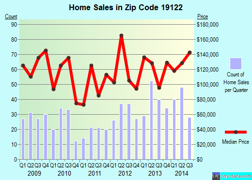
Property valuation of N Front Street, Philadelphia, PA: 2028, 2029, 2030, 2031, 2032, 2033, 2034, 2035, 2036, 2037 (tax assessments)
Other nearby streets: Hope Street  N Front Street (1)
N Front Street (2)
N Front Street (3)
N Front Street (4)
N Front Street (1)
N Front Street (2)
N Front Street (3)
N Front Street (4)
N Front Street (1)
N Front Street (2)
N Front Street (3)
N Front Street (4)
Listed properties vs overall distribution of properties in Philadelphia, PA:
Advertisements
2028 N Front Street
Philadelphia, PA 19122
Find on map >>
Owner: PAUL MAYBERRY
Assessed land value: $8,900 (it was $1,152 in 2009)
Total assessed value for property: $8,900 (it was $1,152 in 2009)
Market value: $8,900
Date of last market value change: 01/2013
Sale price: $2,500
Date the deed was transferred: 01/17/1991
Sale type: Deed of subdivision or consolidation or containing multiple properties or assemblage
Status of construction: Finished
Category: Vacant Land
Frontage: 19.25 feet
Depth: 62.25 feet
Shape: Rectangular
Topography: Street level
Garage type: None
View: Typical
Date the exterior condition was observed: 10/02/2012
Connection to sewer: Yes
Land area: 1,198.30 square feet
Assessments for tax year: 2014
2029 N Front Street
Philadelphia, PA 19122
Find on map >>
Owner: PAUL MAYBERRY
Assessed land value: $21,900
Total assessed value for property: $21,900
Market value: $21,900
Date of last market value change: 03/2013
Sale price: $2,100
Date the deed was transferred: 01/11/1988
Sale type: Forced, Sheriff, Bankruptcy or Court-ordered Sales, Condemnation, Deed in lieu of Condemnation
Status of construction: Finished
Category: Vacant Land
Usage: Residential - Light Commercial
Site type: Inside location on the block
Frontage: 21.41 feet
Depth: 102.07 feet
Shape: Irregular
Topography: Street level
View: Typical
Date the exterior condition was observed: 12/26/2012
Connection to sewer: Yes
Land area: 2,280 square feet
Assessments for tax year: 2014
2030 N Front Street
Philadelphia, PA 19122
Find on map >>
Owner: PAUL MAYBERRY
Assessed land value: $8,900 (it was $1,152 in 2009)
Total assessed value for property: $8,900 (it was $1,152 in 2009)
Market value: $8,900
Date of last market value change: 01/2013
Sale price: $2,500
Date the deed was transferred: 01/17/1991
Sale type: Deed of subdivision or consolidation or containing multiple properties or assemblage
Status of construction: Finished
Category: Vacant Land
Frontage: 19.25 feet
Depth: 62.25 feet
Shape: Rectangular
Topography: Street level
Garage type: None
View: Typical
Date the exterior condition was observed: 10/02/2012
Connection to sewer: Yes
Land area: 1,198.30 square feet
Assessments for tax year: 2014
2031 N Front Street
Philadelphia, PA 19122
Find on map >>
Owner: PAUL MAYBERRY
Assessed land value: $16,900
Total assessed value for property: $16,900
Market value: $16,900
Date of last market value change: 03/2013
Sale price: $10,000
Date the deed was transferred: 03/02/1987
Sale type: Deed of subdivision or consolidation or containing multiple properties or assemblage
Status of construction: Finished
Category: Vacant Land
Usage: Residential - Light Commercial
Site type: Inside location on the block
Frontage: 16.57 feet
Depth: 102.07 feet
Shape: Irregular
Topography: Street level
Garage type: None
View: Typical
Date the exterior condition was observed: 12/26/2012
Exterior condition: Average
Year property was built: 1900 (estimated)
Connection to sewer: Yes
Land area: 1,631 square feet
Assessments for tax year: 2014
2032 N Front Street
Philadelphia, PA 19122
Find on map >>
Owner: WEISS EVELYN JACK
Assessed land value: $8,900 (it was $736 in 2009)
Total assessed value for property: $8,900 (it was $736 in 2009)
Market value: $8,900
Date of last market value change: 01/2013
Sale price: $450
Date the deed was transferred: 06/20/1977
Sale type: Forced, Sheriff, Bankruptcy or Court-ordered Sales, Condemnation, Deed in lieu of Condemnation
Status of construction: Finished
Category: Vacant Land
Frontage: 19.25 feet
Depth: 62.25 feet
Shape: Rectangular
Topography: Street level
Garage type: None
View: Typical
Date the exterior condition was observed: 10/02/2012
Connection to sewer: Yes
Land area: 1,198.30 square feet
Assessments for tax year: 2014
2033 N Front Street
Philadelphia, PA 19122
Find on map >>
Owner: PAUL MAYBERRY
Assessed land value: $19,100
Total assessed value for property: $19,100
Market value: $19,100
Date of last market value change: 03/2013
Sale price: $10,000
Date the deed was transferred: 03/02/1987
Sale type: Deed of subdivision or consolidation or containing multiple properties or assemblage
Status of construction: Finished
Category: Vacant Land
Usage: Residential - Light Commercial
Site type: Inside location on the block
Frontage: 20 feet
Depth: 95.40 feet
Shape: Irregular
Topography: Street level
Garage type: None
View: Typical
Date the exterior condition was observed: 12/26/2012
Exterior condition: Average
Year property was built: 1900 (estimated)
Connection to sewer: Yes
Land area: 1,878 square feet
Assessments for tax year: 2014
2034 N Front Street
Philadelphia, PA 19122
Find on map >>
Owner: MAX REINMAN & ANNA REINMAN
Assessed land value: $9,000 (it was $832 in 2009)
Total assessed value for property: $9,000 (it was $832 in 2009)
Market value: $9,000
Date of last market value change: 01/2013
Sale price: $1
Date the deed was transferred: 03/16/1950
Status of construction: Finished
Category: Vacant Land
Frontage: 19.25 feet
Depth: 62.93 feet
Shape: Rectangular
Topography: Street level
Garage type: None
View: Typical
Date the exterior condition was observed: 10/02/2012
Connection to sewer: Yes
Land area: 1,211.58 square feet
Assessments for tax year: 2014
2035 N Front Street
Philadelphia, PA 19122
Find on map >>
Owner: PAUL MAYBERRY
Assessed land value: $10,400
Total assessed value for property: $10,400
Market value: $10,400
Date of last market value change: 03/2013
Sale price: $10,000
Date the deed was transferred: 03/02/1987
Sale type: Deed of subdivision or consolidation or containing multiple properties or assemblage
Status of construction: Finished
Category: Vacant Land
Usage: Residential - Light Commercial
Site type: Inside location on the block
Frontage: 18 feet
Depth: 81 feet
Shape: Irregular
Topography: Street level
Garage type: None
View: Typical
Date the exterior condition was observed: 12/26/2012
Year property was built: 1900 (estimated)
Connection to sewer: Yes
Land area: 1,402 square feet
Assessments for tax year: 2014
2036 N Front Street
Philadelphia, PA 19122
Find on map >>
Owner: MAX REINMAN & ANNA REINMAN
Assessed land value: $8,800 (it was $800 in 2009)
Total assessed value for property: $8,800 (it was $800 in 2009)
Market value: $8,800
Date of last market value change: 01/2013
Sale price: $1
Date the deed was transferred: 03/16/1950
Status of construction: Finished
Category: Vacant Land
Frontage: 19.17 feet
Depth: 62 feet
Shape: Rectangular
Topography: Street level
Garage type: None
View: Typical
Date the exterior condition was observed: 10/02/2012
Connection to sewer: Yes
Land area: 1,188.53 square feet
Assessments for tax year: 2014
2037 N Front Street
Philadelphia, PA 19122
Find on map >>
Owner: BARRILA NUNZIO
Assessed land value: $14,767
Assessed building value: $152,033
Total assessed value for property: $166,800
Market value: $166,800
Date of last market value change: 01/2013
Sale price: $1,500
Date the deed was transferred: 05/19/1970
Status of construction: Finished
Category: Store with Dwelling
Usage: Residential - Light Commercial
Site type: Inside location on the block
Frontage: 17 feet
Depth: 80.68 feet
Shape: Rectangular
Topography: Street level
Garage type: None
View: Typical
Date the exterior condition was observed: 02/22/2012
Exterior condition: Average
Year property was built: 1875 (estimated)
Basement type: Finished
Type of heater or heating system: Undetermined
Connection to sewer: Yes
Separation of utilities: Part separate - not central or all separate
Land area: 1,371.73 square feet
Total dwelling livable area: 1,269 square feet
Assessments for tax year: 2014
Other nearby streets: Hope Street
N Front Street (1)
N Front Street (2)
N Front Street (3)
N Front Street (4)
N Front Street (1)
N Front Street (2)
N Front Street (3)
N Front Street (4)

Recent posts about Philadelphia, Pennsylvania on our local forum with over 2,400,000 registered users. Philadelphia is mentioned 39,643 times on our forum:

Settings
X

Recently Added Photos

Philadelphia, PA
Philadelphia, PA

Philadelphia, PA

Philadelphia, PA

Philadelphia, PA

Philadelphia, PA

Philadelphia, PA
Philadelphia, PA

Philadelphia, PA

Philadelphia, PA

Philadelphia, PA

Philadelphia, PA
Request disassociating your name from street-level assessment address

Recent home sales, price trends, and home value evaluator powered by Onboard Informatics
© 2024 Onboard Informatics. Information is deemed reliable but not guaranteed.
© 2024 Onboard Informatics. Information is deemed reliable but not guaranteed.
Some parts © 2024 Advameg, Inc.
Compilation, repackaging, or reproduction prohibited. Users are forewarned that it is incumbent upon them to verify information with the responsible state agency. Advameg, Inc. does not guarantee the data presented is up-to-date nor does it assume responsibility for updating it. Therefore any names, owners or addresses may have changed. Use of any information published here to contact the persons might be prohibited by the law.