South Dona Ana, New Mexico
Submit your own pictures of this place and show them to the world
- OSM Map
- General Map
- Google Map
- MSN Map

| Males: 12,936 | |
| Females: 13,527 |
| Median resident age: | 29.6 years |
| New Mexico median age: | 34.6 years |
Zip code: 88021
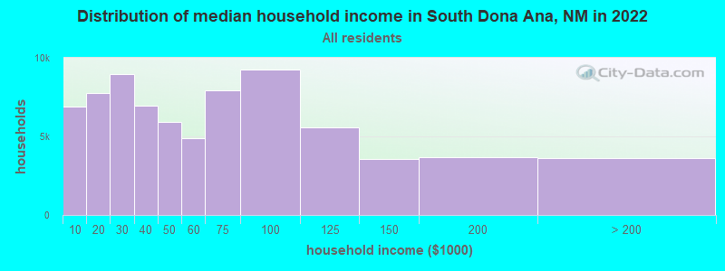
| South Dona Ana: | $45,394 |
| NM: | $59,726 |
Estimated per capita income in 2022: $20,661 (it was $10,451 in 2000)
South Dona Ana CCD income, earnings, and wages data
Estimated median house or condo value in 2022: $178,801 (it was $62,500 in 2000)
| South Dona Ana: | $178,801 |
| NM: | $243,100 |
Mean prices in 2022: all housing units: $217,959; detached houses: $251,095; townhouses or other attached units: $205,475; in 2-unit structures: $389,169; in 3-to-4-unit structures: $329,519; in 5-or-more-unit structures: $184,071; mobile homes: $97,843
South Dona Ana, NM residents, houses, and apartments details
Detailed information about poverty and poor residents in South Dona Ana, NM


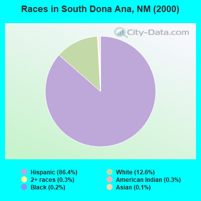
- 20,17786.4%Hispanic
- 2,94012.6%White alone
- 660.3%American Indian alone
- 750.3%Two or more races
- 560.2%Black alone
- 270.1%Asian alone
- 150.06%Other race alone
- 60.03%Native Hawaiian and Other
Pacific Islander alone
Races in South Dona Ana detailed stats: ancestries, foreign born residents, place of birth
 Recent articles from our blog. Our writers, many of them Ph.D. graduates or candidates, create easy-to-read articles on a wide variety of topics.
Current Local Time: MST time zone
Land area: 1024.2 square miles.
Population density: 26 people per square mile (very low).

| South Dona Ana CCD: | 0.9% ($581) |
| New Mexico: | 0.7% ($699) |
Nearest city with pop. 50,000+: El Paso, TX  (21.6 miles , pop. 563,662).
Nearest city with pop. 1,000,000+: Phoenix, AZ (329.1 miles , pop. 1,321,045).
Nearest cities:
), ), ), Latitude: 31.95 N, Longitude: 106.74 W

| Here: | 4.2% |
| New Mexico: | 3.6% |
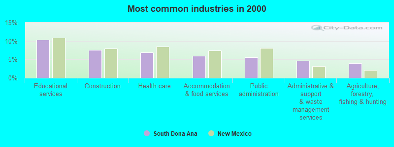
- Educational services (10.3%)
- Construction (7.6%)
- Health care (6.8%)
- Accommodation & food services (6.0%)
- Public administration (5.6%)
- Administrative & support & waste management services (4.6%)
- Agriculture, forestry, fishing & hunting (4.0%)
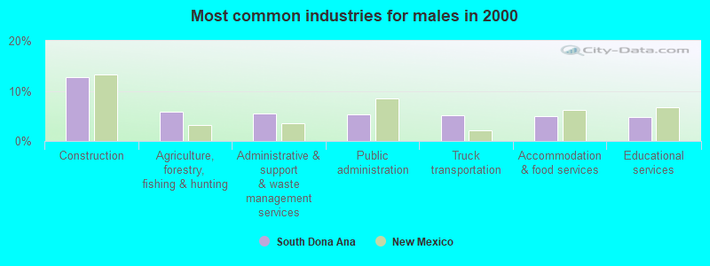
- Construction (12.8%)
- Agriculture, forestry, fishing & hunting (5.8%)
- Administrative & support & waste management services (5.5%)
- Public administration (5.4%)
- Truck transportation (5.1%)
- Accommodation & food services (5.0%)
- Educational services (4.9%)
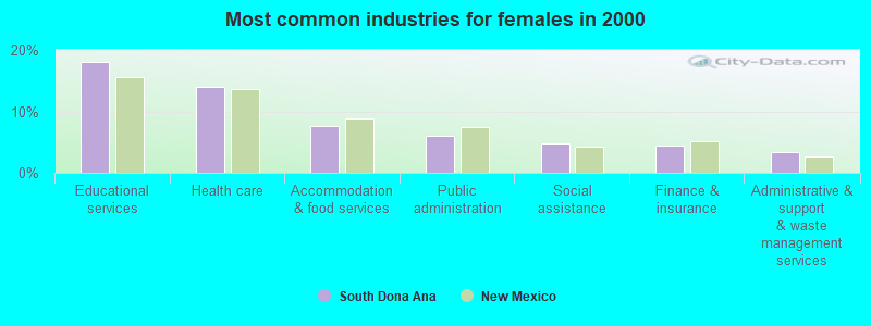
- Educational services (18.1%)
- Health care (14.0%)
- Accommodation & food services (7.6%)
- Public administration (6.0%)
- Social assistance (4.7%)
- Finance & insurance (4.5%)
- Administrative & support & waste management services (3.4%)
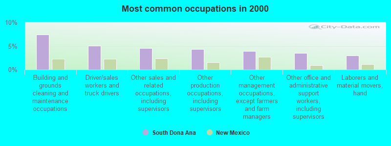
- Building and grounds cleaning and maintenance occupations (7.4%)
- Driver/sales workers and truck drivers (5.1%)
- Other sales and related occupations, including supervisors (4.5%)
- Other production occupations, including supervisors (4.3%)
- Other management occupations, except farmers and farm managers (3.9%)
- Other office and administrative support workers, including supervisors (3.5%)
- Laborers and material movers, hand (3.0%)
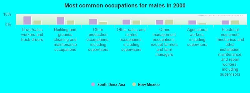
- Driver/sales workers and truck drivers (8.1%)
- Building and grounds cleaning and maintenance occupations (7.2%)
- Other production occupations, including supervisors (5.7%)
- Other sales and related occupations, including supervisors (5.2%)
- Other management occupations, except farmers and farm managers (4.4%)
- Agricultural workers, including supervisors (4.3%)
- Electrical equipment mechanics and other installation, maintenance, and repair workers, including supervisors (4.3%)
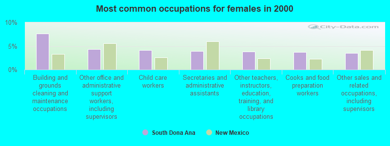
- Building and grounds cleaning and maintenance occupations (7.6%)
- Other office and administrative support workers, including supervisors (4.3%)
- Child care workers (4.1%)
- Secretaries and administrative assistants (4.0%)
- Other teachers, instructors, education, training, and library occupations (3.9%)
- Cooks and food preparation workers (3.7%)
- Other sales and related occupations, including supervisors (3.6%)
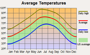
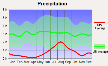
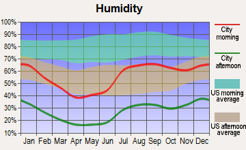
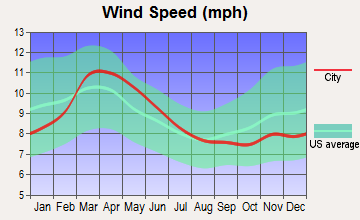
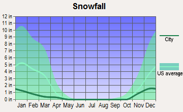
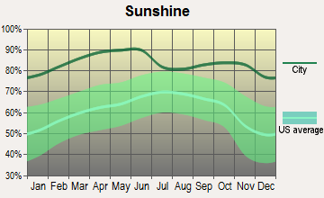
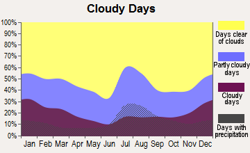
Average climate in South Dona Ana, New Mexico
Based on data reported by over 4,000 weather stations
(lower is better)
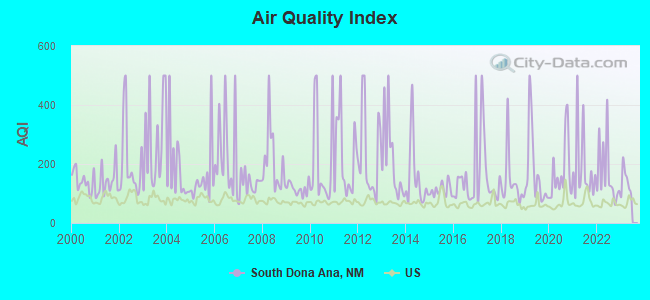
Air Quality Index (AQI) level in 2022 was 165. This is significantly worse than average.
| City: | 165 |
| U.S.: | 73 |
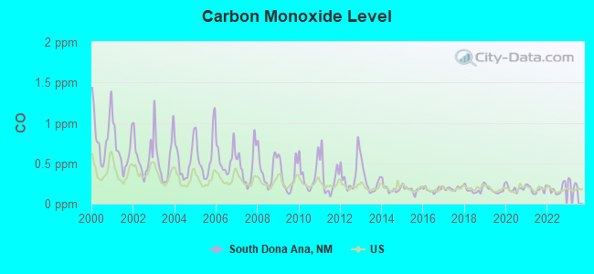
Carbon Monoxide (CO) [ppm] level in 2022 was 0.180. This is better than average. Closest monitor was 11.5 miles away from the city center.
| City: | 0.180 |
| U.S.: | 0.251 |
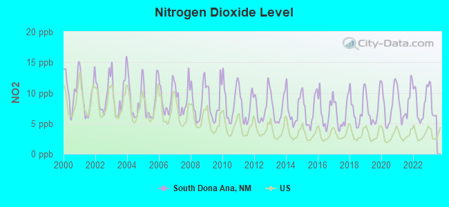
Nitrogen Dioxide (NO2) [ppb] level in 2022 was 8.24. This is significantly worse than average. Closest monitor was 9.0 miles away from the city center.
| City: | 8.24 |
| U.S.: | 5.11 |
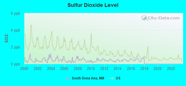
Sulfur Dioxide (SO2) [ppb] level in 2017 was 0.522. This is significantly better than average. Closest monitor was 6.6 miles away from the city center.
| City: | 0.522 |
| U.S.: | 1.515 |
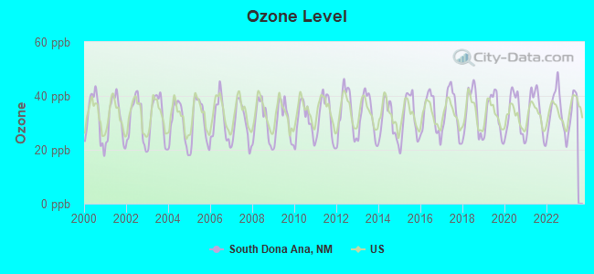
Ozone [ppb] level in 2022 was 34.2. This is about average. Closest monitor was 6.6 miles away from the city center.
| City: | 34.2 |
| U.S.: | 33.3 |
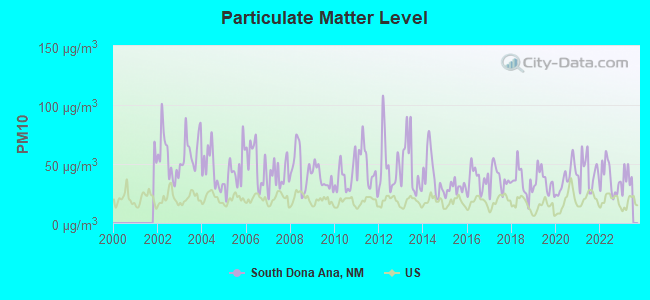
Particulate Matter (PM10) [µg/m3] level in 2022 was 37.6. This is significantly worse than average. Closest monitor was 9.2 miles away from the city center.
| City: | 37.6 |
| U.S.: | 19.2 |
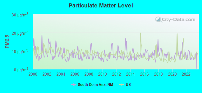
Particulate Matter (PM2.5) [µg/m3] level in 2022 was 7.25. This is about average. Closest monitor was 9.2 miles away from the city center.
| City: | 7.25 |
| U.S.: | 8.11 |
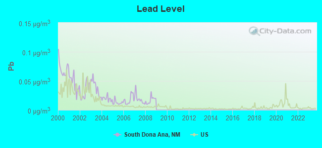
Lead (Pb) [µg/m3] level in 2008 was 0.0172. This is significantly worse than average. Closest monitor was 9.1 miles away from the city center.
| City: | 0.0172 |
| U.S.: | 0.0093 |
Earthquake activity:
South Dona Ana-area historical earthquake activity is significantly above New Mexico state average. It is 468% greater than the overall U.S. average.On 4/14/1995 at 00:32:56, a magnitude 5.7 (5.6 MB, 5.7 MS, 5.7 MW, Depth: 11.1 mi, Class: Moderate, Intensity: VI - VII) earthquake occurred 230.7 miles away from the city center
On 6/29/2014 at 04:59:35, a magnitude 5.3 (5.3 MW, Depth: 4.0 mi) earthquake occurred 148.6 miles away from South Dona Ana center
On 1/4/2006 at 08:32:32, a magnitude 6.6 (6.6 MW, Depth: 8.7 mi, Class: Strong, Intensity: VII - IX) earthquake occurred 414.7 miles away from the city center
On 6/28/1992 at 11:57:34, a magnitude 7.6 (6.2 MB, 7.6 MS, 7.3 MW, Depth: 0.7 mi, Class: Major, Intensity: VIII - XII) earthquake occurred 588.0 miles away from South Dona Ana center, causing 3 deaths (1 shaking deaths, 2 other deaths) and 400 injuries, causing $100,000,000 total damage and $40,000,000 insured losses
On 5/19/1940 at 04:36:40, a magnitude 7.2 (7.2 UK) earthquake occurred 529.2 miles away from South Dona Ana center, causing $33,000,000 total damage
On 12/31/1934 at 18:45:56, a magnitude 7.1 (7.1 UK) earthquake occurred 529.6 miles away from South Dona Ana center
Magnitude types: body-wave magnitude (MB), surface-wave magnitude (MS), moment magnitude (MW)
Natural disasters:
The number of natural disasters in Dona Ana County (8) is smaller than the US average (15).Major Disasters (Presidential) Declared: 5
Emergencies Declared: 2
Causes of natural disasters: Floods: 4, Storms: 3, Fires: 2, Heavy Rain: 1, Hurricane: 1, Mudslide: 1, Other: 1 (Note: some incidents may be assigned to more than one category).
Hospitals and medical centers near South Dona Ana:
- NM CUIDADO CASERO HOME HEALTH, LLC (Home Health Center, about 9 miles away; ANTHONY, NM)
- SU CASA HEALTH CARE SERVICES OF NEW MEXICO (Home Health Center, about 10 miles away; SANTA TERESA, NM)
- ARMONIA HOME HEALTH CARE AGENCY LLC (Home Health Center, about 10 miles away; EL PASO, TX)
- PEAK PSYCHIATRIC HOSPITAL,THE (Hospital, about 11 miles away; SANTA TERESA, NM)
- PEAK PSYCH HOSPITAL (Hospital, about 11 miles away; SANTA TERESA, NM)
- NEW HOPE COMMUNITY LIVING V (Hospital, about 12 miles away; EL PASO, TX)
- VICTORIA HOME HEALTH CARE (Home Health Center, about 13 miles away; EL PASO, TX)
Amtrak station near South Dona Ana:
Colleges/universities with over 2000 students nearest to South Dona Ana:
- The University of Texas at El Paso (about 19 miles; El Paso, TX; Full-time enrollment: 18,008)
- Vista College (about 23 miles; El Paso, TX; FT enrollment: 3,453)
- New Mexico State University-Dona Ana (about 23 miles; Las Cruces, NM; FT enrollment: 5,640)
- New Mexico State University-Main Campus (about 24 miles; Las Cruces, NM; FT enrollment: 14,497)
- El Paso Community College (about 25 miles; El Paso, TX; FT enrollment: 19,576)
- Western New Mexico University (about 107 miles; Silver City, NM; FT enrollment: 2,456)
- Eastern New Mexico University-Roswell Campus (about 161 miles; Roswell, NM; FT enrollment: 2,212)
Points of interest:
Notable locations in South Dona Ana: Mount Riley (A), Nunn Ranch (B), O D Ranch (C), Phillips Ranch (D), Red Windmill (E), Sweetwater Windmill (F), X-Seven Ranch (G), The Malpais (H), Junes Mill (I), Strauss Ranch Headquarters (J), Fitzgerald Ranch (K), Braid Foot Ranch (L), Norwood Ranch (M), Smugglers Hidaway (N), Sunland Park Racetrack (O), Birchfield Ranch (P), Afton Pumping Station (Q), International Boundary Marker Number One (R), Cox Ranch (S), Hall and Primm Ranch (T). Display/hide their locations on the map
Churches in South Dona Ana include: Saint Lukes Church (A), Saint Michael Church (B), San Jose Catholic Church Historic Site (C), La Mesa United Methodist Church (D), San Luis Church (E), La Mesa Baptist Church (F), Santa Niña Church (G). Display/hide their locations on the map
Cemeteries: San Luis Cemetery (1), Saint Josephs Cemetery (2). Display/hide their locations on the map
Lakes and reservoirs: La Mesa Lake (A), Mauries Lake (B), Black Hills Tank (C), Johnson Ranch Tank (D), Bills Tank (E), Barbaras Tank (F), Mauries Tank (G), Mesquite Tank (H). Display/hide their locations on the map
Parks in South Dona Ana include: Aden Lava Flow Wilderness Study Area (1), West Potrillo Mountains/Mount Riley Wilderness Study Area (2). Display/hide their locations on the map
| This place: | 3.2 people |
| New Mexico: | 2.5 people |
| This place: | 80.9% |
| Whole state: | 65.5% |
| This place: | 5.0% |
| Whole state: | 8.2% |
Likely homosexual households (counted as self-reported same-sex unmarried-partner households)
- Lesbian couples: 0.3% of all households
- Gay men: 0.2% of all households
| This place: | 31.4% |
| Whole state: | 18.4% |
| This place: | 11.9% |
| Whole state: | 7.8% |
35 people in military barracks, etc. in 2000
For population 15 years and over in South Dona Ana:
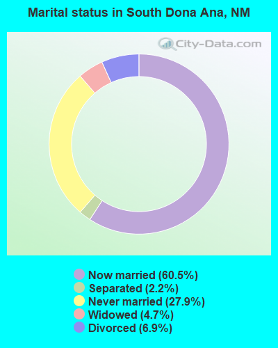
- Never married: 27.9%
- Now married: 60.5%
- Separated: 2.2%
- Widowed: 4.7%
- Divorced: 6.9%
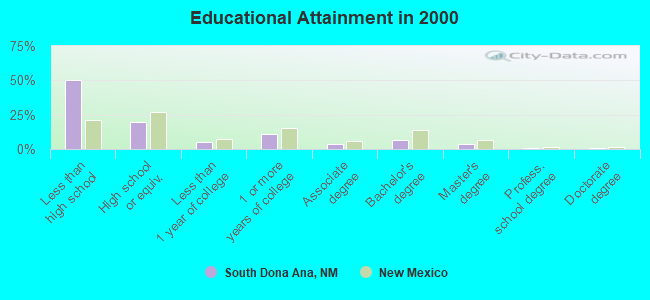
For population 25 years and over in South Dona Ana:
- High school or higher: 50.1%
- Bachelor's degree or higher: 11.0%
- Graduate or professional degree: 4.4%
- Unemployed: 9.2%
- Mean travel time to work (commute): 24.5 minutes
| Here: | 27.6 |
| New Mexico average: | 14.5 |
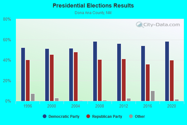
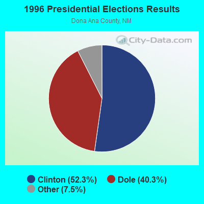
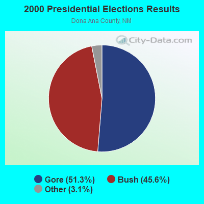

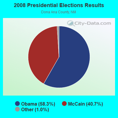
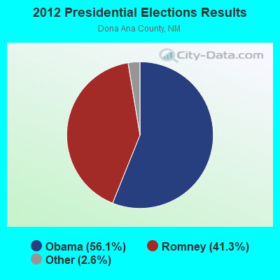
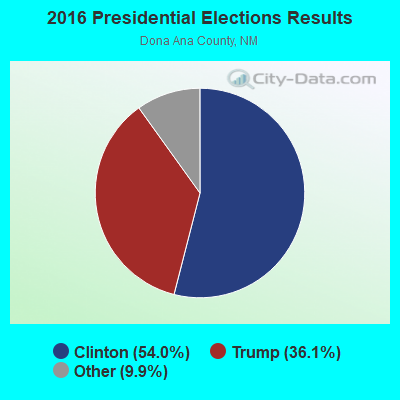
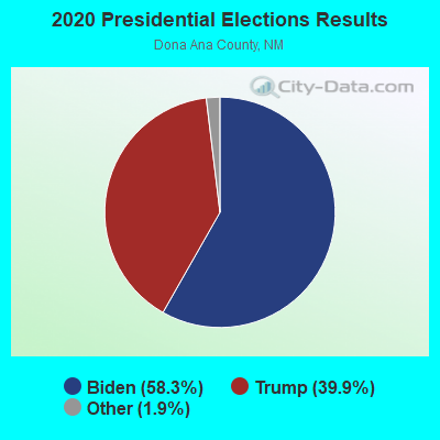
Graphs represent county-level data. Detailed 2008 Election Results
Religion statistics for South Dona Ana, NM (based on Dona Ana County data)
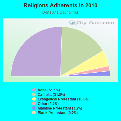
| Religion | Adherents | Congregations |
|---|---|---|
| Catholic | 66,491 | 26 |
| Evangelical Protestant | 22,120 | 114 |
| Other | 6,705 | 25 |
| Mainline Protestant | 6,640 | 17 |
| Black Protestant | 353 | 3 |
| Orthodox | 30 | 1 |
| None | 106,894 | - |
Food Environment Statistics:
| This county: | 0.96 / 10,000 pop. |
| New Mexico: | 1.44 / 10,000 pop. |
| This county: | 0.15 / 10,000 pop. |
| New Mexico: | 0.21 / 10,000 pop. |
| Dona Ana County: | 0.20 / 10,000 pop. |
| New Mexico: | 0.32 / 10,000 pop. |
| Dona Ana County: | 2.73 / 10,000 pop. |
| New Mexico: | 4.06 / 10,000 pop. |
| This county: | 5.35 / 10,000 pop. |
| New Mexico: | 7.12 / 10,000 pop. |
| Dona Ana County: | 5.7% |
| State: | 6.4% |
| Dona Ana County: | 22.7% |
| State: | 22.1% |
| Dona Ana County: | 15.2% |
| New Mexico: | 11.5% |
6.15% of this county's 2021 resident taxpayers lived in other counties in 2020 ($52,361 average adjusted gross income)
| Here: | 6.15% |
| New Mexico average: | 6.50% |
0.06% of residents moved from foreign countries ($655 average AGI)
Dona Ana County: 0.06% New Mexico average: 0.07%
Top counties from which taxpayers relocated into this county between 2020 and 2021:
| from El Paso County, TX | |
| from Bernalillo County, NM | |
| from Otero County, NM |
5.98% of this county's 2020 resident taxpayers moved to other counties in 2021 ($48,402 average adjusted gross income)
| Here: | 5.98% |
| New Mexico average: | 6.53% |
0.03% of residents moved to foreign countries ($376 average AGI)
Dona Ana County: 0.03% New Mexico average: 0.05%
Top counties to which taxpayers relocated from this county between 2020 and 2021:
| to El Paso County, TX | |
| to Bernalillo County, NM | |
| to Otero County, NM |
Strongest AM radio stations in South Dona Ana:
- KELP (1590 AM; 50 kW; EL PASO, TX; Owner: MCCLATCHEY BROADCASTING)
- KXPL (1060 AM; daytime; 10 kW; EL PASO, TX; Owner: K-FINA RESULTS, INC.)
- KTSM (690 AM; 10 kW; EL PASO, TX; Owner: CCB TEXAS LICENSES, L.P.)
- KROD (600 AM; 5 kW; EL PASO, TX; Owner: REGENT LICENSEE OF EL PASO, INC.)
- KSVE (1150 AM; 10 kW; EL PASO, TX; Owner: ENTRAVISION HOLDINGS, LLC)
- KBNA (920 AM; 10 kW; EL PASO, TX; Owner: TICHENOR LICENSE CORPORATION ("TLC"))
- KAMA (750 AM; 10 kW; EL PASO, TX; Owner: TICHENOR LICENSE CORPORATION ("TLC"))
- KSNM (570 AM; 5 kW; LAS CRUCES, NM; Owner: SUNRISE BROADCASTING INC.)
- KHEY (1380 AM; 5 kW; EL PASO, TX; Owner: CCB TEXAS LICENSES, L.P.)
- KINF (1020 AM; 50 kW; ROSWELL, NM; Owner: JAMES CRYSTAL HOLDINGS OF NEW MEXICO, INC.)
- KVIV (1340 AM; 1 kW; EL PASO, TX; Owner: SPANISH CHRISTIAN BROADCASTING OF EL PASO, INC.)
- KOBE (1450 AM; 1 kW; LAS CRUCES, NM; Owner: EDWARDS MEDIA LTD. CO.)
- KKOB (770 AM; 50 kW; ALBUQUERQUE, NM; Owner: CITADEL BROADCASTING COMPANY)
Strongest FM radio stations in South Dona Ana:
- KOFX (92.3 FM; EL PASO, TX; Owner: ENTRAVISION HOLDINGS, LLC)
- KTSM-FM (99.9 FM; EL PASO, TX; Owner: CCB TEXAS LICENSES, L.P.)
- K219BX (91.7 FM; EL PASO, ETC., TX; Owner: FAMILY STATIONS, INC.)
- KSII (93.1 FM; EL PASO, TX; Owner: REGENT LICENSEE OF EL PASO, INC.)
- KINT-FM (93.9 FM; EL PASO, TX; Owner: ENTRAVISION HOLDINGS, LLC)
- KHEY-FM (96.3 FM; EL PASO, TX; Owner: CCB TEXAS LICENSES, L.P.)
- KLAQ (95.5 FM; EL PASO, TX; Owner: REGENT LICENSEE OF EL PASO, INC.)
- KHRO (94.7 FM; EL PASO, TX; Owner: ENTRAVISION HOLDINGS, LLC)
- KPRR (102.1 FM; EL PASO, TX; Owner: CCB TEXAS LICENSES, L.P.)
- KVER (91.1 FM; EL PASO, TX; Owner: WORLD RADIO NETWORK, INC.)
- KXCR (89.5 FM; EL PASO, TX; Owner: EDUCATIONAL MEDIA FOUNDATION)
- KBNA-FM (97.5 FM; EL PASO, TX; Owner: TICHENOR LICENSE CORPORATION ("TLC"))
- KTEP (88.5 FM; EL PASO, TX; Owner: UNIVERSITY OF TEXAS AT EL PASO)
- K212EO (90.3 FM; EL PASO, TX; Owner: CALVARY CHAPEL OF TWIN FALLS, INC.)
- KROL (99.5 FM; LAS CRUCES, NM; Owner: RIO GRANDE CHRISTIAN BROADCASTING CO)
- KHQT (103.1 FM; LAS CRUCES, NM; Owner: RICHARDSON COMMERCIAL CORPORATION)
- K211EN (90.1 FM; LAS CRUCES, NM; Owner: CALVARY CHAPEL OF TWIN FALLS, INC.)
- K220GF (91.9 FM; LAS CRUCES, NM; Owner: PENSACOLA CHRISTIAN COLLEGE, INC.)
- KRWG (90.7 FM; LAS CRUCES, NM; Owner: REGENTS OF NEW MEXICO STATE UNIVERSITY)
TV broadcast stations around South Dona Ana:
- KTYO (Channel 48; LAS CRUCES, NM; Owner: COUNCIL TREE COMMUNICATIONS VI, L.P.)
- KTSM-TV (Channel 9; EL PASO, TX; Owner: COMCORP OF EL PASO LICENSE CORP.)
- KVIA-TV (Channel 7; EL PASO, TX; Owner: NPG OF TEXAS, L.P.)
- KSCE (Channel 38; EL PASO, TX; Owner: CHANNEL 38 CHRISTIAN TELEVISION)
- K42DJ (Channel 42; LAS CRUCES, NM; Owner: KOB-TV, LLC)
- KFOX-TV (Channel 14; EL PASO, TX; Owner: KTVU PARTNERSHIP)
- KINT-TV (Channel 26; EL PASO, TX; Owner: ENTRAVISION HOLDINGS, LLC)
- KRWG-TV (Channel 22; LAS CRUCES, NM; Owner: REGENTS OF NEW MEXICO STATE UNIVERSITY)
- KTFN (Channel 65; EL PASO, TX; Owner: ENTRAVISION HOLDINGS, LLC)
- KDBC-TV (Channel 4; EL PASO, TX; Owner: KDBC-TV LIMITED PARTNERSHIP)
FCC Registered Microwave Towers:
1- NM02116A, 1441 Mercantile Avenue (Lat: 31.949111 Lon: -106.665361), Type: Mtower, Structure height: 45.7 m, Call Sign: WQWH933,
Assigned Frequencies: 17865.0 MHz, Grant Date: 08/27/2015, Expiration Date: 08/27/2025, Cancellation Date: 03/18/2024, Certifier: David Werblow, Registrant: T-Mobile Usa, Inc., 12920 Se 38th Street, Bellevue, WA 98006, Phone: (425) 383-8401, Fax: (425) 383-4040, Email:
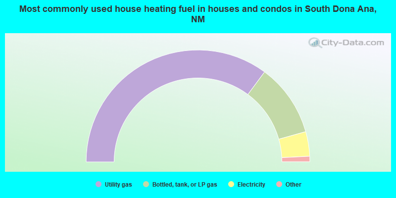
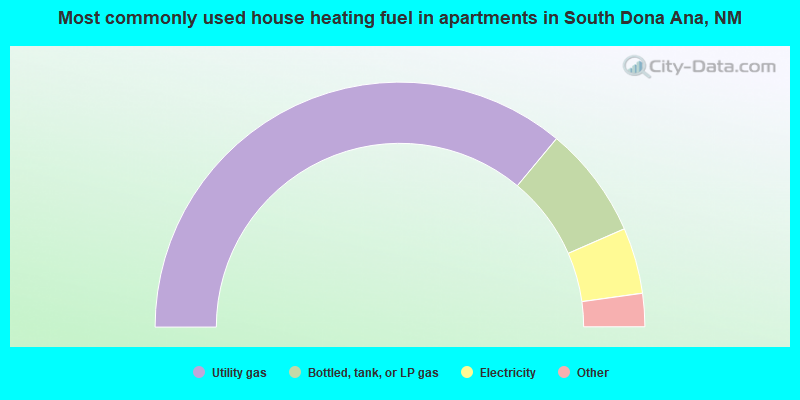
- 70.3%Utility gas
- 21.0%Bottled, tank, or LP gas
- 7.1%Electricity
- 0.7%Wood
- 0.4%No fuel used
- 0.4%Other fuel
- 0.1%Solar energy
- 72.1%Utility gas
- 14.8%Bottled, tank, or LP gas
- 8.7%Electricity
- 2.2%No fuel used
- 2.2%Wood
South Dona Ana compared to New Mexico state average:
- Black race population percentage significantly below state average.
- Hispanic race population percentage above state average.
- Median age significantly below state average.
- Foreign-born population percentage significantly below state average.
- Length of stay since moving in significantly above state average.
- Number of rooms per house significantly below state average.
- House age significantly below state average.
- Percentage of population with a bachelor's degree or higher below state average.
South Dona Ana on our top lists:
- #18 on the list of "Top 101 cities with largest percentage of females in industries: electrical equipment, appliances, and components (population 5,000+)"
- #31 on the list of "Top 101 cities with largest percentage of females in occupations: motor vehicle operators except bus and truck drivers (population 5,000+)"
- #46 on the list of "Top 101 cities with largest percentage of females in occupations: pipelayers, plumbers, pipefitters, and steamfitters (population 5,000+)"
- #46 on the list of "Top 100 cities with largest land areas (pop. 5,000+)"
- #47 on the list of "Top 101 cities with largest percentage of males in industries: retail florists (population 5,000+)"
- #58 on the list of "Top 101 cities with largest percentage of males in occupations: painters and paperhangers (population 5,000+)"
- #62 on the list of "Top 101 cities with largest percentage of males in occupations: other teachers and instructors, education, training, and library occupations (population 5,000+)"
- #65 on the list of "Top 101 cities with largest percentage of females in occupations: child care workers (population 5,000+)"
- #71 on the list of "Top 101 cities with largest percentage of males in occupations: agricultural workers including supervisors (population 5,000+)"
- #71 on the list of "Top 101 cities with largest percentage of males in industries: leather and allied products (population 5,000+)"
- #76 on the list of "Top 101 cities with largest percentage of females in industries: apparel (population 5,000+)"
- #83 on the list of "Top 101 cities with largest percentage of females in industries: miscellaneous durable goods merchant wholesalers (population 5,000+)"
- #83 on the list of "Top 101 cities with largest percentage of males in industries: truck transportation (population 5,000+)"
- #87 on the list of "Top 101 cities with largest percentage of females in industries: alcoholic beverages merchant wholesalers (population 5,000+)"
- #94 on the list of "Top 101 cities with largest percentage of males in industries: private households (population 5,000+)"
- #100 on the list of "Top 101 cities with the most people below 50% of the poverty level, excluding cities with 15% or more of residents in college and with the median age below 28 (population 5,000+)"
- #2 on the list of "Top 101 counties with the highest Particulate Matter (PM10) Annual air pollution readings in 2012 (µg/m3)"
- #7 on the list of "Top 101 counties with the highest Particulate Matter (PM2.5) Annual air pollution readings in 2012 (µg/m3)"
- #33 on the list of "Top 101 counties with highest percentage of residents voting for 3rd party candidates in the 2012 Presidential Election (pop. 50,000+)"
- #34 on the list of "Top 101 counties with the worst general health status score of residents (1-5), 3 years of data"
- #53 on the list of "Top 101 counties with the lowest percentage of residents that drank alcohol in the past 30 days"