Bridge Statistics for Abernathy, Texas (TX)
Condition, Traffic, Stress, Structural Evaluation, Project Costs
- National Bridge Inventory (NBI) Statistics
- 12Number of bridges
- 105ft / 32.2mTotal length
- $16,000Total costs
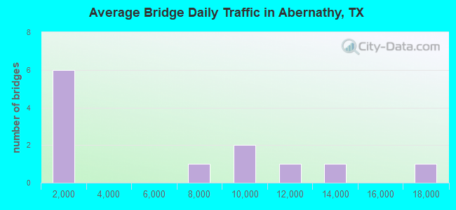
- 69,145Total average daily traffic
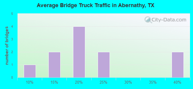
- 12,641Total average daily truck traffic
- National Bridge Inventory (NBI) Registered Bridges for Abernathy
- No street view available for this location
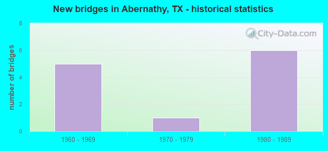
- New bridges - historical statistics
- 51960-1969
- 11970-1979
- 61980-1989
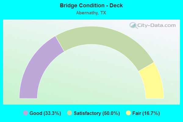
- Bridge Condition - Deck
- 33.3%Good
- 50.0%Satisfactory
- 16.7%Fair
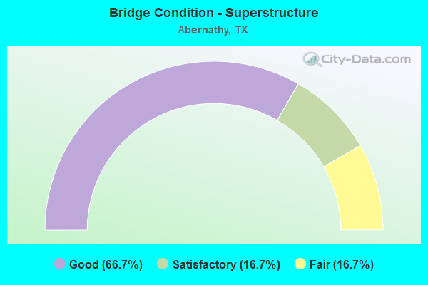
- Bridge Condition - Superstructure
- 66.7%Good
- 16.7%Satisfactory
- 16.7%Fair
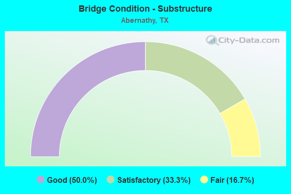
- Bridge Condition - Substructure
- 50.0%Good
- 33.3%Satisfactory
- 16.7%Fair
Find on map >> Show street view
Structure Number: 5096000670405, Location: 1.90 MI S OF SH 194 (Lat: 34.187458, Lng: -101.749544), Route carried "on" structure: Interstate 27, Year Built: 1967, Status: Open, Structure Length: 6.10m (20.01ft), Average Daily Traffic: 6,682 (year 2019), Truck Traffic: 17%, Average Future Daily Traffic: 7,230 (year 2033), Design Load: HS 20, Features Intersected: US 70
Minimum Vertical Clearance: 30+ m (98+ ft), Kilometerpoint: 44.918, Lanes on structure: 2, Lanes under structure: 8, Owner: State Highway Agency, Approaching Roadway Width: 12.2m (40.0ft), Skew: 2 degrees, Material/Design: Prestressed concrete, Design/Construction: Stringer/Multi-beam, Number Of Spans In Main Unit: 2, Number Of Approach Spans: 2, Length of Maximum Span: 18.3m (60.0ft), Curb-To-Curb Width: 12.4m (40.7ft), Out-to-Out Width: 12.9m (42.3ft)
Condition: Deck: Good, Superstructure: Good, Substructure: Good, Operating Rating: 68.0 metric tons, Method Used To Determine Operating Rating: Load Factor (LF), Inventory Rating: 34.5 metric tons, Method Used To Determine Inventory Rating: Load Factor (LF), Structural Evaluation: Better than present minimum criteria, Deck Geometry: Better than present minimum criteria, Underclear: Meets minimum limits, Approach Roadway Alignment: Equal to present desirable criteria, Designated Inspection Frequency: Every 24 months, Inspection Date: August 2021, Deck Structure Type: Concrete Cast-file-Place
Find on map >> Show street view
Structure Number: 50960006706045, Location: 2.70 MI S OF FM 54 (Lat: 33.839872, Lng: -101.842117), Route carried "on" structure: Interstate 27, Year Built: 1962, Year Reconstructed: 1980, Status: Open, Structure Length: 4.85m (15.91ft), Average Daily Traffic: 13,530 (year 2020), Truck Traffic: 21%, Average Future Daily Traffic: 15,910 (year 2033), Features Intersected: N LOOP 369
Minimum Vertical Clearance: 30+ m (98+ ft), Kilometerpoint: 1.469, Lanes on structure: 4, Lanes under structure: 4, Owner: State Highway Agency, Approaching Roadway Width: 24.4m (80.1ft), Skew: 30 degrees, Material/Design: Concrete continuous, Design/Construction: Slab, Number Of Spans In Main Unit: 4, Length of Maximum Span: 13.7m (44.9ft), Curb-To-Curb Width: 24.3m (79.7ft), Out-to-Out Width: 25.6m (84.0ft)
Condition: Deck: Fair, Superstructure: Fair, Substructure: Satisfactory, Operating Rating: 68.0 metric tons, Method Used To Determine Operating Rating: Load Factor (LF), Inventory Rating: 40.8 metric tons, Method Used To Determine Inventory Rating: Load Factor (LF), Structural Evaluation: Somewhat better than minimum adequacy, Deck Geometry: Superior to present desirable criteria, Underclear: Meets minimum limits, Approach Roadway Alignment: Equal to present desirable criteria, Length Of Structure Improvement: 4.88m (16.01ft), Designated Inspection Frequency: Every 24 months, Inspection Date: August 2021, Bridge Improvement Cost: $13,000, Roadway Improvement Cost: $3,000, Total Project Cost: $16,000, Deck Structure Type: Concrete Cast-file-Place, Wearing Surface/Protective System: Wearing Surface: Monolithic Concrete
Find on map >> Show street view
Structure Number: 50960006706091, Location: 3.35 MI S OF FM 54 (Lat: 33.831869, Lng: -101.840922), Route carried "on" structure: State highway 2060, Year Built: 1980, Status: Open, Structure Length: 4.24m (13.91ft), Average Daily Traffic: 700 (year 2010), Average Future Daily Traffic: 1,000 (year 2030), Design Load: HS 20, Features Intersected: IH 27
Minimum Vertical Clearance: 30+ m (98+ ft), Kilometerpoint: 0.805, Lanes on structure: 4, Lanes under structure: 4, Owner: State Highway Agency, Approaching Roadway Width: 17.1m (56.1ft), Material/Design: Prestressed concrete, Design/Construction: Box Beam or Girders - Multiple, Number Of Spans In Main Unit: 2, Length of Maximum Span: 21.0m (68.9ft), Curb or Sidewalk Widths: Left: 1.4m (4.6ft), Right: 1.4m (4.6ft), Curb-To-Curb Width: 17.2m (56.4ft), Out-to-Out Width: 20.7m (67.9ft)
Condition: Deck: Good, Superstructure: Good, Substructure: Good, Operating Rating: 54.4 metric tons, Method Used To Determine Operating Rating: Assigned rating based on Load Factor Design (LFD) reported in metric tons, Inventory Rating: 32.7 metric tons, Method Used To Determine Inventory Rating: Assigned rating based on Load Factor Design (LFD) reported in metric tons, Structural Evaluation: Better than present minimum criteria, Deck Geometry: Somewhat better than minimum adequacy, Underclear: Meets minimum limits, Approach Roadway Alignment: Equal to present desirable criteria, Designated Inspection Frequency: Every 24 months, Inspection Date: August 2021, Deck Structure Type: Other, Wearing Surface/Protective System: Wearing Surface: Monolithic Concrete
Find on map >> Show street view
Structure Number: 50960006706094, Location: 3.30 MI N OF FM 2060 (Lat: 33.876375, Lng: -101.853850), Route carried "on" structure: Interstate 27, Year Built: 1981, Status: Open, Structure Length: 6.10m (20.01ft), Average Daily Traffic: 8,066 (year 2019), Truck Traffic: 17%, Average Future Daily Traffic: 8,560 (year 2033), Design Load: HS 20, Features Intersected: FM 54
Minimum Vertical Clearance: 30+ m (98+ ft), Kilometerpoint: 5.795, Lanes on structure: 2, Lanes under structure: 4, Owner: State Highway Agency, Approaching Roadway Width: 11.6m (38.1ft), Material/Design: Prestressed concrete continuous, Design/Construction: Stringer/Multi-beam, Number Of Spans In Main Unit: 2, Length of Maximum Span: 30.5m (100.1ft), Curb-To-Curb Width: 11.4m (37.4ft), Out-to-Out Width: 12.3m (40.4ft)
Condition: Deck: Satisfactory, Superstructure: Good, Substructure: Fair, Operating Rating: 54.4 metric tons, Method Used To Determine Operating Rating: Assigned rating based on Load Factor Design (LFD) reported in metric tons, Inventory Rating: 32.7 metric tons, Method Used To Determine Inventory Rating: Assigned rating based on Load Factor Design (LFD) reported in metric tons, Structural Evaluation: Somewhat better than minimum adequacy, Deck Geometry: Somewhat better than minimum adequacy, Underclear: High priority of corrective action, Approach Roadway Alignment: Equal to present desirable criteria, Designated Inspection Frequency: Every 24 months, Inspection Date: August 2021, Deck Structure Type: Concrete Cast-file-Place, Wearing Surface/Protective System: Wearing Surface: Monolithic Concrete
Find on map >> Show street view
Structure Number: 50960006706095, Location: 3.30 MI N OF FM 2060 (Lat: 33.876378, Lng: -101.853636), Route carried "on" structure: Interstate 27, Year Built: 1981, Status: Open, Structure Length: 6.10m (20.01ft), Average Daily Traffic: 8,344 (year 2019), Truck Traffic: 17%, Average Future Daily Traffic: 8,560 (year 2033), Design Load: HS 20, Features Intersected: FM 54
Minimum Vertical Clearance: 30+ m (98+ ft), Kilometerpoint: 5.795, Lanes on structure: 2, Lanes under structure: 4, Owner: State Highway Agency, Approaching Roadway Width: 11.6m (38.1ft), Material/Design: Prestressed concrete continuous, Design/Construction: Stringer/Multi-beam, Number Of Spans In Main Unit: 2, Length of Maximum Span: 30.5m (100.1ft), Curb-To-Curb Width: 11.4m (37.4ft), Out-to-Out Width: 12.3m (40.4ft)
Condition: Deck: Satisfactory, Superstructure: Good, Substructure: Good, Operating Rating: 54.4 metric tons, Method Used To Determine Operating Rating: Assigned rating based on Load Factor Design (LFD) reported in metric tons, Inventory Rating: 32.7 metric tons, Method Used To Determine Inventory Rating: Assigned rating based on Load Factor Design (LFD) reported in metric tons, Structural Evaluation: Better than present minimum criteria, Deck Geometry: Somewhat better than minimum adequacy, Underclear: Superior to present desirable criteria, Approach Roadway Alignment: Equal to present desirable criteria, Designated Inspection Frequency: Every 24 months, Inspection Date: August 2021, Deck Structure Type: Concrete Cast-file-Place, Wearing Surface/Protective System: Wearing Surface: Monolithic Concrete
Find on map >> Show street view
Structure Number: 51520006707092, Location: 6.0 MI N OF FM 1729 (Lat: 33.824478, Lng: -101.840917), Route carried "on" structure: Interstate 27, Year Built: 1962, Year Reconstructed: 1980, Status: Open, Structure Length: 3.63m (11.91ft), Average Daily Traffic: 16,765 (year 2020), Truck Traffic: 17%, Average Future Daily Traffic: 18,600 (year 2033), Features Intersected: FM 597
Minimum Vertical Clearance: 30+ m (98+ ft), Kilometerpoint: 39.981, Lanes on structure: 4, Lanes under structure: 2, Base Highway Network: Yes, Owner: State Highway Agency, Approaching Roadway Width: 24.4m (80.1ft), Skew: 30 degrees, Material/Design: Concrete continuous, Design/Construction: Slab, Number Of Spans In Main Unit: 3, Length of Maximum Span: 15.2m (49.9ft), Curb-To-Curb Width: 24.3m (79.7ft), Out-to-Out Width: 25.6m (84.0ft)
Condition: Deck: Satisfactory, Superstructure: Satisfactory, Substructure: Satisfactory, Operating Rating: 51.7 metric tons, Method Used To Determine Operating Rating: Load Factor (LF), Inventory Rating: 30.8 metric tons, Method Used To Determine Inventory Rating: Load Factor (LF), Structural Evaluation: Equal to present minimum criteria, Deck Geometry: Superior to present desirable criteria, Underclear: Meets minimum limits, Approach Roadway Alignment: Equal to present desirable criteria, Designated Inspection Frequency: Every 24 months, Inspection Date: October 2021, Deck Structure Type: Concrete Cast-file-Place, Wearing Surface/Protective System: Wearing Surface: Bituminous
Find on map >> Show street view
Structure Number: 51520316601001, Location: 0.3 MI S OF FM 597 (Lat: 33.820381, Lng: -101.888969), Route carried "on" structure: State highway 1264, Year Built: 1970, Status: Open, Structure Length: 1.16m (3.81ft), Average Daily Traffic: 118 (year 2017), Truck Traffic: 11%, Average Future Daily Traffic: 200 (year 2033), Design Load: HS 20, Features Intersected: BLACKWATER DRAW
Minimum Vertical Clearance: 30+ m (98+ ft), Kilometerpoint: 0.472, Lanes on structure: 2, Owner: State Highway Agency, Approaching Roadway Width: 6.7m (22.0ft), Material/Design: Concrete, Design/Construction: Culvert, Number Of Spans In Main Unit: 5, Length of Maximum Span: 2.1m (6.9ft), Curb-To-Curb Width: 10.4m (34.1ft), Out-to-Out Width: 10.8m (35.4ft)
Condition: Channel: Satisfactory, Culverts: Good, Operating Rating: 39.9 metric tons, Method Used To Determine Operating Rating: Load Factor (LF), Inventory Rating: 23.6 metric tons, Method Used To Determine Inventory Rating: Load Factor (LF), Structural Evaluation: Equal to present minimum criteria, Deck Geometry: Better than present minimum criteria, Waterway Adequacy: Better than present minimum criteria, Approach Roadway Alignment: Equal to present desirable criteria, Designated Inspection Frequency: Every 24 months, Inspection Date: October 2021, Deck Structure Type: Concrete Cast-file-Place, Wearing Surface/Protective System: Wearing Surface: Bituminous
Find on map >> Show street view
Structure Number: 50960006706045, Location: 2.70 MI S OF FM 54 (Lat: 33.839800, Lng: -101.842100), Route carried "under" structure: ServiceState highway 369, Year Built: 1962, Structure Length: 0. m, Average Daily Traffic: 1,950 (year 2010), Truck Traffic: 10%, Features Intersected: N LOOP 369, Facility Carried by Structure: IH 27
Minimum Vertical Clearance: 4.47m (14.67ft), Kilometerpoint: 1.645, Lanes on structure: 4, Material/Design: Concrete continuous, Design/Construction: Slab, Length of Maximum Span: 13.7m (44.9ft)
Find on map >> Show street view
Structure Number: 50960006706091, Location: 3.35 MI S OF FM 54 (Lat: 33.831869, Lng: -101.840922), Route carried "under" structure: Interstate 27, Year Built: 1980, Structure Length: 0. m, Average Daily Traffic: 11,360 (year 2013), Truck Traffic: 21%, Features Intersected: IH 27, Facility Carried by Structure: FM 2060
Minimum Vertical Clearance: 5.13m (16.83ft), Kilometerpoint: 0.491, Lanes on structure: 4, Material/Design: Prestressed concrete, Design/Construction: Box Beam or Girders - Multiple, Length of Maximum Span: 21.0m (68.9ft)
Find on map >> Show street view
Structure Number: 50960006706094, Location: 3.30 MI N OF FM 2060 (Lat: 33.876400, Lng: -101.853800), Route carried "under" structure: State highway 54, Year Built: 1981, Structure Length: 0. m, Average Daily Traffic: 580 (year 2013), Truck Traffic: 35%, Features Intersected: FM 54, Facility Carried by Structure: IH 27 SB
Minimum Vertical Clearance: 5.13m (16.83ft), Kilometerpoint: 21.826, Lanes on structure: 4, Material/Design: Prestressed concrete continuous, Design/Construction: Stringer/Multi-beam, Length of Maximum Span: 30.5m (100.1ft)
Find on map >> Show street view
Structure Number: 50960006706095, Location: 3.30 MI N OF FM 2060 (Lat: 33.876400, Lng: -101.853600), Route carried "under" structure: State highway 54, Year Built: 1981, Structure Length: 0. m, Average Daily Traffic: 580 (year 2013), Truck Traffic: 35%, Features Intersected: FM 54, Facility Carried by Structure: IH 27 NB
Minimum Vertical Clearance: 5.33m (17.49ft), Kilometerpoint: 21.858, Lanes on structure: 4, Material/Design: Prestressed concrete continuous, Design/Construction: Stringer/Multi-beam, Length of Maximum Span: 30.5m (100.1ft)
Find on map >> Show street view
Structure Number: 51520006707092, Location: 6.0 MI N OF FM 1729 (Lat: 33.824500, Lng: -101.840900), Route carried "under" structure: State highway 597, Year Built: 1962, Structure Length: 0. m, Average Daily Traffic: 470 (year 2013), Truck Traffic: 6%, Features Intersected: FM 597, Facility Carried by Structure: IH 27
Minimum Vertical Clearance: 4.32m (14.17ft), Kilometerpoint: 25.944, Lanes on structure: 2, Material/Design: Concrete continuous, Design/Construction: Slab, Length of Maximum Span: 15.2m (49.9ft)